
Mori Atlas logo
Regional parkRéserve naturelle régionale des gorges de la Loire

Understanding the terrain, river valley mosaic, and protected boundaries of this French regional nature reserve.

Réserve naturelle régionale des gorges de la Loire: Protected Landscapes and River Gorge Geography

The Réserve naturelle régionale des gorges de la Loire features a deeply incised valley carved into the uplands of the eastern Massif Central. This protected area within the Auvergne-Rhône-Alpes region maintains a mosaic of dry grasslands, rocky cliffs, and mixed forests. Explore the structural geography of this peri-urban reserve, where steep slopes and river corridors support a diverse range of Mediterranean and montane habitats.

regional nature reserveriver gorgeLoire valleyrocky cliffsdry grasslandsheathland
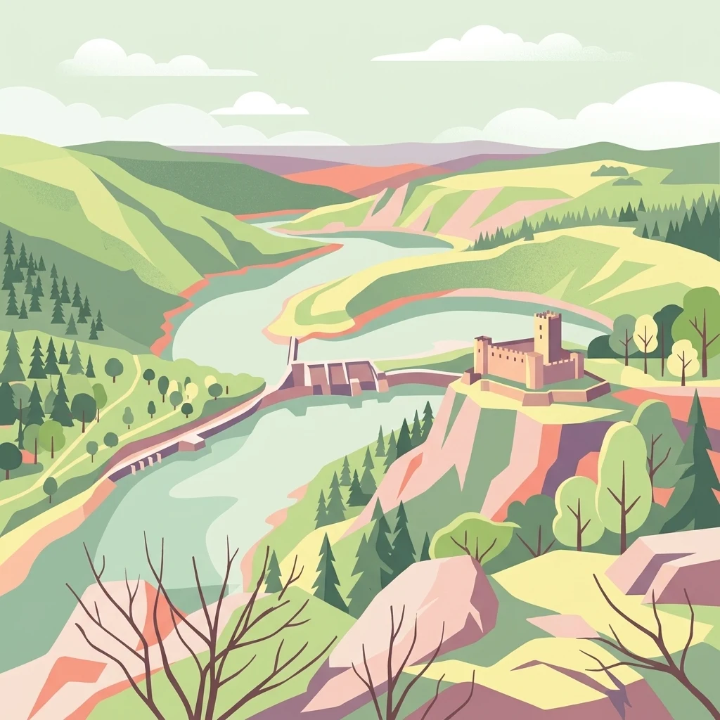
A stylized flat vector illustration of the Loire River gorge landscape, including rolling green hills, a dam, and a medieval-style castle on a cliff.

Réserve naturelle régionale des gorges de la Loire

Regional park

Park overview

Structured park overview, official facts, and landscape profile for Réserve naturelle régionale des gorges de la Loire

Réserve naturelle régionale des gorges de la Loire park facts, protected area profile, and essential visitor context

Review the core facts for Réserve naturelle régionale des gorges de la Loire, including designation, size, terrain, visitor scale, habitats, and operating context in one park-focused overview.

About Réserve naturelle régionale des gorges de la Loire

The Réserve naturelle régionale des gorges de la Loire is a protected natural area in the eastern Massif Central of France, focused on preserving one of the most scenic and ecologically varied stretches of the upper Loire valley. Although modest in size, it captures some of the most dramatic relief of the gorges, with steep slopes plunging toward the river and the reservoir of Grangent.

The reserve is part of a broader effort to safeguard the natural heritage of the gorges de la Loire while curbing the urban expansion of Saint-Étienne and neighboring communes. The land is composed of a mosaic of environments: dry rocky grasslands clinging to the cliffs, shrubby heaths, meadows, wooded valleys, and stands of mixed forest. This diversity of physical conditions is the primary reason the area hosts an unusually broad range of species, including plants and animals with Atlantic, Mediterranean, and montane affinities that rarely overlap in a single location.

Beyond its conservation role, the reserve functions as a public green space for the surrounding urban population. It is open throughout the year and crossed by an extensive network of marked footpaths, with educational activities and guided visits organized through the Maison de la réserve. As a regional nature reserve, it is governed through a 20-year protection framework and managed jointly by a local mixed syndicate and an environmental NGO, reflecting the cooperative approach typical of the French RNR system.

Quick facts and research context for Réserve naturelle régionale des gorges de la Loire

The Réserve naturelle régionale des gorges de la Loire is a regional nature reserve (RNR) in France, classified under IUCN Category IV. It lies in the Loire department of the Auvergne-Rhône-Alpes region, just south of Saint-Étienne, and extends along the right bank of the Loire River downstream of Lac de Grangent.

Created in 1988 as a voluntary nature reserve (réserve naturelle volontaire) and reclassified as a regional nature reserve on 12 July 2012, the site now covers roughly 355 hectares. It is co-managed by France nature environnement Loire (FNE Loire) and the Syndicat mixte d'aménagement des gorges de la Loire (SMAGL), and is open year-round to visitors.

Protection and recognition

Documented terrestrial protection scope, 2012 establishment year, and international recognition facts

Protection Status and Designation History for Réserve naturelle régionale des gorges de la Loire

Terrestrial protection status for Réserve naturelle régionale des gorges de la Loire traces back to the established designation year of 2012. Structured conservation records outline the formal management scope and official administrative parameters associated with the protected area.

Protection details

Protection scope
Terrestrial
Designated year
2012
Transboundary protection
No
WDPA ID
555559623
Park context

Deeper park guide and search-rich context for Réserve naturelle régionale des gorges de la Loire

Réserve naturelle régionale des gorges de la Loire history, landscape, wildlife, and travel context

Explore Réserve naturelle régionale des gorges de la Loire through its history, landscape character, ecosystems, wildlife, conservation priorities, cultural context, and seasonal travel timing in a structured park guide built for atlas discovery and search intent.

Why Réserve naturelle régionale des gorges de la Loire stands out

The reserve is best known for its dramatic, rugged landscape within the gorges of the Loire, where steep slopes, rocky cliffs, dry grasslands, heaths, and forests combine into a remarkably diverse mosaic of habitats in close proximity to the city of Saint-Étienne. It is also recognized for its exceptional biodiversity relative to its size, supporting more than 160 bird species, hundreds of butterfly species, and a notable array of amphibians, reptiles, and insects, including species of Atlantic, Mediterranean, and montane affinity. The combination of conservation, public access, and proximity to a major city makes it a notable example of peri-urban nature protection in France.
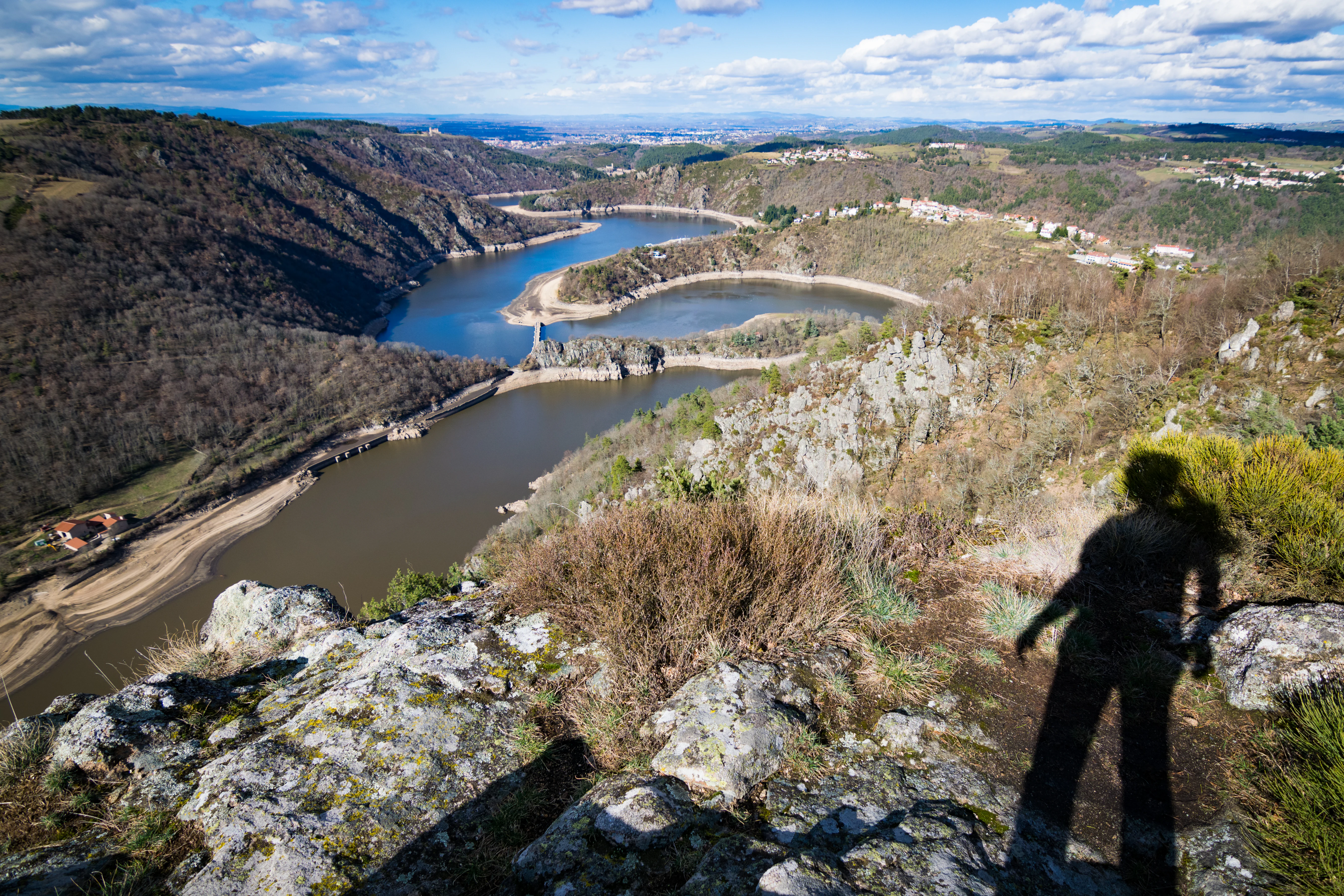
A high-angle scenic view looking down over a river that meanders through deep, forested gorges, with a rocky foreground and the shadow of a person visible on the right.
Panoramic view of the Loire River winding through the Gorges de la Loire, seen from a high rocky viewpoint.

Réserve naturelle régionale des gorges de la Loire history and protected-area timeline

The protection of this stretch of the Loire gorges was initiated in the mid-1980s by the commune of Saint-Étienne, which owns part of the territory. In 1986, the process of creating a nature reserve was launched, and on 8 March 1988 the area was officially classified as a réserve naturelle volontaire (voluntary nature reserve) under the name réserve naturelle volontaire de Saint-Étienne/Saint-Victor. At that stage, the protected zone covered 214 hectares along the right bank of the Loire, beginning downstream of Lac de Grangent.

In 1996, the reserve expanded onto parcels in the neighboring commune of Unieux, increasing its surface area to roughly 314 hectares. The principal aim of the classification was to contain the urban expansion of Saint-Étienne and nearby towns into the gorges, which were increasingly threatened by suburban development.

A major change occurred in 2012. On 12 July 2012, the area was reclassified as a réserve naturelle régionale (regional nature reserve), a stronger and more binding protection status, for a renewable period of 20 years. This reclassification also enlarged the reserve to approximately 355 hectares and placed it under the joint stewardship of France nature environnement Loire and the Syndicat mixte d'aménagement des gorges de la Loire.

Réserve naturelle régionale des gorges de la Loire landscape and geographic character

The reserve lies within the gorges de la Loire, where the river has carved a deeply incised valley into the uplands of the eastern Massif Central. The terrain is highly accidenté, marked by steep slopes, cliffs, and rocky outcrops that descend abruptly toward the river and the downstream reach of Lac de Grangent.

This rugged relief generates a remarkable variety of micro-landscapes within a relatively small area. Visitors can find exposed rocky ridges, dry grasslands and pelouses clinging to sun-warmed slopes, cooler wooded valleys and vallons, shrubby heaths, and mixed forests covering the more stable ground. The contrast between the open, sun-exposed upper slopes and the shaded, humid valley bottom contributes significantly to the diversity of habitats found in the reserve, and shapes the distribution of both flora and fauna across the gorges.
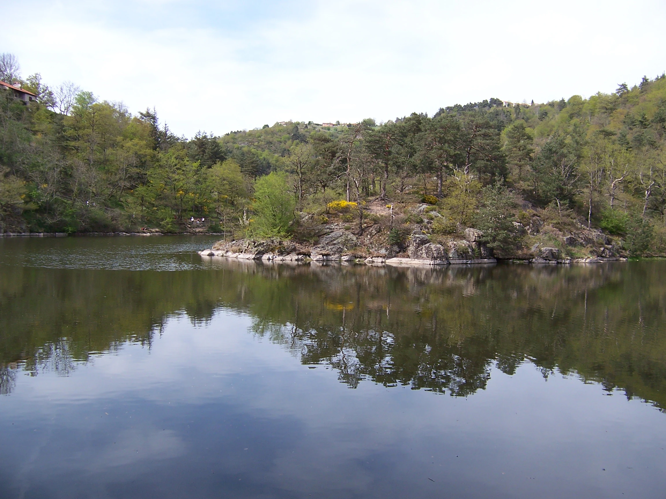
A peaceful lake surface reflecting a rocky, forested islet under a clear, bright sky.
A calm view of Lac de Grangent within the Gorges de la Loire reserve.

Réserve naturelle régionale des gorges de la Loire ecosystems, habitats, and plant life

The ecological character of the reserve is defined by the interplay between its rugged relief and the convergence of several climatic influences. The southern exposure of the slopes and the sheltering effect of the valley bring together species of Atlantic, Mediterranean, and montane affinity that would not normally overlap in a single site.

The vegetation reflects this diversity. Open habitats include dry pelouses and rocky areas with species such as asarine couchée, genêt purgatif, and Véronique de Dillenius. Shrubby layers feature amélanchier, while cooler and more montane microclimates support groseillier des Alpes and trèfle souterrain. More thermophilic woodland elements, such as érable de Montpellier, reflect the warmer exposures of the gorges. Together these habitats create a compact but ecologically rich mosaic unusual for a peri-urban protected area.

Réserve naturelle régionale des gorges de la Loire wildlife and species highlights

The reserve is particularly notable for its avifaune, with more than 160 bird species recorded, including high-profile raptors such as the Grand-duc d'Europe, the Circaète Jean-le-blanc, and the Milan royal. The combination of cliffs, open slopes, and wooded valleys provides a wide range of nesting and hunting habitats for these birds.

Invertebrate life is also exceptionally rich. At least 439 species of butterflies have been recorded, including the protected Azuré du serpolet. Amphibians and reptiles are represented by around 21 species, among them the Sonneur à ventre jaune, which is of significant conservation concern in France. The site also hosts the Lucane cerf-volant and a regionally notable endemic beetle, the Carabus hispanus subspecies bernardii, underscoring the reserve's importance for neglected but ecologically significant insect groups.

Réserve naturelle régionale des gorges de la Loire conservation status and protection priorities

The reserve plays a significant conservation role in an area otherwise dominated by industrial and urban pressures around Saint-Étienne. By establishing a long-term protected framework, it safeguards a mosaic of habitats in the gorges de la Loire that would otherwise be vulnerable to urban sprawl, infrastructure development, and land-use change.

Its value is enhanced by the unusually high biodiversity packed into a small area: more than 160 bird species, hundreds of butterfly species, and a number of protected amphibians, reptiles, and insects, including endemic or range-restricted taxa. The 2012 reclassification as a regional nature reserve strengthened the legal protection of the site and tied it to a 20-year management cycle, giving it a more durable role in the regional conservation network of Auvergne-Rhône-Alpes.

Réserve naturelle régionale des gorges de la Loire cultural meaning and human context

The reserve is closely tied to the identity of Saint-Étienne and the surrounding communes of the Loire department. As a green space embedded in an urban and industrial region, it represents an important effort to reclaim and revalue the natural heritage of the gorges de la Loire, which have long served as a distinctive geographical and visual feature of the area.

The co-management by a local mixed syndicate (SMAGL) and an environmental NGO (FNE Loire) reflects a strong tradition of public and associative partnership in French nature conservation. Educational activities and guided visits arranged through the Maison de la réserve emphasize the role of the gorges as a place of shared regional heritage, not only as an ecological refuge but also as a setting for environmental awareness and community engagement.

Top sights and standout views in Réserve naturelle régionale des gorges de la Loire

Highlights of the reserve include the dramatic scenery of the gorges de la Loire immediately upstream of Lac de Grangent, and the unusually diverse mosaic of habitats found within a relatively small protected area.

Visitors can explore more than 23 km of marked trails, observe raptors and other wildlife on the cliffs and slopes, and engage with the area's natural heritage through the educational programs run from the Maison de la réserve. The reserve stands out as a successful example of peri-urban nature protection, combining strong biodiversity value with easy access for residents of the Saint-Étienne metropolitan area.

Best time to visit Réserve naturelle régionale des gorges de la Loire

The reserve is open to the public year-round, and the experience varies significantly with the seasons. Spring is one of the most rewarding periods, when wildflowers bloom across the slopes and the pelouses come alive with butterflies, including species such as the Azuré du serpolet, and birds of prey become more visibly active.

Summer brings warm, dry conditions on the exposed rocky slopes and is well suited to exploring the open landscapes and flora of thermophilic habitats, while autumn offers a quieter atmosphere and richer colors in the wooded valleys. Winter visits are also possible, with the rugged relief taking on a particularly austere character and offering good conditions for spotting raptors and other resident wildlife along the cliffs.
Monthly climate preview

Long term temperature and precipitation normals for the protected landscape

Réserve naturelle régionale des gorges de la Loire Climate and Weather by Month

Representative coordinate records show measured monthly temperature variations alongside steady precipitation patterns across the elevation profile. Analyzing the complete twelve month climatology dataset reveals detailed thermal swings and moisture distribution across the protected area.
Annual mean10 °C
1 °C20 °C
Jan
Feb
Mar
Apr
May13°
Jun17°
Jul20°
Aug20°
Sep15°
Oct11°
Nov
Dec
Warmest month
July

20.1 °C

Coolest month
January

1.1 °C

Wettest month
October

2.5 mm/day

Driest month
March

1.2 mm/day

Park location guide

Geography guide, regional context, and park location map for Réserve naturelle régionale des gorges de la Loire

Réserve naturelle régionale des gorges de la Loire park geography, regions, and map view in France

Understand where Réserve naturelle régionale des gorges de la Loire sits in France through a broader geographic reading of the surrounding landscape, nearby location context, and its mapped position within the national park landscape.

How Réserve naturelle régionale des gorges de la Loire fits into France

France is a unitary semi-presidential republic and one of the world's largest economies. It borders Belgium, Luxembourg, Germany, Switzerland, Italy, Monaco, Andorra, and Spain, with a maritime border to the United Kingdom. The country is known for its cultural influence, art, cuisine, and political history spanning centuries.

Wider geography shaping Réserve naturelle régionale des gorges de la Loire in France

France is located in Western Europe. Metropolitan France extends from the Rhine to the Atlantic Ocean and from the Mediterranean Sea to the English Channel and North Sea. The country borders Belgium, Luxembourg, Germany, Switzerland, Italy, Monaco, Andorra, Spain, and has a maritime border with the United Kingdom.

Map view of Réserve naturelle régionale des gorges de la Loire

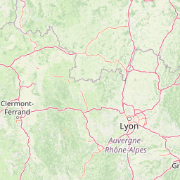
Use this park location map to pinpoint Réserve naturelle régionale des gorges de la Loire in France, understand its exact geographic position, and read its mapped placement within the surrounding landscape more clearly.

Pigeon | © OpenStreetMap contributors

Location context for Réserve naturelle régionale des gorges de la Loire

Auvergne-Rhône-Alpes
Recorded earthquake history

Explore Recorded Seismic History Near Réserve naturelle régionale des gorges de la Loire

Review the documented catalogue of past seismic activity mapped to the vicinity of Réserve naturelle régionale des gorges de la Loire. These MoriAtlas records offer a clear look at historical event data for the rugged terrain of this French regional nature reserve.

Réserve naturelle régionale des gorges de la Loire Earthquake Records

Catalogued events

10 events

Strongest magnitude

Magnitude 3.5

Most recent event

Nov 5, 2001

This history includes earthquakes recorded inside the park or within 50 km of its borders

Explore the dramatic terrain, rocky cliffs, and diverse protected habitats through detailed park photography

Visualizing Réserve naturelle régionale des gorges de la Loire Photos, Landscapes, and Scenery

Visual records reveal the rugged topography, steep river gorges, and varied micro-landscapes that define Réserve naturelle régionale des gorges de la Loire. Examining these protected habitats provides deeper insight into the ecological character and natural morphology of the valley.

A high-angle scenic view looking down over a river that meanders through deep, forested gorges, with a rocky foreground and the shadow of a person visible on the right.

An aerial view of an island in a river featuring an old stone castle, surrounded by hills, forests, and calm water.

A peaceful lake surface reflecting a rocky, forested islet under a clear, bright sky.

Park atlas

Compare surrounding regional protected landscapes and river valley terrain

Parks Near Réserve naturelle régionale des gorges de la Loire

Browse other protected areas near Réserve naturelle régionale des gorges de la Loire to examine similar river valley geography and rugged upland habitats. Exploring these adjacent natural reserves expands regional terrain comparison and reveals broader conservation patterns across the surrounding uplands.
A soft watercolor painting of a rolling landscape with green fields, distant purple hills, and patches of yellow and pink vegetation.
Nature reserveAuvergne-Rhône-Alpes
37 km away#1 closest

Northwest

Réserve naturelle régionale des Jasseries de Colleigne Protected Area and Landscape Atlas

High-altitude moorlands and glacial geography in the Monts du Forez

This regional nature reserve provides a critical look at the Hautes Chaumes du Forez, an upland plateau in the Massif Central characterized by open grasslands and peat bogs. The site serves as a vital case study for the conservation of rare montane habitats maintained through traditional pastoral farming practices. Map the glacial Chorsin valley and explore the diverse botanical landscape contained within these protected high-altitude boundaries.

Area
2.85 km²
Established
1985
IUCN
IV
Relief
Mountain
A watercolor illustration of a serene landscape with rolling hills, a meandering river, and soft light.
Regional parkAuvergne-Rhône-Alpes
42 km away#2 closest

South

Parc naturel régional des Monts d'Ardèche: Protected Landscapes and Geographic Map Context

Volcanic highland terrain within the Auvergne-Rhône-Alpes region

Covering over 248,000 hectares, Parc naturel régional des Monts d'Ardèche represents a significant protected area in the southern Massif Central. The region is marked by its distinctive volcanic sucs, including Mont Gerbier-de-Jonc, and a complex network of Cévenol river valleys. It remains a focal point for understanding the transition between high volcanic plateaus and traditional terraced agricultural slopes in southeastern France.

Area
2,280 km²
Established
2001
IUCN
V
Nature reserveAuvergne-Rhône-Alpes
44 km away#3 closest

Southwest

Réserve naturelle régionale du lac de Malaguet: Regional Nature Reserve and Wetland Atlas

Mapped protected landscapes in Haute-Loire, Auvergne-Rhône-Alpes

This protected area centers on a 14th-century artificial lake that now functions as a rich ecological sanctuary. Explore the confluence of medieval water infrastructure, riparian forests, and meadow zones that support diverse upland fauna. The site offers a clear example of long-term landscape transformation from industrial utility to a protected biodiversity refuge within the eastern Massif Central.

Area
0.542 km²
Established
2014
IUCN
IV
Relief
Upland
Nature reserveAuvergne-Rhône-Alpes
About 46 km away#4 closest

Northeast

Réserve naturelle régionale de la mine du Verdy: A Subterranean Protected Area in France

Mapping the ecological geography of the Monts du Lyonnais.

The Réserve naturelle régionale de la mine du Verdy stands as France's smallest nature reserve, protecting an intricate network of abandoned mining galleries beneath the surface of the Monts du Lyonnais. This site serves as a crucial underground sanctuary for diverse bat species and cave-dwelling invertebrates, showcasing how repurposed industrial landscapes can harbor significant biodiversity within the Auvergne-Rhône-Alpes region.

Area
0.001 km²
Established
1990
IUCN
IV
Relief
Upland
A soft watercolor painting of a wetland landscape featuring a central pond, surrounding reeds, and distant rolling hills in pale green and pink hues.
Nature reserveAuvergne-Rhône-Alpes
About 72 km away#5 closest

East

Réserve naturelle régionale de l'étang de Saint-Bonnet: Wetland Atlas and Map Discovery

Examining protected wetland geography in the Isère department

This protected area centers on the étang de Saint-Bonnet, a wetland habitat defined by dense reedbeds and pond-centered ecosystems. It provides a distinct example of nature conservation situated between major urban corridors, showcasing how amphibians and diverse bird communities thrive within a small, managed lowland basin.

Area
0.514 km²
Established
1987
IUCN
IV
Relief
Lowland
Nature reserveAuvergne-Rhône-Alpes
About 88 km away#6 closest

West

Réserve naturelle régionale du Puy de Marmant: Volcanic Geography and Protected Terrain

Regional nature reserve in the Auvergne-Rhône-Alpes landscape.

This protected site preserves a prominent volcanic hill and its surrounding dry grasslands within the Limagne basin. The reserve serves as an ecologically significant island, maintaining specialized thermophilous plants and rare geological formations composed of basalt and peperite. It remains an essential reference for understanding the volcanic heritage and unique botanical diversity of the Puy-de-Dôme department.

Area
0.203 km²
Established
1985
IUCN
IV
Relief
Upland
A soft watercolor painting of a wide, rolling landscape with green hills, pale mountain silhouettes in the background, and a faint reddish-brown foreground, presented on a white background.
Natural monumentAuvergne-Rhône-Alpes
92 km away#7 closest

West

Chaîne des Puys - faille de Limagne: Mapping Volcanic and Tectonic Protected Landscapes

Geological exploration of the Auvergne-Rhône-Alpes volcanic chain

Spanning a rhythmic skyline of roughly eighty volcanoes, the Chaîne des Puys - faille de Limagne represents a premier site for studying continental rifting and volcanic landforms. This protected monument offers a clear view into the interplay between the ancient mountain basement, the massive Limagne fault, and the resulting volcanic edifices that define the regional identity of the Auvergne-Rhône-Alpes area.

Area
242.23 km²
Established
2018
Relief
Mountain
Climate
Temperate
A wide watercolor illustration showing a river flowing through a green valley with distant purple mountains and a large reddish rock formation on the right bank.
Protected areaFrance
About 95 km away#8 closest

South

Ripisylve et lit majeur de l'Ardèche: Protected Area and Alluvial River Geography

A vital riparian corridor in the French Ardèche valley.

This protected area centers on the active Ardèche river channel and its adjacent floodplain. The site features a rich diversity of humid habitats, ranging from quiet pools and side channels to sediment rich gravel deposits. It serves as an ecologically significant corridor for riparian woodland, providing a habitat structure that is central to the environmental health of the region.

Area
2.87 km²
Established
1999
Relief
Lowland
Climate
Temperate

Common questions about visiting, size, designation, and location context for Réserve naturelle régionale des gorges de la Loire

Réserve naturelle régionale des gorges de la Loire FAQs for park facts, access, geography, and protected area context

Find quick answers about Réserve naturelle régionale des gorges de la Loire, including protected-area facts, park geography, trail and visitor context, and how the park fits into its surrounding country and regional landscape.
MoriAtlas Explorer

Continue Your Protected Areas Search Across the Global Atlas

Deepen your exploration by continuing the structured search for national parks and protected areas worldwide. Utilize the comprehensive filtering capabilities to compare different conservation landscapes and refine your understanding of global park geography. Discover more about the distribution and characteristics of protected natural areas.

Global natural geography