
Mori Atlas logo
Protected areaRipisylve et lit majeur de l'Ardèche

Examining the dynamic river morphology and wetland mosaic within this vital French conservation site.

Ripisylve et lit majeur de l'Ardèche: A Protected Riparian Corridor and Alluvial Landscape

Ripisylve et lit majeur de l'Ardèche comprises a significant ten kilometer stretch of the middle Ardèche river valley in France. This protected area features a diverse mosaic of alluvial habitats, including active river channels, gravel bars, and secondary wetlands that support essential biodiversity. The site serves as a prime example of a mobile riverbed system and is recognized for its well preserved riparian woodland corridor that connects directly to the wider Natura 2000 network.

riparian forestriver valleyalluvial wetlandsZNIEFFNatura 2000European beaver
A stylized digital illustration showing a waterfall cascading from a rocky cliff into a winding river, surrounded by green trees and a distant mesa under a blue sky.

Ripisylve et lit majeur de l'Ardèche

Protected area

Park overview

Structured park overview, official facts, and landscape profile for Ripisylve et lit majeur de l'Ardèche

Ripisylve et lit majeur de l'Ardèche park facts, protected area profile, and essential visitor context

Review the core facts for Ripisylve et lit majeur de l'Ardèche, including designation, size, terrain, visitor scale, habitats, and operating context in one park-focused overview.

About Ripisylve et lit majeur de l'Ardèche

Ripisylve et lit majeur de l'Ardèche is a designated natural site that protects a representative section of the middle Ardèche river valley, where the river's principal channel and its associated floodplain habitats remain in a remarkably natural condition. Located near Aubenas in the southern part of the Ardèche department, the site captures the dynamic character of a Mediterranean-influenced river system: a mobile streambed, shifting substrates, and a rich mosaic of alluvial environments stretching outward from the active channel.

The site's ecological importance has been recognized through its classification as a type I ZNIEFF, a French designation applied to areas of strong ecological interest for wildlife and habitats. Beyond this national-level recognition, the area also contributes to the Natura 2000 network as part of the Vallée moyenne de l'Ardèche et ses Affluents site, integrating it into a wider framework of European habitat conservation.

What distinguishes the area is the diversity of humid environments it concentrates in a compact valley section. Beyond the main channel, the site includes braided sections, secondary channels, peripheral ponds, and small tributary streams. These features support riparian woodland, or ripisylve, a forest community adapted to periodic flooding and high water tables. The combination of these habitats makes the site a valuable reference point for understanding low-elevation river ecology in the Ardèche basin.

Although modest in size, the protected area plays an important role in maintaining habitat continuity along the Ardèche river, which is itself a defining geographical and ecological feature of the region. By safeguarding both the active channel and the surrounding wetland mosaic, the site helps preserve the natural processes that sustain river biodiversity in southeastern France.

Quick facts and research context for Ripisylve et lit majeur de l'Ardèche

This is a type I ZNIEFF located in the Ardèche department of southeastern France, near the town of Aubenas. It was formally registered in 1999 and covers roughly 287 hectares along the middle Ardèche river. The protected area extends across six communes: Aubenas, Saint-Didier-sous-Aubenas, Saint-Étienne-de-Fontbellon, Saint-Privat, Ucel, and Vogüé. It is integrated into the larger Vallée moyenne de l'Ardèche et ses Affluents Natura 2000 site, linking it to broader European habitat protection frameworks.

Protection and recognition

Terrestrial conservation scope and recognized protected area data parameters

Ripisylve et lit majeur de l'Ardèche Protection Status and Designation Records

Terrestrial protection status records outline the administrative boundaries and official conservation scope established for Ripisylve et lit majeur de l'Ardèche. Structured protection data details the documented management framework without implying unverified international recognition.

Protection details

Protection scope
Terrestrial
Transboundary protection
No
Park context

Deeper park guide and search-rich context for Ripisylve et lit majeur de l'Ardèche

Ripisylve et lit majeur de l'Ardèche history, landscape, wildlife, and travel context

Explore Ripisylve et lit majeur de l'Ardèche through its history, landscape character, ecosystems, wildlife, conservation priorities, cultural context, and seasonal travel timing in a structured park guide built for atlas discovery and search intent.

Why Ripisylve et lit majeur de l'Ardèche stands out

The site is best known for preserving a continuous stretch of riparian woodland and active river channel along the Ardèche river. Its combination of a mobile riverbed, varied substrates, peripheral ponds, secondary channels, and small tributaries creates one of the more ecologically rich lowland river corridors in the region. The presence of European beaver and European otter reinforces its reputation as one of the most biodiverse riverine sections of the middle Ardèche.
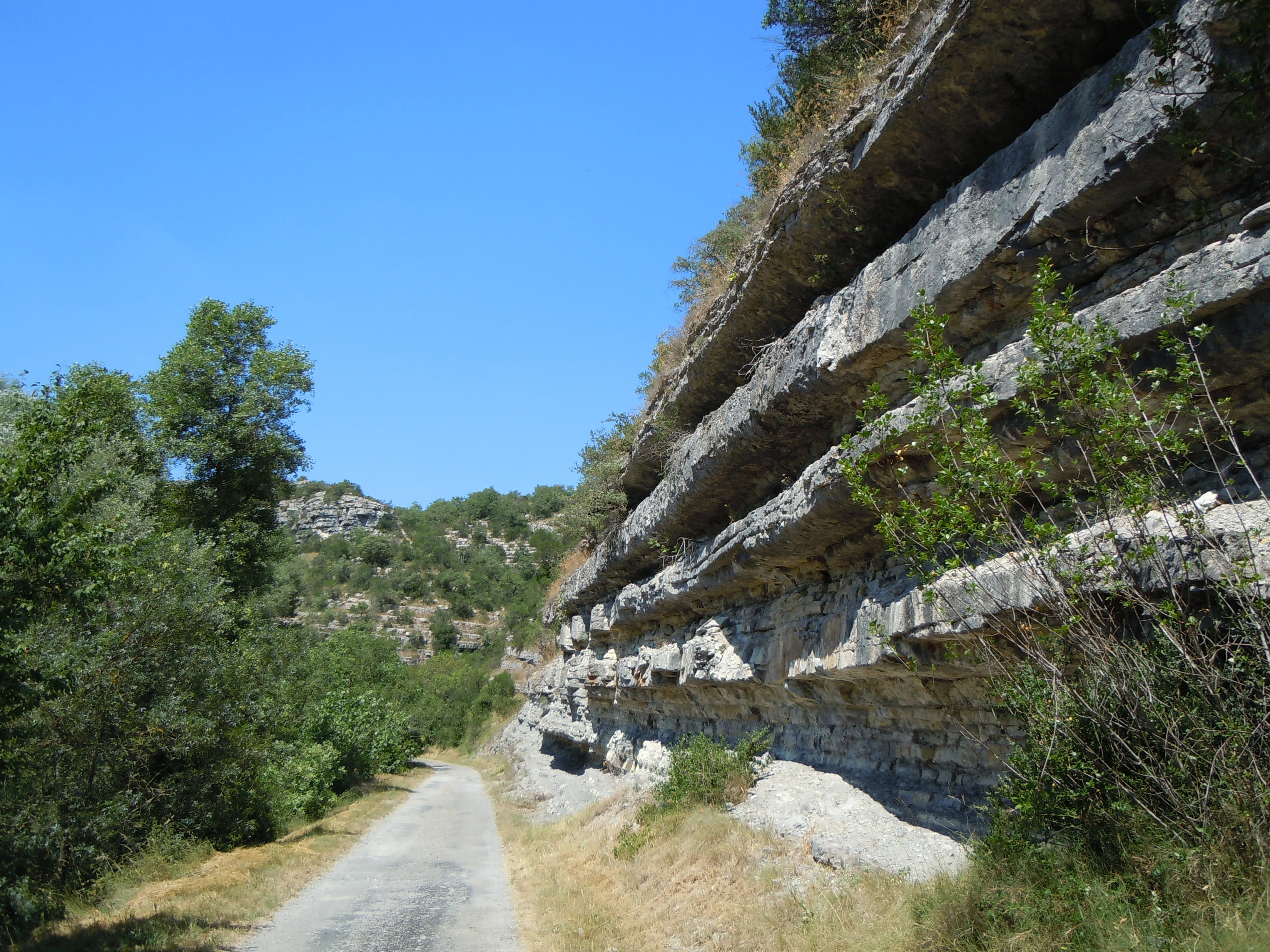
A gravel path runs alongside a large, layered limestone cliff face with green trees and vegetation on the left, under a clear blue sky.
Layered limestone cliffs tower over a gravel path next to the riparian forest of the Ardeche River in Vogue, France.

Ripisylve et lit majeur de l'Ardèche history and protected-area timeline

The site was formally registered as a ZNIEFF in 1999, formalizing its recognition as an area of high ecological value. Its inclusion within the Natura 2000 Vallée moyenne de l'Ardèche et ses Affluents site reflects the broader regional effort during the late 1990s and early 2000s to identify and protect key riverine and alluvial habitats across the Ardèche basin. The protection status reflects growing awareness of the ecological importance of the river's riparian forests and its mobile channel morphology.

Ripisylve et lit majeur de l'Ardèche landscape and geographic character

The landscape is shaped by the Ardèche river as it winds through a valley flanked by limestone terrain. Within the protected area, the river maintains a relatively mobile bed with diverse flow patterns and substrates, ranging from finer sediments to coarser gravel deposits that shift over time. These conditions create a mosaic of bars, banks, side channels, and small islands that change with each major flood event.

Peripheral to the main channel, the broader valley floor extends into quiet wetland environments. Pools, secondary channels, and small tributary streams create a transition zone between the flowing river and the surrounding terrestrial habitats. The result is a varied alluvial corridor in which water, sediment, and vegetation interact continuously. The image of the Vogüé limestone cliffs along the river illustrates the dramatic geological context in which these soft alluvial features are set.

Ripisylve et lit majeur de l'Ardèche ecosystems, habitats, and plant life

The site supports a richly layered alluvial ecosystem built around the interplay between flowing water and floodplain habitats. The riparian forest along the banks is a defining ecological element, formed by tree and shrub species adapted to seasonal flooding and saturated soils.

Beyond the woodland, the area contains a wide range of humid microhabitats: standing water in side pools, slow-moving reaches in secondary channels, gravel bars, and small tributary confluences. This habitat variety supports a diverse community of invertebrates, fish, amphibians, and wetland plants. The lower downstream sections of the protected stretch are noted for retaining particularly remarkable alluvial environments, making the site an important reference area for lowland river conservation in the region.

Ripisylve et lit majeur de l'Ardèche wildlife and species highlights

The site is recognized for the presence of two flagship mammal species: the European beaver and the European otter. Both species depend on healthy river systems and are considered strong indicators of ecological integrity. The European beaver benefits from the availability of woody riparian vegetation and stable banks, while the European otter requires clean water and rich prey populations, including fish and amphibians.

Beyond these protected mammals, the mosaic of river, riparian forest, ponds, and tributary streams provides habitat for a wider community of invertebrates, fish, amphibians, and birds associated with Mediterranean river corridors. The dynamic nature of the riverbed, with its shifting substrates and varied flow conditions, contributes to the structural complexity that supports this broader biodiversity.

Ripisylve et lit majeur de l'Ardèche conservation status and protection priorities

The site is primarily valued as a conservation unit for its role in protecting a representative section of the middle Ardèche river and its associated floodplain habitats. Its ZNIEFF type I classification reflects strong regional-level ecological interest, while its inclusion in the Vallée moyenne de l'Ardèche et ses Affluents Natura 2000 site connects it to networks of habitat protection across Europe.

Conservation interest centers on the preservation of natural river dynamics, including the mobility of the streambed, the diversity of substrates, and the continuity of riparian woodland. Peripheral wetlands such as pools, secondary channels, and small tributaries are also considered important features, since they extend the ecological value of the site beyond the main channel. By protecting both the active river and its surrounding wetland mosaic, the site contributes to maintaining biodiversity and ecological corridors along the Ardèche basin.

Top sights and standout views in Ripisylve et lit majeur de l'Ardèche

The site's main highlights include its continuous riparian woodland corridor, the dynamic and varied morphology of the Ardèche riverbed, and the unusually rich mosaic of peripheral wetlands such as ponds, secondary channels, and tributary confluences. The downstream portion of the protected stretch is particularly noted for the quality of its alluvial environments. Together, these features give the area a compact but distinctive ecological identity within the broader Ardèche valley.
Monthly climate preview

Long-term representative point measurements for annual temperature and precipitation

Ripisylve et lit majeur de l'Ardèche Climate Normals and Temperature Rhythms

Representative coordinates record measured monthly temperature swings from subfreezing winter minimums to warm summer maximums alongside varying precipitation levels. Opening the complete twelve-month record reveals full seasonal climate normals and detailed meteorological distributions across the protected landscape.
Annual mean11 °C
3 °C22 °C
Jan
Feb
Mar
Apr10°
May14°
Jun19°
Jul22°
Aug22°
Sep17°
Oct12°
Nov
Dec
Warmest month
July

22 °C

Coolest month
January

2.6 °C

Wettest month
November

3.7 mm/day

Driest month
July

1.5 mm/day

Park location guide

Geography guide, regional context, and park location map for Ripisylve et lit majeur de l'Ardèche

Ripisylve et lit majeur de l'Ardèche park geography, regions, and map view in France

Understand where Ripisylve et lit majeur de l'Ardèche sits in France through a broader geographic reading of the surrounding landscape, nearby location context, and its mapped position within the national park landscape.

How Ripisylve et lit majeur de l'Ardèche fits into France

France is a unitary semi-presidential republic and one of the world's largest economies. It borders Belgium, Luxembourg, Germany, Switzerland, Italy, Monaco, Andorra, and Spain, with a maritime border to the United Kingdom. The country is known for its cultural influence, art, cuisine, and political history spanning centuries.

Wider geography shaping Ripisylve et lit majeur de l'Ardèche in France

France is located in Western Europe. Metropolitan France extends from the Rhine to the Atlantic Ocean and from the Mediterranean Sea to the English Channel and North Sea. The country borders Belgium, Luxembourg, Germany, Switzerland, Italy, Monaco, Andorra, Spain, and has a maritime border with the United Kingdom.

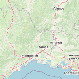
Map view of Ripisylve et lit majeur de l'Ardèche

Use this park location map to pinpoint Ripisylve et lit majeur de l'Ardèche in France, understand its exact geographic position, and read its mapped placement within the surrounding landscape more clearly.

Pigeon | © OpenStreetMap contributors

Examine the dynamic river morphology, alluvial wetlands, and limestone valley scenery of southern France.

Visual Exploration and Landscape Photography of Ripisylve et lit majeur de l'Ardèche

Visual documentation captures the continuous riparian woodland corridor, mobile riverbeds, and diverse floodplain habitats defining Ripisylve et lit majeur de l'Ardèche. Photographic records reveal the intricate terrain, seasonal water patterns, and protected riverine environments supporting local wildlife populations.

A gravel path runs alongside a large, layered limestone cliff face with green trees and vegetation on the left, under a clear blue sky.

A wide river with clear blue water and scattered white rocks, flanked by green trees and a rocky hill in the background.

Park atlas

Compare adjacent river valleys and regional conservation landscapes

Parks Near Ripisylve et lit majeur de l'Ardèche and Surrounding Protected Areas

Browse nearby protected areas and connected river corridors located close to Ripisylve et lit majeur de l'Ardèche for deeper regional geography comparison. Exploring adjacent natural habitats helps contextualize local floodplain ecosystems within the wider southern French river network.
A watercolor illustration of a serene landscape with rolling hills, a meandering river, and soft light.
Regional parkAuvergne-Rhône-Alpes
About 5 km away#1 closest

Northwest

Parc naturel régional des Monts d'Ardèche: Protected Landscapes and Geographic Map Context

Volcanic highland terrain within the Auvergne-Rhône-Alpes region

Covering over 248,000 hectares, Parc naturel régional des Monts d'Ardèche represents a significant protected area in the southern Massif Central. The region is marked by its distinctive volcanic sucs, including Mont Gerbier-de-Jonc, and a complex network of Cévenol river valleys. It remains a focal point for understanding the transition between high volcanic plateaus and traditional terraced agricultural slopes in southeastern France.

Area
2,280 km²
Established
2001
IUCN
V
A soft watercolor painting showing a wide, panoramic view of rolling green hills, distant ridges, and gentle scrub vegetation against a white background.
Regional parkAuvergne-Rhône-Alpes
About 28 km away#2 closest

Southwest

Réserve naturelle régionale des Grads de Naves: Regional Park and Limestone Plateau Geography

Mediterranean habitat in the southern Ardèche region of France

Situated near Les Vans, the Réserve naturelle régionale des Grads de Naves is a small but biologically significant limestone plateau. This protected area demonstrates the natural reclamation of former cultivated farmland, now featuring a dense community of Mediterranean flora, breeding birds, and butterfly species within an iconic garrigue and oak-scrub landscape.

Area
0.12 km²
Established
1981
IUCN
IV
Relief
Upland
Watercolor illustration of green fields, a river, and mountains under a soft pink and yellow sky
National parkOccitanie
About 40 km away#3 closest

Southwest

Cévennes National Park: Explore its Mapped Terrain and Protected Landscape in Occitanie

Discover the unique geographic context and park boundaries.

Cévennes National Park, situated in Occitanie, France, offers a rich exploration of mid-mountain Mediterranean geography. As a protected landscape, its mapped terrain features dramatic limestone plateaus, deep river gorges, and distinct granite massifs. This entry provides essential geographic context for Cévennes National Park, highlighting its unique natural features and its significance as a protected area within the broader regional atlas.

Area
937 km²
Established
1970
IUCN
V
Visitors
800K annual
Nature reserveAuvergne-Rhône-Alpes
About 51 km away#4 closest

East

Réserve naturelle régionale du réseau de grottes à chauves-souris en Drôme et en Ardèche: Protected Area Overview

Subterranean habitat protection within the Auvergne-Rhône-Alpes regional geography.

This regional nature reserve secures vital karst cavities serving as essential refuges for multiple bat species. By bridging administrative boundaries in southeastern France, the protected area demonstrates a precise focus on underground ecology and the preservation of irreplaceable subterranean environments across the departments of Drôme and Ardèche.

Area
0.49 km²
Established
2019
IUCN
IV
Relief
Mixed relief
A watercolor painting of a soft, rolling landscape with green hills, light forest cover, and wild grasses in the foreground, rendered in a light, atmospheric style.
Nature reserveAuvergne-Rhône-Alpes
About 68 km away#5 closest

East

Réserve naturelle régionale de la grotte des Sadoux: Protected Cave and Forested Hills

Regional Nature Reserve in the Drôme department of France

The Réserve naturelle régionale de la grotte des Sadoux encompasses a 30-hectare forested coteau above the Courance valley. This site is defined by its subterranean karstic gallery and surrounding woodland edge, creating a focused conservation landscape for threatened bat species within the Auvergne-Rhône-Alpes region.

Area
0.3 km²
Established
2010
IUCN
IV
Relief
Upland
A soft watercolor painting of a winding river flowing through a gentle, rolling green valley with hills in the background.
Nature reserveOccitanie
About 69 km away#6 closest

South

Réserve naturelle régionale des gorges du Gardon: Geography and Protected Area Overview

Mediterranean river valley and raptor conservation corridor

Examine the distinct topography of the Réserve naturelle régionale des gorges du Gardon. The protected area features steep limestone cliffs and a river corridor that sustains dense Mediterranean oak forests. This site remains a critical node for raptor conservation, specifically supporting nesting Egyptian vultures and Bonelli eagles within its structured valley geography.

Area
4.913 km²
Established
2007
IUCN
IV
A soft watercolor illustration depicting layered rolling hills, distant mountain silhouettes, and clusters of trees in a pale color palette.
Regional parkProvence-Alpes-Côte d'Azur
About 87 km away#7 closest

Southeast

Parc naturel régional du Luberon: Regional Park Boundaries and Protected Landscape Atlas

Geology, mountain ridges, and Mediterranean ecosystems of Provence

Parc naturel régional du Luberon serves as a vital protected corridor in southeastern France. The park features three parallel limestone massifs, dramatic ochre formations, and fossil-rich plateaus. Its geography offers a case study in integrating sustainable land use with rich biodiversity across the Vaucluse and Alpes-de-Haute-Provence departments.

Area
1,747.26 km²
Established
1977
IUCN
V
Visitors
350K annual
Nature reserveProvence-Alpes-Côte d'Azur
About 88 km away#8 closest

Southeast

Réserve naturelle régionale Ermitage-Escampeaux: A Protected Landscape in the Vaucluse Department

Mapping regional nature reserves within inland Provence-Alpes-Côte d'Azur.

Located in the Villes-sur-Auzon commune, the Réserve naturelle régionale Ermitage-Escampeaux stands as a significant addition to the protected lands of Provence-Alpes-Côte d'Azur. This 252.9-hectare reserve offers a focused look at the transition between Mediterranean garrigue and the higher Provençal uplands, providing essential habitat conservation within a traditional rural mosaic.

Area
2.529 km²
Established
2026
IUCN
IV

Common questions about visiting, size, designation, and location context for Ripisylve et lit majeur de l'Ardèche

Ripisylve et lit majeur de l'Ardèche FAQs for park facts, access, geography, and protected area context

Find quick answers about Ripisylve et lit majeur de l'Ardèche, including protected-area facts, park geography, trail and visitor context, and how the park fits into its surrounding country and regional landscape.
MoriAtlas Explorer

Continue Your Protected Areas Search Across the Global Atlas

Deepen your exploration by continuing the structured search for national parks and protected areas worldwide. Utilize the comprehensive filtering capabilities to compare different conservation landscapes and refine your understanding of global park geography. Discover more about the distribution and characteristics of protected natural areas.

Global natural geography