Mori Atlas logo
Nature reserveRéserve naturelle régionale des landes, prairies et étangs de Plounérin

A preserved mosaic of inland heathland, traditional meadows, and wetland ponds in the Côtes-d'Armor

Réserve naturelle régionale des landes, prairies et étangs de Plounérin: Protected Landscape Geography

The Réserve naturelle régionale des landes, prairies et étangs de Plounérin safeguards a rare combination of three distinct Breton habitats within a single 160-hectare site. Located in the gently undulating interior of the Côtes-d'Armor, this protected area preserves a semi-natural landscape shaped by long-standing agricultural tradition. Through detailed map exploration, gain insight into the transition between these open heaths, managed pastures, and freshwater ponds that define the inland geography of Brittany.

regional nature reserveBrittanyCôtes-d'Armorheathlandmeadowponds

Réserve naturelle régionale des landes, prairies et étangs de Plounérin

Nature reserve

Park overview

Structured park overview, official facts, and landscape profile for Réserve naturelle régionale des landes, prairies et étangs de Plounérin

Réserve naturelle régionale des landes, prairies et étangs de Plounérin park facts, protected area profile, and essential visitor context

Review the core facts for Réserve naturelle régionale des landes, prairies et étangs de Plounérin, including designation, size, terrain, visitor scale, habitats, and operating context in one park-focused overview.

About Réserve naturelle régionale des landes, prairies et étangs de Plounérin

The Réserve naturelle régionale des landes, prairies et étangs de Plounérin is a regional nature reserve in Brittany, the western peninsula of France that retains strong regional identities in language, landscape, and land use. Located inland within the Côtes-d'Armor department, the reserve sits on the commune of Plounérin, in an area shaped more by pastoral agriculture and traditional rural land use than by coastal or mountain scenery.

The reserve covers roughly 160 hectares, a relatively modest size that is nonetheless meaningful within the French system of regional nature reserves. Such reserves (réserves naturelles régionales, or RNRs) are created by regional councils under French environmental law and are designed to protect habitats, species, or geological features of regional importance. Plounérin carries the RNR classification number 312, and within the international IUCN framework it is recognized as a Category IV protected area, a category that recognizes sites managed primarily for the conservation of particular habitats and species, often through active intervention.

What makes the Plounérin reserve distinctive is the deliberate integration of three habitat types into its name and identity. Heathland (landes) in this region refers to open, low-growing vegetation often dominated by heathers, gorse, and grasses; such habitats are cultural products of long histories of grazing, cutting, and burning. Meadows (prairies) are grasslands maintained through traditional mowing or grazing, which support a different suite of plants and animals than either forest or heath. Ponds (étangs) here are small freshwater bodies that enrich the landscape with wetland vegetation, amphibians, insects, and aquatic birds. Together these three habitats form a landscape mosaic that is now rare in much of lowland France due to agricultural intensification, drainage, and land conversion.

The reserve therefore represents an effort to conserve not a single habitat or charismatic species, but the broader ecological pattern of inland Brittany as it has existed for centuries. By maintaining this mosaic, the reserve helps protect the ecological processes and biodiversity that depend on the interaction between heath, meadow, and pond in close proximity.

Quick facts and research context for Réserve naturelle régionale des landes, prairies et étangs de Plounérin

The Réserve naturelle régionale des landes, prairies et étangs de Plounérin is a French regional nature reserve situated on the commune of Plounérin, in the Côtes-d'Armor department of Brittany. It was officially classified on 24 March 2016 by the Regional Council of Brittany following a formal deliberation, and operates under the RNR regional nature reserve designation (RNR312). With an area around 160.72 hectares, it falls within IUCN protected-area Category IV, reflecting its focus on habitat and species conservation through management.

Its name is itself a description of its conservation focus, indicating that the reserve protects three core habitat types: heathlands (landes), meadows (prairies), and ponds (étangs). This habitat mosaic is a defining feature of inland Brittany and the central reason the site was given protected status.

Protection and recognition

Examine documented protection metrics, administrative scope, and official designation sources.

Protection Status and International Recognition for Réserve naturelle régionale des landes, prairies et étangs de Plounérin

Consult the verified protection status and administrative records associated with Réserve naturelle régionale des landes, prairies et étangs de Plounérin. Review structured conservation data and international source metrics for this protected landscape.

Protection details

WDPA ID
555597288
Park context

Deeper park guide and search-rich context for Réserve naturelle régionale des landes, prairies et étangs de Plounérin

Réserve naturelle régionale des landes, prairies et étangs de Plounérin history, landscape, wildlife, and travel context

Explore Réserve naturelle régionale des landes, prairies et étangs de Plounérin through its history, landscape character, ecosystems, wildlife, conservation priorities, cultural context, and seasonal travel timing in a structured park guide built for atlas discovery and search intent.

Why Réserve naturelle régionale des landes, prairies et étangs de Plounérin stands out

Plounérin is best known for protecting a compact but ecologically rich mosaic of three traditional Breton habitats: open heathland, agricultural meadows, and a chain of small ponds. The combination of these three environments within a single small reserve is the site's defining conservation feature, reflecting the agricultural and semi-natural character of inland western Brittany. Because the reserve preserves not pristine wilderness but rather a culturally shaped landscape rich in biodiversity, it stands out as an example of how regional nature reserves in France often work to maintain semi-natural habitats shaped by long-term human activity, such as grazing, mowing, and pond management.

Réserve naturelle régionale des landes, prairies et étangs de Plounérin history and protected-area timeline

The Réserve naturelle régionale des landes, prairies et étangs de Plounérin is a relatively recent designation in conservation terms. It was officially created on 24 March 2016 through a formal deliberation of the Regional Council of Brittany, which holds competence over regional nature reserves within the French environmental framework.

The site's protected status reflects a broader regional pattern in Brittany in which councils have supported a network of regional nature reserves to safeguard semi-natural habitats that might otherwise be lost under pressure from agricultural intensification, land abandonment, or drainage. By giving the Plounérin site formal RNR status, the regional authorities recognized its significance as a surviving mosaic of heathland, meadow, and pond habitats on the commune of Plounérin.

Réserve naturelle régionale des landes, prairies et étangs de Plounérin landscape and geographic character

The reserve lies in the gently undulating interior of the Côtes-d'Armor, inland from Brittany's better-known coastal scenery. This part of Brittany is characterized by an agricultural countryside of small fields, hedgerows, meadows, scattered woodland patches, and networks of ponds, with elevations and relief that are modest by European standards. The commune of Plounérin lies within this broader inland-breton landscape.

Within the reserve itself, the landscape is defined by the combination implied in its name. There are open expanses of heathland dominated by low shrubs such as heather and gorse, giving way to managed meadows, and interspersed with small ponds fed by local rainfall and groundwater. Rather than dramatic landforms, the reserve offers a patchwork of habitats that transition gradually from one vegetation type to another, creating a finely textured countryside typical of inland western Brittany.

Réserve naturelle régionale des landes, prairies et étangs de Plounérin ecosystems, habitats, and plant life

The nature of the reserve is defined by the three core habitat types named in its official title. Heathland vegetation, often composed of ericaceous shrubs and associated grasses, supports plant and animal communities specialized to acidic, nutrient-poor soils and open conditions. Such heathlands historically covered large areas of Brittany but have declined substantially with changes in land use, making surviving patches ecologically valuable.

The meadows contribute a second, distinct ecological layer. Maintained through traditional agricultural management, they host a different suite of plant species, including meadow flowers and grasses, and provide feeding habitat for insects and birds typical of open farmland. The ponds offer yet another ecological dimension, providing standing freshwater habitat that supports wetland plants, amphibians, dragonflies, and aquatic invertebrates.

The interplay between these three habitat types within a small area creates an unusually rich ecological mosaic. Edge effects and transitions between heath, meadow, and water generate diverse microhabitats, which is one of the principal reasons the site is considered worthy of formal protection.

Réserve naturelle régionale des landes, prairies et étangs de Plounérin conservation status and protection priorities

The conservation significance of the Plounérin reserve lies in its protection of an inland-Breton habitat mosaic that is increasingly rare in modern agricultural France. Heathlands, meadows, and ponds each face distinct pressures: heathlands are lost to land conversion, abandonment, or afforestation; meadows to intensification or abandonment; and ponds to drainage or pollution. By safeguarding all three in a single protected site, the reserve addresses a combination of pressures that cannot easily be tackled through the protection of any one habitat alone.

Its IUCN Category IV status reflects a management approach oriented toward the conservation of specific habitats and species, typically through active intervention such as mowing, grazing, or hydrological management. As a regional nature reserve, Plounérin is part of Brittany's wider network of sites that together contribute to maintaining the region's semi-natural biodiversity at a landscape scale.

Réserve naturelle régionale des landes, prairies et étangs de Plounérin cultural meaning and human context

Plounérin's landscape is a working agricultural landscape and a product of the long interaction between Breton communities and their environment. The heathlands, meadows, and ponds it protects are not untouched wilderness but rather the outcome of generations of grazing, cutting, mowing, fishing, and pond management typical of inland Brittany.

Recognition of these habitats as worthy of regional nature reserve status reflects a shift in how such cultural landscapes are valued, no longer seen merely as productive farmland but as cultural-ecological heritage carrying biodiversity, regional identity, and a distinct Breton land-use tradition.

Top sights and standout views in Réserve naturelle régionale des landes, prairies et étangs de Plounérin

The reserve's strongest points of distinction are the combination of heathland, meadow, and pond habitats within a single compact site; its identification as IUCN Category IV for habitat and species conservation; its recent (2016) formal recognition within the regional nature reserve network of Brittany; and its representation of an inland-Breton landscape mosaic shaped by long-standing agricultural traditions.

Best time to visit Réserve naturelle régionale des landes, prairies et étangs de Plounérin

As a small inland-breton nature reserve, the site's character shifts with the seasons typical of the region. Spring and early summer are generally the most rewarding periods for observing wildflowers in meadows, active amphibian and invertebrate life around ponds, and breeding bird activity. Late summer and early autumn can highlight the texture and color of heathland vegetation. Because the reserve is in lowland Brittany rather than a high-altitude or coastal setting with extreme seasonal constraints, most of the milder months offer pleasant conditions for an outdoor visit.
Monthly climate preview

Long-term temperature ranges and monthly precipitation averages across the protected terrain

Climate Normals and Annual Weather Patterns for Réserve naturelle régionale des landes, prairies et étangs de Plounérin

Representative coordinate measurements reveal the multi-year temperature cycle and precipitation distribution across the protected landscape from January through December. Reviewing these baseline averages provides essential context for understanding the environmental conditions documented within the park boundaries.
Annual mean11 °C
6 °C17 °C
Jan
Feb
Mar
Apr
May12°
Jun15°
Jul17°
Aug17°
Sep15°
Oct12°
Nov
Dec
Warmest month
August

17.3 °C

Coolest month
February

6.2 °C

Wettest month
December

3.4 mm/day

Driest month
July

1.6 mm/day

Park location guide

Geography guide, regional context, and park location map for Réserve naturelle régionale des landes, prairies et étangs de Plounérin

Réserve naturelle régionale des landes, prairies et étangs de Plounérin park geography, regions, and map view in France

Understand where Réserve naturelle régionale des landes, prairies et étangs de Plounérin sits in France through a broader geographic reading of the surrounding landscape, nearby location context, and its mapped position within the national park landscape.

How Réserve naturelle régionale des landes, prairies et étangs de Plounérin fits into France

France is a unitary semi-presidential republic and one of the world's largest economies. It borders Belgium, Luxembourg, Germany, Switzerland, Italy, Monaco, Andorra, and Spain, with a maritime border to the United Kingdom. The country is known for its cultural influence, art, cuisine, and political history spanning centuries.

Wider geography shaping Réserve naturelle régionale des landes, prairies et étangs de Plounérin in France

France is located in Western Europe. Metropolitan France extends from the Rhine to the Atlantic Ocean and from the Mediterranean Sea to the English Channel and North Sea. The country borders Belgium, Luxembourg, Germany, Switzerland, Italy, Monaco, Andorra, Spain, and has a maritime border with the United Kingdom.

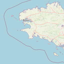
Map view of Réserve naturelle régionale des landes, prairies et étangs de Plounérin

Use this park location map to pinpoint Réserve naturelle régionale des landes, prairies et étangs de Plounérin in France, understand its exact geographic position, and read its mapped placement within the surrounding landscape more clearly.

Pigeon | © OpenStreetMap contributors

Location context for Réserve naturelle régionale des landes, prairies et étangs de Plounérin

Bretagne
Park atlas

Compare surrounding regional nature reserves and connected lowland habitats across inland Brittany

Explore Protected Areas and Parks Near Réserve Naturelle Régionale des Landes, Prairies et Étangs de Plounérin

Browse nearby protected landscapes and related regional reserves sharing similar wetland and heathland geography in the surrounding Breton countryside. Expanding the search reveals how other protected areas preserve comparable semi-natural habitats and rural ecosystems throughout the wider region.
A horizontal watercolor illustration of a soft green landscape with rolling hills, patches of grass, and distant tree lines against a white background.
Nature reserveBretagne
About 14 km away#1 closest

Southwest

Réserve naturelle régionale des landes et tourbières du Cragou et du Vergam: Regional Park Geography

Protected granite ridges and Atlantic peatland ecosystems in Finistère

The Réserve naturelle régionale des landes et tourbières du Cragou et du Vergam stands as a critical reference for understanding Breton upland ecology. Spanning the Monts d'Arrée, these protected sites provide a distinct map of wet heath, acidic flushes, and diverse botanical habitats that define the inland character of northwestern France.

Area
3.434 km²
Established
2008
IUCN
IV
Relief
Upland
Nature reserveFinistère
About 21 km away#2 closest

Southwest

Vallée de l'Aulne Nature Reserve: A Detailed Mapping of Finistère River Valley Geography

Protected riparian landscapes, watershed ecology, and regional basin boundaries

The Vallée de l'Aulne serves as a central artery for the natural landscapes of western France. Spanning from inland Brittany toward the Atlantic, this protected reserve encompasses riverine corridors, bocage terrain, and tidal estuary zones. Use this detailed profile to examine the geographic distribution of protected habitats, river basin features, and the integrated environmental protections that define this key Finistère landscape.

Area
35.64 km²
Established
2014
Relief
Lowland
Climate
Temperate
A watercolor painting showing a wide, panoramic view of a marshy landscape with green clumps of grass in the foreground and soft purple hills in the distance.
Nature reserveFinistère
About 34 km away#3 closest

Southwest

Réserve naturelle nationale du Venec: Protected Peatland and Monts d'Arrée Geography

A core nature reserve and active sphagnum bog ecosystem in Finistère

Located in central Brittany, the Réserve naturelle nationale du Venec represents the only remaining large, active raised bog in the region. This protected area within the Finistère department offers deep insight into the geomorphology of the Yeun-Elez basin, mapping the transition from granite-edged dry moorland through marshy transition zones to the central, ombrotrophic peat dome.

Area
3.341 km²
Established
1993
IUCN
IV
Relief
Upland
A watercolor painting showing a soft, stylized landscape of green hills, marshy fields, and patches of pink wildflowers or heathland against a white background.
Nature reserveBretagne
About 43 km away#4 closest

South

Réserve naturelle régionale des landes et marais de Glomel: Protected Bog and Heathland Atlas

A rare inland wetland refuge within the Bretagne Montagnes Noires

Explore the geographic mosaic of the Réserve naturelle régionale des landes et marais de Glomel, a protected area in Bretagne comprising dual sites of peat bogs, wet heaths, and marshy meadows. This atlas entry details the internal terrain, including the Grazius stream network and the historic canal environment, essential for understanding the habitat distribution and conservation of this distinct inland landscape.

Area
1.078 km²
Established
2008
IUCN
IV
Relief
Upland
A soft watercolor illustration showing a calm coastal bay with distant low hills, green shorelines, and sandy patches under a pale sky.
Nature reserveCôtes-d'Armor
About 64 km away#5 closest

East

Réserve naturelle nationale de la baie de Saint-Brieuc: Coastal Geography and Protected Terrain

Tidal mudflats and salt marshes on the North-Armorican coast.

Located in the Côtes-d'Armor department, this French nature reserve spans over 1,000 hectares of intertidal terrain. The area features a complex mosaic of sandy flats, brackish marshes, and dune systems, providing a critical study of coastal processes and tidal ecosystems along the Brittany shoreline.

Area
11.4 km²
Established
1998
IUCN
IV
Relief
Lowland
A soft, painterly watercolor illustration of a winding river flowing through green marshlands, coastal dunes, and gentle rolling hills under a bright, open sky.
Nature reserveFinistère
About 66 km away#6 closest

West

Réserve naturelle régionale des marais, dunes et baies de Guissény: Protected Atlas Detail

Coastal reserve geography and maritime landscape mapping

Located in Finistère, this protected area features an intricate network of reedbeds, dune ridges, and coastal lagoons. The reserve provides a critical refuge for over 200 bird species and serves as a prime example of the land-and-sea ecological transition characteristic of the northern Breton coastline.

Area
6.083 km²
Established
2025
IUCN
IV
Relief
Lowland
Watercolor painting of soft, rolling green hills and pinkish, jagged coastal cliffs on a white background.
Nature reserveBretagne
About 75 km away#7 closest

Southwest

Réserve naturelle régionale des sites d'intérêt géologique de la presqu'île de Crozon: Protected Area and Atlas

Coastal geological heritage and maritime landscapes in the heart of Bretagne.

Spanning 27 distinct locations, the Réserve naturelle régionale des sites d'intérêt géologique de la presqu'île de Crozon documents millions of years of volcanic, tectonic, and sedimentary evolution. The reserve anchors its scientific value in its open-air exposures of Paleozoic rock, while simultaneously providing a sanctuary for specialized coastal flora and fauna along the Atlantic edge of Bretagne.

Area
1.564 km²
Established
2013
IUCN
IV
Relief
Upland
A soft watercolor painting showing a green landscape with a small pond in the foreground and rolling hills in the background under a pastel sky.
Nature reserveMorbihan
About 90 km away#8 closest

South

Réserve naturelle régionale des étangs du Petit et du Grand Loc'h: Wetland Landscape Atlas

Coastal protected area in Morbihan, Brittany

Located along the Atlantic coast near Guidel, this regional nature reserve protects a vital corridor of freshwater ponds, wet meadows, and reclaimed polders. The area is defined by its complex hydrology and serves as a key refuge for wintering and migratory bird populations within the Morbihan landscape, showcasing the intersection of maritime and terrestrial environments.

Area
1.18 km²
Established
2008
IUCN
IV
Relief
Lowland

Common questions about visiting, size, designation, and location context for Réserve naturelle régionale des landes, prairies et étangs de Plounérin

Réserve naturelle régionale des landes, prairies et étangs de Plounérin FAQs for park facts, access, geography, and protected area context

Find quick answers about Réserve naturelle régionale des landes, prairies et étangs de Plounérin, including protected-area facts, park geography, trail and visitor context, and how the park fits into its surrounding country and regional landscape.
MoriAtlas Explorer

Continue Your Protected Areas Search Across the Global Atlas

Deepen your exploration by continuing the structured search for national parks and protected areas worldwide. Utilize the comprehensive filtering capabilities to compare different conservation landscapes and refine your understanding of global park geography. Discover more about the distribution and characteristics of protected natural areas.

Global natural geography