Mori Atlas logo
Nature reserveRéservoirs de Piraillan

A protected coastal mosaic of nineteenth century saltwater basins and maritime pine islets on the Cap Ferret peninsula.

Réservoirs de Piraillan Nature Reserve: Mapping Coastal Wetlands and Pine Forests in Gironde, France

The Réservoirs de Piraillan represent a compact yet significant protected area on the Cap Ferret peninsula within the Gironde department of southwestern France. This nature reserve preserves a distinct coastal landscape where saline pools and wooded islets of maritime pine create a complex mosaic along the edge of the Bassin d'Arcachon. Through this atlas entry, observe the site's historical fish-reservoir infrastructure, its current ecological role within the Conservatoire du littoral network, and its position as a refuge for birds and small mammals in a heavily humanized environment.

classified natural reservecoastal wetlandsaltwater basinsmaritime pineCap Ferret peninsulaBassin d'Arcachon

Réservoirs de Piraillan

Nature reserve

Park overview

Structured park overview, official facts, and landscape profile for Réservoirs de Piraillan

Réservoirs de Piraillan park facts, protected area profile, and essential visitor context

Review the core facts for Réservoirs de Piraillan, including designation, size, terrain, visitor scale, habitats, and operating context in one park-focused overview.

About Réservoirs de Piraillan

The Réservoirs de Piraillan occupy a distinctive position on the Cap Ferret peninsula, in the commune of Lège-Cap-Ferret, in the Gironde department of the Nouvelle-Aquitaine region. They lie just inland from the Bassin d'Arcachon, between the oyster-farming villages of Piraillan, to the south, and Grand Piquey, to the north. A narrow finger of land, crossed by the D106 road, separates the reservoirs from the bay itself, while a canal with a lock connects the inland waters of the reserve to the tidal rhythms of Arcachon.

In total, the site covers around forty hectares, but only a small proportion of that area is actually open water. Five distinct saltwater basins are scattered among wooded islets planted with maritime pine, the dominant tree of the Aquitaine coast. The result is a fragmented but interconnected landscape in which pine forest, saline water, and tidal influence meet in an unusually compact setting.

Beyond its ecological interest, the reserve carries the imprint of more than a century of human activity on the peninsula. Its basins were originally created in the late nineteenth century as fish reservoirs by the Lesca brothers, landowners who reshaped much of northern Cap Ferret. After the site was classified in 1943, a descendant of the family opened a campsite there in the 1960s. Eventually the property was sold to the French state in 1975, rehabilitated by the commune in 1995, and entrusted to the Conservatoire du littoral in 1996, putting an end to a long period of private use and placing it firmly within France's coastal protection framework.

Today the Réservoirs de Piraillan function as a quiet but ecologically important counterpoint to the bustling oyster ports and beaches that surround them. Walking circuits let visitors discover this compact patchwork of water and pine, while the islets themselves remain off-limits to protect the wildlife they shelter.

Quick facts and research context for Réservoirs de Piraillan

The Réservoirs de Piraillan form a classified natural reserve of about forty hectares on the Cap Ferret peninsula, in the Gironde department of southwestern France. They are made up of roughly five hectares of saltwater basins surrounding wooded islets planted with maritime pine. The site is connected to the Bassin d'Arcachon by a canal closed off by a lock, and a department road (the D106) runs along the thin strip of land that separates the reservoirs from the bay. Classified as a natural site in 1943, the property became state-owned in 1975 and was entrusted to the Conservatoire du littoral in 1996 for long-term protection.

Protection and recognition

Documented terrestrial protection scope and historical designation data

Réservoirs de Piraillan Protection Status and Designation History

Historical records establish the terrestrial protection status and designation year of 1943 for Réservoirs de Piraillan. Structured regulatory details provide a clear framework for examining management scope and recognized conservation boundaries.

Protection details

Protection scope
Terrestrial
Designated year
1943
Transboundary protection
No
Park context

Deeper park guide and search-rich context for Réservoirs de Piraillan

Réservoirs de Piraillan history, landscape, wildlife, and travel context

Explore Réservoirs de Piraillan through its history, landscape character, ecosystems, wildlife, conservation priorities, cultural context, and seasonal travel timing in a structured park guide built for atlas discovery and search intent.

Why Réservoirs de Piraillan stands out

The Réservoirs de Piraillan are best known for the unusual contrast they create within the Cap Ferret peninsula: brackish-to-saline open water sitting right beside dense stands of maritime pine, on a coastal strip otherwise shaped by oyster farming and summer tourism. Their ecological reputation rests on this small but unusually diverse coastal habitat. Birds, insects, fish, and small mammals share a landscape of saltwater pools and wooded islets, while the historical dimension of nineteenth-century fish reservoirs and twentieth-century conservation gives the site a layered cultural character that complements its natural value.

Réservoirs de Piraillan history and protected-area timeline

The history of the Réservoirs de Piraillan begins in the late nineteenth century, when Léon Lesca and his brother Frédéric, landowners on the Cap Ferret peninsula, transformed a natural coastal depression into a series of fish reservoirs. Using the site's natural setting and a connection to the Bassin d'Arcachon, the Lesca brothers created saltwater basins that became part of the broader nineteenth-century reshaping of the peninsula.

The site was formally classified as a natural area in 1943, an early recognition of its ecological value, but the property remained in private hands for several more decades. In the 1960s, a descendant of the Lesca family opened a campsite on the site, introducing tourism into what had been an essentially landscape and heritage site.

A decisive turning point came in 1975, when the property was sold to the French state. The commune of Lège-Cap-Ferret undertook a rehabilitation of the area in 1995, and one year later, in 1996, the state transferred the site to the Conservatoire du littoral. Since then the reserve has been managed by the commune on behalf of the Conservatoire, marking its transition from a privately exploited coastal site to a long-term protected natural area.

Réservoirs de Piraillan landscape and geographic character

The landscape of the Réservoirs de Piraillan is defined by the interplay between water and pine forest on a narrow coastal strip. The site consists of multiple shallow saltwater basins set among low islets planted with maritime pine, the iconic tree of the Aquitaine littoral. Roughly forty hectares in total, with only five hectares of open water, the reserve sits behind a thin strip of land that runs along the Bassin d'Arcachon.

A canal with a lock links the reservoirs to the bay, tying the site into the larger tidal system of Arcachon. The D106 road traces the boundary between this inland mosaic of pools and pine and the open waters of the bay beyond. The result is a layered coastal terrain: saltwater basins, pine-covered islands, marshy edges, sandy soil, and the much larger marine horizon of the basin itself.

Although small, the reserve is visually striking because of how sharply the dark pine masses contrast with the reflective surfaces of the saline pools, all within a heavily humanized landscape shaped by oyster ports, villages, and seasonal tourism.

Réservoirs de Piraillan ecosystems, habitats, and plant life

Ecologically, the Réservoirs de Piraillan are notable for the concentration of habitats packed into a very small area. The combination of saltwater basins, vegetated islets, and surrounding pine forest creates a succession of micro-environments, from open water and muddy banks through shrubby edges to mature pine cover.

The saline character of the pools, inherited from their connection to the Bassin d'Arcachon, supports vegetation and invertebrates adapted to brackish conditions, while the maritime pines anchor a typical Aquitaine coastal forest. The mosaic structure is particularly favorable for species that move between water and forest, and the relative tranquility of the protected site enhances its role as a refuge within an otherwise densely populated peninsula.

Although compact, the reserve functions as a representative sample of the layered coastal ecosystems that characterize the Gironde shoreline, where marine influence, forested dune landscapes, and human land use converge.

Réservoirs de Piraillan wildlife and species highlights

The Réservoirs de Piraillan shelter a rich community of wildlife for so small a site. The mix of saltwater pools and pine-covered islets provides habitat for birds, insects, fish, and small mammals, with the saline basins attracting aquatic and shore-loving species while the wooded areas host more terrestrial fauna.

The connection to the Bassin d'Arcachon through the canal means that the reserve shares in the broader ecological dynamics of the bay, including seasonal movements of fish and birds. Even though the islets themselves are not accessible to visitors, the surrounding banks and shores remain productive feeding and resting areas, particularly for birdlife associated with coastal wetlands and the lagoon-like edges of the basin.

Réservoirs de Piraillan conservation status and protection priorities

The Réservoirs de Piraillan have been part of France's protected-area system since 1943, when they were classified as a natural site. Their conservation value lies in the unusually dense mosaic of saline pools and pine islands preserved within a heavily developed coastal peninsula.

The transfer of the property to the Conservatoire du littoral in 1996 placed the reserve within a national framework specifically aimed at safeguarding fragile coastal landscapes. Today the Conservatoire holds the site while the commune of Lège-Cap-Ferret handles day-to-day management, including visitor access and habitat upkeep.

Restricting access to the islets, channeling visitors along marked walking circuits, and preserving the saline character of the pools are central to the site's conservation strategy, ensuring that the reserve continues to function as a refuge within the larger Arcachon coastal system.

Réservoirs de Piraillan cultural meaning and human context

The cultural dimension of the Réservoirs de Piraillan is closely tied to the identity of the Cap Ferret peninsula. The site was created by the Lesca brothers during the same late-nineteenth-century wave of land improvement that shaped much of the oyster-farming and tourism coast of Arcachon, and it carries the imprint of that pioneering generation of landowners.

The brief history of a family-run campsite in the 1960s reflects the broader story of the peninsula as a summer destination, while the eventual passage of the site into state ownership and then to the Conservatoire du littoral illustrates the gradual shift of the Cap Ferret coast from private exploitation to collective stewardship. Surrounding villages such as Piraillan and Grand Piquey, both oyster ports and seasonal resorts, frame the reserve within a deeply rooted regional culture of maritime work and seaside leisure.

Top sights and standout views in Réservoirs de Piraillan

A compact yet ecologically rich classified natural reserve at the heart of the Cap Ferret peninsula, where saltwater basins and maritime pine islands coexist within walking distance of the Bassin d'Arcachon. The site combines nineteenth-century fish-reservoir heritage with a protected status held since 1943 and a modern role within the Conservatoire du littoral network. Two short walking circuits allow visitors to discover the contrast between pond, pine, and bay without disturbing the wildlife-rich islets.

Best time to visit Réservoirs de Piraillan

Spring and early summer are widely considered favorable periods to appreciate the reservoirs, when bird activity around the saltwater basins and the surrounding pine forest is at its richest, and the temperatures on the Cap Ferret peninsula remain mild. Early autumn can also be rewarding, as bird movements on the Bassin d'Arcachon intensify and the light over the pools becomes softer.

The site is more exposed to summer crowds in the surrounding villages of Piraillan and Grand Piquey, so quieter shoulder seasons often suit visitors more interested in the natural character of the reserve than in the busier atmosphere of the oyster ports. Winter visits remain possible, though the weather on the Atlantic coast can be wet and windy, and the visual contrast between pines, water, and sky becomes more austere.

Monthly climate preview

Long term temperature and precipitation patterns across the protected landscape

Réservoirs de Piraillan climate and monthly temperature normals

Historical climate records from 1991 to 2020 outline monthly temperature ranges and precipitation rates measured at representative coordinates in Gironde. Examining the full twelve month profile provides deeper insight into long term environmental rhythms and baseline averages across the protected area.
Annual mean14 °C
9 °C21 °C
Jan
Feb
Mar11°
Apr12°
May16°
Jun19°
Jul21°
Aug21°
Sep19°
Oct16°
Nov12°
Dec
Warmest month
August

21.2 °C

Coolest month
January

8.5 °C

Wettest month
November

4.4 mm/day

Driest month
July

1.4 mm/day

Park location guide

Geography guide, regional context, and park location map for Réservoirs de Piraillan

Réservoirs de Piraillan park geography, regions, and map view in France

Understand where Réservoirs de Piraillan sits in France through a broader geographic reading of the surrounding landscape, nearby location context, and its mapped position within the national park landscape.

How Réservoirs de Piraillan fits into France

France is a unitary semi-presidential republic and one of the world's largest economies. It borders Belgium, Luxembourg, Germany, Switzerland, Italy, Monaco, Andorra, and Spain, with a maritime border to the United Kingdom. The country is known for its cultural influence, art, cuisine, and political history spanning centuries.

Wider geography shaping Réservoirs de Piraillan in France

France is located in Western Europe. Metropolitan France extends from the Rhine to the Atlantic Ocean and from the Mediterranean Sea to the English Channel and North Sea. The country borders Belgium, Luxembourg, Germany, Switzerland, Italy, Monaco, Andorra, Spain, and has a maritime border with the United Kingdom.

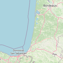
Map view of Réservoirs de Piraillan

Use this park location map to pinpoint Réservoirs de Piraillan in France, understand its exact geographic position, and read its mapped placement within the surrounding landscape more clearly.

Pigeon | © OpenStreetMap contributors

Location context for Réservoirs de Piraillan

Gironde
Park atlas

Compare regional coastal wetlands and maritime pine reserves

Other Parks and Protected Areas Near Réservoirs de Piraillan

Browse protected areas and coastal reserves situated near Réservoirs de Piraillan to examine wider regional geography. Regional park comparison reveals broader ecological patterns across southwestern wetland landscapes.
Nature reserveNouvelle-Aquitaine
About 51 km away#1 closest

East

Réserve naturelle nationale géologique de Saucats et la Brède: Geological Nature Reserve Atlas

Protected strata and Miocene fossil landscapes in Nouvelle-Aquitaine

This protected area serves as a primary European reference site for Cenozoic geology. It features distinct Miocene marine sand outcrops, fossil-rich faluns, and stream-cut sections that reveal the complex history of the Aquitaine Basin across multiple geographic sectors.

Area
0.755 km²
Established
1982
IUCN
III
Wildlife reserveNouvelle-Aquitaine
About 76 km away#2 closest

Northeast

Terres d'oiseaux Wildlife Reserve: Protected Estuarine Landscape in Nouvelle-Aquitaine

Migratory bird habitat and Gironde estuary geography

Terres d'oiseaux is a significant wildlife reserve positioned within the Blayais marshes of Nouvelle-Aquitaine. The site encompasses a diverse mosaic of estuarine wetlands, including reedbeds and open water, providing critical stopover habitat for migratory birds along the Atlantic flyway. Its geography represents a blend of tidal interaction and controlled natural management, essential for regional avian monitoring and ecological studies.

Area
1.2 km²
Established
2010
IUCN
IV
Relief
Lowland
Protected areaNouvelle-Aquitaine
About 112 km away#3 closest

Northeast

Vallée de la Tude Protected Area: Regional Geography and Alluvial Landscape Map

Exploring the river valley networks of Nouvelle-Aquitaine

The Vallée de la Tude is a significant protected area located in the Charente department of southwestern France. This site features a series of wet meadows, lowland brooks, and woodland fragments that form an essential ecological network. Our atlas entry provides a detailed look at the geographic distribution and landscape composition of this unique alluvial valley.

Area
15.57 km²
Established
2006
Relief
Upland
Climate
Temperate
A soft watercolor illustration showing rolling green hills, patches of trees, and a distant horizon in shades of light green and pale yellow.
Nature reserveNouvelle-Aquitaine
About 115 km away#4 closest

South

Réserve naturelle régionale du site des carrières de Tercis-les-Bains Protected Landscape

Geological stratotype and Cretaceous fossil reference site in Nouvelle-Aquitaine

This unique nature reserve in southwestern France protects a globally significant Cretaceous geological sequence within former limestone quarries. It serves as a vital scientific landmark for stratigraphy, housing extensive fossil records and structural evidence of salt-driven geology, all set within the scenic terrain of the Adour river basin.

Area
0.448 km²
Established
2015
IUCN
IV
Relief
Lowland
Nature reserveNouvelle-Aquitaine
About 120 km away#5 closest

North

Réserve naturelle régionale de la Massonne: Geographic Atlas and Protected Area Map

Mapped ecosystems within the Nouvelle-Aquitaine marshlands

Réserve naturelle régionale de la Massonne serves as a significant ecological corridor in western France, defined by its abrupt transition from coastal Brouage marshes to acidic heath. This atlas entry provides essential data on the reserve boundaries, mapped terrain types, and the structural diversity of its protected wetlands and shrublands, highlighting its role as a sanctuary for diverse nocturnal fauna.

Area
2.023 km²
Established
1997
IUCN
IV
Relief
Lowland
Nature reserveNouvelle-Aquitaine
About 127 km away#6 closest

Northeast

Vallée de l'Antenne: A Protected River Valley and Alluvial Landscape in Nouvelle-Aquitaine

Mapping riparian ecosystems and rare wetland habitats

Trace the course of the Antenne river as it meanders through a finely textured mosaic of ash and alder forests, poplar plantations, and floodplains. As a designated Natura 2000 site, this nature reserve acts as a critical refuge for biodiversity in western France, offering a textbook example of a low-energy river system that descends gently through the landscape of the Charente departments.

Area
12.08 km²
Established
1999
Relief
Lowland
Climate
Mediterranean
Nature reserveNouvelle-Aquitaine
About 134 km away#7 closest

Northeast

Vallée de la Nizonne Nature Reserve: Mapped Geography and Protected Wetland Landscapes

A critical river corridor and Natura 2000 conservation zone in Nouvelle-Aquitaine.

Discover the geographic structure of the Vallée de la Nizonne, a protected area shaped by the flow of the Nizonne and Lizonne rivers. This landscape mosaic features peatlands, wet meadows, and alluvial forests that serve as a refuge for rare species. Gain insight into the regional terrain and conservation boundaries that define this important French wetland corridor.

Area
33.91 km²
Established
2016
Relief
Upland
Climate
Temperate
Nature reserveNouvelle-Aquitaine
About 146 km away#8 closest

South

Réserve naturelle régionale d'Errota Handia: Protected Wetland and Basque Geographic Atlas

Examining the ecological terrain of a historic French millpond reserve

Explore the structured geography of Réserve naturelle régionale d'Errota Handia, a compact but ecologically significant nature reserve in the Pyrénées-Atlantiques. This resource provides a detailed look at the park boundaries, wetland-woodland mosaic, and the historic hydraulic infrastructure that defines this unique Basque landscape, offering an essential perspective for understanding regional conservation in southwestern France.

Area
0.095 km²
Established
2001
IUCN
IV

Common questions about visiting, size, designation, and location context for Réservoirs de Piraillan

Réservoirs de Piraillan FAQs for park facts, access, geography, and protected area context

Find quick answers about Réservoirs de Piraillan, including protected-area facts, park geography, trail and visitor context, and how the park fits into its surrounding country and regional landscape.
MoriAtlas Explorer

Continue Your Protected Areas Search Across the Global Atlas

Deepen your exploration by continuing the structured search for national parks and protected areas worldwide. Utilize the comprehensive filtering capabilities to compare different conservation landscapes and refine your understanding of global park geography. Discover more about the distribution and characteristics of protected natural areas.

Global natural geography