Mori Atlas logo
Nature reserveRéserve naturelle nationale géologique de Saucats et la Brède

Tracing Miocene marine deposits and fossiliferous strata within the Nouvelle-Aquitaine region

Réserve naturelle nationale géologique de Saucats et la Brède: Geological Protected Landscapes

(Réserve naturelle nationale géologique de Saucats et La Brède)

The Réserve naturelle nationale géologique de Saucats et la Brède stands as a landmark protected area within the Nouvelle-Aquitaine landscape of France. Established as the nation's first geological nature reserve, it provides essential stratigraphic context through its exposed falun deposits. Visitors and researchers use these mapped sites to study successive Miocene marine incursions, paleontological heritage, and riparian ecosystems shaped by the Saucats and Brousteyrot streams.

geological reservefalun outcropsMiocene fossilsstratotype siteriparian habitatpaleontological heritage

Réserve naturelle nationale géologique de Saucats et la Brède

Nature reserve

Park overview

Structured park overview, official facts, and landscape profile for Saucats and La Brède National Geological Nature Reserve

Saucats and La Brède National Geological Nature Reserve park facts, protected area profile, and essential visitor context

Review the core facts for Saucats and La Brède National Geological Nature Reserve, including designation, size, terrain, visitor scale, habitats, and operating context in one park-focused overview.

About Saucats and La Brède National Geological Nature Reserve

The Saucats and La Brède National Geological Nature Reserve occupies a small but scientifically significant footprint in southwestern France, within the Gironde department of the Nouvelle-Aquitaine region. Situated at the edge of the Landes forest and only about twenty kilometers south of Bordeaux, the reserve covers approximately 75.5 hectares distributed across six separate sites on the communes of Saucats and La Brède. These sites, grouped into three geographic sectors, were chosen specifically to protect continuous geological outcrops that would otherwise be vulnerable to erosion, vegetation overgrowth, or unregulated fossil collecting.

The defining feature of the reserve is its series of fossil-bearing Cenozoic deposits, particularly the faluns. Faluns are consolidated shell sands formed from the remains of marine organisms, and the local exposures record three separate marine transgressions into the Aquitaine Basin during the early to middle Miocene. These deposits correspond to the Aquitanian, Burdigalian, and Serravallian stages and span roughly twelve million years of geological history. Two of the stages, the Aquitanian defined by Charles Mayer in 1858 and parts of the Burdigalian defined by Charles Depéret in 1892, have their official stratotypes within the reserve, giving it a global reference value that extends well beyond regional interest.

Beyond its paleontological importance, the reserve exhibits a close relationship between its geological substrates and its living environment. The fossil-bearing layers are exposed along narrow valleys carved by the Saucats stream and its tributary the Brousteyrot, creating small gorges and cliff faces where the stratigraphy is directly visible. These valleys also harbor riparian woodland, wetland vegetation, and fauna adapted to humid conditions, so that protection of the geological heritage indirectly safeguards a network of natural habitats. The combination of reference geological sections and functioning ecosystems makes the site a notable example of integrated natural heritage management in France.

Protection and recognition

Examine documented protected area designation metrics and official records

Protection Status and International Recognition for Réserve naturelle nationale géologique de Saucats et la Brède

Comprehensive protected area designation data for Réserve naturelle nationale géologique de Saucats et la Brède provides clear reference points for conservation status. Global database records track administrative identifiers to support detailed geographical research.

Protection details

WDPA ID
39786
Park context

Deeper park guide and search-rich context for Saucats and La Brède National Geological Nature Reserve

Saucats and La Brède National Geological Nature Reserve history, landscape, wildlife, and travel context

Explore Saucats and La Brède National Geological Nature Reserve through its history, landscape character, ecosystems, wildlife, conservation priorities, cultural context, and seasonal travel timing in a structured park guide built for atlas discovery and search intent.

Why Saucats and La Brède National Geological Nature Reserve stands out

The reserve is best known as the type locality and reference section for the Aquitanian stage and elements of the Burdigalian stage of the Miocene, making it a cornerstone site for European stratigraphy and Cenozoic paleontology. Its falun outcrops, fossilized shell sand deposits from successive marine incursions into the Aquitaine Basin, are internationally cited in geological literature. The site is also recognized as the first national geological nature reserve created in France.
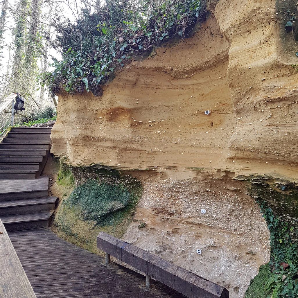
A wooden boardwalk leads along the base of a tan, layered sedimentary cliff wall with numbered markers indicating different geological strata.
The Pont-Pourquey geological cliff site, featuring marked stratigraphic layers.

Saucats and La Brède National Geological Nature Reserve history and protected-area timeline

The geological significance of the Saucats and La Brède area was recognized long before formal protection. Beginning in the nineteenth century, the falun outcrops along the Saucats and Brousteyrot streams attracted the attention of prominent geologists and paleontologists, including Charles Mayer, who established the Aquitanian stage in 1858, and Charles Depéret, who established the Burdigalian stage in 1892. Throughout the late nineteenth and twentieth centuries, researchers such as Benoist, Degrange-Touzin, Maurice Cossmann, Peyrot, and Daguin conducted extensive studies at the sites, and amateur collectors also gathered fossils, gradually increasing pressure on the exposures.

In 1980, concerned about both the scientific value and the vulnerability of these outcrops, local actors founded the Association pour la réserve géologique de Saucats and La Brède with the explicit aim of protecting the geological heritage and promoting public discovery of the site. Their efforts led, in 1982, to the creation of France's first national geological nature reserve by ministerial decree on 5 September 1982. The reserve was thus established not only as a conservation measure but also as a milestone in French natural heritage policy, opening the way for later geological reserves elsewhere in the country.

Since its creation, the reserve has been managed by a dedicated association that oversees scientific monitoring, site maintenance, public outreach, and visitor programming. Educational facilities, open-air museum sections, and interpretive panels have been developed at key sites, allowing visitors to engage directly with the geological features while ongoing research continues to refine the stratigraphic understanding of the area.

Saucats and La Brède National Geological Nature Reserve landscape and geographic character

The landscape of the reserve is shaped by a subtle interaction between flat regional terrain and the incision of small streams. The broader area lies within the Landes forest region, characterized by relatively level ground, but the reserve itself focuses on narrow valleys cut by the Saucats stream and its tributary the Brousteyrot. These valleys reveal cliff faces, exposed banks, and natural sections where Miocene sediments are directly visible, producing dramatic small-scale relief within an otherwise subdued regional landscape.

The fossil-bearing formations are expressed as faluns, consolidated shell sands that weather into distinctive light-colored outcrops. Where the streams have undercut these formations, small cliffs and escarpments such as the Pont-Pourquey exposure stand along the watercourses, providing textbook examples of stratigraphic layering in compact, easily readable form. Three sectors group these exposures, each corresponding roughly to one Miocene stage and giving the visitor a sense of stepping through geological time across relatively short distances.

Saucats and La Brède National Geological Nature Reserve ecosystems, habitats, and plant life

Although the reserve is primarily valued for its geology, its ecological character is closely tied to the same features that expose the fossils. The streams that cut through the falun deposits create narrow, sheltered valleys with persistent moisture, supporting riparian woodland, marshy vegetation, and bryophyte-rich microhabitats. Alder-dominated riparian forests line the watercourses, accompanied by marshland plants such as yellow flag iris and marsh marigold, which thrive in the saturated soils near the exposed formations.

The variety of small-scale environments within these valleys produces notable habitat diversity for such a compact site. Shaded cliff faces, seepage zones, wet meadows, and stream margins each contribute distinct microclimates. The Bernachon site in particular is recognized for its rich bryophyte communities, reflecting the humid conditions and stable substrates maintained along the geological outcrops. This combination of geology and hydrology gives the reserve an ecological profile that is more diverse than its modest size would suggest.

Saucats and La Brède National Geological Nature Reserve wildlife and species highlights

The fauna of the reserve reflects the riparian and wetland habitats that fringe the geological exposures. Mammals documented in the area include the European mink, a species of significant conservation interest, and the common genet, which finds refuge in the wooded stream corridors. Birds are well represented along the streams, with the European kingfisher, the grey wagtail, and the firecrest among the characteristic species, all dependent on the aquatic and woodland edge environments.

Amphibians are an important component of the reserve's wildlife, notably the fire salamander and the marbled newt, both of which depend on the clean, sheltered stream systems. The presence of these sensitive species underscores the ecological value of the small valley environments that the reserve conserves alongside its geological assets. Although the site is small, the concentration of stream-associated species adds meaningful biodiversity to its primarily geological mission.

Saucats and La Brède National Geological Nature Reserve conservation status and protection priorities

The conservation significance of the Saucats and La Brède reserve rests on its role as a protected reference section for international stratigraphy. By safeguarding the physical outcrops that define the Aquitanian and parts of the Burdigalian stages, the reserve ensures that these globally recognized geological benchmarks remain accessible for scientific study, correlation, and teaching. This function extends well beyond French borders, as stratotypes are reference points used by geologists worldwide.

The reserve also illustrates an early and successful model of geological heritage protection in France. Created decades before geological conservation became a widespread practice, it demonstrated that fragile fossil exposures could be legally protected, managed by a dedicated association, and opened to the public without compromising their scientific integrity. The regulation of fossil collecting, control of vegetation overgrowth on outcrops, and provision of managed visitor access all reflect a careful balance between conservation, research, and public engagement.

At a landscape level, the reserve conserves a network of small valleys and associated ecosystems that would otherwise be subject to gradual degradation. By protecting the geological exposures and the surrounding riparian habitat together, the reserve preserves an integrated natural system in which the geological substrate and the living environment reinforce one another.

Saucats and La Brède National Geological Nature Reserve cultural meaning and human context

The reserve carries a strong scientific and cultural heritage rooted in nineteenth-century geological research. The Aquitanian stage, named after the historical Aquitaine region that includes the reserve's location, was coined by the Swiss geologist Charles Mayer in 1858 based directly on observations at these outcrops. This naming reflects a broader nineteenth-century European practice of defining geological stages using local type localities, giving the region a lasting place in the international geological vocabulary.

Local engagement has been central to the reserve's identity since its creation. The founding of a local association in 1980, two years before the official designation, illustrates a community-driven effort to defend both scientific heritage and regional identity. Educational programming, on-site museums, and guided visits have since embedded the reserve into the cultural life of the Gironde, offering residents and visitors a direct connection to the deep-time history written in the local landscape.

Top sights and standout views in Saucats and La Brède National Geological Nature Reserve

The reserve's defining highlights include its status as the type locality for the Aquitanian stage and parts of the Burdigalian stage, its pioneering role as the first national geological nature reserve in France, and the visibility of three successive Miocene marine transgressions recorded in its falun outcrops. Visitors can encounter dramatic small-scale cliff sections along the Saucats and Brousteyrot streams, open-air site museums at Bernachon, l'Ariey, Péloua, la Bourasse, Pont-Pourquey, and Lassime, and an unusually rich bryophyte and riparian community sustained by the same exposures that make the geology accessible.

Best time to visit Saucats and La Brède National Geological Nature Reserve

The reserve can be visited year-round, but spring and early autumn are generally the most rewarding seasons for combining geological observation with comfortable walking conditions and active wildlife. Mild weather in these periods makes it easier to read the outcrops along the streams and to appreciate the surrounding riparian vegetation at its most expressive. Summer visits offer long daylight hours and lively insect and amphibian activity, while the quieter winter months can bring softer light on the cliff faces and fewer visitors, allowing more contemplative study of the stratigraphic exposures.
Monthly climate preview

Long term temperature ranges and precipitation averages across twelve measured months

Annual Climate Normals and Weather Patterns at Réserve naturelle nationale géologique de Saucats et la Brède

Long term baseline data reveals moderate thermal shifts and steady monthly precipitation across the sampled coordinate within Réserve naturelle nationale géologique de Saucats et la Brède. Reviewing the complete twelve month temperature and precipitation profile provides detailed context for regional climatic conditions.
Annual mean13 °C
6 °C21 °C
Jan
Feb
Mar10°
Apr12°
May16°
Jun19°
Jul21°
Aug21°
Sep18°
Oct14°
Nov
Dec
Warmest month
August

21.4 °C

Coolest month
January

5.8 °C

Wettest month
November

3.3 mm/day

Driest month
July

1.5 mm/day

Park location guide

Geography guide, regional context, and park location map for Saucats and La Brède National Geological Nature Reserve

Saucats and La Brède National Geological Nature Reserve park geography, regions, and map view in France

Understand where Saucats and La Brède National Geological Nature Reserve sits in France through a broader geographic reading of the surrounding landscape, nearby location context, and its mapped position within the national park landscape.

How Saucats and La Brède National Geological Nature Reserve fits into France

France is a unitary semi-presidential republic and one of the world's largest economies. It borders Belgium, Luxembourg, Germany, Switzerland, Italy, Monaco, Andorra, and Spain, with a maritime border to the United Kingdom. The country is known for its cultural influence, art, cuisine, and political history spanning centuries.

Wider geography shaping Saucats and La Brède National Geological Nature Reserve in France

France is located in Western Europe. Metropolitan France extends from the Rhine to the Atlantic Ocean and from the Mediterranean Sea to the English Channel and North Sea. The country borders Belgium, Luxembourg, Germany, Switzerland, Italy, Monaco, Andorra, Spain, and has a maritime border with the United Kingdom.

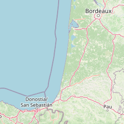
Map view of Saucats and La Brède National Geological Nature Reserve

Use this park location map to pinpoint Saucats and La Brède National Geological Nature Reserve in France, understand its exact geographic position, and read its mapped placement within the surrounding landscape more clearly.

Pigeon | © OpenStreetMap contributors

Location context for Saucats and La Brède National Geological Nature Reserve

Nouvelle-Aquitaine

Visual reference of protected geological outcrops, fossilized falun layers, and riparian habitats

Exploring Réserve naturelle nationale géologique de Saucats et la Brède Photos and Landscape Scenery

Visual records capture the distinctive terrain, exposed shell sand cliffs, and protected stream valleys defining Réserve naturelle nationale géologique de Saucats et la Brède. Examining these authentic environmental photographs reveals the geological formations and regional landscape character of this protected area.

A wooden boardwalk leads along the base of a tan, layered sedimentary cliff wall with numbered markers indicating different geological strata.

A high-angle, close-up shot of light-colored, weathered fossilized shells and marine remnants embedded in sandy sediment.

Park atlas

Compare surrounding protected landscapes and neighboring reserves across the regional terrain

Parks Near Réserve Naturelle Nationale Géologique de Saucats et la Brède and Regional Protected Areas

Browsing other protected areas near Réserve naturelle nationale géologique de Saucats et la Brède reveals broader regional geography and connected natural terrain. Extending the search helps visitors compare similar protected landscapes and geological formations across the surrounding territory.
Nature reserveGironde
About 51 km away#1 closest

West

Réservoirs de Piraillan Nature Reserve: Mapping the Coastal Ecology of the Cap Ferret Peninsula

A protected mosaic of saltwater basins and pine-forested islets in Gironde.

Explore the structured geography of Réservoirs de Piraillan, a forty-hectare classified natural reserve situated on the Cap Ferret peninsula in southwestern France. This site offers a rare contrast between historical fish reservoirs and dense maritime pine forest, providing a protected habitat for diverse bird and insect populations adjacent to the Bassin d'Arcachon. Understand the interplay between these saltwater pools and the wider coastal terrain of the Gironde department through detailed mapping and landscape data.

Area
0.4 km²
Established
1943
Relief
Lowland
Climate
Mediterranean
Wildlife reserveNouvelle-Aquitaine
About 65 km away#2 closest

North

Terres d'oiseaux Wildlife Reserve: Protected Estuarine Landscape in Nouvelle-Aquitaine

Migratory bird habitat and Gironde estuary geography

Terres d'oiseaux is a significant wildlife reserve positioned within the Blayais marshes of Nouvelle-Aquitaine. The site encompasses a diverse mosaic of estuarine wetlands, including reedbeds and open water, providing critical stopover habitat for migratory birds along the Atlantic flyway. Its geography represents a blend of tidal interaction and controlled natural management, essential for regional avian monitoring and ecological studies.

Area
1.2 km²
Established
2010
IUCN
IV
Relief
Lowland
Protected areaNouvelle-Aquitaine
About 76 km away#3 closest

Northeast

Vallée de la Tude Protected Area: Regional Geography and Alluvial Landscape Map

Exploring the river valley networks of Nouvelle-Aquitaine

The Vallée de la Tude is a significant protected area located in the Charente department of southwestern France. This site features a series of wet meadows, lowland brooks, and woodland fragments that form an essential ecological network. Our atlas entry provides a detailed look at the geographic distribution and landscape composition of this unique alluvial valley.

Area
15.57 km²
Established
2006
Relief
Upland
Climate
Temperate
Nature reserveNouvelle-Aquitaine
About 97 km away#4 closest

Northeast

Vallée de la Nizonne Nature Reserve: Mapped Geography and Protected Wetland Landscapes

A critical river corridor and Natura 2000 conservation zone in Nouvelle-Aquitaine.

Discover the geographic structure of the Vallée de la Nizonne, a protected area shaped by the flow of the Nizonne and Lizonne rivers. This landscape mosaic features peatlands, wet meadows, and alluvial forests that serve as a refuge for rare species. Gain insight into the regional terrain and conservation boundaries that define this important French wetland corridor.

Area
33.91 km²
Established
2016
Relief
Upland
Climate
Temperate
A soft, painterly watercolor illustration of a river landscape with lush green trees on the banks and rolling hills in the background.
Nature reserveFrance
About 108 km away#5 closest

Southeast

Réserve naturelle nationale de la frayère d'Alose: Garonne River Protected Area Mapping

Analyzing aquatic terrain and migratory fish spawning grounds in France

Located in the Lot-et-Garonne department, the Réserve naturelle nationale de la frayère d'Alose comprises a unique, ecologically defined segment of the Garonne River. The reserve manages specific riverbed substrates and current patterns to maintain critical habitats for endangered anadromous species. Its role extends beyond simple protection, acting as a vital reference area for ecological research into the health of river-based migratory fish corridors across the region.

Area
0.478 km²
Established
1981
Relief
Lowland
Climate
Temperate
Nature reserveNouvelle-Aquitaine
About 114 km away#6 closest

North

Vallée de l'Antenne: A Protected River Valley and Alluvial Landscape in Nouvelle-Aquitaine

Mapping riparian ecosystems and rare wetland habitats

Trace the course of the Antenne river as it meanders through a finely textured mosaic of ash and alder forests, poplar plantations, and floodplains. As a designated Natura 2000 site, this nature reserve acts as a critical refuge for biodiversity in western France, offering a textbook example of a low-energy river system that descends gently through the landscape of the Charente departments.

Area
12.08 km²
Established
1999
Relief
Lowland
Climate
Mediterranean
A soft watercolor illustration showing rolling green hills, patches of trees, and a distant horizon in shades of light green and pale yellow.
Nature reserveNouvelle-Aquitaine
About 118 km away#7 closest

South

Réserve naturelle régionale du site des carrières de Tercis-les-Bains Protected Landscape

Geological stratotype and Cretaceous fossil reference site in Nouvelle-Aquitaine

This unique nature reserve in southwestern France protects a globally significant Cretaceous geological sequence within former limestone quarries. It serves as a vital scientific landmark for stratigraphy, housing extensive fossil records and structural evidence of salt-driven geology, all set within the scenic terrain of the Adour river basin.

Area
0.448 km²
Established
2015
IUCN
IV
Relief
Lowland
Nature reserveNouvelle-Aquitaine
About 127 km away#8 closest

North

Réserve naturelle régionale de la Massonne: Geographic Atlas and Protected Area Map

Mapped ecosystems within the Nouvelle-Aquitaine marshlands

Réserve naturelle régionale de la Massonne serves as a significant ecological corridor in western France, defined by its abrupt transition from coastal Brouage marshes to acidic heath. This atlas entry provides essential data on the reserve boundaries, mapped terrain types, and the structural diversity of its protected wetlands and shrublands, highlighting its role as a sanctuary for diverse nocturnal fauna.

Area
2.023 km²
Established
1997
IUCN
IV
Relief
Lowland

Common questions about visiting, size, designation, and location context for Saucats and La Brède National Geological Nature Reserve

Saucats and La Brède National Geological Nature Reserve FAQs for park facts, access, geography, and protected area context

Find quick answers about Saucats and La Brède National Geological Nature Reserve, including protected-area facts, park geography, trail and visitor context, and how the park fits into its surrounding country and regional landscape.
MoriAtlas Explorer

Continue Your Protected Areas Search Across the Global Atlas

Deepen your exploration by continuing the structured search for national parks and protected areas worldwide. Utilize the comprehensive filtering capabilities to compare different conservation landscapes and refine your understanding of global park geography. Discover more about the distribution and characteristics of protected natural areas.

Global natural geography