Mori Atlas logo
Nature reserveRiemeisterfenn

Mapping a rare lowland peat bog ecosystem within the historic Grunewald forest boundary

Riemeisterfenn Nature Reserve and the Hydrological Landscape of Southwestern Berlin

(Naturschutzgebiet Riemeisterfenn)

Riemeisterfenn serves as a critical nature reserve in Berlin, protecting a fragile, boggy lowland that stands as a remnant of the region's original natural vegetation. Situated along the Grunewaldseenkette, this wetland area showcases the complex interplay between glacial topography and urban water management. Users can examine how this peatland habitat functions as a rare, nutrient-poor ecosystem, preserved against the pressures of surrounding urban development.

urban wetlandpeatland reservebogmooraldersGrunewald

Riemeisterfenn

Nature reserve

Park overview

Structured park overview, official facts, and landscape profile for Riemeisterfenn

Riemeisterfenn park facts, protected area profile, and essential visitor context

Review the core facts for Riemeisterfenn, including designation, size, terrain, visitor scale, habitats, and operating context in one park-focused overview.

About Riemeisterfenn

Riemeisterfenn lies in the southwest of Berlin, on the margin of the Grunewald, the large urban forest that has shaped the hydrology, ecology and recreation culture of the city for centuries. The reserve protects a low-lying, formerly open water body that has progressively silted up. Its soils and vegetation reflect the glacial history of the region, sitting within a tunnel valley that long after the Ice Age still channels the groundwater of the Grunewaldseenkette, a chain of lakes and fens stretching from the Spree lowlands to the Havel.

The site is small in area but ecologically rich. Its mosaic includes remnants of open water, reed belts, transitional mires and alder swamp forest. The peat substrate supports species adapted to nutrient-poor, acidic conditions, an ecological character that has become increasingly rare in an urban region subject to intense groundwater management. The reserve is also culturally significant: its name derives from a Riedmeister, a medieval official appointed to oversee local forests and waters, and the surrounding Zehlendorf district carries several place names that preserve this lineage, including Riemeisterstraße and the Riemeister-Grundschule.

The site is also a notable Berlin landmark tied to local recreation history. The neighbouring Onkel Toms Hütte, a former excursion restaurant just across Onkel-Tom-Straße, gave the broader area a beloved identity among Berliners in the late 19th and early 20th centuries. Today, the reserve functions both as an ecological refuge in a dense urban environment and as a quiet green node within a much larger protected forest landscape.

Quick facts and research context for Riemeisterfenn

Riemeisterfenn is a Berlin nature reserve (Naturschutzgebiet) covering roughly 7.2 hectares in the Steglitz-Zehlendorf borough at the southwestern edge of the Grunewald. It is one of the last surviving peatland remnants of the city's original vegetation and is part of the Grunewaldseenkette chain of glacial lakes and fens. A canal called the Fennkanal connects it with the Krumme Lanke to the southwest and with the Langes Luch reserve to the north. Its protected status dates to a Berlin Senate ordinance of 4 May 1987, whose purpose is to conserve the remaining flora and fauna of mesotrophic moor ponds and alder swamp forest.

Protection and recognition

Documented terrestrial protection scope, designation history, and management records

Riemeisterfenn Protection Status and International Recognition Data

Riemeisterfenn maintains a documented terrestrial protection scope within its regional conservation framework. Official records compile available designation history, management parameters, and international recognition sources for structured analysis.

Protection details

Protection scope
Terrestrial
Transboundary protection
No
Park context

Deeper park guide and search-rich context for Riemeisterfenn

Riemeisterfenn history, landscape, wildlife, and travel context

Explore Riemeisterfenn through its history, landscape character, ecosystems, wildlife, conservation priorities, cultural context, and seasonal travel timing in a structured park guide built for atlas discovery and search intent.

Why Riemeisterfenn stands out

Riemeisterfenn is best known as one of Berlin's last surviving lowland peat bogs, preserving rare marsh and moor species within an urban setting. It represents a rare example of a nutrient-poor, acidic wetland ecosystem that has been actively protected against the influence of Berlin's drinking-water extraction and urban hydrology. The reserve is also notable for the unusual underground Riemeisterfenn waterworks, whose reed-roofed structure was built to blend into the wetland landscape.
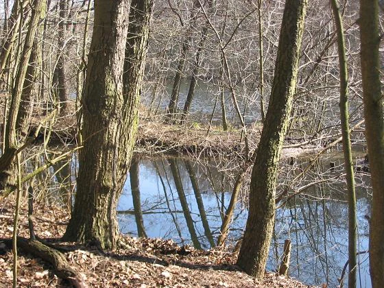
A view through bare trees looking over a small, calm pond with reflections of tree trunks on the water surface in a deciduous forest during late autumn or winter.
A peaceful view of the wooded swamp landscape within the Riemeisterfenn nature reserve.

Riemeisterfenn history and protected-area timeline

The history of Riemeisterfenn reaches back to the medieval period, when the Margrave sold the village of Crummensee to Kloster Lehnin in 1251. Around the year 1301, the abbey merged the village with Zehlendorf and appointed a Riedmeister to oversee the forests and lakes of the area; over time Riedmeister was shortened to Riemeister, and the lake, and later the fen, took its name from this official.

The modern history of the site is inseparable from the dramatic hydrological changes brought by Berlin's industrial-era growth. Between 1861 and 1910, the population of Berlin quadrupled from about 500,000 to over two million. The subsequent demand for drinking water led to intense groundwater extraction throughout the city. By 1911 the original Riemeister See had effectively fallen dry, and in 1913 the Berliner Wasserwerke began pumping Havel water into the lake chain to keep the wetlands viable. This artificial water supply remains in use.

In 1957 a waterworks (Wasserwerk Riemeisterfenn) was built at the southwestern edge of what would later become the nature reserve. Its technical installations were set underground, and the surface buildings were constructed with a deep, prominent reed roof so that the structure would blend into the wetland landscape. Despite contributing only a small fraction of Berlin's total water supply, the plant shaped the modern visibility of the site. It was placed on standby in the 1990s, hosted a restaurant between 2007 and 2012, and then stood empty. On the evening of 7 November 2018, a fire of unknown origin destroyed the entire reed roof of the main building.

Parallel to this hydrological story, ecological protection evolved slowly. Concern for the peatland's flora and fauna was formalized on 4 May 1987, when the Berlin Senate issued a protection ordinance explicitly aimed at preserving the remaining mesotrophic moor pond and alder swamp forest habitat. In 1998, a connection between the fen and the larger chain of lakes, which had formed after a dam break in the 1960s, was sealed by Senate order to shield the nutrient-poor bog vegetation from nutrient-rich lake water. This restoration choice led to the suffocation of a fish population that had developed in the renewed open water, and since then the small lake within the reserve has continued to expand again.

Riemeisterfenn landscape and geographic character

The landscape of Riemeisterfenn is shaped by a low, flat, swampy lowland. Where once the open Riemeister See spread, today a partly silted-in basin remains, with marshy, boggy margins and shallow open water threaded by reed growth. The terrain is flat to gently undulating; the site has no cliffs, peaks or large dunes. Instead, its character is defined by the contrast between dark peat soils, marsh vegetation, floating peat mats and the canalised water that loops through the reserve.

Despite being small, the reserve has clear microtopography. Moist depressions alternate with slightly higher hummocks supporting alder carr and shrubby transitions. The Fennkanal, a narrow artificial canal, conducts water along the northern edge of the site past the protected zone and onward into the Langes Luch reserve and the Grunewaldsee, ensuring that the wetland does not stagnate but also does not flood. The fen feels like a fragment of an older landscape pressed against the dense, modern urban fabric of southwestern Berlin.
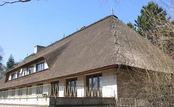
A building with a large thatched roof and a stone terrace, surrounded by bare trees in early spring.
The water works facility located within the Riemeisterfenn nature reserve.

Riemeisterfenn ecosystems, habitats, and plant life

Ecologically, Riemeisterfenn represents one of Berlin's rare surviving mesotrophic peatland systems. Its habitats include open water, transitional mires, reed beds, and alder swamp forest (Erlenbruchwald). The peat substrate and acidic, nutrient-poor groundwater define the ecological character of the site, and create the conditions for plant communities that cannot survive in the surrounding, more nutrient-enriched urban environment.

Management efforts focus on keeping the bog's stratification intact, allowing natural terrestrialisation (Verlandung) to proceed without disturbance, and actively removing invasive species such as Prunus serotina (späte Traubenkirsche) and Acer negundo (eschen-Ahorn). The fluctuating wet-dry zones around the alder carr are deliberately maintained to encourage the dynamic successional processes typical of lowland bog margins.

Riemeisterfenn wildlife and species highlights

The reserve is recognised as habitat for a small but ecologically meaningful community of wetland species. Native fish such as pike (Esox lucius), eel and carp were historically present in the open water sections; they disappeared locally when the dam was closed in 1998 to restore bog conditions. Aquatic and marsh plants, including the rare flowering rush Butomus umbellatus (Schwanenblume) and the threatened Anacamptis palustris (Sumpfknabenkraut), are strongly tied to the site's acidic, low-nutrient water and form a core part of its biodiversity value. The wetland's combination of open water, reed beds and alder carr makes it a stopover and breeding area for typical Berlin wetland birds, though the surrounding forest also supports forest-dwelling fauna common to the wider Grunewald.

Riemeisterfenn conservation status and protection priorities

Riemeisterfenn has conservation significance because it preserves one of the very last lowland mesotrophic peatland fragments in Berlin. Its 1987 protection ordinance specifically targets the conservation of moor pond flora and fauna and of alder swamp forest, and provides for the restoration of habitat suitable for these species. Active conservation work includes the suppression of invasive woody species, the maintenance of the natural terrestrialisation process, and the protection of the peat body's stratification.

Equally important is the site's role in demonstrating how a wetland can be sustained within a heavily modified urban hydrological system, since the broader Grunewald depends on pumped Havel water to compensate for centuries of groundwater extraction. Riemeisterfenn thus also serves as a reference point in discussions about Berlin's groundwater management, forestry and ecological balance, even though it is only about 7.2 hectares in size.

Riemeisterfenn cultural meaning and human context

Culturally, Riemeisterfenn is embedded in the rural and recreational heritage of the Zehlendorf area. The fen, the adjacent Riemeisterstraße and the Riemeister-Grundschule all preserve the memory of a medieval Riedmeister appointed to oversee the local forest and water bodies. The area also has a strong late-19th and early-20th-century excursion culture: the famous local inn Onkel Toms Hütte, just across Onkel-Tom-Straße, was a famous Berlin weekend destination, and the nearby U-Bahn station Onkel Toms Hütte carries on that legacy.

Top sights and standout views in Riemeisterfenn

Riemeisterfenn's main highlights include the surviving peat bog itself, one of Berlin's rarest surviving wetland habitats; the Fennkanal, which connects the protected fen with the broader Grunewaldseenkette; the unusual underground waterworks with its landmark reed roof; and the visible tension between a protected bog ecosystem and a heavily urbanised, water-engineered region.

Best time to visit Riemeisterfenn

Late spring through early autumn is the most rewarding period to experience Riemeisterfenn. In late spring and early summer the bog vegetation, including rare species such as the flowering rush, reaches its peak, and the wetland wildlife is most visible. Mild, damp weather emphasises the marshy character of the site; in winter, frozen bog and reed surfaces highlight the open, quiet structure of the fen but limit access and visibility.

Monthly climate preview

Trace representative temperature and precipitation averages across the year

Riemeisterfenn Climate Normals and Long Term Weather by Month

Representative coordinates record annual temperature extremes spanning sub zero winter minimums to warm summer maximums alongside measured daily precipitation rates. Opening the complete monthly dataset provides comprehensive twelve month climatology distributions for further geographical analysis.
Annual mean9 °C
-1 °C20 °C
Jan-1°
Feb
Mar
Apr
May14°
Jun18°
Jul20°
Aug20°
Sep15°
Oct
Nov
Dec
Warmest month
July

20.3 °C

Coolest month
January

-0.7 °C

Wettest month
July

2.4 mm/day

Driest month
April

1 mm/day

Park location guide

Geography guide, regional context, and park location map for Riemeisterfenn

Riemeisterfenn park geography, regions, and map view in Germany

Understand where Riemeisterfenn sits in Germany through a broader geographic reading of the surrounding landscape, nearby location context, and its mapped position within the national park landscape.

How Riemeisterfenn fits into Germany

Germany is a federal republic in Western and Central Europe with a population of over 83 million across sixteen constituent states. It is Europe's largest economy by nominal GDP and a major global exporter and importer. The capital is Berlin, and the country borders Denmark, Poland, Czech Republic, Austria, Switzerland, France, Luxembourg, Belgium, and the Netherlands.

Wider geography shaping Riemeisterfenn in Germany

Germany is located in Western and Central Europe, spanning 357,022 km². It borders Denmark to the north, Poland and the Czech Republic to the east, Austria and Switzerland to the south, and France, Luxembourg, Belgium, and the Netherlands to the west. The country has coastlines on the Baltic Sea and North Sea to the north, with the Alps located in the southern region.

Map view of Riemeisterfenn

Use this park location map to pinpoint Riemeisterfenn in Germany, understand its exact geographic position, and read its mapped placement within the surrounding landscape more clearly.

Pigeon | © OpenStreetMap contributors

Location context for Riemeisterfenn

BerlinSteglitz-Zehlendorf

Explore the terrain, wetland habitats, and protected environmental character of the Grunewald fen.

Riemeisterfenn Photos and Landscape Scenery: Visualizing Berlin's Rare Peat Bog

Visual documentation reveals the distinct lowland peat soils, reed beds, and alder carr defining the Riemeisterfenn reserve. Detailed photography of the protected wetland ecosystem illustrates its unique microtopography and glacial lake heritage within the urban fringe.

A view through bare trees looking over a small, calm pond with reflections of tree trunks on the water surface in a deciduous forest during late autumn or winter.

A close up view of a thick, mossy tree trunk stretching diagonally across the foreground, overlooking a swampy forest floor with bare trees and dark, muddy ground.

A building with a large thatched roof and a stone terrace, surrounded by bare trees in early spring.

Park atlas

Discover adjacent wetland fragments and connected glacial lake landscapes across southwestern Berlin

Parks Near Riemeisterfenn, Exploring Regional Protected Areas and Wetland Reserves

Browsing parks near Riemeisterfenn reveals surviving peatland fragments and connected hydrological reserves across the regional landscape. Comparing these protected areas provides deeper insight into urban wetland ecosystems and glacial lake chains.
A horizontal watercolor painting showing a wetland landscape with calm water, marshy vegetation, and a background of soft rolling hills and mixed forest trees.
Nature reserveBerlin
About 0.8 km away#1 closest

Northeast

Langes Luch / Dachsheide: Nature Reserve and Glacial Wetland Geography in Berlin

Protected mosaic of bog, forest, and inland dune habitats

Langes Luch / Dachsheide encompasses a rare urban protected area in Berlin, defined by the interplay between low-lying swampy depressions and elevated sandy heath. The site features complex glacial meltwater channels, open transitional mires, and historical terrain modifications, forming an essential study area for local conservation and regional landscape ecology.

Area
0.324 km²
Established
1960
IUCN
IV
Relief
Lowland
A watercolor painting showing a soft green marshy landscape with low hills in the background and a winding stream in the foreground.
Nature reserveBerlin
About 2.8 km away#2 closest

Northeast

Hundekehlefenn Nature Reserve: Geography and Protected Wetland Landscapes in Berlin

Glacial meltwater channel and moorland in Grunewald

Hundekehlefenn represents one of the last surviving pieces of original Berlin vegetation, preserved as a nature reserve within the city limits. This compact protected area showcases a glacial meltwater channel geography, featuring marshy depressions, mesotrophic bog remnants, and alder swamp forests. It serves as an essential ecological link within the Grunewaldseenkette lake chain, providing a window into the natural terrain history of the region.

Area
0.1 km²
Established
1987
Relief
Lowland
Climate
Temperate
Watercolor illustration of a serene wetland scene with soft green hills and a light pink sky.
Nature reserveBerlin
About 3.7 km away#3 closest

North

Sandgrube im Jagen 86 Nature Reserve: Mapped Geography and Protected Area Context

A unique habitat mosaic within the Berlin forest region

Sandgrube im Jagen 86 functions as a protected nature reserve in Berlin, characterized by a bowl-shaped terrain of glacial sands. The area provides a critical habitat for specialized wildlife by balancing nutrient-poor grasslands with open water bodies and sun-exposed slopes, illustrating an effective example of managed conservation within an urban forest.

Area
0.135 km²
Established
1992
IUCN
IV
Relief
Lowland
Nature reserveBerlin
About 5.6 km away#4 closest

Northwest

Windmühlenberg Nature Reserve: Glacial Terrain and Steppe Flora in Berlin

Protected sand-dry grasslands on the Nauen Plateau edge

Windmühlenberg preserves a rare ecological landscape in western Berlin. This glacial hill and nature reserve functions as a protected habitat for steppe-relict flora and specialized insects, serving as a critical point of interest for understanding the geomorphology and sand-based grassland environments of the Havel river valley.

Area
0.051 km²
Established
2002
Relief
Upland
Climate
Temperate
Nature reserveBerlin
About 7 km away#5 closest

North

Fließwiese Ruhleben: A Glacial Nature Reserve and Wetland Mosaic in Berlin

Mapping a unique urban protected area and its peat marsh topography

Fließwiese Ruhleben is a protected nature reserve in western Berlin that preserves a distinct relic of Weichselian glaciation. The site features a narrow, basin-like depression carved by glacial meltwater, supporting a rich diversity of peat-forming marshland and alder swamp forests. This protected area remains a vital node for regional biodiversity, contrasting sharply with the surrounding urban landscape of the Teltow plateau.

Area
0.118 km²
Established
1959
Relief
Lowland
Climate
Temperate
Protected landscapeBerlin
About 7.2 km away#6 closest

North

Tiefwerder-Wiesen Protected Landscape: Berlin Riverine Geography and Floodplain Map

Mapping the historic Havel river floodplains and wetland habitats.

Tiefwerder-Wiesen serves as an important ecological corridor in Berlin, safeguarding the last functional pike spawning grounds within the city. This protected landscape contains a dense network of river arms, ditches, and sedge meadows that illustrate the historical and ongoing geomorphological processes of the Havel river valley.

Area
0.667 km²
Established
1960
Relief
Lowland
Climate
Temperate
Watercolor painting of a green wetland area with soft, blurred rolling hills in the background.
Nature reserveBerlin
About 8.4 km away#7 closest

Southwest

Großes Fenn Nature Reserve: Protected Peatland and Kettle Bog Geography in Berlin

A study of post-glacial landforms and mire environments.

Großes Fenn represents a rare urban kettle bog formed during the last glacial period, now protected within the Berlin region. This reserve showcases the historical peat-forming processes and the fragile ecological balance of small depressions in the Düppeler Forest, offering a compact site for understanding glacial landscape legacies.

Area
0.064 km²
Established
1986
IUCN
IV
A horizontal watercolor illustration depicting a calm lake surrounded by soft green forest and distant hazy hills.
Protected areaBerlin
About 9 km away#8 closest

Southwest

EU-Vogelschutzgebiet Westlicher Düppeler Forst: Protected Area and Regional Geography

Ecological sanctuary and Havel lakeshore landscape in Berlin

Located in the Steglitz-Zehlendorf district, this protected area spans nearly 10 square kilometres of diverse woodland and aquatic terrain. The site combines historical cultural landmarks with essential breeding grounds for migratory birds, including significant woodpecker populations and varied riparian corridors throughout the southwestern Berlin borderlands.

Area
9.44 km²
Established
2003

Common questions about visiting, size, designation, and location context for Riemeisterfenn

Riemeisterfenn FAQs for park facts, access, geography, and protected area context

Find quick answers about Riemeisterfenn, including protected-area facts, park geography, trail and visitor context, and how the park fits into its surrounding country and regional landscape.
MoriAtlas Explorer

Continue Your Protected Areas Search Across the Global Atlas

Deepen your exploration by continuing the structured search for national parks and protected areas worldwide. Utilize the comprehensive filtering capabilities to compare different conservation landscapes and refine your understanding of global park geography. Discover more about the distribution and characteristics of protected natural areas.

Global natural geography