
Mori Atlas logo
Nature reserveRietberger Emsniederung mit Steinhorster Becken

Tracing the floodplain and wetland habitats of this vital North Rhine-Westphalia nature reserve

Rietberger Emsniederung mit Steinhorster Becken: Mapped Protected Landscapes and Riverine Geography

(EU-Vogelschutzgebiet „Rietberger Emsniederung mit Steinhorster Becken")

The Rietberger Emsniederung mit Steinhorster Becken encompasses a groundwater-influenced lowland corridor defined by the meandering Ems river. This protected area features a mosaic of wet meadows, reed beds, and marshes that form a critical habitat network within the Münsterland region. Gain deeper insight into the terrain through maps detailing the floodplain boundaries and the interplay between aquatic and meadow environments in this German nature reserve.

Natura 2000EU Bird Protection Areafloodplainriverine lowlandwet meadowsreedbeds
A colorful vector-style illustration of a valley featuring a cascading waterfall on a rocky cliff, a winding river in the foreground, and pine trees under a light sky with clouds.

Rietberger Emsniederung mit Steinhorster Becken

Nature reserve

Park overview

Structured park overview, official facts, and landscape profile for Rietberger Emsniederung mit Steinhorster Becken

Rietberger Emsniederung mit Steinhorster Becken park facts, protected area profile, and essential visitor context

Review the core facts for Rietberger Emsniederung mit Steinhorster Becken, including designation, size, terrain, visitor scale, habitats, and operating context in one park-focused overview.

About Rietberger Emsniederung mit Steinhorster Becken

Rietberger Emsniederung mit Steinhorster Becken represents a textbook example of an intensively farmed European lowland landscape that retains enough seminatural floodplain character to support a remarkable bird fauna. Despite being embedded in an agricultural region, the area's combination of high groundwater levels, historic river dynamics, and extensive grassland use creates habitat conditions that are increasingly rare in densely settled parts of central Europe.

The site stretches along the upper Ems between roughly Verl-Kaunitz and Rietberg, taking in the so-called Steinhorster Becken, an abandoned or partially deactivated basin that contributes standing water and shallow flood zones to the floodplain system. Around the river, meadows, fens, sedge stands, and small reedbeds frame quiet backwaters, drainage ditches, and seasonally flooded depressions. Small patches of deciduous woodland and plantation forest add vertical structure without dominating the open character of the area.

Ecologically, the area's importance lies as much in its openness as in its water. Waders such as lapwing, snipe, black-tailed godwit, and little ringed plover depend on moist meadows and shallow inundations. Wildfowl, including garganey, Eurasian teal, common pochard, and shoveler, depend on shallow eutrophic waters and lush reed margins. Raptors such as marsh harrier, red kite, hen harrier, and wintering great grey shrike use the combination of open ground and perch-rich edges. Migratory flocks of geese, cranes, and swans use the safe, disturbance-light floodplain as a stopover and wintering refuge, while species such as bittern, water rail, and reed-reed warbler highlight the value of dense vegetated water margins.

Beyond birdlife, the area contributes to the broader conservation of Ems floodplain habitats, groundwater-dependent meadows, and small-scale cultural landscapes shaped by traditional grassland management. It is a working example of how EU Birds Directive protection can align with continued agricultural use, provided that water regimes, mowing practices, and disturbance levels are carefully managed.

Quick facts and research context for Rietberger Emsniederung mit Steinhorster Becken

The protected area lies on the upper Ems near Rietberg, in the eastern Münsterland region of North Rhine-Westphalia, spanning the Gütersloh and Paderborn districts. It carries the official site code DE-4116-401 and was designated as a European Bird Protection Area (EU-Vogelschutzgebiet) in 2000.

Its administration falls under the Regierungspräsidium Detmold, and it is part of the EU Natura 2000 network under the Birds Directive. The site covers roughly nine square kilometres of floodplain habitat dominated by moist and mesophilic grassland, drained former meadows, inland waters, marshes, reed belts, and a small share of woodland and farmland. Its significance rests primarily on its role for wetland and farmland birds of the open Ems floodplain.

Protection and recognition

Documented protection scope and management records for this terrestrial protected area

Protection Status and International Recognition for Rietberger Emsniederung mit Steinhorster Becken

Terrestrial protection records for Rietberger Emsniederung mit Steinhorster Becken outline documented conservation status and official management parameters. Verified database entries compile designated boundary frameworks and international recognition details without additional assumptions.

Protection details

Protection scope
Terrestrial
Transboundary protection
No
WDPA ID
555537478
Park context

Deeper park guide and search-rich context for Rietberger Emsniederung mit Steinhorster Becken

Rietberger Emsniederung mit Steinhorster Becken history, landscape, wildlife, and travel context

Explore Rietberger Emsniederung mit Steinhorster Becken through its history, landscape character, ecosystems, wildlife, conservation priorities, cultural context, and seasonal travel timing in a structured park guide built for atlas discovery and search intent.

Why Rietberger Emsniederung mit Steinhorster Becken stands out

The site is best known as one of the most important bird areas in North Rhine-Westphalia, combining roles as a breeding ground, a migration stopover, and a wintering refuge within a single compact floodplain. Its particular reputation rests on the energy-rich mosaic of wet grassland, shallow floodwaters, reedbeds, and abandoned cultural landscapes that support waders, wildfowl, owls, harriers, and songbirds of conservation concern. Many of the bird species for which the area is designated are emblematic of Europe's open wetland landscapes: snipe, lapwing, black-tailed godwit, common crane, white stork, black stork, bluethroat-associated species, bittern, marsh harrier, kingfisher, and hobby, along with winter visitors such as bean goose, greater white-fronted goose, whooper swan, hen harrier, and great grey shrike.
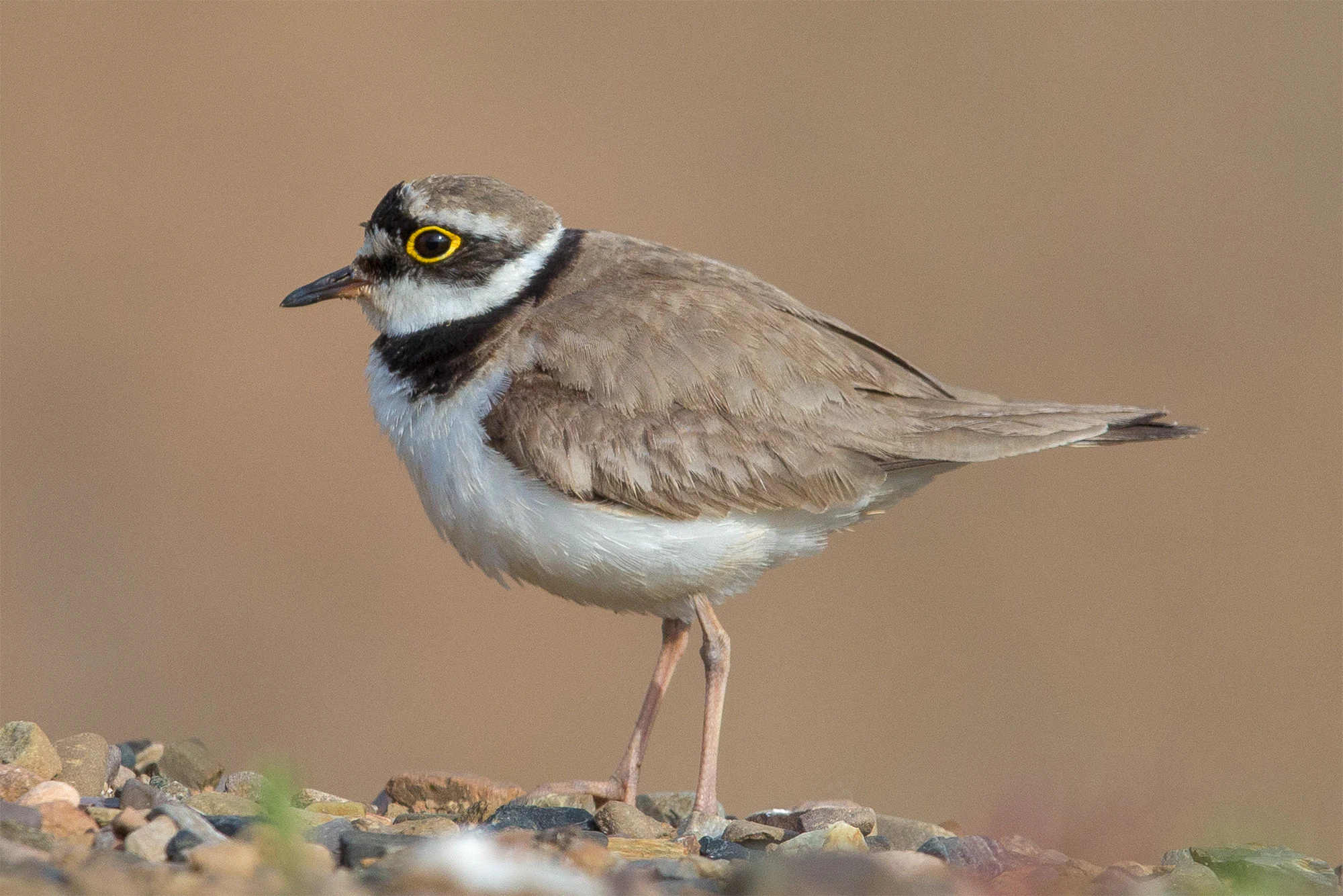
Side profile of a little ringed plover standing on gravel, showing its brown wings, white underbelly, dark neck band, and yellow eye ring.
A little ringed plover, a bird species commonly found in the wetland habitats of the Rietberger Emsniederung nature reserve.

Rietberger Emsniederung mit Steinhorster Becken history and protected-area timeline

The site's modern identity dates to 2000, when it was designated as an EU Bird Protection Area (EU-Vogelschutzgebiet) under the European Union Birds Directive by the Regierungspräsidium Detmold. Its designation reflects a wider European effort to identify and protect the most important bird sites of the continent as part of the Natura 2000 network.

The floodplain itself is much older as a landscape element. The upper Ems near Rietberg has long been shaped by a combination of natural river dynamics and centuries of grassland management. Traditional low-intensity use of wet meadows, combined with the area's groundwater-rich soils, created the open, water-influenced land cover that today underpins its conservation value. The Steinhorster Becken adds a distinct basin landscape to the system, likely tied to past extraction, drainage changes, or river meander history, which today contributes standing water and shallow flood zones.

In the late twentieth century, growing awareness of widespread declines in European farmland and wetland birds gave the site particular importance. Its formal recognition as a Special Protection Area brought EU-level protection aims to the existing agricultural landscape, with conservation targets set for an extensive list of breeding, migratory, and wintering species.

Rietberger Emsniederung mit Steinhorster Becken landscape and geographic character

The defining physical setting is the floodplain of the upper Ems, a broad, flat, groundwater-influenced lowland corridor that winds through the eastern Münsterland. Elevations are low and the terrain is gently undulating at most, with the Ems meandering slowly between Rietberg and the Kaunitz area of Verl. The valley floor carries the visual identity of the site: open, green, and quiet, with waterways, ditches, reed edges, and damp meadows rather than dramatic relief.

Around the river channel itself, shallow oxbows, backwaters, and slow-moving stretches create soft-water habitats with emergent vegetation. The Steinhorster Becken adds a more basin-like character, with deeper or more persistent standing water and a distinctive ring of reeds and wet meadows. Above the immediate river zone, the floodplain gives way to a checkerboard of meadows, fens, and small fields, broken only by occasional hedge lines, scattered trees, and very limited woodland patches.

The visual impression is essentially that of a traditional north German lowland river-corridor landscape: horizontal vistas, soft green and brown tones, ribbon-like reed lines along ditches, and a subtle interplay between water surface, meadow, and sky rather than dramatic geological features. This understated physical character is precisely what enables the area's bird importance to shine.
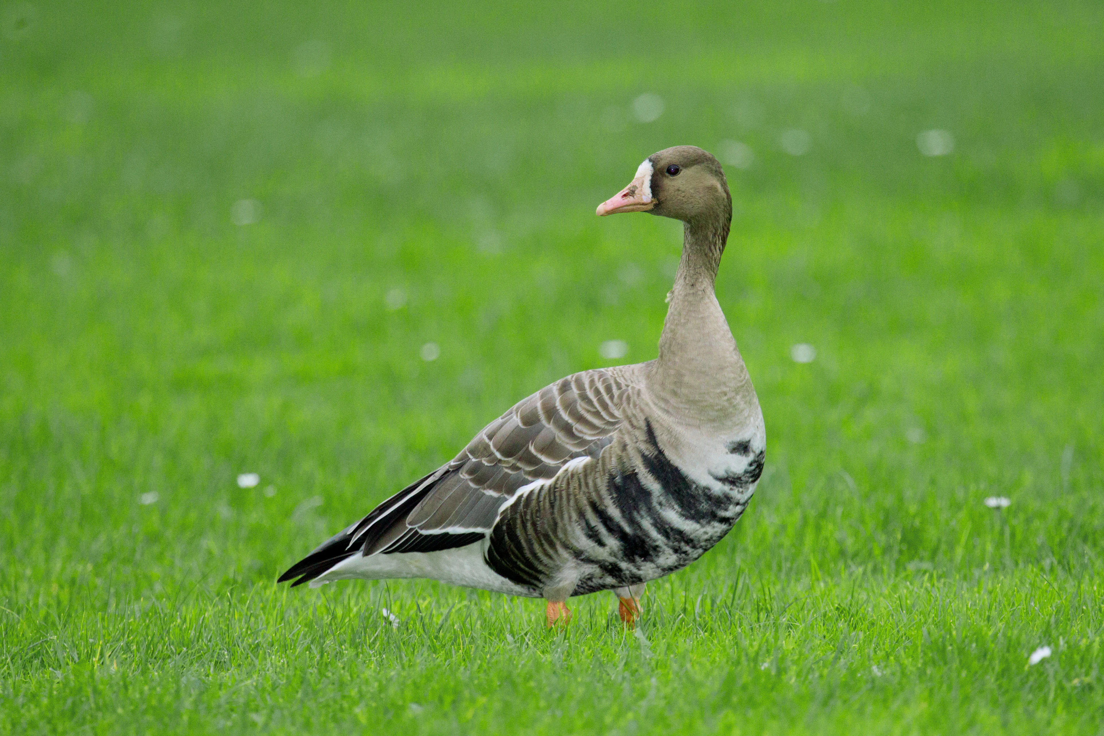
A side profile view of a Greater White-fronted Goose with brown and white plumage standing on bright green grass.
A Greater White-fronted Goose standing in the grasslands of the Rietberger Emsniederung nature reserve.

Rietberger Emsniederung mit Steinhorster Becken ecosystems, habitats, and plant life

Habitat diversity, not dramatic relief, is the area's ecological mainstay. The Natura 2000 habitat classification shows a clear dominance of open, water-influenced land cover: a large share of moist and mesophilic greenland, a significant area of drained but still meadow-like former wet grassland, smaller but ecologically important shares of inland standing and flowing waters, marshes and reedbeds, with the remainder split among small woodland patches, plantation forest, farmland, and minor built infrastructure.

Ecologically, the mosaic interlinks three core habitat systems. The first is the active river-floodplain system of the Ems, with its natural or near-natural banks, soft sediments, and dynamic flooding. The second is the fen and meadow complex, where high groundwater, traditional grassland use, and seasonally inundated depressions sustain waders, snipe-like species, and waterfowl. The third is the standing-water and reed complex of the Steinhorster Becken and similar basins, providing the dense vertical structure that species such as bittern, water rail, marsh harrier, and reed warblers require.

Edges and transitions are unusually important here. Reed-to-water margins, grassy ditches within meadows, scattered bushes, and isolated trees all act as small-scale habitat features that allow the area to support a bird community more diverse than its modest size would suggest.
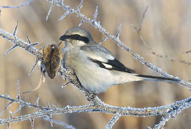
A Great Grey Shrike, a gray bird with a black eye stripe, sits on a frost-covered thorny branch with a small mammal prey item impaled on a thorn.
A Great Grey Shrike perched on a frost-covered branch, holding prey.

Rietberger Emsniederung mit Steinhorster Becken wildlife and species highlights

The site's wildlife profile is overwhelmingly defined by birds, supported by a floodplain landscape that combines open wet grassland, reed belts, shallow waters, and nearby arable land. Breeding birds of conservation concern include lapwing, snipe, black-tailed godwit, common ringed plover, little ringed plover, garganey, Eurasian teal, shoveler, common pochard, marsh harrier, hobby, kingfisher, nightingale, golden oriole, great reed warbler, reed warbler, bittern, water rail, corncrake, whinchat, and wryneck-associated species groups. Raptors such as red kite and honey buzzard use the area's tall old trees and field edges.

During migration and winter, the bird community changes character. Large flocks of greater white-fronted goose, bean goose, whooper swan, and common crane use the open floodplain as a staging and wintering refuge. Waders, including dunlin, ruff, greenshank, spotted redshank, curlew sandpiper, wood sandpiper, and jack snipe, use the area's shallow waters and wet meadows. White stork and black stork forage the damp grasslands, while great egret, hen harrier, and great grey shrike patrol the open ground in winter.

The bittern and corncrake in particular signal the area's quiet, undisturbed wet-reed character, while the kingfisher reflects the continued ecological quality of the Ems itself. The richness of breeding, migratory, and wintering roles within a single compact site is what makes the area exceptional for an inland German locality.
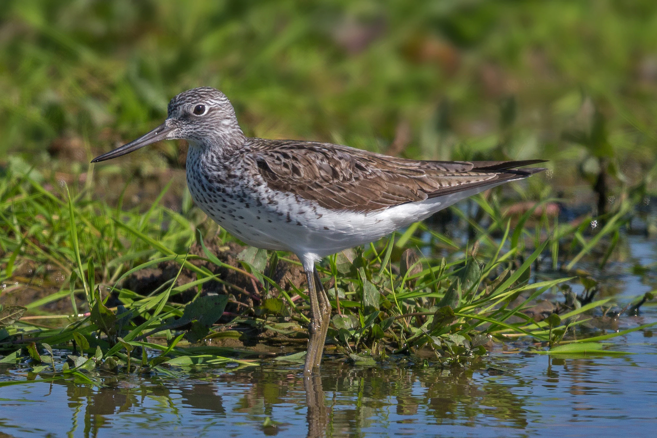
A Common Greenshank standing in shallow water surrounded by green shoreline grasses.
A Common Greenshank foraging in the shallow wetlands of the Rietberger Emsniederung.

Rietberger Emsniederung mit Steinhorster Becken conservation status and protection priorities

The site is embedded in the European Union's Nature and Birds Directives, with explicit conservation objectives tied to its designation as an EU Bird Protection Area and its inclusion in the Natura 2000 network. Its formal purpose is to secure sufficient habitat quality and quantity for a defined set of breeding, migratory, and wintering bird species, ranging from small waders to large raptors, storks, and waterfowl.

Its conservation significance extends beyond birds. The floodplain's mosaic of wet meadows, fens, reedbeds, oxbow waters, and small deciduous woodlands is widely recognised as a priority landscape for lowland river ecology in the region. Maintaining high groundwater levels, retention of traditional grassland management, prevention of further drainage intensification, and reduction of disturbance during sensitive breeding and wintering periods are all central to the area's long-term viability.

Threats and pressures include agricultural intensification, drainage of remaining wet meadows, loss of shallow-water and reed-edge habitats, disturbance from infrastructure including unguarded power lines and wind turbines, and loss of important landscape features such as hedgerows, scattered trees, and small ponds. The site's conservation strategy emphasises continued agricultural use but in a form compatible with the needs of its most sensitive species, including delayed mowing, retention of wet depressions, and protection of nesting, roosting, and feeding areas from disturbance.

Rietberger Emsniederung mit Steinhorster Becken cultural meaning and human context

Rietberger Emsniederung mit Steinhorster Becken sits within a long-settled lowland cultural landscape in the eastern Münsterland and western Ostwestfalen regions, where the upper Ems has shaped human land use for centuries. The floodplain's characteristic mix of damp meadows, ditches, hedges, and scattered farmsteads reflects a centuries-old relationship between farming communities and a groundwater-rich river valley.

Traditional grassland management, modest stocking densities, late-season mowing, and careful use of wet meadows are all part of the area's cultural heritage, and they continue to underpin its conservation value today. The broader region has a strong agricultural identity, and the protected area functions less as a wilderness set apart from human activity and more as a cultural landscape where bird conservation depends on the continuation of informed, low-intensity land management in cooperation with local farmers and landowners.
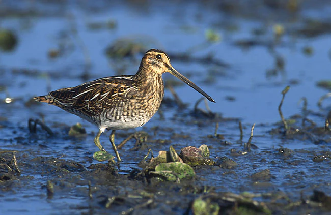
A common snipe, a mottled brown wader bird with a long straight beak, stands in shallow, muddy water.
A common snipe standing in a wetland habitat at the Rietberger Emsniederung.

Top sights and standout views in Rietberger Emsniederung mit Steinhorster Becken

The site's strongest single feature is the overlap of breeding, migration, and wintering bird functions within one small floodplain, unusual even within the European Natura 2000 network. It is also notable for the way it retains habitat diversity, with floodplain meadows, reedbeds, fens, and standing waters all coexisting in close proximity, despite the surrounding pressure of agricultural intensification.

Among species highlights are the presence of corncrake and bittern as indicators of undisturbed wet-reed habitat, the breeding populations of lapwing, snipe, and black-tailed godwit, the winter gatherings of white-fronted and bean goose flocks, and the regular occurrence of white stork, black stork, red kite, and large flocks of common crane during migration. The combined presence of kingfisher along the Ems and hobby overhead reinforces the area's mixed open-water and open-land character.
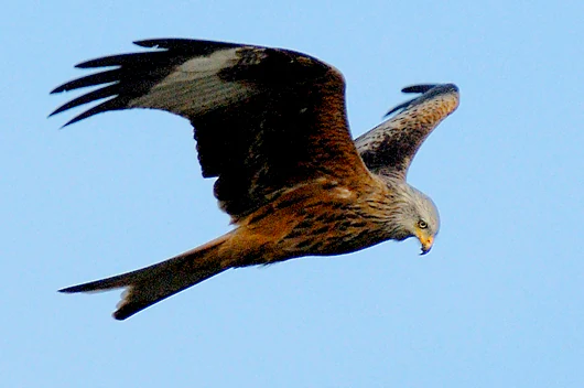
A red kite bird seen from below, soaring with wings spread wide against a clear blue sky.
A red kite in flight over the Rietberger Emsniederung.

Best time to visit Rietberger Emsniederung mit Steinhorster Becken

The area's seasonally changing bird life gives it a different feel at different times of year. Spring is the season when breeding waders, harriers, and songbirds are most active, with snipe, lapwing, and black-tailed godwit displaying on wet meadows from February into early summer. The period from March through June offers the richest mix of breeding bird activity across meadows, reedbeds, and ditches.

Late summer and autumn bring migration into focus, with waders, storks, and large flocks of geese and cranes using the floodplain as a stopover. Winter can also be rewarding, with concentrations of white-fronted and bean geese, whooper swans, and raptors including hen harrier and great grey shrike patrolling the open meadows. Quiet observation from public paths and roads is most productive in early morning or late afternoon, when bird activity peaks and disturbance is at its lowest.

Monthly climate preview

Long term temperature and monthly precipitation averages for recorded protected terrain

Rietberger Emsniederung mit Steinhorster Becken Climate Normals and Weather by Month

Historical monitoring at a representative coordinate tracks the measured annual temperature cycle and monthly precipitation totals for Rietberger Emsniederung mit Steinhorster Becken. Detailed twelve month climate profiles provide comprehensive long term normals for ongoing geographical research.
Annual mean9 °C
1 °C18 °C
Jan
Feb
Mar
Apr
May13°
Jun16°
Jul18°
Aug18°
Sep14°
Oct
Nov
Dec
Warmest month
July

18.1 °C

Coolest month
January

0.5 °C

Wettest month
December

2.6 mm/day

Driest month
April

1.6 mm/day

Park location guide

Geography guide, regional context, and park location map for Rietberger Emsniederung mit Steinhorster Becken

Rietberger Emsniederung mit Steinhorster Becken park geography, regions, and map view in Germany

Understand where Rietberger Emsniederung mit Steinhorster Becken sits in Germany through a broader geographic reading of the surrounding landscape, nearby location context, and its mapped position within the national park landscape.

How Rietberger Emsniederung mit Steinhorster Becken fits into Germany

Germany is a federal republic in Western and Central Europe with a population of over 83 million across sixteen constituent states. It is Europe's largest economy by nominal GDP and a major global exporter and importer. The capital is Berlin, and the country borders Denmark, Poland, Czech Republic, Austria, Switzerland, France, Luxembourg, Belgium, and the Netherlands.

Wider geography shaping Rietberger Emsniederung mit Steinhorster Becken in Germany

Germany is located in Western and Central Europe, spanning 357,022 km². It borders Denmark to the north, Poland and the Czech Republic to the east, Austria and Switzerland to the south, and France, Luxembourg, Belgium, and the Netherlands to the west. The country has coastlines on the Baltic Sea and North Sea to the north, with the Alps located in the southern region.

Map view of Rietberger Emsniederung mit Steinhorster Becken

Use this park location map to pinpoint Rietberger Emsniederung mit Steinhorster Becken in Germany, understand its exact geographic position, and read its mapped placement within the surrounding landscape more clearly.

Pigeon | © OpenStreetMap contributors

Location context for Rietberger Emsniederung mit Steinhorster Becken

Nordrhein-Westfalen

Visualizing the wet meadows, river corridors, and wetland habitats of North Rhine-Westphalia

Rietberger Emsniederung mit Steinhorster Becken Photos, Scenery, and Protected Landscape Views

Visual records capture the flat lowland terrain, meandering river channels, and extensive reed beds defining Rietberger Emsniederung mit Steinhorster Becken. Photographic documentation reveals the subtle floodplain character and complex mosaic of protected habitats supporting regional bird species.

Side profile of a little ringed plover standing on gravel, showing its brown wings, white underbelly, dark neck band, and yellow eye ring.

A white great egret with a yellow beak standing and looking down into green grass in a field.

A side profile view of a Greater White-fronted Goose with brown and white plumage standing on bright green grass.

A Great Grey Shrike, a gray bird with a black eye stripe, sits on a frost-covered thorny branch with a small mammal prey item impaled on a thorn.

A Common Greenshank standing in shallow water surrounded by green shoreline grasses.

A male Eurasian teal duck with distinctive green eye patch swimming in calm water.

A common snipe, a mottled brown wader bird with a long straight beak, stands in shallow, muddy water.

A red kite bird seen from below, soaring with wings spread wide against a clear blue sky.

A peaceful landscape with a small pond surrounded by green meadows and scattered trees under a partly cloudy sky.

A small little grebe bird with reddish brown neck and dark feathers swimming in shallow water near a mossy rock.

Park atlas

Compare adjacent riverine floodplains, wet meadows, and bird sanctuaries across the surrounding region.

Explore Parks Near Rietberger Emsniederung mit Steinhorster Becken and Regional Protected Areas

Browse other protected areas and river-corridor habitats situated near Rietberger Emsniederung mit Steinhorster Becken. Comparing adjacent regional landscapes reveals broader patterns in lowland conservation and wetland ecology.
A soft watercolor painting depicting a marshy wetland with green meadows, tall grasses, and distant rolling hills on a white background.
Nature reserveKreis Gütersloh
About 4.6 km away#1 closest

Northwest

Im Binner Nature Reserve: Geographic Overview of the Ems Sand Plain Protected Landscape

Mapped wetlands and meadow habitats in Kreis Gütersloh, Germany

Im Binner is a defined nature reserve that anchors a fragment of the historic Ems sand plain ecosystem. This site encompasses a distinctive mix of wet grasslands, shrub-lined boundaries, and converted aquatic habitats, serving as an essential ecological refuge within the intensively farmed lowland geography of North Rhine-Westphalia.

Area
0.3 km²
Established
1988
IUCN
IV
Protected landscapeKreis Paderborn
About 11 km away#2 closest

East

Landschaftsschutzgebiet Delbrücker Rücken Protected Landscape Map and Regional Context

A rural ridge mosaic in the Kreis Paderborn district

This protected landscape in the Kreis Paderborn district features a characteristic mix of deciduous forests, field hedgerows, and agricultural zones on a gentle Westphalian ridge. Its geographic layout provides a clear example of rural land protection integrated into the local environmental buffer system, showcasing a distinct mosaic of terrain that stretches across the lands north and east of Delbrück.

Area
16.1 km²
Established
1970
Relief
Lowland
Climate
Temperate
A horizontal watercolor painting showing a small winding river flowing through a lush green forest with soft pink and yellow meadow areas in the foreground.
Nature reserveKreis Gütersloh
About 12 km away#3 closest

Northeast

Holter Wald Nature Reserve: Mapping the Protected Woodland and Senne Landscape of Kreis Gütersloh

A major contiguous forest block on the eastern edge of the Westfälische Bucht

Situated in the district of Kreis Gütersloh, Holter Wald is a significant protected area defined by its sandy Senne soils and network of parallel brook valleys. The forest provides a critical lowland habitat for diverse flora and fauna, serving as a rare, large-scale woodland anchor within a largely agricultural region. Explore the terrain characteristics and ecological structure of this key North Rhine Westphalia site.

Area
6.13 km²
Established
2008
IUCN
IV
Relief
Lowland
A watercolor painting showing a soft, peaceful landscape with bare trees in the foreground, green trees in the midground, and distant hills under a pale sky.
Nature reserveNorth Rhine-Westphalia
About 16 km away#4 closest

North

Kampeters Kolk Nature Reserve: Geographic Overview and Protected Wetland Boundaries

Senne region heath pond and wetland mosaic in North Rhine-Westphalia

Kampeters Kolk preserves a significant fragment of the historic Senne heath landscape in North Rhine-Westphalia. The reserve centers on a small, artificial pond created by peat extraction, now surrounded by a rich sequence of sedges, reed stands, and willow-alder shrub thickets that provide critical habitats for local amphibian populations.

Area
0.02 km²
Established
1993
IUCN
IV
A horizontal watercolor painting depicting a soft-toned landscape with scattered evergreen trees and undulating, sandy terrain under a light sky.
Nature reserveNordrhein-Westfalen
About 16 km away#5 closest

East

Moosheide Nature Reserve: Mapping the Ancient Inland Dune Landscapes of Nordrhein-Westfalen

Protected heathland and spring-fed habitat geography.

Moosheide provides a focused look at the geomorphology of the western Senne region. This reserve protects some of the oldest inland dunes in northwestern Germany, alongside a rare juxtaposition of dry sandy grasslands and groundwater-dependent stream valleys that support high species diversity.

Area
4.427 km²
Established
1994
IUCN
IV
Relief
Lowland
A watercolor painting of a wetland landscape with soft green hills, trees, and a winding waterway.
Nature reserveNorth Rhine-Westphalia
About 17 km away#6 closest

Northeast

Kipshagener Teiche Nature Reserve: A Protected Wetland Sanctuary in North Rhine-Westphalia

Geographic analysis of historic bogs and managed wetland habitats

Kipshagener Teiche is a small but essential nature reserve in the Senne region, characterized by a distinct mosaic of ponds, transitional bog, and wet heath. Originally protected in 1937, the site serves as a vital record of wetland biodiversity and recovery in western Germany. Its varied topography, featuring dune-based pine plantations and swamp forest, offers a precise look at the intersection of conservation and landscape management in a human-influenced region.

Area
0.113 km²
Established
1970
IUCN
IV
Nature reserveNordrhein-Westfalen
About 18 km away#7 closest

West

Märzenbecherwald Nature Reserve: Wetland Mosaic and Protected Forest in Nordrhein-Westfalen

A rare calcareous fen and alder swamp forest ecosystem

This protected nature reserve in the Warendorf district serves as a vital ecological anchor, preserving a mosaic of spring-fed seeps, damp woodlands, and calcareous fens. Despite its modest size, the area provides a sharp contrast to the surrounding agricultural fields of the Münsterland region, maintaining a essential water-logged habitat for specialized plant species.

Area
0.016 km²
Established
1995
IUCN
IV
Relief
Lowland
Watercolor painting of a green and pink moor landscape with a distant tree line.
Nature reserveNordrhein-Westfalen
About 19 km away#8 closest

Northwest

Hühnermoor Nature Reserve: Geographic Analysis of a Protected Peatland in Nordrhein-Westfalen

A preserved raised-bog landscape and historic botanical refuge

Hühnermoor represents a rare, compact peatland ecosystem situated between ancient sand dunes in the Münsterland region. This nature reserve functions as a critical protected landscape, offering deep insights into regional vegetation history through its stratified peat layers while supporting threatened specialist wetland species.

Area
0.085 km²
Established
1938
IUCN
IV
Relief
Lowland

Common questions about visiting, size, designation, and location context for Rietberger Emsniederung mit Steinhorster Becken

Rietberger Emsniederung mit Steinhorster Becken FAQs for park facts, access, geography, and protected area context

Find quick answers about Rietberger Emsniederung mit Steinhorster Becken, including protected-area facts, park geography, trail and visitor context, and how the park fits into its surrounding country and regional landscape.
MoriAtlas Explorer

Continue Your Protected Areas Search Across the Global Atlas

Deepen your exploration by continuing the structured search for national parks and protected areas worldwide. Utilize the comprehensive filtering capabilities to compare different conservation landscapes and refine your understanding of global park geography. Discover more about the distribution and characteristics of protected natural areas.

Global natural geography