

Mori Atlas logo
Biosphere reserveRío Plátano Biosphere Reserve

Mapping the watershed, coastal mangroves, and mountainous interior of this critical Caribbean conservation zone.

Río Plátano Biosphere Reserve: A Deep Dive Into Honduran Protected Landscapes and Geography

(Reserva de la Biosfera Río Plátano)

The Río Plátano Biosphere Reserve encompasses a vast protected landscape in the Gracias a Dios Department of Honduras, spanning from the Caribbean coastline into rugged interior mountain terrain. This extensive region serves as a central pillar of the Mesoamerican Biological Corridor, featuring a complex network of lowland rainforests, pine savannas, and the expansive watershed of the Río Plátano. Beyond its ecological diversity, the area supports a rich mosaic of indigenous heritage and critical habitats for endangered wildlife.

tropical rainforestbiosphere reserveUNESCO World Heritage SiteWorld Heritage in DangerMesoamerican Biological CorridorIndigenous territories

Río Plátano Biosphere Reserve

Biosphere reserve

Park overview

Structured park overview, official facts, and landscape profile for Río Plátano Biosphere Reserve

Río Plátano Biosphere Reserve park facts, protected area profile, and essential visitor context

Review the core facts for Río Plátano Biosphere Reserve, including designation, size, terrain, visitor scale, habitats, and operating context in one park-focused overview.

About Río Plátano Biosphere Reserve

The Río Plátano Biosphere Reserve is one of the most significant protected natural areas in Central America, occupying a vast band of land along the Caribbean coast of Honduras. Its name derives from the Río Plátano, a winding river whose watershed and floodplain define much of the reserve's character. From the coastal lagoons and mangrove estuaries in the north, the landscape climbs through flats and foothills into an interior of forested mountains, granite formations, and river valleys. Punta Piedra, the reserve's highest point, rises over 1,300 meters above sea level, while dramatic granite features such as Pico Dama shape the mountainous interior.

The reserve forms a critical link in the Mesoamerican Biological Corridor, a continuous stretch of natural habitat that runs from southern Mexico through Central America. By maintaining extensive forest cover at the landscape scale, Río Plátano helps connect populations of wide-ranging tropical species that cannot survive in small, isolated patches of habitat. Its interior remains one of the few regions in Central America where large predators and other far-ranging mammals still maintain viable populations, and it is widely cited as one of the most important sites for jaguar conservation in the region.

Beyond its ecological role, Río Plátano is also a place of deep human history. The area was first set aside for protection in 1960 as the Ciudad Blanca Archaeological Reserve, named for the legendary lost city rumored to lie in the dense forests southeast of the coast. It was re-designated as a biosphere reserve in 1980 and inscribed as a UNESCO World Heritage Site two years later, making it one of Central America's longest-standing international natural heritage designations. Today, the reserve continues to function simultaneously as a wildlife refuge, an Indigenous homeland, and an archaeological landscape with over 200 recorded sites.

Quick facts and research context for Río Plátano Biosphere Reserve

The Río Plátano Biosphere Reserve lies in the Gracias a Dios department of northeastern Honduras, bordering the Caribbean Sea near the town of Palacios. It covers a vast expanse centered on the watershed of the Río Plátano and includes coastal lagoons, inland mountains, river valleys, and broad marshlands.

Established as a biosphere reserve and UNESCO World Heritage Site in 1982, the reserve is internationally classified as IUCN Category II, recognizing it as a national park-level protected area. It is part of the Mesoamerican Biological Corridor and has been placed on the List of World Heritage in Danger on two occasions. The reserve is governed through Honduras's Department of Protected Areas and Wildlife and supports a resident population of more than 2,000 people drawn from multiple Indigenous and mestizo communities.

Protection and recognition

Documented designation history, mixed protection scope, and official recognition sources

Río Plátano Biosphere Reserve Protection Status and International Recognition

Río Plátano Biosphere Reserve maintains a documented mixed protection status established through historical designation records dating back to 1982. Official records outline international recognition data, including UNESCO World Heritage and Biosphere Reserve listings, for structured atlas analysis.

International recognition

Protection details

Protection scope
Mixed
Designated year
1982
Transboundary protection
No
Core area
2,107.34 km²
Buffer area
3,250 km²
Park context

Deeper park guide and search-rich context for Río Plátano Biosphere Reserve

Río Plátano Biosphere Reserve history, landscape, wildlife, and travel context

Explore Río Plátano Biosphere Reserve through its history, landscape character, ecosystems, wildlife, conservation priorities, cultural context, and seasonal travel timing in a structured park guide built for atlas discovery and search intent.

Why Río Plátano Biosphere Reserve stands out

Río Plátano is celebrated for holding some of the largest surviving tracts of undisturbed tropical rainforest in Central America. Its mixture of coastal mangroves, pine savannas, gallery forests, and montane interior makes it one of the most ecologically varied protected landscapes on the Caribbean slope of the isthmus. The reserve is also widely known as a refuge for endangered and wide-ranging wildlife, including jaguars, Baird's tapirs, giant anteaters, scarlet and military macaws, and harpy eagles. Beyond its biodiversity, it is recognized for sheltering living Indigenous cultures, particularly the Miskito, Pech, and Garifuna communities, alongside more than 200 archaeological sites linked to pre-Columbian history and to the legendary传说 of La Ciudad Blanca.
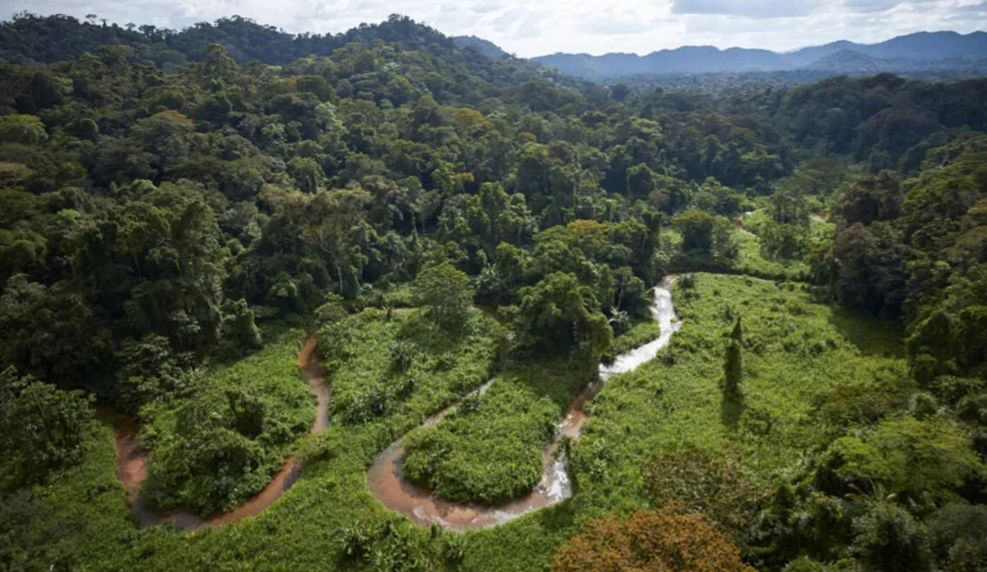
An aerial shot of a winding, muddy brown river flowing through a lush, green tropical rainforest valley with hilly, forest-covered terrain in the background.
An aerial view of the meandering river winding through the dense tropical rainforest of the Río Plátano Biosphere Reserve.

Río Plátano Biosphere Reserve history and protected-area timeline

The area that is now the Río Plátano Biosphere Reserve was first given protected status in 1960, originally named the Ciudad Blanca Archaeological Reserve. That designation was tied to the enduring legend of La Ciudad Blanca, a rumored ancient settlement long believed to lie hidden somewhere within the dense forests of the Honduran Moskitia. Over the following decades, the territory's significance shifted from archaeological curiosity to broader recognition of its ecological and cultural importance.

In 1980, the area was renamed the Río Plátano Biosphere Reserve, and just two years later it was inscribed on the UNESCO World Heritage List, making it one of the earliest natural World Heritage Sites in Central America. A formal management and development plan was prepared in 1980 and began to be implemented in 1987 by Honduras's Department of Natural Renewable Resources. Over time, the reserve's framework expanded: in 1997 a substantial buffer zone was added, and later that year a German development initiative proposed extending the protected area eastward to connect with the Patuca River and the Bosawas Biosphere Reserve in Nicaragua. That larger cross-border vision has remained delayed.

The reserve's modern history is closely shaped by recurring conservation crises. Rapid logging and agricultural expansion in the 1990s led UNESCO to list Río Plátano as a World Heritage Site in Danger in 1996. A structured conservation plan implemented around 2000, introducing macrozoning and subzoning into cultural, buffer, and nucleus zones, helped reduce those pressures by the mid-2000s, and the Danger listing was lifted in 2007. However, investigations in 2010 and 2011 found that those gains had not lasted: illegal logging, cattle-driven forest clearing, unregulated fishing and hunting, and even drug trafficking had reappeared inside the core zone, prompting UNESCO to place Río Plátano back on the List of World Heritage in Danger in 2011.

Throughout this turbulent history, the reserve has remained home to more than 2,000 residents drawn from four distinct cultural groups: the Miskito, Pech, Garifuna, and Ladino peoples. Shifting migration, refugee flows from poorer regions of Honduras and from Nicaragua, and contested land tenure have repeatedly complicated conservation planning. Hurricane Mitch in 1998 further disrupted regional development, including the planned Patuca II hydroelectric facility. Archaeological heritage has also been a recurring concern: with over 200 documented sites within the reserve, including traditional markers for Columbus's first mainland landing, looting and unregulated tourism have posed ongoing risks to cultural resources alongside the better-known threats to forest cover and wildlife.

Río Plátano Biosphere Reserve landscape and geographic character

The Río Plátano Biosphere Reserve spans an exceptionally diverse transect from sea level to over 1,300 meters. Along the Caribbean coast, the terrain is dominated by the broad, shallow Brus and Ibans lagoons, flanked by extensive freshwater and brackish mangrove systems. South of the coast, the land transitions into long stretches of lowland savanna, sedge prairie, and pine savanna dotted with palm, before gradually rising into the foothills and interior mountains that define the southern half of the reserve.

The Río Plátano itself is the reserve's central geographic thread. It flows from the mountains through a long, flat alluvial plain, where it has carved oxbow lakes, marshes, and natural levees that shape local drainage and settlement patterns. The reserve includes nearly the entire watershed of the river, along with adjacent valleys such as the Paulaya and Sico, and buffers that extend toward the Patuca River system. Numerous smaller tributaries and seasonal waterways weave through both the lowland and montane zones, draining the wet forests and supplying the coastal wetlands.

In the interior, the landscape becomes distinctly mountainous. Punta Piedra, the reserve's highest peak at roughly 1,326 meters, anchors a skyline of forested ridges, while formations such as Pico Dama introduce dramatic granite outcrops into an otherwise heavily vegetated terrain. The combination of lowland wetlands, broad river corridors, forested foothills, and rugged interior mountains gives Río Plátano one of the most varied physiographies of any protected area on the Caribbean slope of Central America.

Río Plátano Biosphere Reserve ecosystems, habitats, and plant life

Ecologically, Río Plátano is striking for the breadth of habitat types packed into a single protected landscape. The major ecosystems documented within the reserve include mangrove and freshwater swamps and marshes, sedge prairie, pine savanna, and gallery forest, with extensive stands of tropical rainforest dominating the mountainous interior. The wet forests along the Río Plátano watershed are considered especially valuable, yet remain among the least scientifically documented habitats in the reserve.

The coastal mangroves are a defining ecological feature. The Brus Lagoon hosts a large brackish mangrove system, while the Ibans Lagoon supports a freshwater mangrove forest of substantial size. These coastal wetlands stabilize shorelines, shelter juvenile fish, and support rich assemblages of birds and reptiles. Inland, the availability of water shapes much of the vegetation pattern, with thick wet forest concentrated along the river corridor and more open pine-and-palm savannas extending across better-drained ground.

The reserve's plant diversity is estimated at over 2,000 species of vascular plants, including species that remain undescribed or only partially studied. This rich botanical foundation supports an unusually intact food web for Central America, sustaining large herbivores, predators, and scavengers across multiple habitat zones. Because so much of the reserve remains poorly explored from a scientific standpoint, ecologists regard Río Plátano as a landscape where significant biological discoveries remain likely, particularly along its rivers and within its remote interior forests.

Río Plátano Biosphere Reserve wildlife and species highlights

Río Plátano supports a remarkably full Central American wildlife community for its region, with documented fauna including roughly 39 mammal species, more than 370 bird species, and over 120 reptile and amphibian species. The reserve's size and the relative integrity of its forests allow it to sustain populations of wide-ranging species that have disappeared or become extremely rare elsewhere in Honduras and neighboring countries.

Among the most charismatic mammals are jaguars, pumas, ocelots, and margays, supported by healthy populations of prey species including collared and white-lipped peccaries, red brocket deer, pacas, and Central American otters. Baird's tapirs, giant anteaters, and the West Indian manatee along the coast represent some of the most threatened species in the region. The first confirmed jaguar filmed in Honduras was captured inside the reserve in 2007, underscoring its importance for the survival of the species in the country. Primate diversity is conspicuous too, with white-headed capuchins, mantled howler monkeys, and spider monkeys present in the canopy, alongside sloths, kinkajous, coatis, and tayras in the mid-story and understory.

The birdlife of Río Plátano is equally distinctive. The reserve hosts impressive raptors such as the king vulture and the harpy eagle, large forest gamebirds including the great curassow and crested guan, and a vivid parrot community featuring scarlet macaws, military macaws, and green macaws. This combination of apex predators, large ungulates, primates, and colorful psittacines makes Río Plátano one of the most biologically complete tropical forest strongholds remaining on the Caribbean coast of Central America.

Río Plátano Biosphere Reserve conservation status and protection priorities

Río Plátano's conservation significance lies in its scale and ecological continuity. By protecting a vast, largely forested landscape along the Caribbean coast of Honduras, the reserve sustains ecological processes and species populations that cannot persist in smaller or more fragmented protected areas. Its position within the Mesoamerican Biological Corridor allows it to function as a bridge between forested regions of Honduras and neighboring Nicaragua, including the Bosawas Reserve to the south.

The site's conservation status has been turbulent. After years of mounting pressure from logging and agricultural expansion, the reserve was placed on the List of World Heritage in Danger in 1996. A formal macrozoning plan introduced in 2000 divided the reserve into nucleus, buffer, and cultural zones, and between 2000 and 2006 conservation improvements were considered sufficient for UNESCO to remove the Danger listing in 2007. Subsequent investigations in 2010 and 2011, however, found renewed illegal activity inside the core zone, including drug trafficking, cattle-driven deforestation, and unregulated hunting and fishing, leading UNESCO to reinstate the Danger listing in 2011.

Today, conservation planning emphasizes integrating Indigenous land stewardship with broader environmental objectives, clarifying land tenure, and supporting sustainable agriculture as alternatives to slash-and-burn techniques. Funding and technical support come from a mix of Honduran government agencies, including the Department of Protected Areas and Wildlife, and international partners such as the World Wildlife Fund. Despite these efforts, lack of consistent enforcement and the absence of a permanent ranger presence leave the reserve vulnerable to ongoing illegal logging, particularly of high-value mahogany, and to the cumulative pressures of expanding agricultural settlement.

Río Plátano Biosphere Reserve cultural meaning and human context

Río Plátano is not only a wilderness but also a lived homeland. More than 2,000 people reside within the reserve, representing four distinct cultural traditions: the Miskito, the Pech, the Garifuna, and Ladino communities. Smaller populations of the Pech, Garifuna, and Miskito tend to live along the river and the northern parts of the reserve, where they practice small-scale agriculture that has proven relatively compatible with sustainable land use. The Ladino population, larger in number, has increasingly entered from the south, and tensions over land rights between groups remain a persistent social and political concern.

The reserve is also steeped in archaeological significance. More than 200 sites have been recorded, including traditional markers associated with Christopher Columbus's first arrival on the Central American mainland. Stone foundations, ancient roadways, and rock carvings dot the forest, while the legend of La Ciudad Blanca has continued to draw amateur and professional explorers to the region for generations. Most archaeologists remain skeptical that the legendary city existed as described, but the surrounding landscape undeniably holds substantial pre-Columbian heritage.

Culturally informed conservation initiatives, including the La Ruta Moskitia Ecotourism Alliance, have attempted to weave Indigenous knowledge and livelihoods into long-term protection strategies. The recognition of Indigenous land tenure and customary rights has been central to those efforts, and ecotourism, including multi-day rafting trips along the Río Plátano, has been proposed as a way to link cultural heritage, sustainable income, and stronger protection of both archaeological and natural values. At the same time, unregulated tourism has already damaged archaeological sites, highlighting the fragile balance between cultural access and cultural preservation within the reserve.

Top sights and standout views in Río Plátano Biosphere Reserve

A continuous expanse of tropical rainforest along the Caribbean coast, with interior mountains rising above 1,300 meters and Pico Dama's dramatic granite formations.

A stronghold for endangered Central American wildlife, including jaguars, Baird's tapirs, giant anteaters, harpy eagles, and scarlet and military macaws.

An Indigenous homeland for Miskito, Pech, Garifuna, and Ladino communities, with cultural traditions, agriculture, and customary land tenure closely linked to the landscape.

A UNESCO World Heritage Site since 1982, recognized both for its natural values and its cultural landscape, and currently listed as a World Heritage Site in Danger.

Best time to visit Río Plátano Biosphere Reserve

The climate of Río Plátano is shaped by high annual rainfall, generally between roughly 2,800 and 4,000 millimeters, which sustains the wet forests and river systems that define the reserve. Local communities have observed a long-term trend toward drier seasons, but precipitation remains abundant throughout most of the year, and flooding of low-lying areas is common during the wetter months.

The region experiences severe tropical storms at irregular intervals, with roughly four major events per decade, and the landscape has been shaped by major hurricanes such as Mitch in 1998. Such storms can disrupt access along the river and damage archaeological sites, though they also contribute to the dynamic hydrology of the lagoons and floodplains. Because the reserve is remote, accessible primarily by river and through limited infrastructure, most meaningful visits are arranged as guided, multi-day expeditions rather than short trips, and conditions vary significantly between the wetter and drier parts of the year.
Monthly climate preview

Long-term representative temperature and precipitation patterns across the year

Río Plátano Biosphere Reserve Climate Normals and Monthly Weather Records

Representative baseline coordinates trace measured monthly temperature and precipitation rhythms across the protected landscape from 1991 to 2020. Deeper twelve-month comparative profiles reveal complete historical baseline metrics for the entire protected area.
Annual mean26 °C
24 °C28 °C
Jan24°
Feb25°
Mar26°
Apr28°
May28°
Jun27°
Jul27°
Aug27°
Sep27°
Oct26°
Nov25°
Dec25°
Warmest month
May

28.1 °C

Coolest month
January

24.2 °C

Wettest month
October

9.4 mm/day

Driest month
March

1.4 mm/day

Park location guide

Geography guide, regional context, and park location map for Río Plátano Biosphere Reserve

Río Plátano Biosphere Reserve park geography, regions, and map view in Honduras

Understand where Río Plátano Biosphere Reserve sits in Honduras through a broader geographic reading of the surrounding landscape, nearby location context, and its mapped position within the national park landscape.

How Río Plátano Biosphere Reserve fits into Honduras

Honduras, officially the Republic of Honduras, is a Central American nation with a predominantly Mestizo population. It gained independence in 1821 and operates as a unitary presidential republic. The country faces significant economic challenges, with over 70% of its population living in poverty, though it possesses valuable natural resources including minerals, coffee, and tropical fruits.

Wider geography shaping Río Plátano Biosphere Reserve in Honduras

Honduras is located in Central America, bordering Guatemala to the west, El Salvador to the southwest, Nicaragua to the southeast, the Pacific Ocean to the south at the Gulf of Fonseca, and the Caribbean Sea to the north at the Gulf of Honduras. The terrain includes mountainous regions and coastal lowlands.

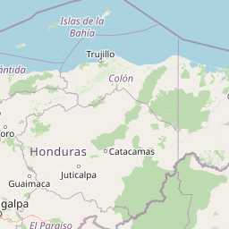
Map view of Río Plátano Biosphere Reserve

Use this park location map to pinpoint Río Plátano Biosphere Reserve in Honduras, understand its exact geographic position, and read its mapped placement within the surrounding landscape more clearly.

Pigeon | © OpenStreetMap contributors

Location context for Río Plátano Biosphere Reserve

Gracias a Dios Department
Recorded earthquake history

Review the Río Plátano Biosphere Reserve Earthquake History Collection

Explore historical seismic data associated with this protected area through an organized catalogue of recorded events. Provided by MoriAtlas, this resource allows for a clear look at regional activity patterns near the Río Plátano landscape without predictive modeling or hazard reporting.

Río Plátano Biosphere Reserve Earthquake History

Catalogued events

7 events

Strongest magnitude

Magnitude 5.3

Most recent event

Feb 15, 2023

This history includes earthquakes recorded inside the park or within 50 km of its borders

Visual reference collection for coastal mangroves, rainforest habitats, and interior mountain terrain

Rio Platano Biosphere Reserve Landscape Photos and Protected Area Scenery

Examine detailed photographs documenting the lowland rainforests, coastal lagoons, and rugged interior mountains defining the Rio Platano Biosphere Reserve. Visual reference collections reveal the complex topography and diverse ecological habitats characterizing this protected conservation landscape.

An aerial shot of a winding, muddy brown river flowing through a lush, green tropical rainforest valley with hilly, forest-covered terrain in the background.

An aerial view of two prominent green forested peaks rising above a dense tropical rainforest canopy.

Park atlas

Compare surrounding regional geography and adjacent conservation corridors

Parks Near Río Plátano Biosphere Reserve and Connected Protected Landscapes

Continue exploring protected areas linked to the broader Mesoamerican Biological Corridor and neighboring tropical watersheds. Comparing these regional conservation landscapes reveals shared ecological patterns across the Caribbean slope.
National parkHonduras
Park boundaries overlap#1 closest

Southwest

Patuca National Park National Park: Understanding its Mapped Protected Boundaries and Honduran Geography

Explore the protected landscape and regional setting of this Honduran park.

Patuca National Park is an important protected area within Honduras, offering a unique opportunity to study its geographic features and conservation significance. As a national park, it provides a critical anchor for understanding regional landscape patterns and mapped protected boundaries in Central America. This entity within the MoriAtlas helps users grasp the specific geographic context and natural terrain associated with Patuca National Park, facilitating detailed atlas-based exploration of its protected status and landscape character.

Area
3,755.84 km²
Established
1999
IUCN
II
Scope
Terrestrial
A horizontal watercolor painting showing layers of distant misty mountains behind a foreground of dense tropical foliage and palm-like plants.
Biosphere reserveJinotega Department
25 km away#2 closest

South

Bosawás Biosphere Reserve: Mapping Tropical Rainforest Landscapes and Regional Geography

Extensive primary forest and mountainous terrain in Nicaragua

Examine the geographic layout and protected boundaries of Bosawás Biosphere Reserve. Spanning nearly 20,000 square kilometers across Jinotega Department, this massive biosphere reserve includes the Saslaya massif and essential watersheds, serving as a critical study of tropical rainforest preservation and complex highland topography.

Area
20,000 km²
Established
1997
IUCN
IV
Relief
Mountain
National parkHonduras
About 37 km away#3 closest

Southwest

Sierra de Agalta National Park: National Park within Honduras's Protected Landscape Atlas

Explore mapped boundaries and natural terrain details.

Sierra de Agalta National Park is a protected national park in Honduras, offering valuable insight into the country's natural geography and conservation efforts. As a key entity within the broader atlas of protected lands, this park's mapped boundaries and surrounding terrain provide a foundation for understanding its ecological significance and regional context. Discover the geographic identity of Sierra de Agalta National Park and its contribution to Honduras's protected areas.

Area
207.85 km²
Established
1987
IUCN
II
Relief
Mountain
National parkColón Department
About 79 km away#4 closest

West

Capiro Calentura National Park: Honduran National Park Atlas and Protected Landscape

Discover mapped geography and protected area context in Colón Department.

Access detailed geographic information and mapped boundaries for Capiro Calentura National Park, a key protected area within Honduras' Colón Department. This entry offers an atlas-style perspective on the park's landscape and its regional setting, supporting structured discovery of national parks and conservation lands.

Area
80.82 km²
Established
1992
IUCN
II
Climate
Tropical
National parkLa Unión
About 126 km away#5 closest

West

La Muralla National Park: Honduras National Park Geography and Mapped Boundaries

Explore the protected landscape and regional context.

La Muralla National Park represents a significant protected landscape within Honduras, offering valuable geographic data for atlas exploration. As a national park, its mapped boundaries and regional setting are key to understanding its conservation significance. This entry provides structured insight into the park's physical characteristics and its place within the broader Honduran geography, ideal for detailed landscape analysis.

Area
210.35 km²
Established
1993
IUCN
II
Scope
Terrestrial
National parkAtlántida Department
140 km away#6 closest

West

Pico Bonito National Park: Honduran National Park with Mapped Protected Boundaries

Explore its geographic setting and protected landscape identity.

Pico Bonito National Park represents a vital protected area within Honduras, situated in the Atlántida Department. This canonical page focuses on its precise geographic features and the extent of its protected landscape. Users can engage with detailed map-based information and understand the park's significance within the broader context of Honduran geography and conservation atlas data.

Area
564.3 km²
Established
1987
IUCN
II
Relief
Mountain
National parkRoatán
About 149 km away#7 closest

West

Port Royal National Park National Park: Mapped Protected Landscape on Roatán

Explore its geographic context and park boundaries.

Port Royal National Park, situated on Roatán, Honduras, offers a distinct protected landscape for geographic exploration. As a National Park, its mapped boundaries define a significant area for understanding regional geography and conservation landscapes. Discover the park's identity through its position within Roatán and its contribution to a structured atlas of protected natural areas.

Area
5 km²
Established
2010
IUCN
II
Climate
Tropical
National parkHonduras
About 169 km away#8 closest

West

Montaña de Yoro National Park: Honduran National Park Atlas and Protected Landscape Exploration

Understanding its mapped boundaries and regional geography.

This card details Montaña de Yoro National Park, a designated national park in Honduras, offering a focused look at its protected landscape. It provides essential geographic context, helping users to understand the park's mapped boundaries and its significance within the broader atlas of Honduran protected areas. Explore the specific terrain and regional setting that define Montaña de Yoro National Park.

Area
154.8 km²
Established
1987
IUCN
II
Relief
Mountain

Common questions about visiting, size, designation, and location context for Río Plátano Biosphere Reserve

Río Plátano Biosphere Reserve FAQs for park facts, access, geography, and protected area context

Find quick answers about Río Plátano Biosphere Reserve, including protected-area facts, park geography, trail and visitor context, and how the park fits into its surrounding country and regional landscape.
MoriAtlas Explorer

Continue Your Protected Areas Search Across the Global Atlas

Deepen your exploration by continuing the structured search for national parks and protected areas worldwide. Utilize the comprehensive filtering capabilities to compare different conservation landscapes and refine your understanding of global park geography. Discover more about the distribution and characteristics of protected natural areas.

Global natural geography
