Mori Atlas logo
National parkRocky Mountain National Park

Discover the mapped boundaries and regional geographic context of this protected natural area.

Rocky Mountain National Park: Colorado's Premier National Park Protected Landscape

Rocky Mountain National Park stands as a significant protected natural area within Colorado, offering an essential locus for atlas-based exploration of US National Parks. This page details the park's geographic identity, focusing on its mapped boundaries and the surrounding landscape context relevant to understanding its protected status. It serves as a gateway to exploring the park's natural terrain and its role within the broader regional geography of Colorado, providing a factual overview for those interested in conservation landscapes and mapped natural features.

Alpine TundraMountain RangesGlacial LakesElk WildlifeContinental DivideWorld Biosphere Reserve

Rocky Mountain National Park

National park

Park overview

Structured park overview, official facts, and landscape profile for Rocky Mountain National Park

Rocky Mountain National Park park facts, protected area profile, and essential visitor context

Review the core facts for Rocky Mountain National Park, including designation, size, terrain, visitor scale, habitats, and operating context in one park-focused overview.

About Rocky Mountain National Park

Rocky Mountain National Park protects one of the most iconic landscapes in the American West, a vast wilderness of granite peaks, glacial valleys, and alpine lakes that exemplifies the grandeur of the Rocky Mountains. The park's location along the Continental Divide places it at a critical hydrological boundary, where waters originating within its boundaries eventually reach both the Pacific and Atlantic Oceans. The terrain showcases the powerful forces that shaped these mountains, with glacial carving visible in the U-shaped valleys, hanging cirques, and the remaining glaciers that persist in highelevation shadowed basins. Beyond its natural significance, the park represents over a century of conservation advocacy, with Enos Mills, James Grafton Rogers, and J. Horace McFarland among the key figures who championed protection of this landscape. The park is surrounded by national forest lands on all sides, creating an extensive complex of protected wilderness that extends beyond the official boundaries.

Quick facts and research context for Rocky Mountain National Park

Located approximately 55 miles northwest of Denver, Rocky Mountain National Park occupies territory within Larimer, Grand, and Boulder counties. The park contains 60 peaks exceeding 12,000 feet, with Longs Peak at 14,259 feet being the highest summit. Trail Ridge Road reaches 12,183 feet, making it the highest continuously paved highway in the United States. The park protects the headwaters of the Colorado River in its northwestern region and encompasses roughly 450 miles of streams, 350 miles of trails, and 150 lakes. Five visitor centers serve the public, with headquarters at the Beaver Meadows Visitor Center, a National Historic Landmark designed by the Frank Lloyd Wright School of Architecture.

Protection and recognition

Documenting terrestrial designation history and official conservation framework since 1976

Rocky Mountain National Park Protection Status and Conservation Profile

Geographic records trace the official terrestrial protection status of Rocky Mountain National Park dating back to its key designation in 1976. Analyzing such factual designations highlights the historical management scope and official classification of the North American mountain reserve.

Protection details

Protection scope
Terrestrial
Designated year
1976
Park context

Deeper park guide and search-rich context for Rocky Mountain National Park

Rocky Mountain National Park history, landscape, wildlife, and travel context

Explore Rocky Mountain National Park through its history, landscape character, ecosystems, wildlife, conservation priorities, cultural context, and seasonal travel timing in a structured park guide built for atlas discovery and search intent.

Why Rocky Mountain National Park stands out

Rocky Mountain National Park is renowned for its spectacular alpine scenery, with dramatic mountain vistas, glacial cirques, and tundra landscapes that define the high Rocky Mountains. The park is famous for Trail Ridge Road, an engineering marvel that traverses the Continental Divide and offers visitors access to environments ranging from verdant montane forests to windswept alpine tundra. The park's population of approximately 2,000 to 3,000 elk makes it one of the best places in the country to observe these large mammals, particularly during the autumn rut. The diversity of ecosystems across elevation gradients, from riparian corridors to krummholz zones, provides exceptional ecological variety within a single protected area.

Rocky Mountain National Park history and protected-area timeline

The history of human presence in what is now Rocky Mountain National Park extends back thousands of years, with Paleo-Indians traveling routes near present-day Trail Ridge Road to hunt and forage. Ute and Arapaho peoples subsequently used the area for hunting and camping before settlers began arriving in the mid-1800s, displacing Native Americans by 1878. The region experienced brief mining booms in the 1870s with the establishment of Lulu City, Dutchtown, and Gaskill in the Never Summer Mountains, though the boom ended by 1883. The arrival of the railroad in Lyons in 1881 and completion of the Big Thompson Canyon Road in 1904 opened the area to more visitors. The campaign to establish a national park gained momentum in the early 20th century, with Enos Mills from Estes Park leading the effort alongside James Grafton Rogers from Denver and J. Horace McFarland of Pennsylvania. President Woodrow Wilson signed the Rocky Mountain National Park Act on January 26, 1915, formalizing protection. The Civilian Conservation Corps constructed Trail Ridge Road in the 1930s, creating the main automobile route across the park. In 1976, UNESCO designated the park as one of the original World Biosphere Reserves.

Rocky Mountain National Park landscape and geographic character

The physical landscape of Rocky Mountain National Park is defined by the dramatic topography of the Front Range, where glaciated peaks rise sharply from valley floors carved by ancient ice sheets. The Continental Divide runs north-south through the park's center, with the Mummy Range containing several thirteeners on the north side including Hagues Peak, Mummy Mountain, Fairchild Mountain, Ypsilon Mountain, and Mount Chiquita. The Never Summer Mountains in the west feature a horseshoe-shaped bend in the Continental Divide that creates a unique hydrological anomaly. Elevations range from 7,860 feet at the lowest points to 14,259 feet at Longs Peak, the park's highest point. Approximately 450 miles of rivers and streams traverse the landscape, fed by snowmelt and precipitation that varies significantly between the wetter western slopes and drier eastern approaches. Several small glaciers and permanent snowfields persist in high mountain cirques, remnants of the more extensive glacial systems that once filled these valleys.

Rocky Mountain National Park ecosystems, habitats, and plant life

The ecological diversity of Rocky Mountain National Park stems from its dramatic elevation range, which supports four distinct ecosystem zones that transition from valley floors to alpine tundra. The montane zone, between 5,600 and 9,500 feet, features ponderosa pine forests, Douglas fir, lodgepole pine, and quaking aspens, with wide meadow valleys supporting diverse plant communities. The subalpine zone, from 9,000 to 11,000 feet, is dominated by Engelmann spruce and subalpine fir, with the characteristic krummholz formation occurring near tree line where wind shapes trees into twisted shapes. Above 11,000 feet, the alpine tundra zone supports only the most hardy plants, including cushion plants, grasses, sedges, and dwarfed flowering plants adapted to extreme conditions. The riparian zone runs through all elevation bands, following streams and rivers with willows, alders, and water birch creating important habitat corridors.

Rocky Mountain National Park wildlife and species highlights

Rocky Mountain National Park supports remarkable wildlife diversity, with nearly seventy mammal species and almost three hundred bird species documented within its boundaries. The park is particularly known for its elk population of approximately 2,000 to 3,000 in summer, with 800 to 1,000 remaining through winter, making elk the most commonly observed large mammal. Other ungulates include bighorn sheep, mule deer, and moose, with the bighorn sheep population having recovered to an estimated 350 animals. Predators present include cougars, coyotes, Canada lynx, black bears, and bobcats, though wolves, wolverines, and grizzly bears have been extirpated from the area. The bird population includes species adapted to each ecosystem zone, from mountain chickadees and Steller's jays in subalpine forests to white-tailed ptarmigans and prairie falcons in the tundra. The elk rut in autumn draws many visitors who come to witness the bugling and territorial displays of these impressive animals.

Rocky Mountain National Park conservation status and protection priorities

Rocky Mountain National Park was designated as a World Biosphere Reserve by UNESCO in 1976, recognizing its significance as a protected area for scientific research, conservation, and environmental education. The park serves as an outdoor laboratory for studying ecosystem dynamics, climate change impacts, and biodiversity patterns across elevation gradients. Research and monitoring programs focus on ungulate ecology, high-altitude revegetation, acid precipitation effects, and aquatic ecosystem management. The park faces ongoing conservation challenges, including impacts from air pollution originating on the Front Range, climate change effects on snowpack and fire regimes, and management of the elk population that has grown large enough to cause overgrazing concerns in riparian areas. Mountain pine beetle outbreaks have caused significant tree mortality, and the park participates in climate change studies in cooperation with NASA and the academic scientific community.

Rocky Mountain National Park cultural meaning and human context

The area now within Rocky Mountain National Park has been inhabited by indigenous peoples for thousands of years, with Ute and Arapaho peoples historically hunting and camping in the region before European American settlement. The landscape holds significance in the cultural history of Colorado, with the establishment of the park representing one of the early successful conservation movements in the American West. The Beaver Meadows Visitor Center, designed by the Frank Lloyd Wright School of Architecture at Taliesin West, represents significant architectural heritage and is designated as a National Historic Landmark. The park's establishment in 1915 reflected growing appreciation for the Rocky Mountains as a distinctive American landscape worthy of protection, part of a broader movement that would eventually create the national park system we know today.

Top sights and standout views in Rocky Mountain National Park

Rocky Mountain National Park offers visitors access to some of the most spectacular alpine scenery in North America, with Trail Ridge Road providing a scenic crossing of the Continental Divide at elevations exceeding 12,000 feet. The park's alpine lakes, including Bear Lake, Sprague Lake, and Odessa Lake, occupy glacial cirques and provide iconic mountain vistas. Longs Peak, at 14,259 feet, presents a challenging mountaineering objective for experienced climbers seeking to summit one of Colorado's fourteeners. The elk herds, particularly visible during autumn rutting season, represent one of the best wildlife viewing opportunities in any national park. The diversity of ecosystems, from riparian corridors to alpine tundra, creates remarkable ecological variety within a single protected area.

Best time to visit Rocky Mountain National Park

Rocky Mountain National Park offers distinct seasonal experiences, with summer providing the most accessible conditions for hiking and scenic driving along Trail Ridge Road, though afternoon thunderstorms are common. The subalpine zone does not experience spring-like conditions until June, with wildflowers blooming from late June through early August. Fall brings the elk rut, drawing visitors to witness the dramatic displays, though October can bring significant snow to higher elevations. Winter transforms the park into a backcountry wilderness with extreme conditions, as arctic conditions prevail with sudden blizzards, high winds, and deep snowpack. Trail Ridge Road closes for the winter season due to heavy snow, limiting motorized access. The park implemented a timed-entry reservation system from May to October to address crowding concerns.
Park guides

Targeted planning resources addressing seasonal high altitude access and wildlife viewing

Rocky Mountain National Park Focused Guide Preview and Visitor Timing Answers

Selected published guides provide structured answers for navigating high altitude terrain across changing seasonal conditions. Material focuses directly on determining optimal visitor timing by weighing road accessibility against autumn elk viewing opportunities.
Monthly climate preview

Analyzing thirty-year temperature ranges and precipitation trends in the Colorado Rockies

Rocky Mountain National Park Climate Normals and Monthly Weather Patterns

Long-term data recorded at 2669 meters elevation shows average monthly temperatures ranging from sub-zero winter lows to warm mid-year maximums alongside variable precipitation. Analyzing the full twelve-month profile reveals the historical shifts in temperature extremes and moisture patterns that shape Rocky Mountain National Park.
Annual mean3 °C
-7 °C17 °C
Jan-7°
Feb-7°
Mar-3°
Apr
May
Jun13°
Jul17°
Aug15°
Sep11°
Oct
Nov-3°
Dec-7°
Warmest month
July

16.7 °C

Coolest month
January

-7.5 °C

Wettest month
April

2.3 mm/day

Driest month
December

1.1 mm/day

Park location guide

Geography guide, regional context, and park location map for Rocky Mountain National Park

Rocky Mountain National Park park geography, regions, and map view in United States of America

Understand where Rocky Mountain National Park sits in United States of America through a broader geographic reading of the surrounding landscape, nearby location context, and its mapped position within the national park landscape.

How Rocky Mountain National Park fits into United States of America

The United States of America is a federal presidential republic and one of the world's largest countries by area and population. It consists of 50 states across a vast territory spanning multiple time zones, with its capital in Washington, D.C. and largest city in New York City. The nation has a diverse economy, influential political system, and significant cultural and military presence globally.

Wider geography shaping Rocky Mountain National Park in United States of America

The United States occupies a vast territory in North America, bordered by Canada to the north and Mexico to the south. The 48 contiguous states stretch from the Atlantic to the Pacific Ocean, while Alaska occupies the northwestern region and Hawaii is an archipelago in the Pacific. The country encompasses diverse terrain including the Rocky Mountains, Appalachian Mountains, Great Plains, and extensive river systems.

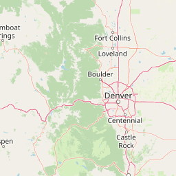
Map view of Rocky Mountain National Park

Use this park location map to pinpoint Rocky Mountain National Park in United States of America, understand its exact geographic position, and read its mapped placement within the surrounding landscape more clearly.

Pigeon | © OpenStreetMap contributors

Location context for Rocky Mountain National Park

Colorado
Natural feature types

Explore the Named Natural Features of Rocky Mountain National Park

Continue geographic discovery by analyzing the specific natural features that compose the Rocky Mountain National Park landscape. MoriAtlas provides a structured look at the mountain peaks, alpine lakes, and glacial systems defining this high-altitude region, offering deeper context for mapped protected areas.
Park atlas

Compare alpine landscapes and diverse ecosystems across the Front Range, tracing connected protected areas in the region.

Explore Nearby National Parks and Protected Areas: A Geographic Companion to Rocky Mountain National Park

After exploring Rocky Mountain National Park, browse other national parks and protected areas showcasing similar alpine tundra, mountain ranges, and subalpine forests across the surrounding Rocky Mountain region. Compare diverse conservation landscapes, map regional park geography, and trace the spread of protected wilderness areas to understand their connected environmental contexts.
Protected landscapeGrand County
Park boundaries overlap#1 closest

South

Arapaho National Recreation Area: Geographic Profile and Protected Landscape Context

High-country mountain reservoirs and forested mountain terrain

The Arapaho National Recreation Area defines a unique intersection of montane forest and water-based geography in Grand County, Colorado. As the home to the Great Lakes of Colorado, this protected landscape provides a critical connection point between the Colorado River headwaters and the Continental Divide. Examine the park's terrain, reservoir distribution, and its role as a forested gateway to the neighboring mountain regions.

Area
124.2 km²
Established
1978
Relief
Mountain
Climate
Alpine
Wildlife reserveColorado
Park boundaries overlap#2 closest

Southeast

Indian Peaks Wilderness: Alpine Geography and Front Range Protected Landscapes

Mapping high country summits and glacial basins in Colorado

Indian Peaks Wilderness stands as a signature wildlife reserve along the Colorado Continental Divide. This atlas entry focuses on its complex system of thirteen-thousand-foot peaks, relict glaciers, and interconnected alpine lakes that define the Front Range. Gain insight into the protected boundaries and glacial geomorphology that characterize this high-country landscape near the Denver metropolitan region.

Area
310.44 km²
Established
1978
IUCN
Ib
Relief
Mountain
Wildlife reserveColorado
Park boundaries overlap#3 closest

West

Never Summer Wilderness: Protected Mountain Geography and Alpine Terrain in Colorado

High-altitude wilderness along the Continental Divide

Spanning over 21,000 acres, the Never Summer Wilderness defines a critical segment of the Colorado Rockies. This protected area features a jagged skyline of 12,000-foot summits, extensive alpine tundra, and the remarkable old-growth spruce and fir forests of Bowen Gulch. Use these maps to understand its role as a vital headwater landscape and its position as a sanctuary for alpine wildlife and ecosystems.

Area
85.3 km²
Established
1980
IUCN
Ib
Relief
Mountain
Protected landscapeColorado
Park boundaries overlap#4 closest

North

Roosevelt National Forest: Mapping Wilderness and Protected Landscapes in Northern Colorado

Regional geography, river corridors, and alpine mountain terrain

Roosevelt National Forest encompasses a significant protected landscape across Larimer, Boulder, Gilpin, and Jefferson counties. The forest features a complex terrain of deep canyons, forested plateaus, and protected wilderness areas that form a scenic buffer along the eastern side of the Continental Divide and Rocky Mountain National Park.

Area
3,293.33 km²
Established
1902
Relief
Mountain
Climate
Subpolar
Wildlife reserveColorado
About 34 km away#5 closest

South

James Peak Wilderness: Geographic Profile and Protected Landscape Mapping

High elevation terrain in the Colorado Rockies

James Peak Wilderness provides a critical protected landscape featuring dramatic alpine summits, U-shaped glacial valleys, and subalpine meadows. Its geographic structure forms an essential ecological link along the Colorado Front Range, characterized by high-elevation peaks, dense coniferous forests, and diverse tundra ecosystems situated immediately east of the Continental Divide.

Area
68.86 km²
Established
2002
IUCN
Ib
Wildlife reserveColorado
53 km away#6 closest

Southwest

Eagles Nest Wilderness: Alpine Geography and Protected Landscape of the Colorado Gore Range

High-mountain protected area in the White River National Forest

Spanning the southern Gore Range, Eagles Nest Wilderness represents a core protected landscape in Colorado characterized by high-elevation peaks, glacial cirque lakes, and extensive backcountry trail networks. Its geography bridges the gap between deep coniferous forests and exposed alpine tundra, maintaining significant ecological and historical value within the mountainous terrain of Eagle and Summit Counties.

Area
546.79 km²
Established
1976
IUCN
Ib
Relief
Mountain
Protected areaColorado
54 km away#7 closest

South

Mount Evans Wilderness: Alpine Landscapes and Protected Geography in Colorado

Glacial cirques and high-altitude wilderness ecosystems.

Mount Evans Wilderness offers a premier look at the Colorado Front Range, defined by its dramatic relief, sheer cliff lines, and extensive glacial history. This entry examines the wilderness as a protected zone that transitions from montane forests to tundra, providing a reference for high-elevation mountainous geography within the United States.

Area
301.09 km²
Established
1980
IUCN
Ib
Relief
Mountain
Protected areaColorado
60 km away#8 closest

South

Pike National Forest: Protected Mountain Landscapes and Regional Geography in Central Colorado

Granite peaks, montane forests, and diverse alpine terrain

Spanning from the rolling foothills of the Front Range to the high alpine summits of the Rocky Mountains, Pike National Forest is a significant protected area defined by its unique Pikes Peak granite bedrock and deep river-carved canyons. This analysis provides a structured look at its expansive wilderness boundaries, drainage basins, and the vertical transitions that characterize this vital central Colorado highland.

Area
4,478.27 km²
Established
1892
Relief
Mountain
Climate
Alpine

Common questions about visiting, size, designation, and location context for Rocky Mountain National Park

Rocky Mountain National Park FAQs for park facts, access, geography, and protected area context

Find quick answers about Rocky Mountain National Park, including protected-area facts, park geography, trail and visitor context, and how the park fits into its surrounding country and regional landscape.
MoriAtlas Explorer

Continue Your Protected Areas Search Across the Global Atlas

Deepen your exploration by continuing the structured search for national parks and protected areas worldwide. Utilize the comprehensive filtering capabilities to compare different conservation landscapes and refine your understanding of global park geography. Discover more about the distribution and characteristics of protected natural areas.

Global natural geography