

Mori Atlas logo
Nature reserveRybník Motovidlo

Discover the geographic boundaries and ecological heritage of this significant aquatic habitat

Rybník Motovidlo Nature Reserve: Mapping the Protected Wetland Landscapes of South Bohemia

(Přírodní památka Rybník Motovidlo)

Rybník Motovidlo is a vital nature reserve located within the flat České Budějovice Basin of the Czech Republic. Spanning 11.6 hectares, this protected pond represents an essential node in the South Bohemian pond landscape, supporting a critically endangered population of aquatic plants and an extensive community of native amphibian species. As part of a larger bird protection area, the site demonstrates how centuries of human-managed water systems intersect with contemporary conservation goals and unique regional geomorphology.

fishpondSouth Bohemian pond landscapeaquatic plantsamphibiansnatural monumentNatura 2000
A flat vector illustration of a mountainous valley with a winding river, a prominent waterfall, pine trees, and a sun in the sky.

Rybník Motovidlo

Nature reserve

Park overview

Structured park overview, official facts, and landscape profile for Rybník Motovidlo

Rybník Motovidlo park facts, protected area profile, and essential visitor context

Review the core facts for Rybník Motovidlo, including designation, size, terrain, visitor scale, habitats, and operating context in one park-focused overview.

About Rybník Motovidlo

Rybník Motovidlo is a small protected fishpond located in the South Bohemian Region of the Czech Republic, in the district of České Budějovice and immediately south of the village of Čejkovice. Although it is modest in size, the pond occupies an important place in the regional conservation network, particularly because of its rare aquatic flora and its exceptionally rich amphibian fauna.

Ecologically, the site belongs to the České Budějovice Basin, a broad flatland shaped by tectonic subsidence and long-standing human management of water. The surrounding pond system includes more than twenty water bodies of varying size, forming a connected mosaic of open water, littoral zones, and buffer habitats. Within this mosaic, Motovidlo stands out as a refuge for species that have become scarce elsewhere in intensively used agricultural countryside. Its shallow profile, with a maximum depth of about 2.5 meters and an average depth of around half a meter, creates favorable conditions for emergent and floating aquatic vegetation, a key structural element for amphibians and invertebrates.

Administratively, Rybník Motovidlo is a national natural monument (přírodní památka) as designated under Czech conservation law. It was registered as a Site of Community Importance in 2009 and was formally elevated to national protection status by the South Bohemian Regional Authority in December 2022. The pond is part of the broader Českobudějovické rybníky Bird Protection Area, a designation that connects it with one of the most important wetland bird regions in Central Europe. Together with other nearby ponds, it contributes to a landscape that combines centuries-old fish-farming traditions with modern biodiversity conservation goals.

Quick facts and research context for Rybník Motovidlo

Rybník Motovidlo is a natural monument (přírodní památka) in the South Bohrian Region, situated south of Čejkovice in the České Budějovice district. Its total area is 11.6 hectares, with the usable water surface covering about 6.13 hectares and a littoral zone of around 1.4 hectares. The pond lies in the České Budějovice Basin, specifically in the Blatská pánev subunit and the Zlivská pánev district.

The site was declared a Site of Community Importance in 2009 under the name Rybník Motovidlo with an area of 11.59 hectares, and was later formally declared a national-level natural monument at the end of 2022. The pond is part of the Českobudějovické rybníky Bird Protection Area. It belongs to a complex system of more than twenty South Bohemian ponds and is managed for fish, primarily carp, by Rybářství Třeboň.

Protection and recognition

Documented terrestrial protection scope and official designation records

Rybník Motovidlo Protection Status and Natura 2000 Recognition Details

Rybník Motovidlo maintains documented terrestrial protection status supported by official Natura 2000 recognition records. Structured administrative facts provide verifiable baseline data regarding conservation designations and management scope.

International recognition

Protection details

Protection scope
Terrestrial
Transboundary protection
No
Park context

Deeper park guide and search-rich context for Rybník Motovidlo

Rybník Motovidlo history, landscape, wildlife, and travel context

Explore Rybník Motovidlo through its history, landscape character, ecosystems, wildlife, conservation priorities, cultural context, and seasonal travel timing in a structured park guide built for atlas discovery and search intent.

Why Rybník Motovidlo stands out

Rybník Motovidlo is best known as a conservation site for the critically endangered aquatic plant known in Czech as plavín štítnatý (Nymphoides peltata), whose population at the pond experienced a dramatic decline between 2018 and 2019. The site is also notable as a refuge for a diverse community of amphibians, including species protected under Czech and European nature law. Beyond its individual rarity, the pond is significant as part of the South Bohemian pond landscape, a cultural and ecological system where artificial fishponds have shaped biodiversity for centuries. Within this system, Rybník Motovidlo represents a small-scale but ecologically valuable node where rare aquatic flora and amphibian fauna converge.
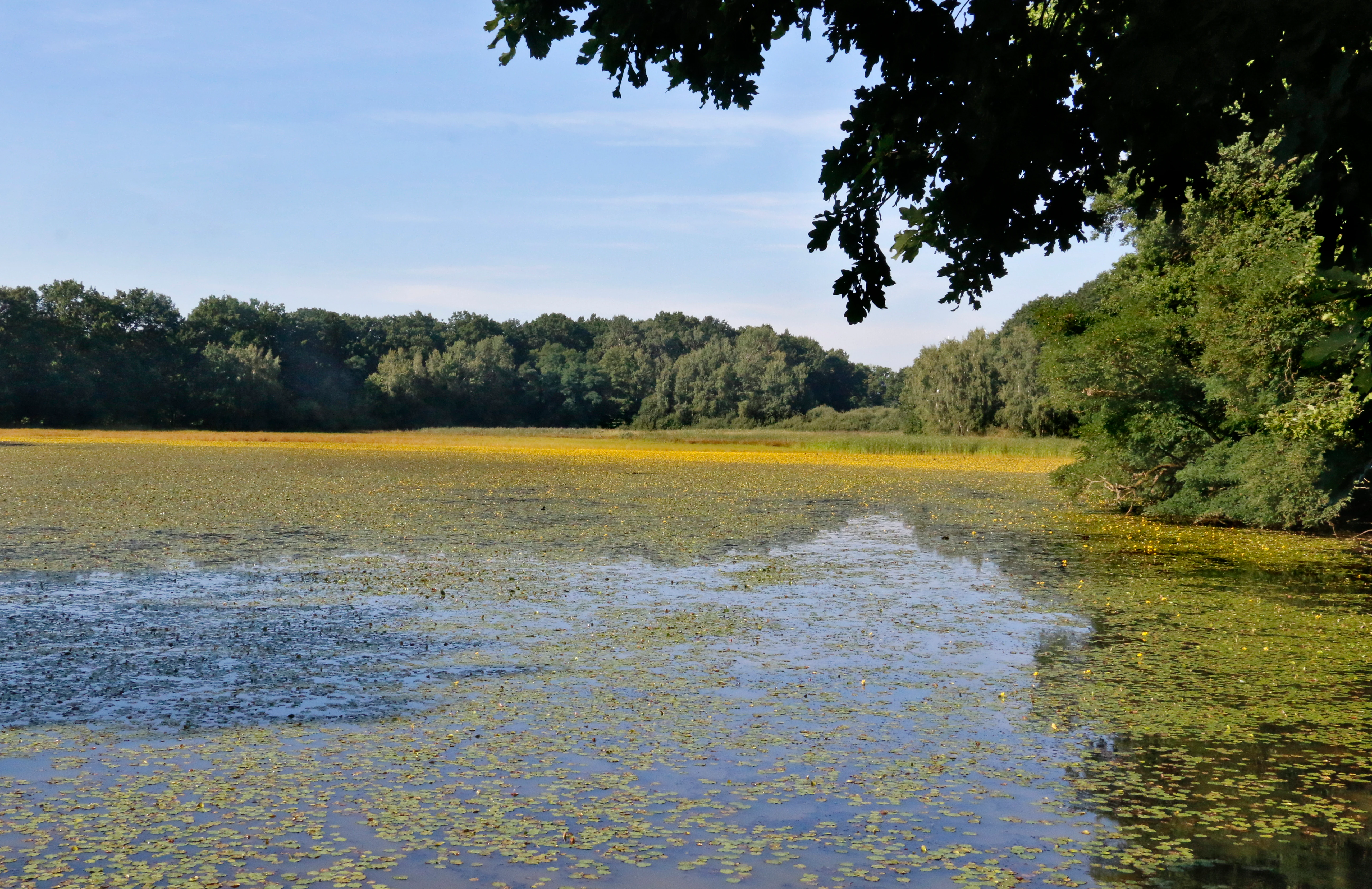
A wide view of Motovidlo pond with a blanket of floating yellow aquatic plants, bordered by dense deciduous forest under a clear sky.
The Motovidlo pond, a wetland nature reserve featuring extensive surface vegetation.

Rybník Motovidlo history and protected-area timeline

The formal protection history of Rybník Motovidlo began within the framework of European Union nature policy. In 2009, the area was designated as a Site of Community Importance under the name Rybník Motovidlo, recognizing its value for threatened habitats and species within the Natura 2000 network. The declaration area at that stage covered 11.59 hectares.

National-level protection came more than a decade later. On 24 December 2022, the South Bohemian Regional Authority formally established Rybník Motovidlo as a přírodní památka, or natural monument, in IUCN Category III. This step translated the existing European-level recognition into a domestic protective designation, giving the site a stronger legal framework for habitat management and species conservation. The national designation uses a very similar boundary, reflecting continuity between the European and the Czech protection regimes rather than a significant territorial change.

Rybník Motovidlo landscape and geographic character

Rybník Motovidlo lies within the České Budějovice Basin, more specifically in the Blatská pánev subunit and the Zlivská pánev district of the Czech geomorphological system. Geologically, the basin floor is built from Upper Cretaceous sediments dominated by kaolinitic sandstones, conglomerates, mudstones, and siltstones. These are overlain by Pleistocene loess loams and by Holocene fluvial and water-body deposits associated with the pond system itself.

The dominant landforms around the pond are not natural in origin but result from centuries of fishpond construction. Anthropogenic pond dams are the most conspicuous relief features in the landscape, and the broader terrain reflects tectonically controlled subsidence modified by erosion and denudation. The surrounding soils are primarily primary pseudogley, while inside the protected area the characteristic soil is typical gley, reflecting the influence of standing water. These soil conditions, together with a moderately warm climate (Quitt classification MT11) receiving 600 to 750 millimeters of annual precipitation, support the pond's characteristic hydrological regime and its narrow belt of fringing wetland vegetation.
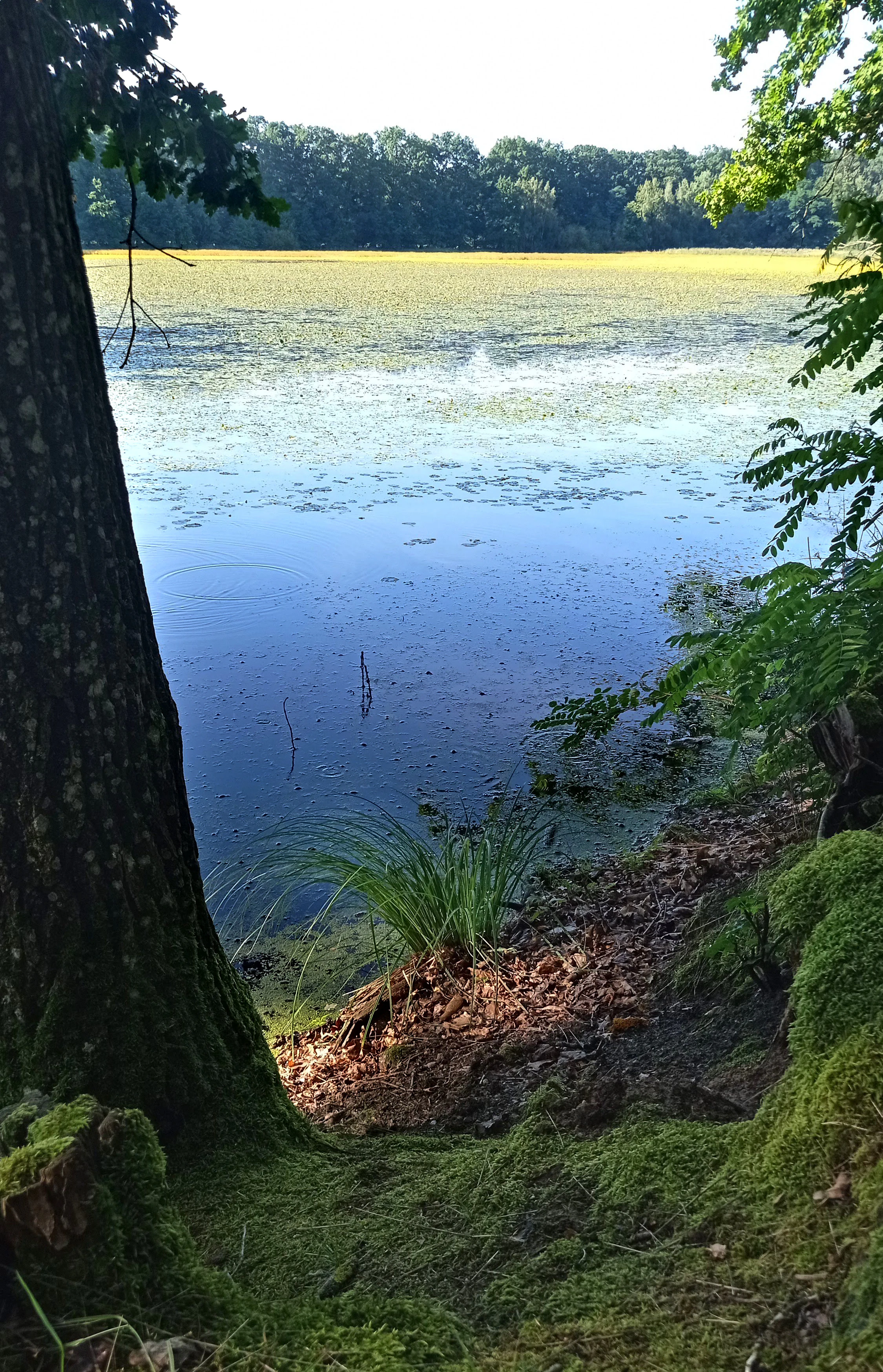
A serene pond framed by trees and mossy banks, with vegetation covering the water surface.
A view of the Motovidlo pond near the village of Čejkovice, showcasing the wetland habitat.

Rybník Motovidlo ecosystems, habitats, and plant life

The natural character of Rybník Motovidlo is defined by its status as a representative of standing-water communities (vegetace stojatých vod), with the central focus being a population of the aquatic plant known in Czech as plavín štítnatý. This species, the primary subject of conservation at the site, has shown a dramatic fluctuation in cover, declining from a substantial share of the water surface in 2018 to only a small fraction by 2019.

Beyond the primary species, the pond and its margins harbor a suite of other rare and threatened plants associated with nutrient-poor to moderately eutrophic standing waters and their banks. These include species of stonewort-margin sedges, aquatic bladderworts, and wetland speedwells. Together they form the vegetation mosaic that supports the site's amphibian fauna and contributes to its value within the regional pond network. The protected area's ecological logic lies in this combination of aquatic plant communities, shallow open water, and transitional shoreline habitats, which together sustain a disproportionately diverse animal community for a pond of this size.
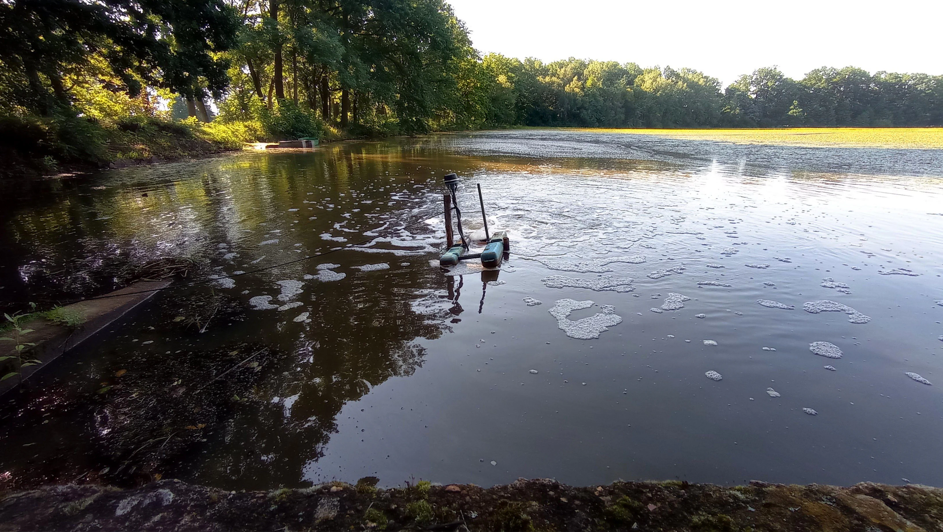
A calm, dark-water pond surrounded by trees, with a small mechanical aerator creating ripples in the center.
An aeration device operating on the surface of Rybník Motovidlo during summer.

Rybník Motovidlo wildlife and species highlights

The most prominent faunal value of Rybník Motovidlo lies in its amphibian assemblage. The pond and its immediate surroundings provide breeding habitat for several species that are included among the formal subjects of protection at the site.

Among the documented species are the smooth newt (Lissotriton vulgaris), the common toad (Bufo bufo), the European green toad (Bufotes viridis), the pool frog (Pelophylax lessonae), the edible frog (Pelophylax esculentus), the agile frog (Rana dalmatina), the European tree frog (Hyla arborea), and the European fire-bellied toad (Bombina bombina). The simultaneous presence of such a varied amphibian community is one of the defining conservation features of the site, and multiple species recorded here are listed in Czech Red Lists and in relevant European nature directives.

Through its integration into the Českobudějovické rybníky Bird Protection Area, the pond also contributes to the conservation of wetland and waterbird species using the broader pond complex, although the site's own designation focuses on aquatic vegetation and amphibians.

Rybník Motovidlo conservation status and protection priorities

Rybník Motovidlo is a conservation site whose significance is rooted in its combination of threatened aquatic vegetation and amphibian fauna within a functioning cultural pond landscape. The site was accepted into the Natura 2000 network as a Site of Community Importance in 2009, an early signal of its recognized value for European priority habitats and species. Its elevation to a national natural monument in December 2022 strengthened its domestic protection framework and gave the responsible authorities clearer tools for habitat management.

The conservation focus at the pond is unusually specific: it centers on the stability of a single plant population, which experienced a sharp decline between 2018 and 2019 for reasons that are not fully understood. Protecting this population and preventing further loss is the explicit objective of management at the site. Maintaining the hydrological and water-quality characteristics that support the broader aquatic and amphibian community is also central, particularly given that the pond is operated for commercial fish production by Rybářství Třeboň. The broader conservation role of the site is anchored in its membership in the Českobudějovické rybníky Bird Protection Area, placing it within one of the key wetland conservation landscapes of the Czech Republic.

Rybník Motovidlo cultural meaning and human context

Although Rybník Motovidlo is primarily a nature conservation site, it sits within a landscape shaped by centuries of human water management. The České Budějovice Basin is one of the historical heartlands of South Bohemian fishpond cultivation, and the present-day network of more than twenty ponds around Čejkovice reflects centuries of dam construction, hydraulic engineering, and fish farming. The pond itself is currently operated by Rybářství Třeboň, a fisheries company that continues the regional tradition of carp aquaculture.

This long-standing human use of the landscape has, paradoxically, created the mosaic of shallow standing waters and temporary drawdowns that supports much of the region's rare biodiversity. The planned coexistence of commercial fish production and strict conservation management is therefore a defining aspect of the site's cultural and ecological context.

Top sights and standout views in Rybník Motovidlo

The strongest highlight of Rybník Motovidlo is its concentration of conservation value in a small area. Despite occupying only 11.6 hectares, it combines a critically endangered aquatic plant species, a remarkable eight-species amphibian community, and membership in one of Central Europe's most important wetland bird protection areas. The dramatic fluctuation in the population of its flagship plant species adds urgency to ongoing conservation effort.

Equally distinctive is the site's position within the South Bohemian pond landscape. Here, modern biodiversity protection is layered onto a centuries-old tradition of fishpond management, demonstrating how cultural land use and contemporary conservation goals can intersect in a single small water body.

Best time to visit Rybník Motovidlo

The seasonal character of Rybník Motovidlo is shaped by the temperate climate of the České Budějovice Basin, with average January temperatures around minus 2 to minus 3 °C and average July temperatures of about 16 to 17 °C. Late spring and the first half of summer are generally the most rewarding periods for observing amphibian activity around the pond, when breeding choruses and movement between water and land are most pronounced.

Late spring through early autumn also offers the best conditions for viewing the pond's aquatic vegetation, when floating-leaved species such as plavín štítnatý can, in favorable years, form a visible cover on parts of the water surface. Winter brings colder conditions with snow cover typically present for around fifty to sixty days per year, and the site then shifts into a quieter, more reflective landscape. Visitors interested primarily in the broader bird life of the connected pond system may find migration periods in spring and autumn particularly rewarding, although the natural monument itself is oriented toward plants and amphibians rather than birdwatching infrastructure.


Monthly climate preview

Measured temperature ranges and monthly precipitation patterns from representative coordinates

Rybník Motovidlo Climate Normals and Long-Term Weather by Month

Long-term data records reveal monthly temperature variations and precipitation distribution across the representative park coordinate. Reviewing the complete twelve-month normals provides detailed insight into annual climate patterns without relying on live forecasts.
Annual mean8 °C
-3 °C19 °C
Jan-3°
Feb-1°
Mar
Apr
May13°
Jun17°
Jul19°
Aug19°
Sep13°
Oct
Nov
Dec-2°
Warmest month
July

18.8 °C

Coolest month
January

-2.8 °C

Wettest month
July

3 mm/day

Driest month
February

1.1 mm/day

Park location guide

Geography guide, regional context, and park location map for Rybník Motovidlo

Rybník Motovidlo park geography, regions, and map view in Czechia

Understand where Rybník Motovidlo sits in Czechia through a broader geographic reading of the surrounding landscape, nearby location context, and its mapped position within the national park landscape.

How Rybník Motovidlo fits into Czechia

Czech Republic is a landlocked Central European country with a population of approximately 10.9 million people. The nation was established as an independent state on January 1, 1993, following the dissolution of Czechoslovakia. Its capital and largest city is Prague, with other major urban centers including Brno, Ostrava, Plzeň, and Liberec.

Wider geography shaping Rybník Motovidlo in Czechia

The Czech Republic is a landlocked country in Central Europe. It is bordered by Germany to the west, Austria to the south, Poland to the northeast, and Slovakia to the southeast. The landscape is predominantly hilly, with the territory covering 78,871 square kilometers.

Map view of Rybník Motovidlo

Use this park location map to pinpoint Rybník Motovidlo in Czechia, understand its exact geographic position, and read its mapped placement within the surrounding landscape more clearly.

Pigeon | © OpenStreetMap contributors

Location context for Rybník Motovidlo

Jihočeský kraj
Recorded earthquake history

Explore the Earthquake History and Seismic Catalogue for Rybník Motovidlo

Examine the historical catalogue of seismic events associated with the geography of Rybník Motovidlo. This MoriAtlas resource provides clear access to recorded earthquake data near the protected wetland, offering insight into the local seismic context.

Rybník Motovidlo Earthquake History

Catalogued events

1 event

Strongest magnitude

Magnitude 3.1

Most recent event

Apr 29, 1983

This history includes earthquakes recorded inside the park or within 50 km of its borders

Visual exploration of aquatic habitats, basin terrain, and wetland character

Rybník Motovidlo Photos and Protected Landscape Scenery

Visual documentation of Rybník Motovidlo reveals the distinctive aquatic vegetation, basin terrain, and wetland character that define this protected natural monument. Examining these photographs helps observers understand the conservation environment and South Bohemian landscape features more clearly.

A wide view of Motovidlo pond with a blanket of floating yellow aquatic plants, bordered by dense deciduous forest under a clear sky.

A peaceful, sunlit pond with a concrete embankment in the foreground, surrounded by lush deciduous trees and dense wetland vegetation.

A serene pond framed by trees and mossy banks, with vegetation covering the water surface.

A calm, dark-water pond surrounded by trees, with a small mechanical aerator creating ripples in the center.

Park atlas

Compare adjacent wetland reserves and regional fishpond ecosystems across South Bohemia.

Parks Near Rybník Motovidlo and Protected Areas in the Surrounding Region

Browsing other protected areas near Rybník Motovidlo reveals the wider ecological network of the České Budějovice Basin. Comparing adjacent wetland reserves and fishpond habitats provides essential geographic context for regional conservation landscapes.
Natural monumentJihočeský kraj
About 4.7 km away#1 closest

East

Vrbenská tůň Natural Monument: Wetland Geography and Protected Landscape Analysis

A significant oxbow wetland fragment in the South Bohemian region.

Vrbenská tůň functions as a protected natural monument focused on the conservation of lowland pond ecosystems. Located within the Jihočeský kraj, this area offers a window into the hydrology of the České Budějovice Basin, supporting specialized amphibian populations and aquatic flora within its restored basin and surrounding buffer zones.

Area
0.009 km²
Established
1974
IUCN
III
Relief
Lowland
Natural monumentJihočeský kraj
About 8.8 km away#2 closest

Northwest

Velký Karasín Natural Monument: Mapped Wetland Geography and Protected Landscape Context

A protected wetland sanctuary in the South Bohemian Region of the Czech Republic.

Discover the geographic character of Velký Karasín, a compact natural monument featuring an eutrophic fishpond and fringing reed beds. This protected area serves as an essential site for waterbirds and endangered dragonfly populations, offering a clear example of wetland preservation amidst the gently undulating terrain of the České Budějovice District.

Area
0.108 km²
Established
1991
IUCN
IV
Relief
Lowland
Nature reserveJihočeský kraj
About 11 km away#3 closest

South

Vltava u Blanského lesa: Protected Natural Monument and River Valley Geography

Mapping the riparian landscape and conservation corridors in Jihočeský kraj

Situated in the Jihočeský kraj, Vltava u Blanského lesa is a designated nature reserve encompassing a unique river valley corridor. This area bridges the transition between aquatic river habitats and surrounding terrestrial meadows, protecting a structural mosaic essential for threatened plant and animal populations across several kilometers of the upper Vltava.

Area
4.78 km²
Established
2014
IUCN
III
Relief
Upland
A horizontal watercolor illustration depicting soft, rolling green hills and distant pink-toned mountain silhouettes against a white background.
Natural monumentJihočeský kraj
About 14 km away#4 closest

Southwest

Na Stráži Natural Monument: Protected Grassland Geography in the Czech Republic

A botanically significant meadow in the South Bohemian landscape

Na Stráži is an important natural monument situated on a steep hillside in the Jihočeský kraj region. Known for its population of green-winged orchids and unique thermophilous acidophilic grasslands, this protected meadow provides a critical example of small-scale habitat conservation within the larger Blanský les protected landscape.

Area
0.037 km²
Established
1993
IUCN
IV
Relief
Upland
A watercolor painting of a rolling mountain landscape with forests, depicted in varying tones of green, orange, and purple, set against a white background.
Nature reserveJihočeský kraj
About 18 km away#5 closest

Southwest

Ptačí stěna Nature Reserve: Mapped Geographic Profile of South Bohemian Protected Forests

Granulite cliff landforms and submontane beech forest mapping.

Ptačí stěna Nature Reserve occupies a steep southwestern slope in the Blanský les, defined by a linear granulite frost-riven cliff and a vast talus field of boulders up to three meters across. This protected area showcases the interplay between mature 150-year-old beech woodlands and rugged, cool microhabitats that support unique species. The site serves as a vital example of layered forest and rock conservation in South Bohemia.

Area
0.205 km²
Established
1996
IUCN
IV
Relief
Mountain
A horizontal watercolor illustration depicting rolling green hills in the background, a line of trees in the midground, and a grassy meadow with small white flowers in the foreground.
Natural monumentPrachatice District
About 19 km away#6 closest

West

Mastnice Natural Monument: Protected Stream Valley and Wetland Habitat in Prachatice District

Ecologically significant wet meadow and valley geography in the Czech Republic

Mastnice is a protected natural monument situated within the Prachatice District, characterized by its waterlogged meadows and damp woodland margins along a stream valley. This site serves as a key botanical reserve, offering a rare look at valley wetland ecosystems that provide essential habitats for seasonal flora and diverse local species in the South Bohemian region.

Area
0.011 km²
Established
1988
IUCN
IV
Relief
Upland
Natural monumentJihočeský kraj
About 19 km away#7 closest

South

Výří vrch Natural Monument: Regional Geography and Limestone Habitat Mapping

Protected limestone terrain in Jihočeský kraj

Výří vrch preserves a striking limestone inselberg that rises above the regional upland forests of the Czech Republic. The site provides a critical study in how exposed calcareous geology and warm, dry microclimates support a dense, specialized collection of steppe-like flora and invertebrate species within a broader forest-dominated landscape.

Area
0.129 km²
Established
2010
IUCN
IV
Relief
Upland
Watercolor illustration of a soft, rolling landscape with purple hills in the distance and pale green and pink vegetation in the foreground.
Natural monumentJihočeský kraj
About 21 km away#8 closest

Southwest

Meandry Chvalšinského potoka Natural Monument: Mapped River Geography and Valley Terrain

Protected riparian habitat in the South Bohemian landscape

This natural monument protects a remarkably intact stretch of the Chvalšinský potok, where natural meanders, cut banks, and point bars create a living laboratory of fluvial geography. Beyond the stream itself, the site encompasses moist thistle and sedge meadows, offering a clear view into the traditional wetland ecology of the region. As a protected enclave, it maintains essential hydrological integrity within the broader landscape of the Czech countryside.

Area
0.048 km²
Established
2001
IUCN
IV
Relief
Lowland

Common questions about visiting, size, designation, and location context for Rybník Motovidlo

Rybník Motovidlo FAQs for park facts, access, geography, and protected area context

Find quick answers about Rybník Motovidlo, including protected-area facts, park geography, trail and visitor context, and how the park fits into its surrounding country and regional landscape.
MoriAtlas Explorer

Continue Your Protected Areas Search Across the Global Atlas

Deepen your exploration by continuing the structured search for national parks and protected areas worldwide. Utilize the comprehensive filtering capabilities to compare different conservation landscapes and refine your understanding of global park geography. Discover more about the distribution and characteristics of protected natural areas.

Global natural geography