Mori Atlas logo
National parkSaiwa Swamp National Park

Discover the mapped geography and protected landscape identity of this Kenyan national park.

Saiwa Swamp National Park: A Protected National Park in Trans-Nzoia County

Saiwa Swamp National Park stands as a significant protected area within Trans-Nzoia County, Kenya, inviting detailed geographic exploration. This page provides an atlas-focused view of the park's mapped boundaries and its role as a distinct national park within the region's natural landscape. Understand its place in the broader context of protected lands for structured discovery.

swamp ecosystemwetland habitatsitatunga antelopebirdwatchingKenya wildlifeprotected area

Saiwa Swamp National Park

National park

Park overview

Structured park overview, official facts, and landscape profile for Saiwa Swamp National Park

Saiwa Swamp National Park park facts, protected area profile, and essential visitor context
Review the core facts for Saiwa Swamp National Park, including designation, size, terrain, visitor scale, habitats, and operating context in one park-focused overview.

About Saiwa Swamp National Park

Saiwa Swamp National Park occupies a unique position in Kenya's protected area network as the country's smallest national park, yet its significance is disproportionate to its modest size. The park's freshwater swamp environment creates a distinctive habitat that supports specialized wildlife species found nowhere else in Kenya's park system. Located in the fertile western highlands near Kitale, the park benefits from its proximity to the Mount Elgon region and the broader Rift Valley ecosystem, though the swamp itself represents a self-contained wetland environment with its own ecological character. The protection of this habitat was specifically motivated by the need to conserve the sitatunga antelope population, which represents a significant conservation priority given the species' restricted distribution and specialized habitat requirements.

Quick facts and research context for Saiwa Swamp National Park

Saiwa Swamp National Park covers 3 square kilometers in Trans-Nzoia County, western Kenya, near the town of Kitale. It was established in 1974 specifically to protect habitat for the sitatunga antelope, a rare swamp-dwelling antelope species. The park is managed by the Kenya Wildlife Service and represents the smallest of Kenya's national parks. The sitatunga exhibits distinctive adaptations including elongated, splayed hooves that enable movement through muddy, vegetated wetland terrain.

Park context

Deeper park guide and search-rich context for Saiwa Swamp National Park

Saiwa Swamp National Park history, landscape, wildlife, and travel context
Explore Saiwa Swamp National Park through its history, landscape character, ecosystems, wildlife, conservation priorities, cultural context, and seasonal travel timing in a structured park guide built for atlas discovery and search intent.

Why Saiwa Swamp National Park stands out

Saiwa Swamp National Park is primarily known for its population of sitatunga antelopes, one of Africa's most specialized wetland antelope species. The park provides essential protected habitat for this elusive animal, which has adapted remarkably to swamp environments with its distinctive splayed hooves that prevent sinking in soft, muddy substrate. The sitatunga's adaptation makes it supremely suited to the park's flooded vegetation and papyrus swamps, though these same adaptations make it vulnerable and clumsy on firmer ground outside wetland areas.

Saiwa Swamp National Park history and protected-area timeline

Saiwa Swamp National Park was established in 1974 with the explicit purpose of protecting habitat for the sitatunga antelope population in western Kenya. The creation of the park reflected growing recognition during the 1960s and 1970s of the need to preserve specialized wetland habitats that supported unique species assemblages. As Kenya expanded its national park network following independence, particular attention was paid to protecting representative examples of different ecosystem types, and the freshwater swamp environment represented by Saiwa was identified as requiring formal protection. The Kenya Wildlife Service has administered the park since its establishment, maintaining the protected status that ensures the continued survival of the sitatunga population and the broader wetland ecosystem.

Saiwa Swamp National Park landscape and geographic character

The park's landscape centers on a freshwater swamp environment characterized by dense vegetation, papyrus stands, and flooded grasslands. The swamp sits within the broader landscape of the western Kenyan highlands, an area known for its agricultural productivity and proximity to Mount Elgon, an extinct volcano that influences the regional environment. The wetland terrain is relatively flat, with water levels fluctuating seasonally and creating varying conditions within the swamp interior. The vegetation surrounding the swamp includes riparian forest elements and grassy margins that transition to drier terrain at the park's boundaries.

Saiwa Swamp National Park ecosystems, habitats, and plant life

The ecological character of Saiwa Swamp National Park is defined by its freshwater swamp ecosystem, which supports a distinct community of wetland-adapted species. The papyrus-dominated swamp provides important habitat functions including water filtration, flood regulation, and wildlife shelter. The ecosystem supports diverse birdlife that utilizes the swamp for feeding and nesting, while insects and reptiles occupy specialized niches within the wetland environment. The vegetation patterns reflect the permanent or seasonal flooding that characterizes the area, with emergent aquatic plants, sedge communities, and riparian vegetation zones creating ecological complexity within the small park area.

Saiwa Swamp National Park wildlife and species highlights

The sitatunga antelope serves as the flagship species of Saiwa Swamp National Park, representing a remarkable example of specialized wetland adaptation. This medium-sized antelope possesses elongated, splayed hooves that distribute weight effectively across soft, muddy substrate, enabling efficient movement through flooded vegetation that would challenge other antelope species. The sitatunga is primarily nocturnal and shy, spending much of its time hidden within dense swamp vegetation. Beyond the sitatunga, the park supports diverse bird species that utilize the wetland environment, along with various insects and reptiles adapted to the swamp ecosystem.

Saiwa Swamp National Park conservation status and protection priorities

Saiwa Swamp National Park plays a critical conservation role as the primary protected area specifically designated to conserve sitatunga antelope habitat in Kenya. The species faces significant threats across its range from habitat loss, hunting pressure, and human encroachment on wetland areas. By providing formal protected status to this specialized swamp ecosystem, the park ensures that viable habitat remains available for sitatunga populations. Conservation organizations including the African Wildlife Foundation have supported efforts to protect this species, recognizing its vulnerability and the importance of maintaining protected wetland habitats.

Saiwa Swamp National Park cultural meaning and human context

The park is situated within the landscape traditionally inhabited by communities of western Kenya, an area with rich cultural heritage linked to agricultural land use and proximity to Mount Elgon. The swamp itself has historically functioned as a natural resource providing water, fish, and other wetland products to local communities. The establishment of the protected area redirected human activity away from the core swamp habitat, creating conservation boundaries that necessarily intersect with traditional land use patterns.

Top sights and standout views in Saiwa Swamp National Park

The defining highlight of Saiwa Swamp National Park is its role as a sanctuary for the sitatunga antelope, a species that embodies the specialized relationship between wildlife and wetland environments. As Kenya's smallest national park, it offers an intimate wildlife experience centered on observing this elusive antelope in its natural swamp habitat. The park provides a rare opportunity to observe one of Africa's most cryptically adapted antelope species in an environment specifically managed for its conservation.

Best time to visit Saiwa Swamp National Park

The best time to visit Saiwa Swamp National Park aligns with Kenya's dry seasons, typically from December through March and June through October, when wildlife viewing conditions are most favorable and access to the park is easier. During wetter periods, the swamp environment becomes more challenging to navigate and wildlife tends to be more dispersed. The dry seasons offer clearer visibility within the vegetation and increased chances of observing sitatunga as they move more openly in search of fresh grazing.

Park location guide

Geography guide, regional context, and park location map for Saiwa Swamp National Park

Saiwa Swamp National Park park geography, regions, and map view in Kenya
Understand where Saiwa Swamp National Park sits in Kenya through a broader geographic reading of the surrounding landscape, nearby location context, and its mapped position within the national park landscape.

How Saiwa Swamp National Park fits into Kenya

Kenya is a presidential republic in East Africa and the seventh-most populous country on the continent. Its capital is Nairobi, and it borders five countries and the Indian Ocean. The country features significant geographic diversity including Mount Kenya, the Rift Valley, and coastal regions.

Wider geography shaping Saiwa Swamp National Park in Kenya

Kenya is located in East Africa, bordering South Sudan to the northwest, Ethiopia to the north, Somalia to the east, Tanzania to the southwest, and Uganda and Lake Victoria to the west. The southeastern border meets the Indian Ocean. The geography includes the Rift Valley highlands with Mount Kenya, coastal plains, and northern arid regions.

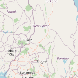
Map view of Saiwa Swamp National Park

Use this park location map to pinpoint Saiwa Swamp National Park in Kenya, understand its exact geographic position, and read its mapped placement within the surrounding landscape more clearly.

Pigeon | © OpenStreetMap contributors

Location context for Saiwa Swamp National Park

Rift Valley ProvinceTrans-Nzoia County
Park atlas

Map and compare regional protected landscapes, tracing diverse ecosystems and conservation efforts surrounding Saiwa Swamp National Park.

Continue Exploring: National Parks and Protected Areas Near Saiwa Swamp National Park
Browse a curated list of national parks and protected areas located in the vicinity of Saiwa Swamp National Park, offering opportunities to explore various conservation landscapes across western Kenya. This geographic perspective allows you to compare different protected area types, understand their regional context, and trace the distribution of key habitats such as wetlands and highlands.
National parkUganda

Mount Elgon National Park: Uganda's Transboundary Volcano and Mapped Protected Area

Explore volcanic terrain, unique cave systems, and diverse montane landscapes.

Mount Elgon National Park offers a rich tapestry of protected landscapes, centered on a dormant shield volcano straddling the Uganda-Kenya border. This park is recognized for its extraordinary botanical diversity and spectacular cave systems, such as Kitum Cave, where wildlife congregates to lick salt. The elevation gradient supports distinct vegetation zones, from dense montane forests to high-altitude heath and moorland, providing crucial habitat and watershed protection. Understanding Mount Elgon National Park through its mapped boundaries and geographic context reveals a unique protected area in East Africa.

Area
1,279 km²
Established
1968
IUCN
II
Relief
Mountain
National parkNyanza Province

Ruma National Park: Kenya National Park within Nyanza Province Geographic Atlas

Explore its protected landscape and mapped geographic boundaries.

This MoriAtlas entry details Ruma National Park, a designated national park situated in Kenya's Nyanza Province. The focus is on its identity as a protected landscape, its specific geographic footprint, and its representation within a mapped atlas of natural areas. Users can investigate the park's terrain context, its regional placement, and the precise nature of its protected boundaries, offering structured geographic insight.

Area
120 km²
Established
1983
IUCN
II
Relief
Lowland
National parkNyeri County

Aberdare National Park: Mapped Protected Landscape in Nyeri County

National Park Geography and Atlas Context

Aberdare National Park is a protected national park located within Nyeri County, Kenya. This entry offers detailed geographic information and map context, highlighting its protected boundaries and landscape characteristics. Users can explore its regional setting, understand its specific terrain features, and discover its significance as a conservation area within the Kenyan geography. Access structured data that clarifies the park's identity as a vital protected landscape.

Area
767 km²
Established
1950
IUCN
II
Relief
Mountain
National parkNakuru County

Hell's Gate National Park: National Park Atlas and Mapped Landscape Exploration

Discover Nakuru County's protected terrain and geographic context.

Explore the mapped boundaries and unique geographic identity of Hell's Gate National Park, a protected national park within Kenya's Nakuru County. This detailed atlas view focuses on the park's natural landscape and its place within the regional geography, offering structured discovery of its protected terrain and surrounding context. Understand the visual and geographic essence of this significant conservation area.

Area
68.25 km²
Established
1984
IUCN
II
Relief
Mountain
National parkKenya

Mount Kenya National Park: Mapped Volcanic Landscape & Protected Area Geography

Kenya's high-altitude Afro-alpine ecosystems and mapped park boundaries.

Mount Kenya National Park safeguards a globally significant volcanic landscape and vital water resources for Kenya. This protected area above 3,000 meters features dramatic peaks, glaciers, and distinctive Afro-alpine flora. Explore its comprehensive mapped boundaries, understand its regional geographic importance, and discover the unique ecosystems that define this exceptional national park through detailed atlas context.

Area
715 km²
Established
1949
IUCN
II
Relief
Mountain
National parkKenya

Nairobi National Park: Detailed Geographic Overview and Protected Landscape Atlas

Explore the mapped boundaries and regional context of this Kenyan national park.

Nairobi National Park represents a significant protected national park entity within Kenya. This MoriAtlas entry provides detailed insight into its geographic placement and mapped landscape characteristics. Users can delve into the park's specific location, its protected boundaries, and its contribution to the regional geography of East Africa, facilitating structured map-based exploration and understanding of this vital conservation area.

Area
117 km²
Established
1946
IUCN
II
Relief
Mixed relief
National parkRift Valley Province

Sibiloi National Park: National Park with Mapped Geographic Boundaries

Explore the protected landscape of Rift Valley Province.

Sibiloi National Park is a designated national park offering a distinct protected landscape within the broader geographic region of Rift Valley Province, Kenya. This entry focuses on its mapped boundaries and its identity as a key area for conservation, providing a structured view for geographic atlas exploration. Understand the foundational elements of Sibiloi National Park's protected status and its place within regional natural landscapes.

Area
1,570.85 km²
Established
1973
IUCN
II
Relief
Mixed relief
National parkMarsabit County

Marsabit National Park: Protected Area Identity and Geographic Setting in Kenya

Explore mapped landscape and regional park geography.

Marsabit National Park represents a critical protected area within the geographic expanse of Marsabit County, Kenya. This entry provides essential context for understanding the park's specific identity as a national park, its delineated boundaries, and its place within the natural landscape. For those interested in atlas-style exploration, this park detail offers foundational geographic information and insights into its protected status, anchoring its role in a broader discovery of Kenya's natural heritage.

Area
1,554 km²
Established
1949
Relief
Mountain
Climate
Subtropical

Common questions about visiting, size, designation, and location context for Saiwa Swamp National Park

Saiwa Swamp National Park FAQs for park facts, access, geography, and protected area context
Find quick answers about Saiwa Swamp National Park, including protected-area facts, park geography, trail and visitor context, and how the park fits into its surrounding country and regional landscape.
MoriAtlas Explorer

Continue Your Protected Areas Search Across the Global Atlas

Deepen your exploration by continuing the structured search for national parks and protected areas worldwide. Utilize the comprehensive filtering capabilities to compare different conservation landscapes and refine your understanding of global park geography. Discover more about the distribution and characteristics of protected natural areas.

Global natural geography