
Mori Atlas logo
Protected landscapeSan Bernardino National Forest

Mapping the dramatic ecological transition from chaparral foothills to high-altitude pine summits

San Bernardino National Forest: A Comprehensive Geographic Profile of a Southern California Protected Landscape

San Bernardino National Forest represents a vast expanse of federally protected mountain terrain across Southern California, encompassing over 820,000 acres. This protected landscape uniquely integrates the San Gabriel, San Bernardino, San Jacinto, and Santa Rosa mountain ranges. The region features a steep ecological gradient from dry foothills to dense conifer forests and alpine ridges, hosting seven distinct wilderness areas and prominent waterfalls. Our atlas provides a detailed look at the forest boundaries, complex geologic features, and the varied terrain that defines this critical Southern California watershed.

national forestSouthern Californiamountain landscapewilderness areasold-growth forestmixed conifer forest
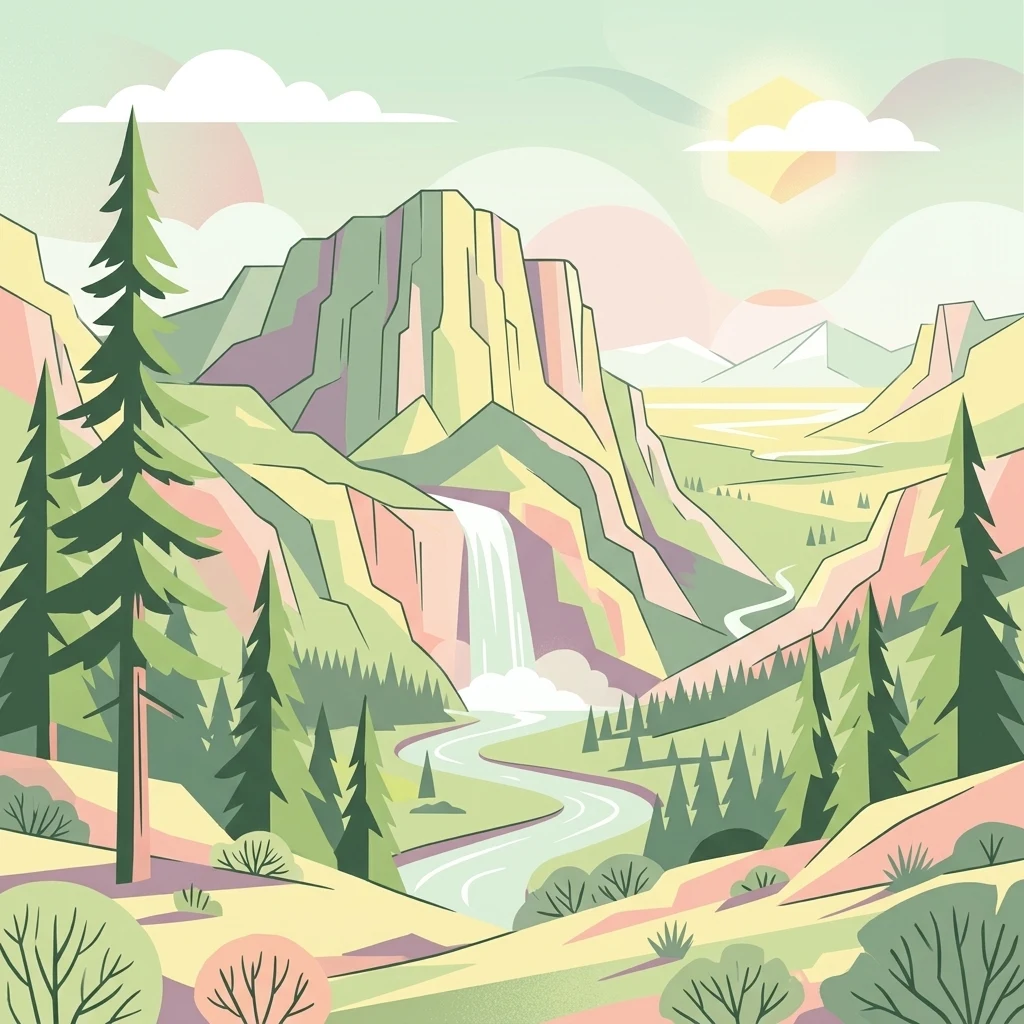
A graphic illustration featuring steep mountains, a waterfall cascading into a winding river, and surrounding evergreen pine trees in a soft, pastel color palette.

San Bernardino National Forest

Protected landscape

Park overview

Structured park overview, official facts, and landscape profile for San Bernardino National Forest

San Bernardino National Forest park facts, protected area profile, and essential visitor context

Review the core facts for San Bernardino National Forest, including designation, size, terrain, visitor scale, habitats, and operating context in one park-focused overview.

About San Bernardino National Forest

San Bernardino National Forest is a major component of Southern California's natural landscape, covering mountain terrain east and south of the Los Angeles Basin. It anchors the wild, forested skyline visible from much of inland Southern California and serves as a critical natural barrier between urbanized valleys and the Mojave and Colorado Desert regions beyond.

The forest is unusually diverse for a U.S. national forest because it spans multiple major mountain systems. In the north, it encompasses the eastern San Gabriel Mountains and the entire San Bernardino Mountains, both part of the Transverse Ranges, an east-west trending geological belt unique in North America. In the south, the forest extends into the Peninsular Ranges, covering the San Jacinto Mountains and the northern Santa Rosa Mountains, which trend southeast toward the Mexican border.

This geographic split creates a forest of distinct ecological zones. Lower elevations are dominated by chaparral, scrub oak, and pinyon-juniper woodland, while mid-elevations support oak forests and mixed conifers. At the highest elevations, dense stands of pine and fir give way to alpine environments near the summits of San Gorgonio Mountain and Mount San Jacinto. Lost Lake, a sag pond created by tectonic activity along the San Andreas Fault, lies within the forest near Cajon Pass, illustrating the dynamic geological forces that shaped the region.

Beyond its ecological value, San Bernardino National Forest is also a major recreational landscape. The forest contains seven congressionally designated wilderness areas: San Gorgonio, Cucamonga, San Jacinto, South Fork, Santa Rosa, Cahuilla Mountain, and Bighorn Mountain. These areas preserve some of the most rugged and least-developed terrain in Southern California. The forest also surrounds the James Reserve, a University of California research station used for ecological study, and contains cultural resources tied to the region's indigenous communities, including pictographs and historically important caves.

Recreationally, the forest draws visitors for hiking, camping, rock climbing, and winter sports. The Tahquitz Rock area near Idyllwild is a renowned rock climbing destination, while Big Bear Lake and surrounding communities support skiing, snowboarding, and mountain tourism. The forest offers 47 free 'Yellow Post' campsites scattered across its landscape, reflecting its role as an accessible, multi-use public forest steeped in Southern California's outdoor culture.

Quick facts and research context for San Bernardino National Forest

San Bernardino National Forest spans roughly 823,816 acres across San Bernardino and Riverside counties in Southern California, with about 677,982 acres under federal management. Established in 1907 and administered by the U.S. Forest Service, it is one of the oldest national forests in the region.

The forest stretches across the eastern San Gabriel Mountains, the San Bernardino Mountains, the San Jacinto Mountains, and the northern Santa Rosa Mountains, with elevations ranging from about 2,000 to 11,499 feet. It contains seven official wilderness areas, an estimated 87,400 acres of old-growth forest, and crosses the historic Juan Bautista de Anza National Historic Trail.

Protection and recognition

Terrestrial conservation scope and documented protected area framework

San Bernardino National Forest Protection Status and Land Designation

San Bernardino National Forest maintains a documented terrestrial protection scope and structured conservation framework. Official records outline the baseline regulatory status and administrative boundaries governing the protected landscape.

Protection details

Protection scope
Terrestrial
Transboundary protection
No
Core area
2,743.7 km²
Park context

Deeper park guide and search-rich context for San Bernardino National Forest

San Bernardino National Forest history, landscape, wildlife, and travel context

Explore San Bernardino National Forest through its history, landscape character, ecosystems, wildlife, conservation priorities, cultural context, and seasonal travel timing in a structured park guide built for atlas discovery and search intent.

Why San Bernardino National Forest stands out

San Bernardino National Forest is best known for its dramatic transition from low desert foothills to towering pine-clad summits in the span of just a few miles. The forest is defined by four distinct mountain ranges: the San Gabriel Mountains, the San Bernardino Mountains, and the San Jacinto and Santa Rosa Mountains, giving it a unique cross-range character. Within these ranges lie seven designated wilderness areas, prominent Southern California peaks, and some of the region's highest waterfalls, including Big Falls and Bonita Falls. The forest is also closely associated with mountain resort communities such as Big Bear, Fawnskin, and Idyllwild, as well as legendary rock climbing areas like Tahquitz Rock near Idyllwild.
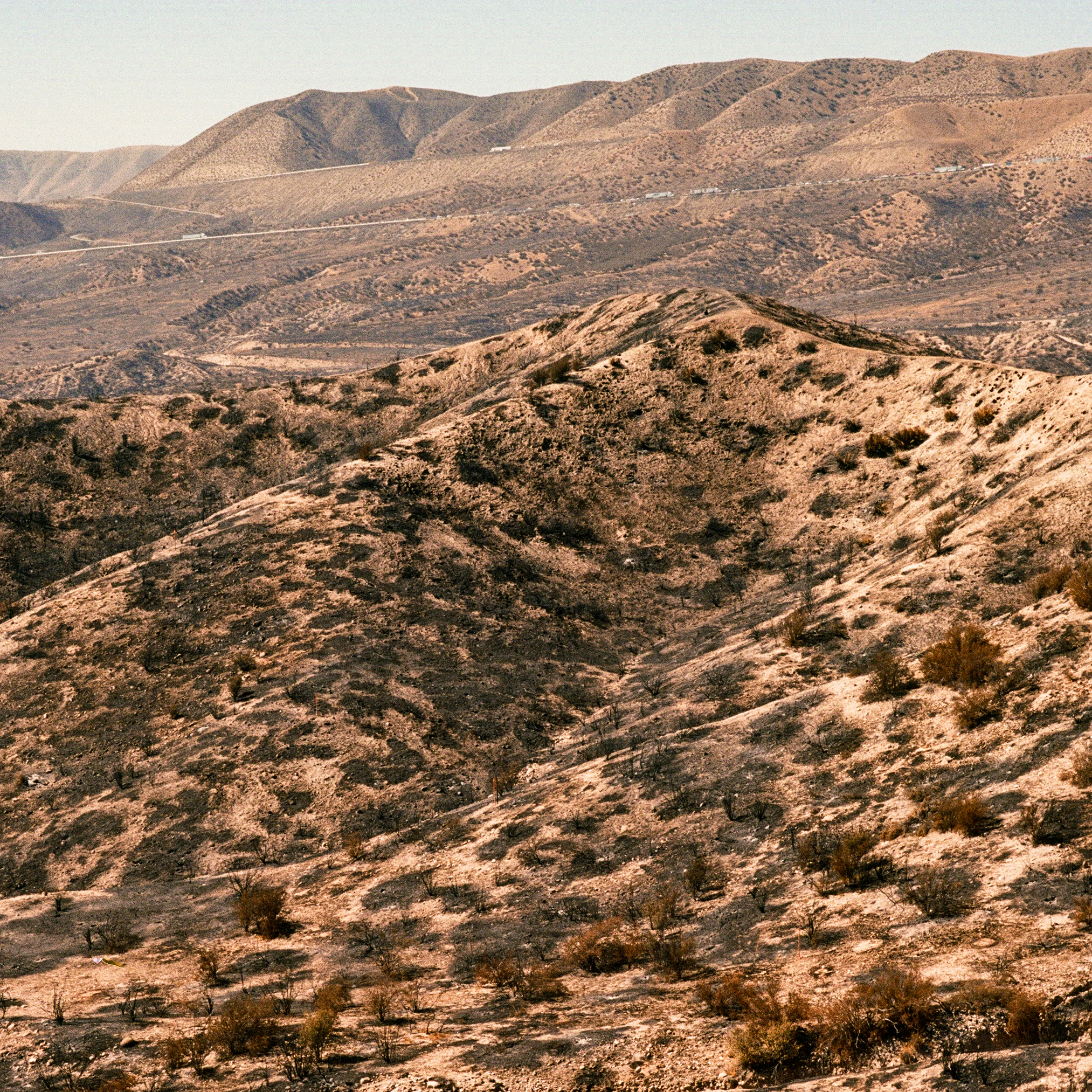
A wide, arid landscape of rolling hills and slopes showing evidence of fire damage, with blackened vegetation and exposed dry earth under a clear sky.
A view of the San Bernardino National Forest landscape following the 2016 Blue Cut Fire.

San Bernardino National Forest history and protected-area timeline

San Bernardino National Forest was established in 1907, making it one of the older national forests in the U.S. system and reflecting early federal recognition of Southern California's mountain watersheds as critical natural resources. Its creation came at a time when national forests in the western United States were being delineated to protect timber, watersheds, and unregulated lands from overuse.

Over the more than a century since, the forest's boundaries and management have been shaped by the expansion of Southern California's population and the growing demand for outdoor recreation near major metropolitan areas. Wilderness designation has been a key part of its modern identity, with seven wilderness areas now formally protected within the forest as part of the National Wilderness Preservation System.

The forest has also acquired cultural and popular significance beyond its administrative history. In 1936, it served as a filming location for the film Daniel Boone, and parts of the 1969 musical Paint Your Wagon were also shot within its terrain. More recently, the live-streamed bald eagle nest of Jackie and Shadow near Big Bear Valley, located inside the forest, has brought the area global attention. Each of these milestones reflects how the forest has functioned both as a managed natural landscape and as a meaningful cultural touchstone for Southern California.

San Bernardino National Forest landscape and geographic character

San Bernardino National Forest covers a wide swath of mountainous terrain across Southern California, organized geographically into a northern division that includes the San Gabriel and San Bernardino Mountains, and a southern division that includes the San Jacinto and Santa Rosa Mountains.

The northern portion stretches roughly 57 miles east to west at its widest, extending east of Big Bear City and west toward Mount San Antonio and the community of Wrightwood. Its landscape is defined by steep, pine-clad slopes, deep canyons, and the highest peaks of the Transverse Ranges. The southern portion spans about 27 miles north to south and 30 miles east to west, a more compact but ecologically rich region that includes Toro Peak near its southern extent and is bordered by the Santa Rosa and Morongo Indian Reservations.

Elevations range from roughly 2,000 feet along the lower foothills to 11,499 feet near the highest summits, giving the forest an unusually steep ecological gradient. The dramatic relief produces some of Southern California's most striking scenery, from broad valley floors to rugged alpine ridges. Big Falls and Bonita Falls, two of the tallest waterfalls in Southern California, lie within the forest, along with Lost Lake, a sag pond that formed from tectonic activity along the San Andreas Fault near Cajon Pass.

San Bernardino National Forest ecosystems, habitats, and plant life

San Bernardino National Forest hosts an exceptionally diverse range of vegetation zones due to its wide elevation gradient. Lower slopes are covered in chaparral and scrub oak communities that transition into pinyon and juniper woodlands, while mid-elevations support oak forests and dense mixed conifer stands. The highest elevations are dominated by pine and fir forests, including some of Southern California's most extensive montane conifer landscapes.

The forest contains an estimated 87,400 acres of old-growth forest, making it an important stronghold of mature, undisturbed woodland in an otherwise heavily developed region. The most common old-growth forest types are Sierra Nevada mixed conifer, white fir, Jeffrey pine, and lodgepole pine forests, each adapted to different elevation and moisture conditions.

These habitat zones support a wide variety of plant species, including ponderosa pine, Jeffrey pine, sugar pine, Coulter pine, lodgepole pine, single-leaf pinyon, knobcone pine, white fir, bigcone Douglas-fir, incense cedar, western juniper, canyon live oak, California black oak, and Pacific dogwood. This botanical richness contributes to the forest's ecological complexity and its reputation as a transition zone between montane and alpine communities in Southern California.

San Bernardino National Forest wildlife and species highlights

San Bernardino National Forest supports a diverse mix of wildlife typical of Southern California's mountain ecosystems, ranging from large mammals such as black bear and mule deer to montane bird species adapted to pine and fir forests. The forest's elevation gradient and habitat diversity create niches for species that rely on chaparral, oak woodlands, and conifer forests across different life stages and seasons.

Among the most widely recognized wildlife residents is the bald eagle, exemplified by the famous nesting pair Jackie and Shadow, whose nest in the Big Bear Valley area of the forest has become a globally watched livestream through Friends of Big Bear Valley. This pair has significantly raised public awareness of the forest as habitat for large raptors and other sensitive species.

The forest's wilderness areas, old-growth stands, and rugged canyon terrain provide refuge for numerous species that would otherwise struggle in heavily urbanized Southern California. These protected zones play an important role in maintaining habitat connectivity, supporting migratory and resident bird populations, and preserving the ecological conditions needed for species recovery in the region.

San Bernardino National Forest conservation status and protection priorities

San Bernardino National Forest plays a critical conservation role in a region where wild landscapes are increasingly surrounded by dense urban development. Its more than 820,000 acres of protected terrain safeguard watersheds, air quality, and habitat for a broad spectrum of native species, while also serving as a natural buffer between populated valleys and arid lands to the east.

The forest's seven designated wilderness areas, San Gorgonio, Cucamonga, San Jacinto, South Fork, Santa Rosa, Cahuilla Mountain, and Bighorn Mountain, form the core of its formal conservation protection. Several of these extend into neighboring Angeles National Forest or Bureau of Land Management holdings, creating larger contiguous blocks of preserved habitat. Old-growth forest, totaling an estimated 87,400 acres, provides especially important ecological value, supporting sensitive species, storing carbon, and maintaining watershed function.

The forest also hosts research infrastructure, including the University of California's James Reserve, which contributes to long-term ecological monitoring and biodiversity studies. Combined with protected wilderness designations, this scientific presence reinforces the forest's role as both a working landscape and a refuge for Southern California's natural heritage.

San Bernardino National Forest cultural meaning and human context

San Bernardino National Forest is closely tied to the cultural and historical identity of Southern California's mountain regions. Its landscape overlays areas long associated with indigenous communities, including the Cahuilla and Serrano peoples, whose presence is reflected today in surrounding reservations such as the Morongo and Santa Rosa Indian Reservations. The forest contains culturally important sites, including historically significant caves and pictographs, illustrating the long human relationship with these mountains.

The forest has also become part of regional recreational culture, anchoring popular mountain communities such as Big Bear, Fawnskin, and Idyllwild. Identified scenic locations, including Tahquitz Rock, have developed reputations among climbers and outdoor enthusiasts that extend beyond California. The presence of the Juan Bautista de Anza National Historic Trail through the forest connects it to the broader Spanish colonial history of the American Southwest, reinforcing the landscape's multilayered cultural significance.

Top sights and standout views in San Bernardino National Forest

San Bernardino National Forest is distinguished in Southern California by its four-mountain geographic structure, an unusual feature among U.S. national forests that combines ranges from both the Transverse and Peninsular systems. Its seven wilderness areas form one of the densest clusters of formally protected wild landscapes in the region, anchored by iconic peaks such as San Gorgonio Mountain and Mount San Jacinto.

The forest also stands out for its roughly 87,400 acres of old-growth forest, including Sierra Nevada mixed conifer, white fir, Jeffrey pine, and lodgepole pine communities that are rare in heavily populated Southern California. Combined with famous hanging waterfalls, the Anza National Historic Trail, renowned climbing at Tahquitz Rock, and globally watched bald eagle nest, the forest offers a uniquely layered blend of ecological, recreational, and cultural value.

Best time to visit San Bernardino National Forest

San Bernardino National Forest offers distinct seasonal experiences shaped by its elevation range. Late spring through early autumn is generally the most versatile period for visiting, when lower-elevation trails are accessible, waterfalls are typically flowing, and high-country roads are mostly open. Summer brings warm conditions in the valleys but cooler temperatures at higher elevations, making the mountains a popular escape from the heat of the broader Southern California lowlands.

Winter transforms the higher portions of the forest, especially around Big Bear and the San Bernardino Mountains, into a snowy landscape suited to skiing, snowboarding, and winter scenery. Visitors should be aware that weather can vary dramatically between lower and higher elevations. The transitional seasons of spring and autumn are often especially rewarding for wildflowers, fall color in the aspens and oaks, and fewer crowds than peak summer or ski weekends.
Monthly climate preview

Long-term temperature ranges and monthly precipitation averages for San Bernardino National Forest

San Bernardino National Forest Climate Normals and Annual Weather Patterns

San Bernardino National Forest records documented average monthly temperatures and precipitation rates spanning a multi-year baseline period at a sampled elevation point. Examining the complete monthly climate profile reveals detailed temperature shifts and precipitation fluctuations across the entire calendar year.
Annual mean16 °C
8 °C26 °C
Jan
Feb
Mar11°
Apr14°
May18°
Jun22°
Jul26°
Aug26°
Sep23°
Oct18°
Nov12°
Dec
Warmest month
August

26.3 °C

Coolest month
December

7.9 °C

Wettest month
February

1.6 mm/day

Driest month
June

0.1 mm/day

Park location guide

Geography guide, regional context, and park location map for San Bernardino National Forest

San Bernardino National Forest park geography, regions, and map view in United States of America

Understand where San Bernardino National Forest sits in United States of America through a broader geographic reading of the surrounding landscape, nearby location context, and its mapped position within the national park landscape.

How San Bernardino National Forest fits into United States of America

The United States of America is a federal presidential republic and one of the world's largest countries by area and population. It consists of 50 states across a vast territory spanning multiple time zones, with its capital in Washington, D.C. and largest city in New York City. The nation has a diverse economy, influential political system, and significant cultural and military presence globally.

Wider geography shaping San Bernardino National Forest in United States of America

The United States occupies a vast territory in North America, bordered by Canada to the north and Mexico to the south. The 48 contiguous states stretch from the Atlantic to the Pacific Ocean, while Alaska occupies the northwestern region and Hawaii is an archipelago in the Pacific. The country encompasses diverse terrain including the Rocky Mountains, Appalachian Mountains, Great Plains, and extensive river systems.

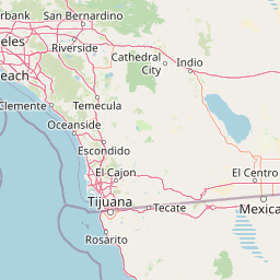
Map view of San Bernardino National Forest

Use this park location map to pinpoint San Bernardino National Forest in United States of America, understand its exact geographic position, and read its mapped placement within the surrounding landscape more clearly.

Pigeon | © OpenStreetMap contributors

Location context for San Bernardino National Forest

California
Recorded earthquake history

Examine Historical Earthquake Records for San Bernardino National Forest

Review documented seismic events associated with the diverse mountain ranges of San Bernardino National Forest. MoriAtlas provides this historical catalogue to help users analyze regional patterns based on recorded magnitude, depth, and epicentre proximity within the surrounding Southern California landscape.

San Bernardino National Forest Earthquake History

Catalogued events

3,626 events

Strongest magnitude

Magnitude 7.3

Most recent event

Sep 2, 2026

This history includes earthquakes recorded inside the park or within 50 km of its borders

Visual exploration of protected terrain, forest habitats, and mountain scenery

San Bernardino National Forest Photos and Mountain Landscapes

Examine detailed photos of San Bernardino National Forest to understand its steep ecological gradient and diverse mountain terrain. Visual records capture the transition from dry chaparral foothills to towering alpine summits and dense conifer forests.

A wide, arid landscape of rolling hills and slopes showing evidence of fire damage, with blackened vegetation and exposed dry earth under a clear sky.

A view looking up at tall, mature pine trees in a coniferous forest area, with a small wooden structure and fence visible in the foreground.

Park atlas

Compare regional mountain ranges and adjacent protected natural areas

Other Parks Near San Bernardino National Forest and Protected Landscapes

Browse nearby national parks and protected areas sharing the rugged mountainous geography of inland Southern California. Compare adjacent wilderness terrain and regional conservation landscapes to expand your understanding of local ecosystems.
A soft, painterly watercolor illustration depicting layered green mountain ridges and rolling foothills under a bright, open sky.
Protected landscapeCalifornia
Park boundaries overlap#1 closest

West

Angeles National Forest: Mapped Protected Landscapes and Geographic Terrain in California

Mountain wilderness and Mediterranean watershed geography

Spanning the San Gabriel and Sierra Pelona ranges, Angeles National Forest serves as a dramatic ecological transition zone. This analysis of its protected landscape focuses on the interaction between steep canyons, high peaks, and the distinct chaparral and conifer zones that shape California geography.

Area
2,652.26 km²
Established
1908
Relief
Mountain
Climate
Mediterranean
National parkCalifornia
19 km away#2 closest

East

Joshua Tree National Park: Mapped Protected Landscape and Regional Geography in California

Explore unique park boundaries and natural terrain across Southern California.

Joshua Tree National Park is a vital protected area in California, known for its distinctive natural landscape and geographic setting. This entry provides detailed information on the park's mapped boundaries and the unique terrain it encompasses, serving as a key point for atlas exploration of protected lands. Understand the regional geography and the specific character of this significant national park.

Area
3,217.9 km²
Established
1994
IUCN
II
Visitors
3.1M annual
A watercolor illustration of rolling green hills, a small shoreline, and patches of grass against a white background.
Protected landscapeCalifornia
63 km away#3 closest

West

Santa Monica Mountains National Recreation Area: Protected Landscape and Regional Geography

Exploring the ecological and cultural tapestry of Southern California's coastal mountains.

Santa Monica Mountains National Recreation Area comprises a complex array of parks and preserves that protect the unique Mediterranean climate of Southern California. The terrain showcases rugged ridgelines, deeply carved canyons, and vital coastal habitats. As a significant urban protected area, it offers an essential look at how biodiversity, human history, and regional geography coexist within one of the most populated zones in the United States.

Area
638 km²
Established
1978
IUCN
V
Visitors
795.2K annual
Wildlife reserveCalifornia
74 km away#4 closest

Southeast

Fish Creek Mountains Wilderness: Mapping the Rugged Colorado Desert Plateau in California

Exploring desert ridges and ancient shoreline remnants

Fish Creek Mountains Wilderness offers a study in desert geomorphology, rising as an abrupt plateau above the surrounding basin. This Bureau of Land Management protected area contains intricate erosional landforms, including twisting canyons and natural rock tanks sustained by limestone outcrops. These features create a critical desert wildlife habitat that maintains moisture long after seasonal storms, offering a quiet, undisturbed perspective on the broader Imperial County landscape.

Area
86.7 km²
Established
1994
IUCN
Ib
Relief
Mountain
Watercolor painting of a mountain landscape with forested foothills and a valley in the foreground.
Protected landscapeCalifornia
101 km away#5 closest

West

Los Padres National Forest: Geography and Protected Landscape Map of Central California

Extensive wilderness corridors and high mountain ridges

Spanning from the Big Sur coastline to the interior ranges of the Santa Lucia and San Rafael mountains, Los Padres National Forest represents a significant protected area in California. The region contains deep gorges, forest-covered canyons, and high-altitude pine ridges that provide essential habitat and support major river headwaters.

Area
7,700 km²
Established
1936
Relief
Mountain
Climate
Mediterranean
A watercolor illustration showing a soft-focused desert landscape with gentle rolling hills, sparse desert vegetation, and muted earthy tones.
Wildlife reserveKern County
122 km away#6 closest

Northwest

El Paso Mountains Wilderness: Geological Atlas and Protected Landscape Overview

Mojave Desert geography within Kern County, California

Explore the volcanic structure of El Paso Mountains Wilderness, a desert landscape dominated by Black Mountain, red buttes, and narrow canyons. This atlas entry details the protected boundary and geological features of this Mojave Desert wildlife reserve, highlighting the intersection of volcanic badlands and ancient archaeological sites.

Area
96.2 km²
Established
1994
IUCN
Ib
Relief
Mountain
Watercolor painting of a panoramic mountain landscape with stylized pine trees and soft green meadows.
Protected landscapeCalifornia
128 km away#7 closest

Northwest

Sequoia National Forest: Protected Sierra Nevada Geography and Mountain Terrain

A vast protected landscape spanning 1.1 million acres in California

Spanning Tulare, Kern, and Fresno counties, Sequoia National Forest preserves iconic giant sequoia groves across multiple river watersheds. The terrain features vertical relief exceeding 11,000 feet, showcasing a range of ecosystems from chaparral slopes and coniferous forests to glacial cirques and granite spires located within the southern Sierra Nevada range.

Area
4,829.17 km²
Established
1908
Relief
Mountain
Climate
Mediterranean
Wildlife reserveKern County
132 km away#8 closest

Northwest

Kiavah Wilderness: Geographic Overview of the Scodie Mountains Plateau

Protected desert wilderness in Kern County, California

Kiavah Wilderness provides a vital protected landscape in Kern County, defined by the Scodie Mountains and a dramatic escarpment above the Mojave Desert floor. Known for its rare pinyon-juniper woodlands and seasonal springs, this wilderness area preserves the complex geography linking the southern Sierra Nevada to the broader Mojave basin.

Area
357.3 km²
Established
1994
IUCN
Ib
Relief
Mountain

Common questions about visiting, size, designation, and location context for San Bernardino National Forest

San Bernardino National Forest FAQs for park facts, access, geography, and protected area context

Find quick answers about San Bernardino National Forest, including protected-area facts, park geography, trail and visitor context, and how the park fits into its surrounding country and regional landscape.
MoriAtlas Explorer

Continue Your Protected Areas Search Across the Global Atlas

Deepen your exploration by continuing the structured search for national parks and protected areas worldwide. Utilize the comprehensive filtering capabilities to compare different conservation landscapes and refine your understanding of global park geography. Discover more about the distribution and characteristics of protected natural areas.

Global natural geography