Mori Atlas logo
Wildlife reserveFish Creek Mountains Wilderness

Examining the complex erosional terrain, jagged ridges, and limestone outcrops of this unique wilderness.

Fish Creek Mountains Wilderness: A Rugged Desert Plateau and Protected Landscape in California

Fish Creek Mountains Wilderness represents a distinctive plateau-like massif within the Colorado Desert of southeastern California. This protected area features a complex interior of twisting canyons, jagged ridges, and sheltered valleys carved by weathering and flash floods. Beyond its rugged topography, the region preserves a segment of the ancient Lake Cahuilla shoreline, providing a clear link to the geological history of the Salton Trough. As an undisturbed desert environment, the area stands in stark contrast to the intensely managed agricultural landscapes of the nearby Imperial Valley.

desert wildernessColorado Desertplateau landscapelimestone terrainancient lake shorelineBureau of Land Management

Fish Creek Mountains Wilderness

Wildlife reserve

Park overview

Structured park overview, official facts, and landscape profile for Fish Creek Mountains Wilderness

Fish Creek Mountains Wilderness park facts, protected area profile, and essential visitor context

Review the core facts for Fish Creek Mountains Wilderness, including designation, size, terrain, visitor scale, habitats, and operating context in one park-focused overview.

About Fish Creek Mountains Wilderness

Fish Creek Mountains Wilderness protects a section of the Fish Creek Mountains in the northern Colorado Desert of southeastern California. Although located within a relatively short distance of the agricultural Imperial Valley, the wilderness preserves a rugged, largely uninhabited landscape that feels far removed from human development. It lies southeast of the better-known Vallecito Mountains and south of Anza-Borrego Desert State Park, placing it in a transition zone between several major desert and mountain landscapes of southern California and northern Baja.

From a distance the Fish Creek Mountains appear as a solid, plateau-like wall rising sharply from the desert basin, with few obviously commanding peaks. Up close, however, the range reveals a highly dissected terrain of jagged ridges, deep chutes, twisting canyons, and small hidden valleys. This combination of apparent uniformity from afar and intricate topography within is one of the defining visual characteristics of the wilderness, giving it a layered sense of scale and discovery for anyone traveling through it on foot.

The wilderness is also notable for its position along the northern boundary of the Carrizo Impact Area, a military-managed zone that is closed to the public. The limited surrounding access has helped keep the Fish Creek Mountains relatively undisturbed compared with other desert ranges closer to population centers. Together with its formally designated wilderness status, this geographic setting makes the area an important refuge for desert ecosystems in a region where most lowland landscapes have been heavily altered for agriculture or energy development.

Quick facts and research context for Fish Creek Mountains Wilderness

Fish Creek Mountains Wilderness is a federally designated wilderness area in Imperial County, California, situated in the Colorado Desert and administered by the Bureau of Land Management.

The wilderness covers roughly 21,425 acres and was formally established in 1994 under the U.S. wilderness system. It sits at the northern edge of the Carrizo Impact Area, a military zone closed to the public, which helps preserve the wilderness in a relatively undisturbed state.

The region carries strong geological and hydrological history, including limestone formations that have shaped local drainage patterns and a preserved shoreline segment of the ancient Lake Cahuilla, which once filled the Imperial and Coachella Valleys before receding centuries ago.

Protection and recognition

Examine documented terrestrial conservation frameworks and administrative scope.

Fish Creek Mountains Wilderness Protection Status and Recognition Data

Terrestrial protection status and management parameters define the conservation framework for Fish Creek Mountains Wilderness. Available administrative records outline official designation history and international recognition metrics.

Protection details

Protection scope
Terrestrial
Transboundary protection
No
Park context

Deeper park guide and search-rich context for Fish Creek Mountains Wilderness

Fish Creek Mountains Wilderness history, landscape, wildlife, and travel context

Explore Fish Creek Mountains Wilderness through its history, landscape character, ecosystems, wildlife, conservation priorities, cultural context, and seasonal travel timing in a structured park guide built for atlas discovery and search intent.

Why Fish Creek Mountains Wilderness stands out

The wilderness is best known for its dramatic plateau-like appearance above the desert basin, with rugged ridges, twisting canyons, and small valleys that only become apparent on close exploration. Its limestone outcrops, which have resisted erosion, support natural water-holding chutes that sustain desert wildlife long after seasonal storms pass. Another defining feature is the visible remnant of the ancient Lake Cahuilla shoreline, which ties the area to the broader geological and ecological history of the Salton Trough region. Combined with its position in the Colorado Desert and proximity to the Carrizo Impact Area, the wilderness offers a quiet, rugged counterpart to the more heavily visited desert landscapes of southeastern California.
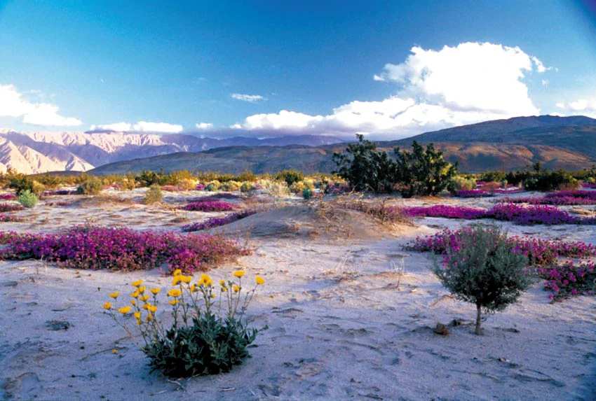
Wide shot of a desert landscape during spring with patches of pink and yellow wildflowers in the foreground, sparse desert shrubs, and distant mountain ranges under a clear blue sky with some clouds.
A springtime view of the desert floor in the Fish Creek Mountains Wilderness, featuring blooming wildflowers and rugged mountains in the distance.

Fish Creek Mountains Wilderness history and protected-area timeline

Fish Creek Mountains Wilderness was formally designated in 1994 as part of the United States wilderness preservation system. Its establishment reflected a broader recognition of the Fish Creek Mountains and surrounding desert landscapes as ecologically and geologically significant, particularly within the context of southern California's Colorado Desert, where lowland areas have been extensively converted to other uses.

The Carrizo Impact Area, within which the wilderness sits in part, has a separate institutional history tied to military use of the desert for training and testing. The closure of that area to the public has, over time, contributed to the relative preservation of the surrounding landscape, including the segments that now form the wilderness.

Beyond modern designations, the region carries deep natural history tied to ancient Lake Cahuilla, a large freshwater body that historically filled the Imperial and Coachella Valleys before receding roughly 500 years ago. The preserved shoreline visible within the wilderness offers a tangible connection to that earlier hydrological era, long predating any contemporary protected-area boundary.

Fish Creek Mountains Wilderness landscape and geographic character

The Fish Creek Mountains present one of the most distinctive massifs in the Colorado Desert: a high, plateau-like block that rises abruptly from the desert basin like a wall, then fractures, on closer inspection, into a complex of jagged ridges, twisting canyons, and small sheltered valleys. From a distance the range appears deceptively uniform, with few dramatic peak silhouettes. Within its interior it becomes a deeply textured landscape of erosional features shaped by flash floods and centuries of weathering.

A defining element of the terrain is its limestone outcrops, which have resisted erosion more effectively than surrounding rock. These outcrops channel water from intense desert cloudbursts into narrow chutes and pools at their base. Because the chutes are shielded from direct sunlight, water persists at these sites long after storms have passed, leaving seasonal tinajas, or natural rock tanks, scattered through the range.

In addition to its rocky terrain, the wilderness contains a preserved segment of the ancient Lake Cahuilla shoreline. This subtle but traceable feature marks a former water level far above the modern desert floor and connects the Fish Creek Mountains to the larger geological story of the Salton Trough and the present-day Imperial and Coachella Valleys. South of the range lies Anza-Borrego Desert State Park, and west lies the flat expanse of the Imperial Valley, emphasizing how sharply the mountains rise above neighboring landscapes.

Fish Creek Mountains Wilderness ecosystems, habitats, and plant life

Vegetation in Fish Creek Mountains Wilderness reflects the broader character of the Colorado Desert, with desert scrub and drought-adapted plants dominating the exposed slopes and lower basins. Higher and more sheltered areas support denser stands of hardy desert vegetation, while the bottoms of canyons and other sheltered environments retain enough moisture to host richer plant life than the surrounding open desert.

Because of the limestone-controlled water catchments described above, certain microsites within the wilderness retain water far longer than typical desert settings. These wetter pockets create localized habitat islands that contrast with the otherwise arid terrain, supporting a more diverse community of plants and animals than the surrounding desert flats.

The wilderness falls within the broad ecosystem of the Colorado Desert section of the Sonoran Desert ecoregion, a region renowned for its springtime wildflower displays in favorable years. Although the Fish Creek Mountains themselves are not the most heavily publicized wildflower sites, they share the regional climate patterns, soil types, and elevation gradients that drive the periodic bloom events across southeastern California.

Fish Creek Mountains Wilderness wildlife and species highlights

Wildlife in Fish Creek Mountains Wilderness is shaped strongly by the availability of water in an otherwise arid landscape. The natural rock tanks formed at the bases of limestone chutes serve as critical seasonal and sometimes year-round water sources for desert animals, functioning as wildlife oases within a broader matrix of dry terrain.

A wide range of typical Colorado Desert species can be expected in the area, including desert-adapted mammals, reptiles, and birds that take advantage of both the rugged rocky habitat for shelter and the scattered water sources for survival. The remote, undisturbed character of the mountains, reinforced by the proximity of the off-limits Carrizo Impact Area, helps provide relatively continuous habitat across a sizable block of land.

The canyons, ridgelines, and small valleys of the range also offer varied hunting and nesting niches, allowing species with different habitat preferences to coexist across short distances. For the visitor, this means that even short walks into the range can reveal very different ecological conditions, from hot, exposed ridges to cooler, shaded canyon bottoms.

Fish Creek Mountains Wilderness conservation status and protection priorities

Conservation significance in Fish Creek Mountains Wilderness stems from its formal wilderness designation, its management by the Bureau of Land Management, and its integration into the U.S. National Wilderness Preservation System. This designation places a long-term federal framework around the protection of its natural character, restricting development and ensuring that the area remains substantially undisturbed.

The wilderness is especially important in a regional context. Much of the surrounding lowland in the Colorado Desert region has been transformed by irrigated agriculture, geothermal development, and urban expansion, particularly in the Imperial Valley. By contrast, the Fish Creek Mountains remain a relatively intact block of rugged desert terrain in an otherwise heavily altered region.

The proximity of the Carrizo Impact Area, although closed to the public, has the unintended conservation benefit of reducing access pressures on the adjacent wilderness. Together, the formal designation, the surrounding restrictions, and the persistence of natural water catchments make the wilderness a valuable refuge for Colorado Desert ecosystems, supporting ecological processes that operate across larger and more continuous landscapes than is typical in the modern southeastern California desert.

Top sights and standout views in Fish Creek Mountains Wilderness

The wilderness's most compelling features include its plateau-like silhouette rising abruptly from the desert basin, the intricate network of jagged ridges and twisting canyons hidden within that silhouette, and the persistent natural water catchments formed by limestone outcrops. These rock tanks give the range a distinctive ecological rhythm, supporting wildlife at sites that retain moisture long after seasonal storms.

Equally notable is the preserved shoreline of ancient Lake Cahuilla, a reminder that the dry basin of the modern Imperial and Coachella Valleys was once filled by a vast freshwater lake. Set against the backdrop of the Carrizo Impact Area and its access restrictions, the wilderness offers an unusually quiet, undeveloped desert experience in a region where most lowlands have been reshaped by human activity.

Best time to visit Fish Creek Mountains Wilderness

The cooler months from late autumn through early spring are generally the most comfortable period for visiting Fish Creek Mountains Wilderness, when daytime desert temperatures are milder and conditions for hiking and exploration are more forgiving. Winter and early spring are also the seasons most likely to bring the region's striking wildflower displays in years of sufficient rainfall, including species such as the Mexican gold poppy noted in the surrounding area.

Summer visits are possible but demanding, as the Colorado Desert can experience extreme heat. Travelers choosing that season typically plan for very early starts, careful hydration, and an awareness of the limited shade and intense sun exposure. Because camping is limited to 14 days in any one location and requires relocation afterward, visitors planning longer stays should plan movements carefully across the surrounding public lands.

Monthly climate preview

Long-term representative monthly temperature and precipitation data for California protected terrain

Fish Creek Mountains Wilderness Climate Normals and Annual Temperature Patterns

Historical climate records for Fish Creek Mountains Wilderness show a measured annual progression of average monthly temperatures and precipitation rates from a representative coordinate. Detailed monthly data profiles reveal complete long-term temperature ranges and precipitation metrics across the protected landscape.
Annual mean20 °C
11 °C30 °C
Jan11°
Feb12°
Mar15°
Apr17°
May21°
Jun26°
Jul30°
Aug30°
Sep27°
Oct21°
Nov15°
Dec11°
Warmest month
August

30.5 °C

Coolest month
December

10.6 °C

Wettest month
February

2.1 mm/day

Driest month
June

0.1 mm/day

Park location guide

Geography guide, regional context, and park location map for Fish Creek Mountains Wilderness

Fish Creek Mountains Wilderness park geography, regions, and map view in United States of America

Understand where Fish Creek Mountains Wilderness sits in United States of America through a broader geographic reading of the surrounding landscape, nearby location context, and its mapped position within the national park landscape.

How Fish Creek Mountains Wilderness fits into United States of America

The United States of America is a federal presidential republic and one of the world's largest countries by area and population. It consists of 50 states across a vast territory spanning multiple time zones, with its capital in Washington, D.C. and largest city in New York City. The nation has a diverse economy, influential political system, and significant cultural and military presence globally.

Wider geography shaping Fish Creek Mountains Wilderness in United States of America

The United States occupies a vast territory in North America, bordered by Canada to the north and Mexico to the south. The 48 contiguous states stretch from the Atlantic to the Pacific Ocean, while Alaska occupies the northwestern region and Hawaii is an archipelago in the Pacific. The country encompasses diverse terrain including the Rocky Mountains, Appalachian Mountains, Great Plains, and extensive river systems.

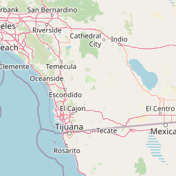
Map view of Fish Creek Mountains Wilderness

Use this park location map to pinpoint Fish Creek Mountains Wilderness in United States of America, understand its exact geographic position, and read its mapped placement within the surrounding landscape more clearly.

Pigeon | © OpenStreetMap contributors

Location context for Fish Creek Mountains Wilderness

California
Recorded earthquake history

Examine the Recorded Earthquake History of Fish Creek Mountains Wilderness

Trace the historical seismic record associated with the landscape of Fish Creek Mountains Wilderness. This catalogue provides a structured view of past earthquake activity recorded in the surrounding Colorado Desert, helping to visualize the regional geological context of this protected wilderness area.

Fish Creek Mountains Wilderness Earthquake History

Catalogued events

2,550 events

Strongest magnitude

Magnitude 6.6

Most recent event

Aug 25, 2026

This history includes earthquakes recorded inside the park or within 50 km of its borders

Visual reference guide to plateau terrain, limestone outcrops, and desert habitats.

Fish Creek Mountains Wilderness Photos and Landscape Scenery

Visual documentation captures the dramatic desert massifs, twisted canyons, and ancient lake shorelines defining Fish Creek Mountains Wilderness. Examining these protected landscapes reveals the rugged terrain, limestone rock tanks, and remote character of the southern California desert ecosystem.

Wide shot of a desert landscape during spring with patches of pink and yellow wildflowers in the foreground, sparse desert shrubs, and distant mountain ranges under a clear blue sky with some clouds.

Park atlas

Compare adjacent desert landscapes and regional protected areas in southeastern California

Other Parks Near Fish Creek Mountains Wilderness and Surrounding Desert Protected Areas

Browse nearby national parks and protected lands to examine shared desert terrain, rugged canyons, and regional conservation geography. Continuing the exploration from Fish Creek Mountains Wilderness provides a broader perspective on the natural history of the Colorado Desert.
National parkCalifornia
73 km away#1 closest

North

Joshua Tree National Park: Mapped Protected Landscape and Regional Geography in California

Explore unique park boundaries and natural terrain across Southern California.

Joshua Tree National Park is a vital protected area in California, known for its distinctive natural landscape and geographic setting. This entry provides detailed information on the park's mapped boundaries and the unique terrain it encompasses, serving as a key point for atlas exploration of protected lands. Understand the regional geography and the specific character of this significant national park.

Area
3,217.9 km²
Established
1994
IUCN
II
Visitors
3.1M annual
Watercolor painting of a mountain landscape with rolling green hills and small evergreen trees, with soft purple mountain silhouettes in the distance.
Protected landscapeCalifornia
74 km away#2 closest

Northwest

San Bernardino National Forest: Geography and Protected Landscape Atlas

Transverse and Peninsular mountain ranges in California

Spanning over 820,000 acres, San Bernardino National Forest offers a look at one of Southern California's most significant protected landscapes. The forest features seven wilderness areas and a dramatic range of elevation, moving from arid chaparral to old-growth mixed conifer forests. Our geographic mapping traces the unique structure of four intersecting mountain ranges, detailing the terrain from deep canyons to high alpine peaks.

Area
3,333.87 km²
Established
1907
Relief
Mountain
Climate
Mediterranean
National parkEnsenada Municipality
About 98 km away#3 closest

South

Constitution 1857 National Park National Park: Mapped Protected Landscape Discovery

Geographic context and park boundaries for Ensenada Municipality.

Delve into the protected landscape of Constitution 1857 National Park, a key national park entity located in the Ensenada Municipality. This resource highlights the park's distinct geographic features and mapped protected area, crucial for atlas exploration and understanding the regional natural terrain. Gain structured insight into the park's identity and its role within the wider geographic context.

Area
50.09 km²
Established
1962
IUCN
II
Relief
Mountain
Wildlife reserveCalifornia
About 110 km away#4 closest

East

Indian Pass Wilderness: Protected Sonoran Desert Geography and Terrain Mapping

Analyzing desert mountain slopes and riparian corridors in California

Indian Pass Wilderness represents a key protected-area unit where the arid Chocolate Mountains descend into the Lower Colorado River Valley. The area is defined by its dramatic drainage patterns, including Julian Wash, and its role as a transition zone between desert upland and riparian edge, serving as a critical study for understanding southwestern desert geography and protected landscape boundaries.

Area
131.19 km²
Established
1994
IUCN
Ib
Relief
Mountain
Wildlife reserveCalifornia
124 km away#5 closest

East

Little Picacho Wilderness: Exploring the Protected Volcanic Terrain and Desert Geography

A rugged wilderness reserve in southeastern California

Little Picacho Wilderness is a protected desert landscape located along the lower Colorado River corridor. The area is defined by dramatic volcanic ridges, Picacho Peak, and extensive arid desert washes. This wildlife reserve serves as an important refuge for desert bighorn sheep, desert tortoises, and free-roaming wild horse herds, offering a clear window into the rugged geography of the Sonoran Desert.

Area
154.65 km²
Established
1994
IUCN
Ib
Relief
Mountain
Watercolor painting showing a soft landscape with rolling hills in the background and a grassy plain with sparse trees and water in the foreground.
Wildlife reserveUnited States of America
About 175 km away#6 closest

Northeast

Riverside Mountains Wilderness: Mapping the Desert Peaks and Protected Landscapes of California

A rugged desert wildlife reserve within the Lower Colorado River Valley

Riverside Mountains Wilderness features a tightly woven mosaic of dry drainages, rocky slopes, and sheltered canyon pockets. Situated in Riverside County, California, this protected area showcases a striking transition between steep mountain crags and open desert flats, providing a meaningful look at the Sonoran and Colorado Desert ecosystems along the Colorado River corridor.

Area
97.14 km²
Established
1994
Relief
Mountain
Climate
Arid
A soft, painterly watercolor illustration depicting layered green mountain ridges and rolling foothills under a bright, open sky.
Protected landscapeCalifornia
193 km away#7 closest

Northwest

Angeles National Forest: Mapped Protected Landscapes and Geographic Terrain in California

Mountain wilderness and Mediterranean watershed geography

Spanning the San Gabriel and Sierra Pelona ranges, Angeles National Forest serves as a dramatic ecological transition zone. This analysis of its protected landscape focuses on the interaction between steep canyons, high peaks, and the distinct chaparral and conifer zones that shape California geography.

Area
2,652.26 km²
Established
1908
Relief
Mountain
Climate
Mediterranean
Watercolor painting of a mountainous landscape with pine trees, rolling hills, and a pastel sky
National parkBaja California
About 225 km away#8 closest

South

Sierra de San Pedro Mártir National Park: Protected Landscape and Geographic Exploration

National park boundaries and natural terrain in Baja California.

Sierra de San Pedro Mártir National Park is a vital protected landscape situated in Baja California. This destination offers users a focused atlas exploration of its national park status, detailing its geographic setting and mapped protected area. Understand the park's specific place within the region, examining its natural terrain and boundaries for a clear geographic context, essential for any structured discovery of Mexico's conserved lands.

Area
729.09 km²
Established
1947
IUCN
II
Relief
Mountain

Common questions about visiting, size, designation, and location context for Fish Creek Mountains Wilderness

Fish Creek Mountains Wilderness FAQs for park facts, access, geography, and protected area context

Find quick answers about Fish Creek Mountains Wilderness, including protected-area facts, park geography, trail and visitor context, and how the park fits into its surrounding country and regional landscape.
MoriAtlas Explorer

Continue Your Protected Areas Search Across the Global Atlas

Deepen your exploration by continuing the structured search for national parks and protected areas worldwide. Utilize the comprehensive filtering capabilities to compare different conservation landscapes and refine your understanding of global park geography. Discover more about the distribution and characteristics of protected natural areas.

Global natural geography