

Mori Atlas logo
Wildlife reserveSt. Denis National Wildlife Area

Mapping the distinctive mosaic of native grasslands, saline wetlands, and aspen woodlands in the Canadian prairies.

St. Denis National Wildlife Area and the Protected Prairie Pothole Landscapes of Saskatchewan

St. Denis National Wildlife Area stands as a unique protected reserve in central Saskatchewan, serving as a critical research site within the Prairie Pothole Region. This area captures the complex transition between upland native grasslands and lower wetland ecosystems, illustrating the interplay of glacial topography and prairie hydrology. Researchers and visitors alike utilize this landscape to observe long term ecological patterns, encompassing shallow pond networks, saline flats, and varied woody vegetation that characterize this specialized Canadian wildlife reserve.

prairie potholeswetlandsnative grasslandsaline lowlandswaterfowlprairie research

St. Denis National Wildlife Area

Wildlife reserve

Park overview

Structured park overview, official facts, and landscape profile for St. Denis National Wildlife Area

St. Denis National Wildlife Area park facts, protected area profile, and essential visitor context

Review the core facts for St. Denis National Wildlife Area, including designation, size, terrain, visitor scale, habitats, and operating context in one park-focused overview.

About St. Denis National Wildlife Area

St. Denis National Wildlife Area occupies a stretch of gently rolling Saskatchewan prairie between Saskatoon and the South Saskatchewan River. The land lies within the Prairie Pothole Region, where the retreat of Pleistocene glaciers left behind countless shallow depressions that later filled with water, producing the sloughs, ponds, and seasonal wetlands that define the modern landscape. Although the reserve itself covers only about 360 hectares, its ecological variety is unusually high, ranging from dry upland grassland through saline flats to wooded lowlands and open water.

The area was historically home to Plains Cree, Assiniboine, and Saulteaux peoples, who used the land for hunting, trapping, and gathering. European settlement transformed the broader region during the late nineteenth and twentieth centuries, with French-origin settlers founding the nearby village of Saint-Denis around 1904. As cultivation expanded across the prairies, virtually all land suitable for farming was plowed, leaving only the low-lying, rocky, or saline areas in a more natural state. St. Denis was identified in the late 1960s as a representative fragment of this increasingly rare prairie landscape, and was purchased specifically because it combined good wetland habitat with proximity to the new Prairie and Northern Wildlife Research Centre on the University of Saskatchewan campus in Saskatoon.

From its establishment the reserve has served as a living laboratory for studying how cultivation, drainage, grazing, invasive species, and fire suppression shape prairie ecosystems. Researchers here have documented the spread of European forage grasses and weeds, the encroachment of shrubs and trees into formerly open prairie, and the nesting success of waterfowl populations breeding in the surrounding agricultural landscape. The reserve's combination of research mission and habitat protection makes it a small but unusually influential site for understanding prairie ecology in Canada.

Quick facts and research context for St. Denis National Wildlife Area

St. Denis National Wildlife Area is a 360-hectare protected wetland and prairie reserve in Saskatchewan, administered by the Canadian Wildlife Service under Environment and Climate Change Canada. It sits in the Prairie Pothole Region, a landscape shaped by glacial depressions that fill with water to create countless shallow ponds and sloughs. The reserve was purchased from private landowners in 1967 and formally designated as a National Wildlife Area in 1978, and it is the only Environment Canada protected area also designated as a National Research Area. Its uplands are dominated by a mix of native grasses, while its lowlands contain saline soils, aspen and willow stands, and a network of ponds that support waterfowl, amphibians, and a wide range of prairie wildlife.

Protection and recognition

Examine documented protection metrics and international recognition records

St. Denis National Wildlife Area Protection Status and Formal Designations

St. Denis National Wildlife Area maintains verified protection status records within global protected area databases. Documented designation history provides transparent administrative context for conservation researchers.

Protection details

WDPA ID
66969
Park context

Deeper park guide and search-rich context for St. Denis National Wildlife Area

St. Denis National Wildlife Area history, landscape, wildlife, and travel context

Explore St. Denis National Wildlife Area through its history, landscape character, ecosystems, wildlife, conservation priorities, cultural context, and seasonal travel timing in a structured park guide built for atlas discovery and search intent.

Why St. Denis National Wildlife Area stands out

St. Denis National Wildlife Area is best known as a long-term research site in the Canadian prairies, where scientists study how agriculture, fire suppression, and land-use change affect waterfowl, wetlands, and native prairie vegetation. Its pond-rich landscape within the Prairie Pothole Region makes it a productive breeding ground for dabbling and diving ducks, and its mosaic of upland grassland, saline lowland, and aspen woodland supports a particularly rich variety of plant communities for such a small area. The reserve is also notable for being the only Canadian protected area to carry both the National Wildlife Area and National Research Area designations.

St. Denis National Wildlife Area history and protected-area timeline

Before European contact, the land around present-day St. Denis was used by Plains Cree, Assiniboine, and Saulteaux peoples for hunting, trapping, and gathering. During the eighteenth and nineteenth centuries the fur trade dramatically reduced local populations of beaver, muskrat, bison, and elk, and by the late 1800s permanent European settlement had begun. French-origin settlers, including the homesteader Léon Denis who arrived in 1904, established the village of Saint-Denis roughly four kilometers south of the present reserve.

The Canadian Wildlife Service acquired the lands of what would become St. Denis National Wildlife Area in 1967, purchasing them from private owners in order to set up an in situ research station. The site was chosen both for its abundance of wetland habitat and for its proximity to the new migratory bird research facility on the University of Saskatchewan campus in Saskatoon, which later became the Prairie and Northern Wildlife Research Centre. In 1968 the area was formally established as a research site focused on how agricultural practices influence the productivity of waterfowl and other wetland birds.

Over the following decade the reserve passed through several administrative changes before being formally designated a National Wildlife Area in 1978. It is the only protected area in the Environment Canada system also to carry the English designation of National Research Area, reflecting the central role it has played in long-term ecological research on the Canadian prairies.

St. Denis National Wildlife Area landscape and geographic character

St. Denis National Wildlife Area sits in a gently rolling section of the Saskatchewan prairies, within the Prairie Pothole Region that stretches across much of the northern Great Plains. The defining feature of the surrounding landscape is a dense network of shallow pond-filled depressions created by glacial action, interspersed with slightly higher ground that was historically dominated by native grassland.

Within the reserve itself, roughly three quarters of the area lies on the higher, drier uplands, while the remainder drops into a wetter, lower zone of ponds, sloughs, saline flats, and aspen or willow thickets. This sharp internal contrast between upland and lowland creates a compact but varied landscape, where shifting soil moisture and salinity produce transitions from gravelly native prairie through mesic grassland into brushy wetlands and open water. The result is a finely patterned mosaic of ecosystems that mirrors, in miniature, much broader patterns of the Saskatchewan prairie.

St. Denis National Wildlife Area ecosystems, habitats, and plant life

The ecological identity of St. Denis National Wildlife Area is shaped by its location in the Prairie Pothole Region and by a century of human influence on the surrounding landscape. Originally the drier uplands were dominated by native prairie grasses such as northern porcupine grass, needle-and-thread, and Hall's fescue, while the wetter lowlands supported a mix of prairie sedge, wild barley, and other moisture-loving plants.

Intensive agriculture, the suppression of natural fires, and the deliberate or accidental introduction of European plant species have substantially altered the vegetation. Today much of the upland is dominated by non-native forage grasses and weeds, while the absence of fire has allowed trembling aspen, western snowberry, silverberry, and prairie rose to expand from the lowlands into former prairie. The saline soils near the ponds host their own distinctive plant communities, including saltgrass, gumweed, and red samphire, while the ponds themselves contain cattails, bulrushes, water smartweed, and a variety of submerged aquatic plants. Despite these changes, the reserve preserves a representative sample of the original prairie pothole mosaic that has almost disappeared elsewhere in the region.

St. Denis National Wildlife Area wildlife and species highlights

St. Denis supports a rich fauna for its size, in part because of the strong contrast between upland, lowland, and aquatic habitats. Nineteen species of mammals have been recorded, including plains pocket gophers, whose mound-building strongly affects upland vegetation, and muskrats, which shape the wetland margins. Predators and scavengers such as red fox, coyote, raccoon, ermine, American mink, striped skunk, Franklin's ground squirrel, and thirteen-lined ground squirrel are all present, while white-tailed and mule deer use the aspen groves for shelter and feed on nearby perennial forage crops.

Birdlife is a central focus of the reserve. More than one hundred species have been observed in the broader Saint-Denis area, and around seventy-five are thought to breed locally. The wetlands support breeding populations of mallard, gadwall, blue-winged teal, green-winged teal, canvasback, American wigeon, and lesser scaup, while the surrounding cropland and brushy edges host American crows and black-billed magpies. Tree swallows nest in roughly 250 nest boxes installed across the reserve. Amphibians include wood frog, boreal chorus frog, and Canadian toad, and a single reptile, the plains garter snake, completes the vertebrate fauna, as the ponds themselves contain no fish.

St. Denis National Wildlife Area conservation status and protection priorities

St. Denis National Wildlife Area is significant from a conservation standpoint because it preserves a working example of the prairie pothole landscape that has been almost entirely converted to cropland across the Canadian Prairies. Its mosaic of native upland prairie, saline lowland, brushy woodland, and shallow pond offers a reference for what the surrounding landscape looked like before widespread cultivation, and it provides habitat for breeding waterfowl and other wildlife that depend on a combination of natural habitat and agricultural land.

The reserve is also important as a long-term ecological research platform. Because it has been continuously studied for more than half a century, it offers one of the most detailed records anywhere in Canada of how land use, invasive species, and fire suppression change prairie ecosystems over time. This research role, combined with its protected-area designation, makes it a small but unusually valuable site for understanding and managing prairie biodiversity in the face of ongoing agricultural intensification.

St. Denis National Wildlife Area cultural meaning and human context

The region around St. Denis has a layered human history. Before European contact it was part of the territory used by Plains Cree, Assiniboine, and Saulteaux peoples for hunting, trapping, and gathering. The fur trade era of the eighteenth and nineteenth centuries brought intense exploitation of beaver, muskrat, bison, and elk, and the eventual near-disappearance of those species from the area.

The community of Saint-Denis itself was founded by French-origin settlers in the early twentieth century. The village lends its name to the reserve: it sits about four kilometers to the south and, according to local tradition, was named through a hat-drawing among settlers. The nearby hamlet of Vonda and the broader French-influence settlement pattern of central Saskatchewan remain part of the cultural context for anyone visiting the area.

Top sights and standout views in St. Denis National Wildlife Area

St. Denis National Wildlife Area stands out for the unusual depth of its research history and for the way a single small site captures many of the defining features of the Saskatchewan prairies, from native grassland to saline wetland to aspen woodland. It is also distinctive in being the only Environment Canada protected area to carry both National Wildlife Area and National Research Area status, anchoring decades of work on waterfowl, invasive plants, fire ecology, and land-use change in a single landscape.

Best time to visit St. Denis National Wildlife Area

Late spring through early summer is the most rewarding time to visit, when native grasses are greening up, wetland ponds are full, and waterfowl and other birds are nesting. Early mornings and evenings tend to bring the highest wildlife activity. Fall brings golden prairie vegetation and migrating waterfowl, while winter can offer quiet observation opportunities, though conditions can be harsh and snowy on the open prairie.

Monthly climate preview

Long-term representative coordinate records of average temperature and precipitation variations

St. Denis National Wildlife Area Climate Normals and Monthly Temperature Rhythms

St. Denis National Wildlife Area displays measured monthly temperature swings from deep winter lows to warm summer maximums alongside varying precipitation averages across the year. Reviewing complete monthly climate normals helps analyze the long-term environmental patterns recorded at representative coordinates within the region.
Annual mean3 °C
-15 °C20 °C
Jan-15°
Feb-13°
Mar-4°
Apr
May11°
Jun17°
Jul20°
Aug19°
Sep12°
Oct
Nov-5°
Dec-13°
Warmest month
July

19.6 °C

Coolest month
January

-15.4 °C

Wettest month
June

2.7 mm/day

Driest month
February

0.6 mm/day

Park location guide

Geography guide, regional context, and park location map for St. Denis National Wildlife Area

St. Denis National Wildlife Area park geography, regions, and map view in Canada

Understand where St. Denis National Wildlife Area sits in Canada through a broader geographic reading of the surrounding landscape, nearby location context, and its mapped position within the national park landscape.

How St. Denis National Wildlife Area fits into Canada

Canada is a federal parliamentary constitutional monarchy spanning North America from the Atlantic to the Pacific and Arctic Oceans. With a population of over 41 million, it is officially bilingual in English and French at the federal level. The country gained independence from the United Kingdom through a gradual process culminating in 1982.

Wider geography shaping St. Denis National Wildlife Area in Canada

Canada occupies the northern portion of North America, sharing its longest international border with the United States. The country extends from the Atlantic Ocean to the Pacific Ocean and northward into the Arctic Ocean, giving it the longest coastline of any nation.

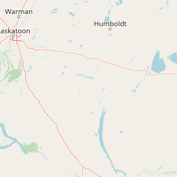
Map view of St. Denis National Wildlife Area

Use this park location map to pinpoint St. Denis National Wildlife Area in Canada, understand its exact geographic position, and read its mapped placement within the surrounding landscape more clearly.

Pigeon | © OpenStreetMap contributors

Location context for St. Denis National Wildlife Area

Saskatchewan
Park atlas

Compare surrounding prairie reserves, wetland habitats, and connected conservation terrain.

Explore Parks Near St. Denis National Wildlife Area and Regional Protected Landscapes

Browse other parks near St. Denis National Wildlife Area to examine similar prairie wetland ecosystems and regional protected terrain. Continuing into wider geographic comparisons reveals broader ecological patterns across the surrounding Saskatchewan landscape.
Protected areaSutherland
About 34 km away#1 closest

West

Zugvogelschutzgebiet Sutherland: Regional Geography and Protected Area Context

Historic migratory bird habitat in the Saskatchewan prairie landscape

The Zugvogelschutzgebiet Sutherland protected area serves as an important migratory refuge on the Canadian Prairies. While the site integrates diverse land uses including a zoo and research facilities, its remaining native grasslands continue to provide essential feeding and resting grounds for geese, swans, and ducks. This analysis maps the sanctuary within its broader regional context.

Area
1.3 km²
Established
1924
Relief
Lowland
Climate
Temperate
Wildlife reserveSaskatchewan
About 79 km away#2 closest

East

Raven Island National Wildlife Area: Geographic Overview and Protected Island Landscape

Essential conservation geography within Saskatchewan

Located in the saline prairie basins of central Saskatchewan, Raven Island National Wildlife Area is a 112-hectare protected habitat. This site plays a strategic role in the Lenore Lake migratory bird complex, preserving crucial island breeding grounds within a gentle prairie landscape. Explore the physical boundaries and ecological context of this Canadian wildlife reserve.

Area
1.12 km²
Established
1982
IUCN
IV
Scope
Terrestrial
Wildlife reserveSaskatchewan
About 117 km away#3 closest

Northwest

Thickwood Hills National Wildlife Area: Geography and Protected Landscape Analysis

A study of transitional Saskatchewan prairie and aspen ecosystems

Located northeast of Blaine Lake, this Canadian wildlife reserve encompasses a precise 299-hectare footprint. The site serves as a vital example of regional conservation, maintaining wetlands and native grasslands that define the transition between open prairie and northern boreal forest landscapes.

Area
2.99 km²
Established
2025
IUCN
IV
Relief
Lowland
Wildlife reserveSaskatchewan
About 119 km away#4 closest

Southwest

Harris Sandhills National Wildlife Area: Saskatchewan Protected Prairie Geography and Map

Mapped wildlife reserve within the Canadian prairie region.

This protected area in Saskatchewan showcases a distinct mosaic of stabilized dunes and native mixed-grass prairie. Understand its geographic significance as a sanctuary for migratory birds and rare prairie species within the expansive plains of Canada. The reserve offers a focused look at small-scale conservation landscapes through its defined physical boundaries and varied topographic features.

Area
3.7 km²
Established
2025
IUCN
IV
Relief
Lowland
National parkSaskatchewan
About 152 km away#5 closest

North

Prince Albert National Park: Saskatchewan National Park and Protected Area Geography

Mapped Landscape Boundaries and Regional Natural Terrain Context

Prince Albert National Park represents a distinct national park entity within Saskatchewan, vital for understanding regional geography and protected landscapes. This page offers detailed insights into its mapped boundaries and the surrounding natural terrain. It is designed to help users comprehend the park's specific protected area identity and its contribution to the broader geographic atlas of Canada's natural spaces.

Area
3,874 km²
Established
1927
IUCN
II
Visitors
287.4K annual
Wildlife reserveSaskatchewan
About 162 km away#6 closest

Northwest

Scent Grass Lake Migratory Bird Sanctuary: Regional Geography and Wetland Protected Area Maps

Key waterfowl breeding and molting ground in Saskatchewan.

Examine the ecological significance of Scent Grass Lake Migratory Bird Sanctuary, a critical wildlife reserve within the Saskatchewan Aspen Parkland. This protected area offers essential open water and sedge marsh environments for migratory waterfowl, serving as a vital staging and breeding site that maintains regional habitat stability in the Canadian prairies.

Area
6.47 km²
Established
1948
IUCN
IV
Relief
Lowland
Wildlife reserveSaskatchewan
About 222 km away#7 closest

Southeast

Wascana Lake Migratory Bird Sanctuary: Geographic Overview and Protected Wetland Boundaries

A vital wildlife reserve located in Regina, Saskatchewan

Explore the unique geography of Wascana Lake Migratory Bird Sanctuary, where a managed reservoir creates a rich wetland habitat for migratory waterfowl. This protected area stands as a significant ecological site within the Saskatchewan prairie landscape, offering a rare look at riparian terrain integration inside a major urban center.

Area
1.04 km²
Established
1956
Relief
Lowland
Climate
Temperate
Wildlife reserveSaskatchewan
About 230 km away#8 closest

East

Neely Lake Migratory Bird Sanctuary: Boreal Wetland Geography and Protected Landscapes

Essential protected area data for the eastern Saskatchewan boreal fringe

Neely Lake Migratory Bird Sanctuary encompasses a shallow freshwater environment defined by marshy shorelines, wet meadows, and small islands. Situated within the Mid-Boreal Upland, this protected landscape provides crucial stopover habitat for waterfowl moving through the Prairie and Boreal flyways. Gain insight into the terrain, water-body structure, and ecological role of this significant Canadian wildlife reserve.

Area
5.02 km²
Established
1952
IUCN
IV

Common questions about visiting, size, designation, and location context for St. Denis National Wildlife Area

St. Denis National Wildlife Area FAQs for park facts, access, geography, and protected area context

Find quick answers about St. Denis National Wildlife Area, including protected-area facts, park geography, trail and visitor context, and how the park fits into its surrounding country and regional landscape.
MoriAtlas Explorer

Continue Your Protected Areas Search Across the Global Atlas

Deepen your exploration by continuing the structured search for national parks and protected areas worldwide. Utilize the comprehensive filtering capabilities to compare different conservation landscapes and refine your understanding of global park geography. Discover more about the distribution and characteristics of protected natural areas.

Global natural geography