Mori Atlas logo
Nature reserveSteinernes Meer Nature Reserve

Examine the dense boulder fields, forest-covered hillsides, and ancient geological heritage within this protected landscape.

Steinernes Meer Nature Reserve: Mapping Glacial Erratic Landscapes in the Osnabrück Region

(Naturschutzgebiet Steinernes Meer)

Steinernes Meer Nature Reserve preserves a unique concentration of massive glacial erratic boulders deposited during the Saalian glaciation. Located in the Osnabrück district, the reserve features a gently rolling, forest-clad hillside that stands in contrast to the surrounding lowland terrain. Through its geological significance as a natural monument, the area serves as a focal point for understanding the long-term impact of Ice Age processes on the modern landscape of northern Germany.

geological heritageglacial erraticsboulder fieldIce Age landscapenature reserveLowland forest

Steinernes Meer Nature Reserve

Nature reserve

Park overview

Structured park overview, official facts, and landscape profile for Steinernes Meer Nature Reserve

Steinernes Meer Nature Reserve park facts, protected area profile, and essential visitor context

Review the core facts for Steinernes Meer Nature Reserve, including designation, size, terrain, visitor scale, habitats, and operating context in one park-focused overview.

About Steinernes Meer Nature Reserve

Steinernes Meer Nature Reserve is a compact but unusually distinctive protected site in the Osnabrück district of Lower Saxony, located on the wooded northeastern slope of the Gattberg in the municipality of Belm. Measuring just 12.7 hectares and composed of two separate sections, the reserve's modest size belies its striking geological character and its long-standing cultural resonance.

The reserve's defining feature is a dense field of glacial erratic boulders, locally described as a "stone sea." These large findlings, including stones reaching up to roughly 3.80 meters in height, were carried south from Scandinavia during the Saaleeiszeit, or Saalian glaciation, when Pleistocene ice sheets dragged rock debris across northern Europe. Concentrations of this many large boulders in a small upland forest setting are uncommon in the lowlands of northwestern Germany, giving the site an almost monumental quality within an otherwise rural landscape.

Designated as a nature reserve under the code NSG WE 005, Steinernes Meer forms a small but meaningful component of the broader TERRA.vita Nature and Geopark. This larger regional framework highlights geological heritage sites across the Osnabrück region and beyond, situating the reserve within a wider story of landscape formation. The wooded hillside setting of the Gattberg, combined with the open glacial boulder field, makes the site both an accessible excursion into Ice Age history and a quiet natural retreat within the densely populated Osnabrück area.

The reserve has been recognized for over a century. It was first placed under protection in November 1924, was preserved as a natural monument, and was formally re-established under the Reich Nature Conservation Act in 1937. Today it remains an important local landmark and a notable example of how small Lower Saxon reserves can preserve nationally significant geological and prehistoric heritage.

Quick facts and research context for Steinernes Meer Nature Reserve

Steinernes Meer Nature Reserve lies northeast of Osnabrück in the municipality of Belm, Lower Saxony, occupying the wooded northeastern slope of the Gattberg hill. It covers roughly 12.7 hectares and is split into two separate sections, with the official designation NSG WE 005.

The reserve is managed by the Lower Saxon Agency for Water Management, Coastal Protection, and Nature Conservation (NLWKN), with the Osnabrück district serving as the responsible lower nature protection authority. It has been protected as a natural monument since 1924 and formally re-established under nature conservation law on 7 August 1937.

Protection and recognition

Examine official terrestrial conservation records and designated management parameters

Steinernes Meer Nature Reserve Protection Status and Territorial Designation

Steinernes Meer Nature Reserve maintains a documented terrestrial protection status within official conservation databases. Designated parameters compile baseline management scope and verified international data records.

Protection details

Protection scope
Terrestrial
Transboundary protection
No
WDPA ID
82631
Park context

Deeper park guide and search-rich context for Steinernes Meer Nature Reserve

Steinernes Meer Nature Reserve history, landscape, wildlife, and travel context

Explore Steinernes Meer Nature Reserve through its history, landscape character, ecosystems, wildlife, conservation priorities, cultural context, and seasonal travel timing in a structured park guide built for atlas discovery and search intent.

Why Steinernes Meer Nature Reserve stands out

Steinernes Meer is best known for its remarkable concentration of glacial erratic boulders, an unusually rich assemblage of large stones deposited by the Saalian glaciation. The site's signature feature, the Butterstein, stands apart as the largest of these boulders and has been linked to prehistoric ritual use, lending the reserve both geological and archaeological significance. The reserve's identity is also shaped by its position within the TERRA.vita geopark landscape, where ancient stones and gently wooded lowland hills together illustrate the deep geological history of northwestern Germany. The combination of dense forest cover, glacial history, and prehistoric association gives the reserve a distinctive profile among German nature reserves, despite its compact size.
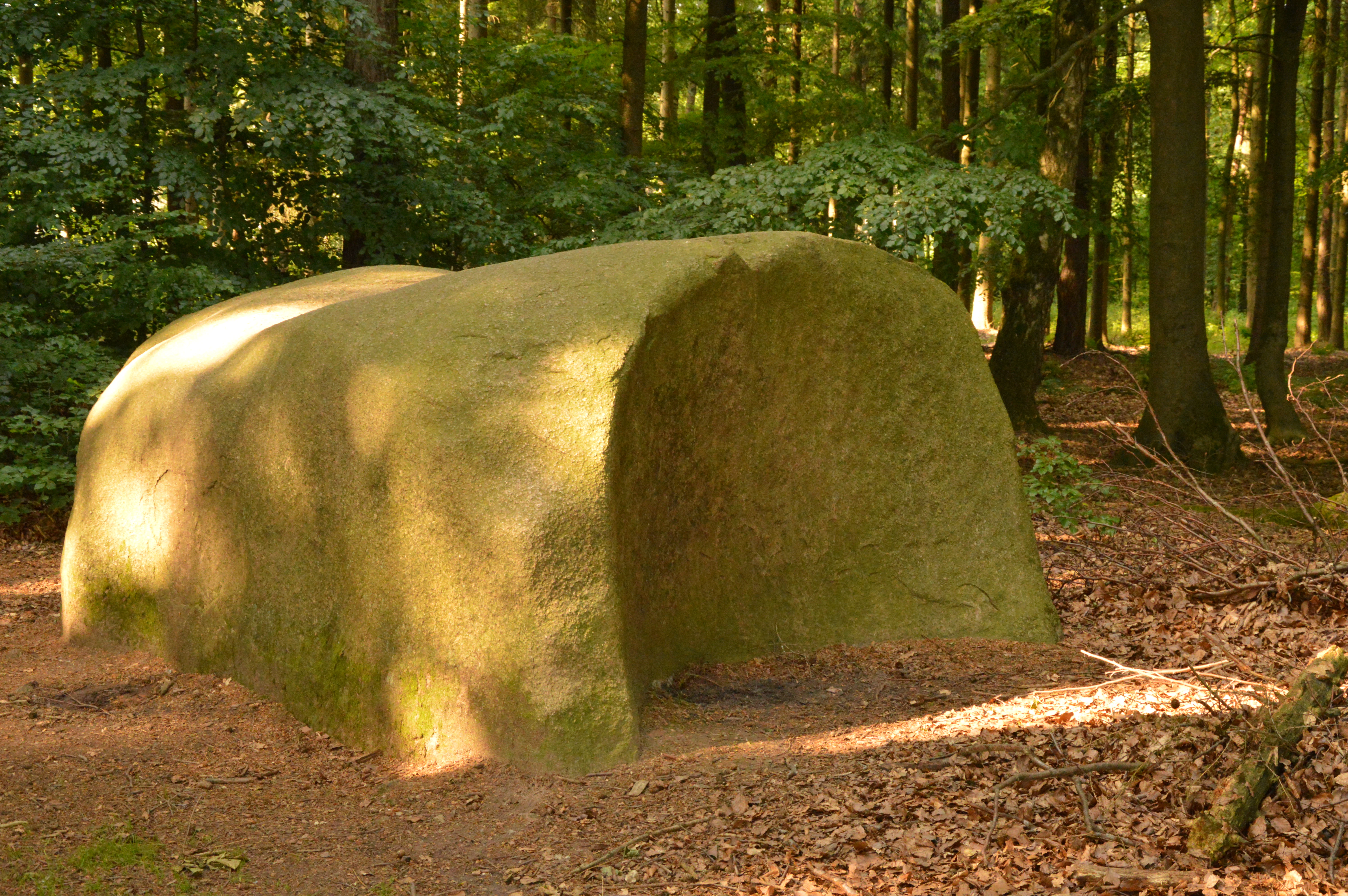
A large, smooth, moss-covered rock formation shaped like a loaf of bread sits on a forest floor covered in brown leaves, surrounded by trees.
The Butterstein rock formation, a large moss-covered boulder, situated in a forest within the Steinernes Meer Nature Reserve.

Steinernes Meer Nature Reserve history and protected-area timeline

The Steinernes Meer has been protected as a natural monument since 8 November 1924, when the boulder field was first placed under the field and forest police law to safeguard its cluster of glacial erratic boulders from damage or removal.

In 1937, the protection regime was reorganized under the new Reich Nature Conservation Act, and the official effective date of the reserve's ordinance was set to 7 August 1937, which remains the most commonly cited establishment date for the protected area. The handover of legal authority reflected a broader national reorganization of nature protection in Germany at that time.

Responsibility for the reserve today rests with the Osnabrück district as the lower nature protection authority, while the Lower Saxon Agency for Water Management, Coastal Protection, and Nature Conservation (NLWKN) supports its management. The site has thus retained continuous protection across several distinct legal and political eras in German conservation history.

Steinernes Meer Nature Reserve landscape and geographic character

The landscape of Steinernes Meer Nature Reserve is defined by a gently rolling wooded hillside on the northeastern slopes of the Gattberg, a modest elevation within the otherwise flat surroundings of the Osnabrück area. The reserve sits between approximately 128 and 143 meters above sea level, an unusual rise that gives the site a more sheltered and visually enclosed forest character than much of northwestern Germany.

The defining geological feature is the dense scattering of glacial erratic boulders, or findlings. These large stones, transported by Pleistocene ice during the Saalian glaciation, appear together in such numbers that the forest floor takes on the appearance of a stony sea from which the reserve takes its name. Among them, the monumental Butterstein stands slightly apart along the southern edge of the area, its sheer size and isolation giving it a distinctive visual presence that has long drawn visitors to the site.

Overall, the landscape is a striking juxtaposition of dense lowland forest and exposed glacial stone, illustrating how Ice Age processes continue to shape the surface character of this part of Germany long after the ice itself retreated.

Steinernes Meer Nature Reserve ecosystems, habitats, and plant life

The ecological character of the Steinernes Meer is shaped by its wooded lowland setting on the slopes of the Gattberg, dominated by forest cover that surrounds and weaves between the scattered glacial boulders. This forested hillside habitat is typical of the protected forest patches maintained across the Osnabrück district, offering habitat continuity and shelter for woodland species.

The boulder field itself creates additional microhabitats within the forest. Stones of varying size and surface texture provide crevices, shaded surfaces, and small clearings that support mosses, lichens, and other rock-dwelling vegetation, while the intermittent leaf litter and soil pockets between boulders support small-scale plant communities.

While the reserve is small in extent, its integration into the broader TERRA.vita Nature and Geopark means that the site's natural values are understood within a wider regional context of forest preservation and geoconservation across northern Germany.

Steinernes Meer Nature Reserve wildlife and species highlights

Given its compact 12.7 hectare size and dense forest setting, Steinernes Meer is not primarily a destination for high-volume wildlife viewing, but the wooded Gattberg slopes and boulder field together support characteristic woodland fauna typical of Lower Saxony. Forest birds, small mammals, and invertebrates benefit from the structural variety created by trees, leaf litter, and the sheltered spaces around large boulders.

The site's particular value lies more in preserving the physical habitat conditions for these communities than in harboring rare or flagship species. The continuity of forest cover, combined with the protected status of the boulder field, ensures that the microhabitats beneath and around the erratic stones remain undisturbed, supporting the broader woodland ecosystem rather than a single species assemblage.

Steinernes Meer Nature Reserve conservation status and protection priorities

Steinernes Meer Nature Reserve has been protected for its geological and cultural significance for nearly a century, making it an unusually long-standing Lower Saxon conservation site. Its primary conservation value lies in the preservation of a rare in-situ concentration of glacial erratic boulders, geological evidence of the Saalian glaciation that shaped much of northern Europe.

By safeguarding the boulders from removal or disturbance, the reserve protects a tangible record of Pleistocene climate history. Its inclusion within the TERRA.vita Nature and Geopark strengthens this conservation role, embedding the site within a broader regional framework that promotes the protection and public understanding of geological heritage.

Although small, the reserve also contributes to the conservation of contiguous woodland habitat on the Gattberg slopes, demonstrating how even very compact German nature reserves can combine geological, ecological, and cultural protection objectives.

Steinernes Meer Nature Reserve cultural meaning and human context

The cultural identity of Steinernes Meer is inseparable from its glacial landscape and its long association with folklore and prehistoric imagination. The Butterstein, the largest boulder in the field, has been interpreted as a possible prehistoric sacrificial or ritual stone, suggesting that the site held symbolic or ceremonial meaning for communities living in the region in prehistoric times.

The evocative name "Steinernes Meer," or "Stone Sea," itself reflects a long tradition of folk interpretation of dramatic natural features. The reserve, though a formal 20th-century protection entity, stands at the intersection of ancient human imagination and modern geoconservation, with the surrounding region holding many similar traces of prehistoric stone use.

Top sights and standout views in Steinernes Meer Nature Reserve

The Steinernes Meer offers a compact but layered experience centered on one of northern Germany's most accessible concentrations of glacial erratic boulders. Visitors encounter a wooded hillside setting unusual for the Osnabrück area, a forest floor strewn with Ice Age stones, and the dramatic Butterstein, the largest boulder in the field and a possible prehistoric ritual site.

The reserve's long protection history, its geological value as evidence of the Saalian glaciation, and its position within the TERRA.vita geopark give it an importance that goes well beyond its modest 12.7 hectare footprint, making it a small but distinctive destination for those interested in the deep history of the German landscape.

Best time to visit Steinernes Meer Nature Reserve

The reserve can be appreciated year-round thanks to its deciduous and mixed forest setting, but spring and early autumn tend to offer the most comfortable conditions for walking the uneven boulder-strewn terrain. In spring, fresh leaf cover and forest blooms brighten the slope of the Gattberg, while in autumn the seasonal colors contrast strongly with the grey glacial stones.

Winter visits reveal the boulder field most starkly, with bare trees exposing the full scale of the "stone sea," though visitors should expect cooler temperatures on the exposed north-facing slope.

Monthly climate preview

Long-term temperature ranges and monthly precipitation averages for Bavaria

Steinernes Meer Nature Reserve Climate Normals and Annual Weather Patterns

Historical climate data for Steinernes Meer Nature Reserve records average monthly temperatures ranging from sub-zero winter minimums to warm summer maximums alongside steady precipitation rates. Reviewing the complete twelve-month record provides deeper insight into long-term atmospheric patterns and regional weather rhythms.
Annual mean9 °C
1 °C18 °C
Jan
Feb
Mar
Apr
May13°
Jun16°
Jul18°
Aug18°
Sep14°
Oct10°
Nov
Dec
Warmest month
July

18.4 °C

Coolest month
January

1.1 °C

Wettest month
December

2.3 mm/day

Driest month
April

1.4 mm/day

Park location guide

Geography guide, regional context, and park location map for Steinernes Meer Nature Reserve

Steinernes Meer Nature Reserve park geography, regions, and map view in Germany

Understand where Steinernes Meer Nature Reserve sits in Germany through a broader geographic reading of the surrounding landscape, nearby location context, and its mapped position within the national park landscape.

How Steinernes Meer Nature Reserve fits into Germany

Germany is a federal republic in Western and Central Europe with a population of over 83 million across sixteen constituent states. It is Europe's largest economy by nominal GDP and a major global exporter and importer. The capital is Berlin, and the country borders Denmark, Poland, Czech Republic, Austria, Switzerland, France, Luxembourg, Belgium, and the Netherlands.

Wider geography shaping Steinernes Meer Nature Reserve in Germany

Germany is located in Western and Central Europe, spanning 357,022 km². It borders Denmark to the north, Poland and the Czech Republic to the east, Austria and Switzerland to the south, and France, Luxembourg, Belgium, and the Netherlands to the west. The country has coastlines on the Baltic Sea and North Sea to the north, with the Alps located in the southern region.

Map view of Steinernes Meer Nature Reserve

Use this park location map to pinpoint Steinernes Meer Nature Reserve in Germany, understand its exact geographic position, and read its mapped placement within the surrounding landscape more clearly.

Pigeon | © OpenStreetMap contributors

Location context for Steinernes Meer Nature Reserve

BavariaSalzburg

Visual reference for glacial erratic boulders, woodland terrain, and geological heritage.

Steinernes Meer Nature Reserve Photos, Scenery, and Glacial Landscapes

Photographic collections reveal the dense forest canopy, sheltered hillside terrain, and scattered Ice Age boulders defining Steinernes Meer Nature Reserve. Visual documentation allows researchers and travelers to examine the distinct geological character and protected landscapes of this German geopark.

A large, smooth, moss-covered rock formation shaped like a loaf of bread sits on a forest floor covered in brown leaves, surrounded by trees.

Park atlas

Compare nearby regional parks and connected protected landscapes across northern Germany

Other Parks Near Steinernes Meer Nature Reserve and Surrounding Protected Areas

Browse protected areas and regional nature reserves located near Steinernes Meer Nature Reserve. Extending your geographic comparison reveals broader geological patterns and woodland terrain across the surrounding territory.
Nature reserveLandkreis Osnabrück
About 12 km away#1 closest

North

Venner Moor Nature Reserve: Geography and Peatland Conservation in Landkreis Osnabrück

A legacy of industrial peat mining and wetland restoration

Venner Moor preserves a diverse peatland ecosystem featuring distinct zones of birch woodland and open, industrially scarred terrain. This protected area in Landkreis Osnabrück serves as a primary example of mire renaturation, where infrastructure like old railway lines illustrates the historical human imprint on the German landscape.

Area
2.18 km²
Established
1992
IUCN
IV
Nature reserveLower Saxony
About 17 km away#2 closest

Northeast

Streithorst Nature Reserve: Alluvial Woodland and River Lowlands in Lower Saxony

Protected floodplain forest and riparian geography

Located in the Osnabrück district, Streithorst functions as a vital nature reserve representing the rare ash and elm alluvial forests of the Hunte valley. This site, originating from a historic manor park, offers a concentrated look at riparian stream dynamics and mature woodland habitats surrounded by the agricultural plains of Lower Saxony.

Area
0.069 km²
Established
1982
IUCN
IV
Nature reserveLandkreis Osnabrück
About 21 km away#3 closest

Northeast

Westliche Dümmerniederung im Landkreis Osnabrück: Protected Wetland Landscape and Map

Extensive wet grassland and fen reserve in Lower Saxony

Covering roughly 490 hectares, the Westliche Dümmerniederung im Landkreis Osnabrück stands as one of the largest contiguous wet grassland complexes in northwestern Germany. The reserve features a dense pattern of drainage ditches, reedbeds, and rewetted meadows that sustain critical populations of breeding waders and migratory birds. Its flat, open terrain offers a clear look at the historic lowland fen geography characteristic of the Dümmer basin region.

Area
4.9 km²
Established
2023
Relief
Lowland
Climate
Temperate
A wide watercolor illustration showing a green landscape with a winding white path or stream, pink blossoming trees, and distant purple mountains under a pale sky.
Nature reserveNorth Rhine-Westphalia
About 25 km away#4 closest

Southeast

Kilverbachtal Nature Reserve: Protected Valley Geography in North Rhine-Westphalia

A refined look at lowland stream morphology and regional riparian habitats.

Kilverbachtal preserves a rare example of a narrow, box-shaped stream valley known as a Siek. This protected landscape features a mosaic of wet meadows, alder-lined riparian zones, and forested slopes that cut through the agricultural terrain of North Rhine-Westphalia. The area acts as a vital refugium for specialized flora and fauna, providing deep insight into the regional natural heritage and geological character of northwestern Germany.

Area
1.07 km²
Relief
Lowland
Climate
Temperate
Access
Access unknown
Watercolor painting of a rolling forested landscape with hills in the background and a gentle valley floor in the foreground, rendered in soft green and earth tones.
Nature reserveNorth Rhine-Westphalia
About 26 km away#5 closest

East

Limberg und Offelter Berg: Exploring Protected Forest Landscapes in North Rhine-Westphalia

Nature reserve geography and Wiehen Hills woodland terrain

Limberg und Offelter Berg is a foundational nature reserve in eastern Westphalia, known for its well-preserved beech forest mosaic and the protected headwaters of the Landwehrbach. Positioned on the eastern ridge of the Wiehen Hills, the area features a varied terrain of forested slopes and small valleys. It remains a critical study area for native woodland communities, reflecting eight decades of continuous landscape protection in the Minden-Lübbecke district.

Area
1.861 km²
Established
1935
Relief
Upland
Scope
Terrestrial
Watercolor painting of a rolling forested landscape with hills and a central water feature, stylized with soft green and peach tones.
Nature reserveNorth Rhine-Westphalia
About 27 km away#6 closest

Southeast

Johannisegge-Schornstein Nature Reserve: Protected Woodland and Ridge Terrain Atlas

Exploring the Teutoburg Forest ridge geography in North Rhine-Westphalia.

Johannisegge-Schornstein stands as a vital nature reserve in Borgholzhausen, characterized by its exposed beech stands and its position on the Teutoburg Forest ridge. The reserve offers a clear look at historic coppice woodland management and local watershed geography, stretching from the rocky Bönkersche Steinbruch quarry to the prominent Luisenturm lookout point.

Area
2.255 km²
Established
2001
IUCN
IV
Relief
Mountain
Nature reserveNiedersachsen
About 29 km away#7 closest

Northeast

Westliche Dümmerniederung Nature Reserve: Regional Geography and Wetland Atlas

Protected marshlands and peatland landscapes in Niedersachsen

Spanning roughly 996 hectares within the districts of Vechta and Diepholz, Westliche Dümmerniederung represents a significant wetland complex in northwestern Germany. The reserve consists of wet pastures, hay meadows, and alder carr forests, forming a coherent part of the Dümmer basin protected landscape. This atlas record provides context on the physical boundaries and ecological composition of this vital lowland terrain.

Area
9.96 km²
Established
1952
IUCN
IV
Nature reserveVechta District
About 32 km away#8 closest

North

Steinfelder Moor Nature Reserve: Geography and Protected Wetland Boundaries in Vechta District

A study of raised bog terrain and regional peatland conservation.

Steinfelder Moor preserves a unique fragment of the North German Plain's raised bog heritage. Located within the Vechta District, this nature reserve integrates historical peat-cut zones with ongoing rewetting efforts, creating a distinctive mosaic of waterlogged basins and bog woodland. The site offers a clear view into the internal geography of an active wetland, framing how regional protected areas maintain ecological structure in the wider Diepholzer Moorniederung.

Area
2.88 km²
Established
1986
IUCN
IV

Common questions about visiting, size, designation, and location context for Steinernes Meer Nature Reserve

Steinernes Meer Nature Reserve FAQs for park facts, access, geography, and protected area context

Find quick answers about Steinernes Meer Nature Reserve, including protected-area facts, park geography, trail and visitor context, and how the park fits into its surrounding country and regional landscape.
MoriAtlas Explorer

Continue Your Protected Areas Search Across the Global Atlas

Deepen your exploration by continuing the structured search for national parks and protected areas worldwide. Utilize the comprehensive filtering capabilities to compare different conservation landscapes and refine your understanding of global park geography. Discover more about the distribution and characteristics of protected natural areas.

Global natural geography