
Mori Atlas logo
Nature reserveWestliche Dümmerniederung

Analyzing the wetland terrain, fen meadow habitats, and ecological boundaries of the Dümmer basin

Westliche Dümmerniederung Nature Reserve: Mapped Protected Landscapes in Niedersachsen

(Naturschutzgebiet Westliche Dümmerniederung)

Westliche Dümmerniederung serves as a critical nature reserve within the northwestern German lowlands of Niedersachsen. This protected area encompasses vast fen meadows, marshy grasslands, and reedbeds that define the ecological character of the Dümmer basin. Through detailed mapping and landscape analysis, observers can examine the interconnected habitats that support diverse wetland species and the historical peatland terrain of the region.

wetland nature reservelowland fenswet meadowsreedbedspeatland landscapebird protection area
Digital illustration of a mountain landscape featuring a waterfall cascading between cliffs, a winding river, coniferous forests, and a marshy foreground with tall grasses.

Westliche Dümmerniederung

Nature reserve

Park overview

Structured park overview, official facts, and landscape profile for Westliche Dümmerniederung

Westliche Dümmerniederung park facts, protected area profile, and essential visitor context

Review the core facts for Westliche Dümmerniederung, including designation, size, terrain, visitor scale, habitats, and operating context in one park-focused overview.

About Westliche Dümmerniederung

Westliche Dümmerniederung is a Lower Saxony nature reserve situated in the Dümmer lowlands, west of the Hunte River and the Dümmer lake. The protected area covers about 996 hectares, with the vast majority, roughly 993 hectares, located in the district of Vechta and a small portion in the district of Diepholz. It lies near the town of Damme within the broader Dümmer basin, a region characterized by flat, formerly peat-rich terrain that has long been shaped by drainage, grazing, and hay-making.

The reserve functions as a key component of the wider Dümmer conservation landscape, which together with the adjoining "Huntebruch und Huntebruchwiesen" and "Dümmer, Hohe Sieben und Ochsenmoor" nature reserves covers a substantial share of the Dümmer lowlands under national protection. Westliche Dümmerniederung is itself part of the EU Birds Directive area "Dümmer", and a smaller portion also lies within the EU Habitats Directive site of the same name, underlining its importance for both international bird protection and habitat conservation.

Ecologically, the reserve represents a characteristic example of intensively managed but ecologically valuable lowland fen and wet grassland country. Its identity is defined by low-mire soils, seasonally wet and permanently waterlogged ground, and a mosaic of habitat types that together create conditions attractive to waders, waterfowl, and other wetland wildlife typical of the northwestern German plain.

Quick facts and research context for Westliche Dümmerniederung

Westliche Dümmerniederung is a Lower Saxony nature reserve situated in the Dümmer lowlands west of Damme and south of Diepholz, crossing the districts of Vechta and Diepholz. It was placed under protection on 22 March 1952 and is administered under the designation NSG WE 262. With about 996 hectares, the reserve forms part of the EU Bird Protection Area "Dümmer" and partly overlaps with the EU Habitats Directive site "Dümmer". The landscape is dominated by fens, wet meadows, reedbeds, tall herb communities, and small areas of carr forest, shaped by long-standing grassland use.

Protection and recognition

Examine official designation records and management frameworks for Westliche Dümmerniederung.

Westliche Dümmerniederung Protection Status and Documented International Recognition

Westliche Dümmerniederung features verified protection status records and structured conservation entries for regional analysis. Review documented administrative frameworks and official designation details associated with global database identifiers.

Protection details

WDPA ID
378381
Park context

Deeper park guide and search-rich context for Westliche Dümmerniederung

Westliche Dümmerniederung history, landscape, wildlife, and travel context

Explore Westliche Dümmerniederung through its history, landscape character, ecosystems, wildlife, conservation priorities, cultural context, and seasonal travel timing in a structured park guide built for atlas discovery and search intent.

Why Westliche Dümmerniederung stands out

The reserve is best known for its extensive fen meadows and marshland habitats in the Dümmer lowlands, and for its role as a component of the EU Birds Directive site "Dümmer". Its mix of pasture, hay meadow, reedbed, and sedge communities makes it one of the larger cohesive wetland habitat complexes around the Dümmer basin.
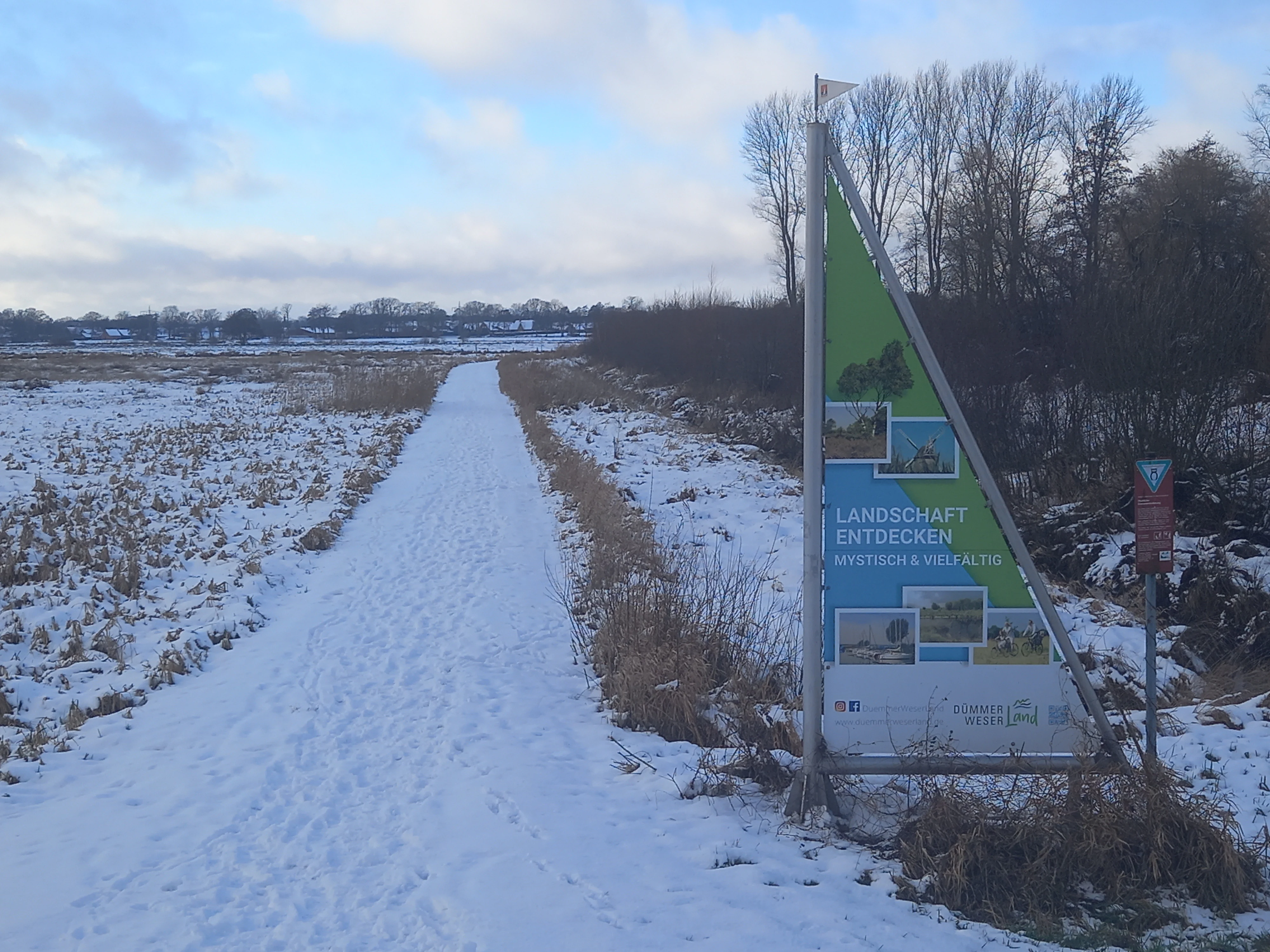
A snow-covered trail winds through a winter landscape, with a triangular informational signpost in the foreground reading Landschaft entdecken.
A snow-covered path leading into the Westliche Dümmerniederung nature reserve, marked by an informative signage pillar.

Westliche Dümmerniederung history and protected-area timeline

The area has been under nature protection since 22 March 1952, making Westliche Dümmerniederung one of the older reserves in the region. Over the decades its boundaries have been adjusted to reflect evolving administrative and ecological priorities. A major revision came with the regulation of 14 December 2007, which deleted a roughly 125-hectare portion of the overlapping "Dümmer" nature reserve; that area remained part of Westliche Dümmerniederung rather than dropping out of protection altogether. On 1 January 2023 the approximately 436-hectare share of the reserve lying in the district of Osnabrück was separated out and redesignated as its own distinct nature reserve, "Westliche Dümmerniederung im Landkreis Osnabrück", leaving the present reserve focused on the Vechta and Diepholz sections. The responsible authorities are the districts of Vechta and Diepholz, with the NLWKN managing broader oversight of protected areas in Lower Saxony.

Westliche Dümmerniederung landscape and geographic character

The reserve lies in the flat lowlands of the Dümmer basin, with surface elevations ranging only from about 37 meters down to 30 meters above sea level. Its terrain is shaped by low peatlands and former mire country, intersected by subtle drainage patterns rather than dramatic relief. To the east the reserve meets adjoining protected areas tied to the Hunte and Dümmer systems, while to the west and southwest it borders the wider Dümmer landscape protection area and the now-separate Osnabrück portion of the reserve.

Visually, the landscape is a quiet mosaic of open, low-lying ground with little vertical structure but strong seasonal variation: hay meadows, grazed pastures, reed margins, and small carr woodland stands. The result is a wide, open, marshy countryside typical of the northwestern German plain, where the horizon is generally low and the land reads as a continuous stretch of green pastoral wetland rather than as dramatic topography.

Westliche Dümmerniederung ecosystems, habitats, and plant life

Ecologically, Westliche Dümmerniederung is defined by its low-mire and wet grassland habitats, a habitat complex that is increasingly rare in intensively farmed northwest German landscapes. The reserve contains wet and moist meadows used as pasture and hay meadows, tall herb fringe vegetation, large sedge beds, reedbeds, and small patches of carr forest associated with the Osterfeiner Moor in the northern part of the protected area.

These habitats form a connected mosaic that supports the hydrological and ecological functioning of the broader Dümmer wetland system. Their long continuity of agricultural management, combined with formal protection, has allowed the survival of habitat types that have been heavily lost elsewhere in the region, making the reserve an important reservoir of lowland wetland character rather than an isolated fragment.

Westliche Dümmerniederung wildlife and species highlights

The reserve's combination of open wet meadows, reedbeds, and standing or slowly flowing water makes it particularly significant for waterbirds and wetland-dependent species, which is why the whole area forms part of the EU Birds Directive site "Dümmer". Its habitats are typical of those used by waders, wildfowl, and reedbed-associated birds in the Dümmer basin, while the wet grassland margins also support amphibians and invertebrates associated with fen systems. The diverse vegetation structure, from short grazed turf to tall reed and sedge stands, creates niches for a range of fauna rather than a single dominant group.

Westliche Dümmerniederung conservation status and protection priorities

Westliche Dümmerniederung has clear conservation significance at both regional and European levels. It is part of the EU Birds Directive protected area "Dümmer", recognizing its importance for migratory and breeding waterbirds, and a smaller portion is included in the EU Habitats Directive site "Dümmer" for habitat-based protection. Together with neighbouring reserves such as Huntebruch und Huntebruchwiesen and Dümmer, Hohe Sieben und Ochsenmoor, it secures a substantial share of the Dümmer lowlands under national protection.

The reserve's long-standing designation, dating back to 1952, reflects the recognized value of its fen meadows, reedbeds, and associated wetland habitats in a landscape that has otherwise seen extensive agricultural conversion. Maintaining the continuity of these habitats, and the traditional grassland management that shapes them, is at the core of the area's conservation role.

Westliche Dümmerniederung cultural meaning and human context

The Dümmer lowlands have a long history of human use, with the wet grasslands traditionally managed as pasture and hay meadows that both sustained local farming and created the open habitat conditions the reserve still depends on. The reserve is embedded in a working agricultural landscape between the towns of Damme and Diepholz, and small settlements such as Dümmerlohausen sit at its edges, where marked entrances link the protected area to public walking routes around the Dümmer. This continuity of rural land use is a defining part of the reserve's character.

Top sights and standout views in Westliche Dümmerniederung

Westliche Dümmerniederung stands out for its scale within the Dümmer basin, its long history of formal protection since 1952, and its status as part of the EU Birds Directive site "Dümmer". The reserve's mix of fen meadows, wet pasture, tall herb vegetation, large sedge stands, reedbeds, and small carr woodlands gives it a habitat density that is now uncommon in the intensively used agricultural plains of northwestern Germany.

Best time to visit Westliche Dümmerniederung

Spring and early summer generally offer the richest experience of the reserve's wet meadows and breeding bird activity, when water levels are typically higher and vegetation is most expressive. Late summer and early autumn can also be rewarding, especially for visible migratory bird movements through the Dümmer basin. In winter, the open marshy landscape often hosts concentrations of waterfowl, though conditions can be damp and access infrastructure is mainly oriented around walking and observation rather than formal visitor amenities.


Monthly climate preview

Examine the long-term meteorological baseline and month-by-month temperature progression

Westliche Dümmerniederung Climate Normals, Annual Temperature and Precipitation Rhythm

Historical data recorded between 1991 and 2000 at a representative coordinate tracks monthly temperature variation alongside daily precipitation rates across Westliche Dümmerniederung. Detailed climatological records provide complete twelve-month distributions for comparative environmental analysis.
Annual mean9 °C
1 °C18 °C
Jan
Feb
Mar
Apr
May13°
Jun16°
Jul18°
Aug18°
Sep14°
Oct10°
Nov
Dec
Warmest month
July

18.4 °C

Coolest month
January

1.1 °C

Wettest month
December

2.3 mm/day

Driest month
April

1.4 mm/day

Park location guide

Geography guide, regional context, and park location map for Westliche Dümmerniederung

Westliche Dümmerniederung park geography, regions, and map view in Germany

Understand where Westliche Dümmerniederung sits in Germany through a broader geographic reading of the surrounding landscape, nearby location context, and its mapped position within the national park landscape.

How Westliche Dümmerniederung fits into Germany

Germany is a federal republic in Western and Central Europe with a population of over 83 million across sixteen constituent states. It is Europe's largest economy by nominal GDP and a major global exporter and importer. The capital is Berlin, and the country borders Denmark, Poland, Czech Republic, Austria, Switzerland, France, Luxembourg, Belgium, and the Netherlands.

Wider geography shaping Westliche Dümmerniederung in Germany

Germany is located in Western and Central Europe, spanning 357,022 km². It borders Denmark to the north, Poland and the Czech Republic to the east, Austria and Switzerland to the south, and France, Luxembourg, Belgium, and the Netherlands to the west. The country has coastlines on the Baltic Sea and North Sea to the north, with the Alps located in the southern region.

Map view of Westliche Dümmerniederung

Use this park location map to pinpoint Westliche Dümmerniederung in Germany, understand its exact geographic position, and read its mapped placement within the surrounding landscape more clearly.

Pigeon | © OpenStreetMap contributors

Location context for Westliche Dümmerniederung

Niedersachsen

Visualizing low-lying peatlands, wet meadows, and protected habitats

Westliche Dümmerniederung Landscape and Wetland Scenery Photos

Visual records reveal the flat marshlands, fen meadows, and reedbeds that define the terrain of Westliche Dümmerniederung. Examining these protected habitats provides clear insight into the ecological character of the wider Dümmer basin lowlands.

A snow-covered trail winds through a winter landscape, with a triangular informational signpost in the foreground reading Landschaft entdecken.

A low-angle view of a grassy, marshy meadow with small, stagnant pools of water among the reeds, backed by a dense line of trees under a cloudy sky.

Park atlas

Compare regional wetland reserves and connected habitats across the surrounding basin

Explore Parks Near Westliche Dümmerniederung And Adjoining Protected Landscapes

Visitors exploring Westliche Dümmerniederung can browse nearby protected areas to examine similar lowland fen ecosystems. Analyzing adjacent reserves reveals broader ecological patterns across the regional wetland network.
Nature reserveVechta District
About 5.2 km away#1 closest

Northwest

Steinfelder Moor Nature Reserve: Geography and Protected Wetland Boundaries in Vechta District

A study of raised bog terrain and regional peatland conservation.

Steinfelder Moor preserves a unique fragment of the North German Plain's raised bog heritage. Located within the Vechta District, this nature reserve integrates historical peat-cut zones with ongoing rewetting efforts, creating a distinctive mosaic of waterlogged basins and bog woodland. The site offers a clear view into the internal geography of an active wetland, framing how regional protected areas maintain ecological structure in the wider Diepholzer Moorniederung.

Area
2.88 km²
Established
1986
IUCN
IV
Nature reserveLandkreis Osnabrück
About 7.9 km away#2 closest

South

Westliche Dümmerniederung im Landkreis Osnabrück: Protected Wetland Landscape and Map

Extensive wet grassland and fen reserve in Lower Saxony

Covering roughly 490 hectares, the Westliche Dümmerniederung im Landkreis Osnabrück stands as one of the largest contiguous wet grassland complexes in northwestern Germany. The reserve features a dense pattern of drainage ditches, reedbeds, and rewetted meadows that sustain critical populations of breeding waders and migratory birds. Its flat, open terrain offers a clear look at the historic lowland fen geography characteristic of the Dümmer basin region.

Area
4.9 km²
Established
2023
Relief
Lowland
Climate
Temperate
Nature reserveLower Saxony
About 12 km away#3 closest

South

Streithorst Nature Reserve: Alluvial Woodland and River Lowlands in Lower Saxony

Protected floodplain forest and riparian geography

Located in the Osnabrück district, Streithorst functions as a vital nature reserve representing the rare ash and elm alluvial forests of the Hunte valley. This site, originating from a historic manor park, offers a concentrated look at riparian stream dynamics and mature woodland habitats surrounded by the agricultural plains of Lower Saxony.

Area
0.069 km²
Established
1982
IUCN
IV
Nature reserveLandkreis Osnabrück
About 16 km away#4 closest

Southwest

Venner Moor Nature Reserve: Geography and Peatland Conservation in Landkreis Osnabrück

A legacy of industrial peat mining and wetland restoration

Venner Moor preserves a diverse peatland ecosystem featuring distinct zones of birch woodland and open, industrially scarred terrain. This protected area in Landkreis Osnabrück serves as a primary example of mire renaturation, where infrastructure like old railway lines illustrates the historical human imprint on the German landscape.

Area
2.18 km²
Established
1992
IUCN
IV
A wide watercolor illustration showing a misty landscape with soft purple mountains in the distance and pink and green grasses in the foreground against a white background.
Nature reserveGermany
About 28 km away#5 closest

East

Steinbrinker-Ströhener Masch: Nature Reserve and Wetland Protected Area in Lower Saxony

Mapping the fen peat grasslands and moorland buffers of Germany.

Steinbrinker-Ströhener Masch is an essential protected site in northwestern Germany, characterized by low-lying fen peat soils and expansive wet grasslands. Functioning as a key link within the Diepholzer Moorniederung, the area preserves critical habitat for meadow-breeding birds, shaped by seasonal waterlogging and traditional low-intensity land management techniques.

Area
3.25 km²
Established
1991
Relief
Lowland
Climate
Temperate
Nature reserveBavaria
About 29 km away#6 closest

Southwest

Steinernes Meer Nature Reserve: Protected Glacial Boulder Landscapes and Geological Terrain

Geological heritage and forest terrain in the Osnabrück district

Steinernes Meer Nature Reserve covers a dense cluster of large glacial erratic boulders known as findlings. These massive stones, left by retreating ice sheets, create a striking, stony forest floor that defines the reserve as a significant geological landmark within the broader regional landscape.

Area
0.127 km²
Established
1937
Relief
Upland
Climate
Temperate
Watercolor painting of a rolling forested landscape with hills in the background and a gentle valley floor in the foreground, rendered in soft green and earth tones.
Nature reserveNorth Rhine-Westphalia
About 32 km away#7 closest

South

Limberg und Offelter Berg: Exploring Protected Forest Landscapes in North Rhine-Westphalia

Nature reserve geography and Wiehen Hills woodland terrain

Limberg und Offelter Berg is a foundational nature reserve in eastern Westphalia, known for its well-preserved beech forest mosaic and the protected headwaters of the Landwehrbach. Positioned on the eastern ridge of the Wiehen Hills, the area features a varied terrain of forested slopes and small valleys. It remains a critical study area for native woodland communities, reflecting eight decades of continuous landscape protection in the Minden-Lübbecke district.

Area
1.861 km²
Established
1935
Relief
Upland
Scope
Terrestrial
A horizontal watercolor illustration featuring a stylized forest with shades of green and yellow trees against a backdrop of soft, faint hills.
Nature reserveNorth Rhine-Westphalia
About 34 km away#8 closest

Southeast

Sonnenwinkel Nature Reserve: Protected Landscape and Forest Ecology in North Rhine-Westphalia

Calcareous beech forest and seasonal woodland habitats

Sonnenwinkel is a dedicated nature reserve near Lübbecke, North Rhine-Westphalia, providing a critical refugium for calcareous beech forest. The site exhibits distinct ecological boundaries defined by the Wiehengebirge foothills and remains a significant example of protected lowland forest habitat in Germany.

Area
0.047 km²
Relief
Mountain
Climate
Temperate
Access
Easy access

Common questions about visiting, size, designation, and location context for Westliche Dümmerniederung

Westliche Dümmerniederung FAQs for park facts, access, geography, and protected area context

Find quick answers about Westliche Dümmerniederung, including protected-area facts, park geography, trail and visitor context, and how the park fits into its surrounding country and regional landscape.
MoriAtlas Explorer

Continue Your Protected Areas Search Across the Global Atlas

Deepen your exploration by continuing the structured search for national parks and protected areas worldwide. Utilize the comprehensive filtering capabilities to compare different conservation landscapes and refine your understanding of global park geography. Discover more about the distribution and characteristics of protected natural areas.

Global natural geography