
Mori Atlas logo
Nature reserveStellmoor und Weichel

Tracing the geographic boundaries and ecological transitions of this Northern German nature reserve

Stellmoor und Weichel Nature Reserve: Protected Geest Forest and Bog Mosaic in Lower Saxony

(Naturschutzgebiet Stellmoor und Weichel)

Stellmoor und Weichel represents a significant protected area within the Lower Saxony geest landscape, where ancient sandy ridges transition into complex bog woodland and wetland systems. This site preserves a rare combination of mature oak and beech forest alongside pine-birch mire and peat-moss floating mats. By documenting the intersection of glacial sand terrain and hydrologic features near the Wümme river system, this geographic data provides a window into the evolution of near-natural forest structures in Germany.

nature reserveLower Saxonygeest forestoak-beech woodlandconifer woodlandnatural forest reserve
A graphic illustration of a forest with tall, slender trees in the foreground, a winding stream leading toward a distant waterfall, and rocky cliffs in the background.

Stellmoor und Weichel

Nature reserve

Park overview

Structured park overview, official facts, and landscape profile for Stellmoor und Weichel

Stellmoor und Weichel park facts, protected area profile, and essential visitor context

Review the core facts for Stellmoor und Weichel, including designation, size, terrain, visitor scale, habitats, and operating context in one park-focused overview.

About Stellmoor und Weichel

Stellmoor und Weichel is a nature reserve on the northwestern edge of the low geest landscape that characterises much of Lower Saxony north of the town of Rotenburg (Wümme). Sited between about 22 and 32 metres above sea level on a flat glacial sand ridge, the protected area covers approximately 218 hectares and brings together two quite different but closely linked landscape elements: a tract of mixed forest on the dry geest and a wetland complex at the margin where moisture-loving vegetation takes over.

The forested part of the reserve is dominated by deciduous woodland made up of oak and beech, with areas of conifer forest based on pine, larch and spruce scattered through it. A central feature of the forest landscape is a 31.6-hectare natural forest reserve (Naturwaldreservat) designated in 1986, where forestry activity has been deliberately halted and the woodland is allowed to develop toward a more natural structure through natural dynamics of growth, ageing and die-back. One solitary oak standing between Weichel and Eichhoop has been separately recognised as a natural monument, reflecting the cultural value attached to old individual trees in this otherwise low and uniform terrain.

Along the western side of the reserve, at the edge of the dry ridge, a shallow depression hosts the Stellmoor mire system. Here the vegetation shifts dramatically: pine bog woodland mixed with purple moor grass gives way in places to peat-moss floating mats that tremble underfoot, while a small dammed pond that drains via the Luhner Moorgraben is fringed by dense willow scrub. A second, older standing water body within the same depression has silted up heavily and is now bordered by reeds, marsh vegetation and wet scrub. On the slightly drier transitions toward the adjoining Luhner Holz, pine and birch woodland returns, with sweet gale (gagel) in the understorey, a plant strongly associated with these bog-edge communities.

Small fragments of grassland, mainly along the reserve's edges, are managed as extensive hay meadows and provide a third, more open element in an otherwise forest-and-bog landscape. To the north the reserve is bordered by the Grenzkanal Rotenburg–Westerholz, to the southeast by the Everinghausen–Scheeßeler Kanal, and to the east by a district road and a service track. Surrounding land use consists of further woodland to the south and west and additional grassland around the Luher Moorgraben. The overall drainage runs through ditches toward the Wümme river, which has shaped the hydrology of the whole area for centuries.

Quick facts and research context for Stellmoor und Weichel

Stellmoor und Weichel is a 218-hectare nature reserve (Naturschutzgebiet) in Lower Saxony, located north of the town of Rotenburg (Wümme) in the district of Rotenburg (Wümme). It carries the German nature reserve code NSG WE 321 and is recorded in the World Database on Protected Areas under WDPA ID 555690879. The reserve sits on a flat geest ridge at elevations between roughly 22 and 32 metres above sea level. It is essentially coextensive with a corresponding European FFH (Habitats Directive) site, and around 31.6 hectares within it have been managed as a natural forest reserve (Naturwaldreservat) since 1986. The current nature reserve was formally established on 1 March 2018, superseding a landscape protection area that had existed since 1938. Administrative responsibility lies with the district of Rotenburg (Wümme) as the lower nature conservation authority, with the NLWKN providing expert oversight.

Protection and recognition

Examine official Natura 2000 designations and recorded conservation frameworks

Stellmoor und Weichel Protection Status and International Recognition Data

Stellmoor und Weichel holds documented protection status through verified Natura 2000 entries and official database identifiers. Conservation researchers analyze these designated boundaries to trace international recognition records and administrative frameworks.
Park context

Deeper park guide and search-rich context for Stellmoor und Weichel

Stellmoor und Weichel history, landscape, wildlife, and travel context

Explore Stellmoor und Weichel through its history, landscape character, ecosystems, wildlife, conservation priorities, cultural context, and seasonal travel timing in a structured park guide built for atlas discovery and search intent.

Why Stellmoor und Weichel stands out

The reserve is best known for its combination of oak and beech geest forest with a bog-fringe landscape of pine, birch bog woodland, peat-moss floating mats, and old willow thickets around standing water at the Stellmoor depression. Its long-standing natural forest reserve, where woodland has been left to develop without forestry intervention since 1986, gives the site particular value for studying near-natural forest development in the North German Plain. The overlap with a protected FFH area also signals its role as a reference site for habitat types rather than as a visitor attraction.
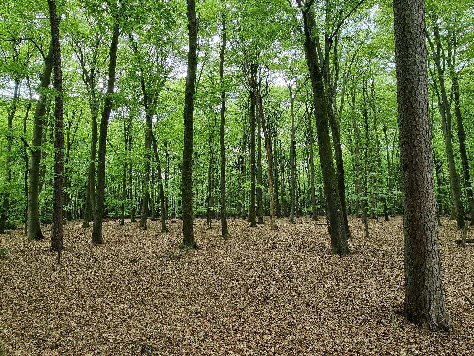
A low-angle view of a deciduous forest with tall, slender trees and a dense carpet of brown leaves on the forest floor.
A woodland scene within the Stellmoor und Weichel nature reserve, featuring a canopy of green leaves and a floor covered in dry foliage.

Stellmoor und Weichel history and protected-area timeline

The area now protected as Stellmoor und Weichel has a long history of formal landscape recognition. As early as 1938, the core of what is now the reserve was designated as a landscape protection area carrying the older name "Stellmoor." This earlier designation reflected the growing awareness, well before modern European habitat directives, that the geest woodland and associated mires in this part of the Wümme region were worth safeguarding from uncontrolled land-use change.

The character of the site changed meaningfully in 1986, when 31.6 hectares of the forest were set aside as a Naturwaldreservat, or natural forest reserve. This designation eliminated active forestry within that core, allowing woodland processes such as natural regeneration, ageing and local die-back to shape the forest on their own. The result is one of the older such reserves in Lower Saxony, valuable both for biodiversity and for long-term ecological observation.

On 1 March 2018 the area was elevated to a full nature reserve (Naturschutzgebiet) under the designation NSG WE 321, with the older 1938 landscape protection area absorbed into the new boundaries. This change brought the site firmly under the stricter protection regime that governs German nature reserves and aligned it with, or nearly aligned it with, a parallel European Fauna-Flora-Habitat (FFH) site under the EU Habitats Directive. Administrative responsibility rests with the district of Rotenburg (Wümme) as the lower nature conservation authority, while the NLWKN provides expert guidance on habitat and species management across the state's reserves.

Stellmoor und Weichel landscape and geographic character

The landscape of Stellmoor und Weichel is shaped above all by its position on the low northwestern German geest: a flat, sandy ridge that rises only modestly above the surrounding lowlands. Elevations within the reserve sit between around 22 and 32 metres above sea level, and the terrain is generally gentle, without cliffs, crags or steep valleys. Instead, the visual interest of the area comes from the transition between dry, forested sand and the wetter, lower-lying margins where the peatland begins.

Within the reserve, the dry geest ridge is cloaked in mixed woodland, dominated by oak and beech but interspersed with stands of pine, larch and spruce. Individual older trees, including a designated natural monument oak near Weichel and Eichhoop, stand out in an otherwise fairly uniform canopy. At the western edge of the protected area, the land dips into the Stellmoor depression, where the landscape changes character: pine bog woodland, peat-moss floating mats and dense willow thickets wrap around a small pond and a partially silted-up older water body. Water-management features, including ditches feeding into the Luhner Moorgraben and the surrounding canal system, are themselves part of the visible landscape and reflect the long agricultural shaping of the area.

Stellmoor und Weichel ecosystems, habitats, and plant life

The ecological character of Stellmoor und Weichel centres on the gradient between dry geest woodland and acidic bog vegetation, two habitat worlds that meet unusually closely here. On the higher, drier ground, oak–beech communities dominate the canopy, with coniferous patches of pine, larch and spruce adding structural variety. Within the forest core, a multi-decade-long period without forestry intervention has allowed natural layering, deadwood accumulation and uneven age structure to develop, all of which increase habitat complexity for woodland species.

Where the land sags and waterlogging takes over, the vegetation shifts toward classic bog communities of the North German Plain. Pine bog woodland with purple moor grass in the ground layer transitions into peat-moss-dominated floating mats, with pure willow scrub forming dense thickets around the open water. Along the slightly better-drained transition toward the adjoining Luhner Holz, sweet gale (Myrica gale, known locally as gagel) becomes conspicuous in the understorey, signalling a bog-margin woodland that is increasingly rare in intensively altered Lower Saxony. Small enclosed grassland patches, mown extensively as hay meadows, edge the forest and add a modest open-land element to an otherwise woodland-and-mire mosaic.

Stellmoor und Weichel wildlife and species highlights

The reserve's wildlife value is inseparable from its habitat mosaic. The mix of mature and naturally developing deciduous woodland, long-established natural forest reserve with accumulating deadwood, conifer stands, bog woodland, wet scrub and small open water bodies supports a range of forest, mire and wetland species typical of the northwestern German lowlands. Deadwood-rich, unmanaged stands in particular provide breeding and foraging habitat for saproxylic invertebrates, hole-nesting birds and fungi, while the bog woodland and fringes of peat-moss mats offer shelter for amphibians, dragonflies and wetland birds associated with acidic, nutrient-poor mires. Birdlife associated with old deciduous forest and bog-edge habitat can be expected throughout the year. Detailed species inventories were not strongly supported by the available source, so only the broad, well-documented habitat-based wildlife profile is presented here rather than a species-by-species claim.

Stellmoor und Weichel conservation status and protection priorities

From a conservation perspective, Stellmoor und Weichel is significant less as dramatic wilderness and more as a small but representative node in the network of protected habitats in the Wümme region. Its formal status as a nature reserve (NSG WE 321) since 2018 places it under the strictest domestic protection regime applicable to areas of this size, with the lower nature conservation authority responsible for oversight. The site is nearly coincident with a European FFH area, which embeds it directly into the EU Habitats Directive framework and obliges the protection of specific habitat types such as bog woodland and mire communities.

The 31.6-hectare natural forest reserve designated in 1986 adds further conservation weight: as one of the older such areas in Lower Saxony, it functions both as a refuge from forestry pressure and as a long-term reference for natural forest dynamics on the geest. Combined with the bog-edge communities, the sweet gale–birch–pine transitions, and the sheltered wet scrub around the Stellmoor pond, the reserve contributes to habitat continuity in a landscape otherwise heavily shaped by drainage and intensive land use. The protected status reflects both biodiversity protection and the preservation of characteristic traditional landscapes of the North German Plain.

Stellmoor und Weichel cultural meaning and human context

The defining cultural dimension of Stellmoor und Weichel is its long history as a formally recognised protected landscape rather than any specific settlement or archaeological legacy. The fact that parts of it have been under some form of official protection since 1938 gives the site nearly nine decades of continuous recognition as a landscape worth safeguarding, spanning the late Weimar and early Nazi era, the post-war Federal Republic, and the modern EU-aligned conservation regime. The designation of an individual oak as a natural monument reflects a broader northern German tradition of honouring old solitary trees within cultural landscapes. The hydrological shaping of the area, including centuries-old drainage ditches, canals and the impounding of the Stellmoor pond, is also a marker of long human interaction with the geest and its mires.

Top sights and standout views in Stellmoor und Weichel

Among the reserve's standout qualities are the long-established natural forest reserve inside its boundaries, the close juxtaposition of oak–beech geest forest with bog woodland, peat-moss floating mats and willow scrub in the Stellmoor depression, and the protected solitary oak natural monument. Its near-perfect overlap with an EU FFH area, together with the 2018 upgrade to full nature reserve status, places it firmly within both national and European conservation frameworks.

Best time to visit Stellmoor und Weichel

The reserve is a low-lying, sheltered woodland and bog landscape, so atmospheric conditions shift markedly with the seasons. Spring and early summer tend to be the most rewarding period for experiencing the bog vegetation as it greens up and for hearing breeding bird activity in the deciduous canopy, while late summer brings the visible flowering of purple moor grass and other mire species. Autumn shows the mixed forest in strong colour and is a good period for fungi and for enjoying the unmanaged natural forest reserve. Winter, although colder, reveals deadwood structure, old trees and the openness of the mire landscape more clearly under bare canopies. Visitors should keep in mind that this is a protected nature reserve with sensitive habitats rather than a recreational park, so access is best kept to existing paths and respectful of the limited infrastructure around the site.


Monthly climate preview

Long-term representative point measurements for annual temperature and precipitation patterns

Stellmoor und Weichel Climate Normals and Measured Temperature Rhythm

Stellmoor und Weichel exhibits a measured annual climate cycle spanning average winter minimums near minus nine degrees and peak summer maximums approaching twenty-nine degrees Celsius. Reviewing the complete twelve-month profile provides detailed monthly temperature distributions and precipitation averages for deeper geographic context.
Annual mean9 °C
1 °C18 °C
Jan
Feb
Mar
Apr
May13°
Jun16°
Jul18°
Aug18°
Sep14°
Oct
Nov
Dec
Warmest month
July

18.1 °C

Coolest month
January

0.7 °C

Wettest month
July

2.5 mm/day

Driest month
April

1.4 mm/day

Park location guide

Geography guide, regional context, and park location map for Stellmoor und Weichel

Stellmoor und Weichel park geography, regions, and map view in Germany

Understand where Stellmoor und Weichel sits in Germany through a broader geographic reading of the surrounding landscape, nearby location context, and its mapped position within the national park landscape.

How Stellmoor und Weichel fits into Germany

Germany is a federal republic in Western and Central Europe with a population of over 83 million across sixteen constituent states. It is Europe's largest economy by nominal GDP and a major global exporter and importer. The capital is Berlin, and the country borders Denmark, Poland, Czech Republic, Austria, Switzerland, France, Luxembourg, Belgium, and the Netherlands.

Wider geography shaping Stellmoor und Weichel in Germany

Germany is located in Western and Central Europe, spanning 357,022 km². It borders Denmark to the north, Poland and the Czech Republic to the east, Austria and Switzerland to the south, and France, Luxembourg, Belgium, and the Netherlands to the west. The country has coastlines on the Baltic Sea and North Sea to the north, with the Alps located in the southern region.

Map view of Stellmoor und Weichel

Use this park location map to pinpoint Stellmoor und Weichel in Germany, understand its exact geographic position, and read its mapped placement within the surrounding landscape more clearly.

Pigeon | © OpenStreetMap contributors

Location context for Stellmoor und Weichel

Lower Saxony
Recorded earthquake history

Browse the Historical Earthquake Catalogue for Stellmoor und Weichel

Explore the recorded seismic history surrounding Stellmoor und Weichel through our curated dataset. MoriAtlas provides historical event details including magnitude and proximity, offering a focused view of seismic activity in this region of Lower Saxony.

Stellmoor und Weichel Earthquake History

Catalogued events

2 events

Strongest magnitude

Magnitude 4.5

Most recent event

Oct 20, 2004

This history includes earthquakes recorded inside the park or within 50 km of its borders

Explore photographic records of oak and beech woodlands, peat-moss mats, and protected wetland habitats.

Stellmoor und Weichel Photos and Landscapes: Visualizing Northern German Geest and Bog Scenery

Visual documentation captures the distinct flat geest ridge and wetland transitions that define Stellmoor und Weichel. Examining these protected habitats clarifies the complex ecological interplay between ancient forests and rare mire environments.

A low-angle view of a deciduous forest with tall, slender trees and a dense carpet of brown leaves on the forest floor.

Park atlas

Discover related reserves, connected wetland habitats, and surrounding northern German landscapes.

Explore Protected Areas and Parks Near Stellmoor und Weichel for Regional Comparison

Compare Stellmoor und Weichel with other protected areas across the surrounding region to analyze regional park geography and habitat transitions. Continuing into adjacent reserves reveals broader ecological patterns among local geest forests and wetland complexes.
Nature reserveLandkreis Rotenburg (Wümme)
0.9 km away#1 closest

East

Wümmeniederung mit Rodau, Wiedau und Trochelbach: Protected Wetland and Heath Landscape

Regional geography and floodplain connectivity in Landkreis Rotenburg

This nature reserve protects a sprawling lowland landscape characterized by the Wümme, Rodau, Wiedau, and Trochelbach rivers. The terrain features a mosaic of near-natural meandering streams, species-rich wet meadows, and rare raised bog remnants, providing a comprehensive overview of northern German lowland ecology.

Area
28.96 km²
Established
2020
IUCN
IV
Relief
Lowland
Nature reserveLandkreis Rotenburg (Wümme)
About 4.8 km away#2 closest

Northwest

Westliches Borchelsmoor Nature Reserve: Geographic Profile and Protected Bog Landscape

A preserved peatland fragment in the Landkreis Rotenburg district.

Located in northern Lower Saxony, Westliches Borchelsmoor represents a significant remnant of the historical Borchelsmoor raised bog. The reserve showcases a complex topography of old drainage lines and birch woodland, providing a clear window into the ecological transition of modified moorland. This site serves as a core component of the local wetland mosaic and offers valuable insights into ongoing peatland restoration and bog conservation.

Area
1.25 km²
Established
2010
IUCN
IV
Relief
Lowland
Nature reserveLower Saxony
About 8.2 km away#3 closest

West

Wiestetal Nature Reserve: Mapping the Wieste Stream and Riparian Habitat Corridor

Protected floodplain geography in Lower Saxony, Germany

Wiestetal acts as a critical nature reserve between Mulmshorn and Ottersberg, protecting the unique ecological character of the Wieste lowland stream. The area is defined by its meandering water channels, flooded sand quarry ponds, and diverse forest edges that sustain local biodiversity. This protected landscape offers a detailed look at the interplay between glacial sand deposits and the vibrant aquatic ecosystems of Northern Germany.

Area
3.82 km²
Established
2013
IUCN
IV
Relief
Upland
Nature reserveLower Saxony
12 km away#4 closest

South

Wolfsgrund Nature Reserve: Geographic Overview of Protected Heathlands in Lower Saxony

Inland dune topography and alder swamp forest ecology

Wolfsgrund represents a core protected area in Lower Saxony, defined by its unique inland dune geography and the narrow valley of the Everser Bach. The reserve encompasses a diverse ecological gradient, protecting sensitive dry heath, moist heathlands, and alder swamp forests that serve as a crucial refuge for regional biodiversity. This structured geographic overview highlights the terrain transitions and conservation significance of this essential German nature reserve.

Area
0.458 km²
Established
1977
IUCN
IV
Nature reserveLower Saxony
13 km away#5 closest

South

Wedeholz Nature Reserve: Geographic Overview of Lower Saxony Protected Forest Landscapes

Ancient oak forests, Geest terrain, and protected wetland habitats

Wedeholz represents a dense forest conservation area in Lower Saxony, defined by its mature oak and beech communities. The reserve terrain transitions from dry sandy Geest soils to delicate pine swamp forests and floating bogs, supporting a high density of deadwood-dependent species and woodland biodiversity within a compact, protected boundary.

Area
1.83 km²
Established
2019
IUCN
IV
Relief
Upland
Nature reserveLower Saxony
About 15 km away#6 closest

Southwest

Waller Moor Nature Reserve: Geographic Context and Protected Landscape Profile

Mapping raised bog restoration in the Verden district of Lower Saxony

Waller Moor represents a focused effort to restore degraded peatland within Lower Saxony. By integrating grassland buffers and small pond habitats, the reserve preserves a specific lowland bog character. Its placement near the Spanger Holz woodland highlights the interplay between protected core habitats and managed regional terrain in northern Germany.

Area
0.25 km²
Established
1985
IUCN
IV
Relief
Lowland
Nature reserveNiedersachsen
About 18 km away#7 closest

Southwest

Waller Flachteiche Nature Reserve: Exploring the Geography of Protected Landscapes in Niedersachsen

Mapped habitats of a former sand quarry wetland

Waller Flachteiche is a state-recognized nature reserve covering over 22 hectares of sandy, lowland terrain in Germany. The protected area offers a look at a recovered industrial site, where periodically drying ponds and diverse scrubland create a specialized habitat for rare amphibians and wetland flora. Its defined boundaries highlight a critical Natura 2000 component within the broader Niedersachsen region.

Area
0.227 km²
Established
2018
IUCN
IV
Nature reserveLower Saxony
About 24 km away#8 closest

South

Verdener Moor Nature Reserve: Geographic Atlas and Protected Area Context

Preserving raised bog ecosystems in Lower Saxony, Germany

Located in the municipality of Kirchlinteln, Verdener Moor functions as a protected nature reserve that demonstrates lowland peatland conservation. The landscape features a distinct mosaic of open water resulting from historical peat extraction, wet heath, and rewilded forest edges. This site offers valuable insight into the restoration of bog habitats through rewetting and bush removal within the broader geography of Lower Saxony.

Area
0.91 km²
Established
1989
IUCN
IV
Relief
Lowland

Common questions about visiting, size, designation, and location context for Stellmoor und Weichel

Stellmoor und Weichel FAQs for park facts, access, geography, and protected area context

Find quick answers about Stellmoor und Weichel, including protected-area facts, park geography, trail and visitor context, and how the park fits into its surrounding country and regional landscape.
MoriAtlas Explorer

Continue Your Protected Areas Search Across the Global Atlas

Deepen your exploration by continuing the structured search for national parks and protected areas worldwide. Utilize the comprehensive filtering capabilities to compare different conservation landscapes and refine your understanding of global park geography. Discover more about the distribution and characteristics of protected natural areas.

Global natural geography