
Mori Atlas logo
Nature reserveWümmeniederung mit Rodau, Wiedau und Trochelbach

Analyzing the interconnected river corridors, bog remnants, and dry heath habitats of Lower Saxony

Wümmeniederung mit Rodau, Wiedau und Trochelbach: A Detailed Geographic Protected Area Study

(Naturschutzgebiet Wümmeniederung mit Rodau, Wiedau und Trochelbach (NSG LÜ 355))

The Wümmeniederung mit Rodau, Wiedau und Trochelbach represents a significant nature reserve in northern Lower Saxony, Germany. This protected landscape encompasses extensive floodplain river systems, near-natural meandering channels, and complex bog woodlands. It serves as a vital corridor for diverse wetland habitats, ranging from wet meadows to rare dry inland dunes and juniper heaths within the Landkreis Rotenburg region.

floodplainlowland riverwet meadowsraised bogbog woodlandinland dunes
Stylized vector illustration showing a river flowing through a coniferous forest toward a waterfall cascading down a mountain face under a bright sun.

Wümmeniederung mit Rodau, Wiedau und Trochelbach

Nature reserve

Park overview

Structured park overview, official facts, and landscape profile for Wümmeniederung mit Rodau, Wiedau und Trochelbach

Wümmeniederung mit Rodau, Wiedau und Trochelbach park facts, protected area profile, and essential visitor context

Review the core facts for Wümmeniederung mit Rodau, Wiedau und Trochelbach, including designation, size, terrain, visitor scale, habitats, and operating context in one park-focused overview.

About Wümmeniederung mit Rodau, Wiedau und Trochelbach

Wümmeniederung mit Rodau, Wiedau und Trochelbach lies in the heart of the Landkreis Rotenburg (Wümme), in the northern German state of Lower Saxony. Its roughly 2,900 hectares follow the course of the River Wümme from Scheeßel through Rotenburg and beyond, while also embracing the floodplains of the smaller Rodau, Wiedau and Trochelbach streams that join the Wümme as tributaries.

The defining feature of the reserve is a connected mosaic of habitats rather than any single landscape. The rivers and brooks run in broadly natural, meandering courses through their floodplains, with old oxbow channels still preserved in places. Around them lies a varied patchwork of meadows and pastures of different moisture levels, including small stands of mat-grass and purple moor-grass communities that are now rare in intensively farmed northwest German lowlands. These open wet habitats are framed by floodplain forests of black alder, ash, elm, oak and hornbeam, as well as older mixed oak-birch and oak-hornbeam stands with notably high amounts of dead and decaying wood.

Where the Wümme cuts through wetter ground in its upper sections, fragments of raised bog, transitional mire and floating peat mats survive, colonised by bog birch, silver birch and Scots pine around bog woodland pools. By contrast, the edges of the floodplain carry inland sand dunes and valley slopes supporting dry heath, broom and juniper communities, silver-grass stands and small patches of calcareous and species-rich dry grassland. This juxtaposition of bog, marsh, river woodland, dune and heath within a protected floodplain corridor gives the reserve its particular character.

Beyond its habitat diversity, the area harbours a rich fauna typical of well-preserved lowland river landscapes. The rivers shelter species such as eel, pike, sea trout, bullhead, minnow, bitterling, weatherfish, stone loach and the three European lampreys, while beavers and otters again use the wider Wümme corridor. The standing waters, moors and forests together support numerous amphibians, dragonflies, reptiles and bats, and the bird life is exceptionally diverse, including species associated with extensive wet meadows, open bogs and old broadleaf woodland.

Quick facts and research context for Wümmeniederung mit Rodau, Wiedau und Trochelbach

Wümmeniederung mit Rodau, Wiedau und Trochelbach is a nature reserve (Naturschutzgebiet) covering roughly 2,896 hectares in the Landkreis Rotenburg (Wümme), Lower Saxony. It carries the official code NSG LÜ 355 and was placed under protection on 1 August 2020, administered by the Landkreis Rotenburg (Wümme) with oversight from the Niedersächsischer Landesbetrieb für Wasserwirtschaft, Küsten- und Naturschutz (NLWKN). The reserve is largely coextensive with the FFH (Habitats Directive) site Wümmeniederung, and a small southern portion lies within the EU Birds Directive site Moore bei Sittensen. It represents the lower Wümme floodplain system, including tributaries and associated bog, heath, dune and forest habitats, and is IUCN Category IV (Habitat/Species Management Area).

Protection and recognition

Documented terrestrial protection scope and official designation records

Wümmeniederung mit Rodau, Wiedau und Trochelbach Protection Status and Recognition

Wümmeniederung mit Rodau, Wiedau und Trochelbach features recorded terrestrial protection status within the global protected area registry. Structured designation records outline the management framework and administrative details for this conservation landscape.

Protection details

Protection scope
Terrestrial
Transboundary protection
No
WDPA ID
555632794
Park context

Deeper park guide and search-rich context for Wümmeniederung mit Rodau, Wiedau und Trochelbach

Wümmeniederung mit Rodau, Wiedau und Trochelbach history, landscape, wildlife, and travel context

Explore Wümmeniederung mit Rodau, Wiedau und Trochelbach through its history, landscape character, ecosystems, wildlife, conservation priorities, cultural context, and seasonal travel timing in a structured park guide built for atlas discovery and search intent.

Why Wümmeniederung mit Rodau, Wiedau und Trochelbach stands out

The reserve is best known for its long, near-natural meandering sections of the Wümme and its tributaries, interspersed with species-rich wet meadows, fens and reedbeds. Equally distinctive are the relict raised bogs, transitional mires and bog woodlands with birch and Scots pine in the upper Wümme valley. Sand dunes, juniper heaths and dry grassland fringe the floodplain, giving the reserve a rare combination of wet and dry lowland habitats within a single protected area.
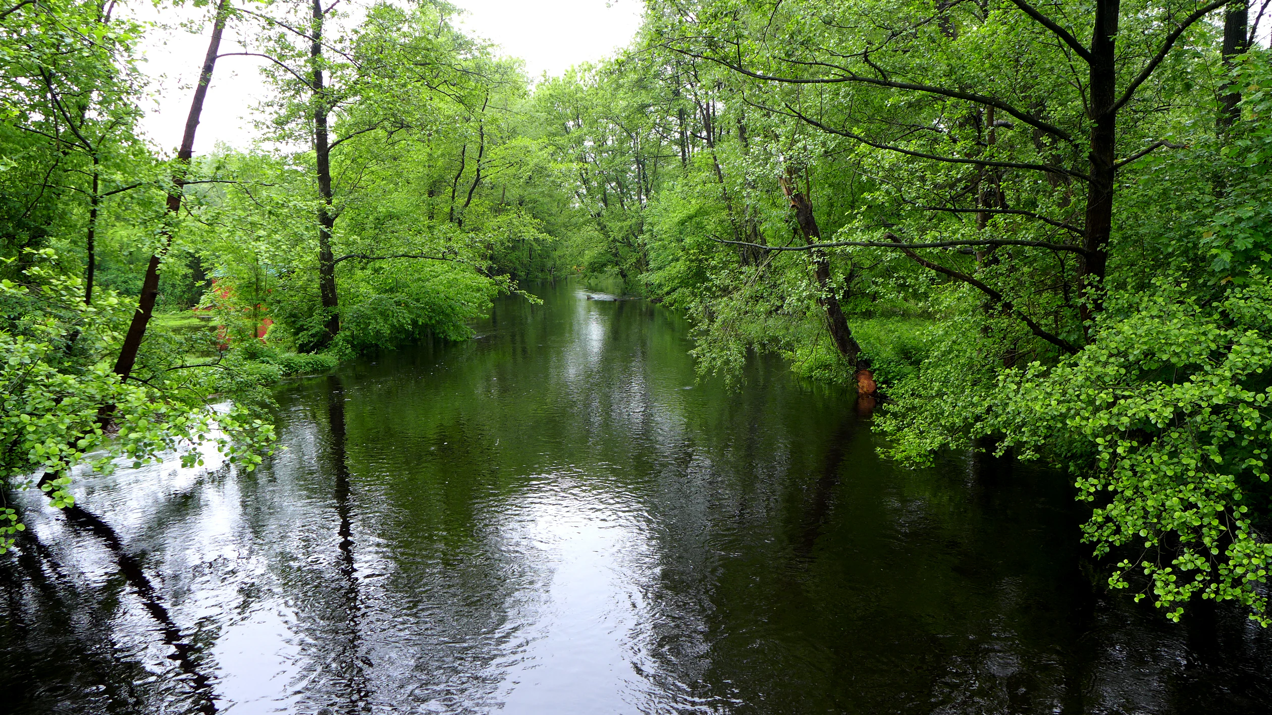
A peaceful river flows through a dense forest with lush green trees overhanging the banks.
The Wümme river flowing through a lush, forested section of the Wümmeniederung nature reserve.

Wümmeniederung mit Rodau, Wiedau und Trochelbach history and protected-area timeline

The contemporary Wümmeniederung mit Rodau, Wiedau und Trochelbach reserve is the product of a long process of consolidating earlier, smaller protected areas in the Wümme floodplain. It was formally established on 1 August 2020 under the designation NSG LÜ 355, bringing together the former nature reserves Ekelmoor, Fährhof and Voßberge, as well as large parts of the landscape protection areas Obere Wümmeniederung and Wümmeniederung unterhalb Rotenburg, plus the Vareler Wacholdergebiet, the Untere Rodau- und Wiedauniederung and the Hastedter Wacholder- und Stechginstergebiet. Portions of the older landscape protection areas Hastedter Schnuckenheide and Dünenlandschaft am Wehrmeistersee were also absorbed.

The new reserve was created to give cohesive protection to the Wümme floodplain system and its tributaries, much of which was already recognised at the European level. The great majority of its area lies within the FFH (Habitats Directive) site Wümmeniederung, and a small southern section belongs to the EU Birds Directive site Moore bei Sittensen, embedding the reserve in the wider Natura 2000 network. Administration is shared between the Landkreis Rotenburg (Wümme) as the lower nature conservation authority and the Niedersächsischer Landesbetrieb für Wasserwirtschaft, Küsten- und Naturschutz (NLWKN) at the state level.

Wümmeniederung mit Rodau, Wiedau und Trochelbach landscape and geographic character

The landscape of the reserve is shaped by the slow, meandering lowland rivers that cut through a broad sandy valley. Over most of their length, the Wümme, Rodau, Wiedau and Trochelbach flow in near-natural channels, with old meander loops and oxbow waters still visible along the floodplain. Their banks are lined with reedbeds, sedge beds and tall herb communities, while strips of trees border the Wümme over long stretches. The Scheeßeler Mühle weir marks one of the few interruptions to the otherwise intact hydrological connectivity of the Wümme within the protected area.

Beyond the wet river corridor, the terrain alternates between flat, often waterlogged floodplain meadows and gently rising, drier land. In the upper reaches of the Wümme, the river passes through open bog and bog woodland, an unusually well-preserved feature in this part of Lower Saxony. Along the edges of the valley and on inland sand dunes, the ground becomes markedly drier, supporting juniper heath, heather and grass-rich dry grassland stands perched above the floodplain.

Wümmeniederung mit Rodau, Wiedau und Trochelbach ecosystems, habitats, and plant life

Ecologically, the reserve functions as a large, connected lowland river system in which truly aquatic, wet, boggy and dry habitats all occur in close proximity. The watercourses carry submerged aquatic vegetation, while the floodplain hosts a gradient of grasslands from damp meadows to drier pasture, including communities of mat-grass and purple moor-grass that depend on traditional, low-intensity use. Reedbeds, sedges and tall herb fringes line the channels, and small still waters such as ponds and moor pools add further structural diversity.

The wooded element of the reserve is unusually rich. Along the Wümme, gallery-like floodplain forests of alder, ash and elm grow alongside more extensive oak, oak-hornbeam and beech-mixed forests. Many of these stands contain significant amounts of old and dead wood, supporting saproxylic invertebrates, woodpeckers and forest bats. The bog sections add a very different set of woodland communities dominated by birch and Scots pine, while the dunes support low juniper and heather vegetation with patches of lichen-rich dry grassland. Together these habitats give the reserve a layered ecological structure unusual for the region.

Wümmeniederung mit Rodau, Wiedau und Trochelbach wildlife and species highlights

The reserve hosts an unusually complete set of species associated with lowland river landscapes. The Wümme and its tributaries provide habitat for fish such as eel, pike, sea trout, bullhead, minnow, bitterling, weatherfish and stone loach, and the three European lampreys, while the larger mammals beaver and otter use the river corridor with its quiet backwaters and dense bank vegetation. Dragonflies are exceptionally well represented, including the green river hawker, green mosaic hawker and delicate whiteface in flowing waters, and the large whiteface in the bog pools.

Bats thrive in the combination of old woodland, barns and water, with species such as greater mouse-eared bat, Bechstein's bat, both barbastelles, serotine, common and soprano noctules, Nathusius's pipistrelle, common pipistrelle, Daubenton's bat and pond bat recorded. Amphibians find breeding sites in the still waters and bog pools, including moor frog and garlic toad. Reptiles such as the smooth snake occur on the dry dunes and heaths.

The bird life is one of the reserve's strongest features. Breeding and visiting birds include crane, black stork, eagle owl, hobby, red kite, cuckoo, lapwing, snipe, green sandpiper, nightjar, black woodpecker, middle spotted woodpecker and great spotted woodpecker, as well as red-backed shrike, golden oriole, common redstart, woodlark, whinchat, common stonechat, bluethroat, marsh warbler and grasshopper warbler. Ducks such as Eurasian teal, garganey and gadwall use the wet habitats, while migrating and wintering visitors include little ringed plover, greenshank, woodcock, great grey shrike, greylag goose and tufted duck.

Wümmeniederung mit Rodau, Wiedau und Trochelbach conservation status and protection priorities

The reserve's conservation significance lies in its scale and ecological coherence. By joining several older protected areas, it safeguards a long, functioning stretch of the Wümme and its tributary floodplains, with their full sequence of wet meadows, mires, bog woodlands, floodplain forests and dry heaths. Most of the area is part of the EU Natura 2000 network through the FFH site Wümmeniederung, and a smaller southern part falls within the Birds Directive site Moore bei Sittensen, anchoring it within European habitat and species protection frameworks.

The designation as a Naturschutzgebiet under the German Federal Nature Conservation Act gives the area a strong legal protection status. Management, overseen by the Landkreis Rotenburg (Wümme) and supported by the NLWKN, focuses on preserving the hydrological and hydrochemical conditions of the streams, mires and floodplain grasslands, maintaining near-natural river dynamics, retaining substantial deadwood in the deciduous and bog forests, and sustaining the open heath and dune communities through appropriate grazing and disturbance regimes.

Wümmeniederung mit Rodau, Wiedau und Trochelbach cultural meaning and human context

The Wümme valley carries cultural layers typical of the north-west German lowlands. The river itself and its tributaries historically drove water mills such as the Scheeßeler Mühle, and the floodplain meadows and heaths reflect long traditions of grazing with sheep and cattle, including the regional Heidschnucke sheep associated with the Lüneburg Heath culture that surrounds the area. Juniper heath, broom heaths and sheep-grazed dry grassland within the reserve are heirs to those centuries-old land uses, and the Nordpfade long-distance walking routes now follow historical paths through this working cultural landscape.

Top sights and standout views in Wümmeniederung mit Rodau, Wiedau und Trochelbach

Wümmeniederung mit Rodau, Wiedau und Trochelbach brings together four interconnected strengths: near-natural meandering rivers with associated floodplain meadows; extensive bog and bog woodland remnants in the upper Wümme valley; large, structurally rich floodplain and oak-hornbeam forests with abundant deadwood; and dry inland dune and juniper heath communities on the valley margins. The combination of habitats supports a strikingly diverse fauna, from lampreys and otters in the rivers, through rare dragonflies and amphibians in the bogs, to a rich forest and meadow bird community that includes crane, black stork, black woodpecker and eagle owl.

Best time to visit Wümmeniederung mit Rodau, Wiedau und Trochelbach

Late spring and early summer are generally the most rewarding period, when wet meadows, fens and heaths are in full bloom and woodland birds are actively singing. Early mornings at this time of year offer the best chance to encounter secretive species such as nightjar, woodlark and crakes along the valley edges. Autumn brings its own appeal with migrating cranes overhead, while winter can offer quiet views of the open floodplain and large numbers of waterfowl on remaining wet areas, though some paths may be wet underfoot.

Monthly climate preview

Long-term representative temperature and precipitation averages across twelve distinct monthly cycles

Wümmeniederung mit Rodau, Wiedau und Trochelbach Climate Normals and Annual Weather Patterns

Representative coordinates record distinct annual temperature swings alongside steady daily precipitation rates across the measured multi-year climatology period. Detailed monthly comparisons reveal complete seasonal rhythms and baseline meteorological norms for the protected river landscapes.
Annual mean9 °C
1 °C18 °C
Jan
Feb
Mar
Apr
May13°
Jun16°
Jul18°
Aug18°
Sep14°
Oct
Nov
Dec
Warmest month
July

18.1 °C

Coolest month
January

0.7 °C

Wettest month
July

2.5 mm/day

Driest month
April

1.4 mm/day

Park location guide

Geography guide, regional context, and park location map for Wümmeniederung mit Rodau, Wiedau und Trochelbach

Wümmeniederung mit Rodau, Wiedau und Trochelbach park geography, regions, and map view in Germany

Understand where Wümmeniederung mit Rodau, Wiedau und Trochelbach sits in Germany through a broader geographic reading of the surrounding landscape, nearby location context, and its mapped position within the national park landscape.

How Wümmeniederung mit Rodau, Wiedau und Trochelbach fits into Germany

Germany is a federal republic in Western and Central Europe with a population of over 83 million across sixteen constituent states. It is Europe's largest economy by nominal GDP and a major global exporter and importer. The capital is Berlin, and the country borders Denmark, Poland, Czech Republic, Austria, Switzerland, France, Luxembourg, Belgium, and the Netherlands.

Wider geography shaping Wümmeniederung mit Rodau, Wiedau und Trochelbach in Germany

Germany is located in Western and Central Europe, spanning 357,022 km². It borders Denmark to the north, Poland and the Czech Republic to the east, Austria and Switzerland to the south, and France, Luxembourg, Belgium, and the Netherlands to the west. The country has coastlines on the Baltic Sea and North Sea to the north, with the Alps located in the southern region.

Map view of Wümmeniederung mit Rodau, Wiedau und Trochelbach

Use this park location map to pinpoint Wümmeniederung mit Rodau, Wiedau und Trochelbach in Germany, understand its exact geographic position, and read its mapped placement within the surrounding landscape more clearly.

Pigeon | © OpenStreetMap contributors

Location context for Wümmeniederung mit Rodau, Wiedau und Trochelbach

Landkreis Rotenburg (Wümme)Lower Saxony
Recorded earthquake history

View Recorded Seismic Activity for Wümmeniederung mit Rodau, Wiedau und Trochelbach

Review documented historical earthquakes mapped in the vicinity of Wümmeniederung mit Rodau, Wiedau und Trochelbach. This collection tracks seismic records by epicentre proximity to the reserve, providing a clear window into regional geological history as catalogued by external sources.

Wümmeniederung Earthquake History

Catalogued events

3 events

Strongest magnitude

Magnitude 4.5

Most recent event

Jul 15, 2005

This history includes earthquakes recorded inside the park or within 50 km of its borders

Visualizing meandering lowland rivers, relict raised bogs, and floodplain habitats in Lower Saxony

Wümmeniederung mit Rodau, Wiedau und Trochelbach Landscape Photography and Protected Area Scenery

Photographic documentation reveals the intricate topography of meandering river corridors, wet meadows, and dry juniper heaths across Wümmeniederung mit Rodau, Wiedau und Trochelbach. Visual records provide essential context for understanding the complex lowland habitats and protected ecosystem character.

A peaceful river flows through a dense forest with lush green trees overhanging the banks.

A peaceful river flows through a lush, green riparian forest, with trees overhanging the water and sunlight reflecting off the surface.

Park atlas

Compare nearby lowland river corridors, floodplain forests, and regional nature reserves

Parks Near Wümmeniederung mit Rodau, Wiedau und Trochelbach and Regional Protected Landscapes

Continue exploring protected areas near Wümmeniederung mit Rodau, Wiedau und Trochelbach by browsing adjacent lowland river valleys, wetlands, and woodland habitats. Comparing these surrounding reserves reveals broader regional ecological patterns and connected conservation landscapes.
Nature reserveLower Saxony
0.9 km away#1 closest

West

Stellmoor und Weichel: Geographic Profile of a Lower Saxony Nature Reserve

Protected geest woodlands and peat-bog mosaic landscapes

Examine the territorial boundaries and ecological features of Stellmoor und Weichel. Located on the flat geest ridge of Northern Germany, this reserve maps the transition from managed deciduous woodland to complex mire, willow thicket, and bog-fringe water systems, maintaining a long-standing natural forest reserve status.

Area
2.18 km²
Established
2018
IUCN
IV
Nature reserveLower Saxony
About 5.4 km away#2 closest

Southwest

Waller Moor Nature Reserve: Geographic Context and Protected Landscape Profile

Mapping raised bog restoration in the Verden district of Lower Saxony

Waller Moor represents a focused effort to restore degraded peatland within Lower Saxony. By integrating grassland buffers and small pond habitats, the reserve preserves a specific lowland bog character. Its placement near the Spanger Holz woodland highlights the interplay between protected core habitats and managed regional terrain in northern Germany.

Area
0.25 km²
Established
1985
IUCN
IV
Relief
Lowland
Nature reserveLower Saxony
6.2 km away#3 closest

Southwest

Wolfsgrund Nature Reserve: Geographic Overview of Protected Heathlands in Lower Saxony

Inland dune topography and alder swamp forest ecology

Wolfsgrund represents a core protected area in Lower Saxony, defined by its unique inland dune geography and the narrow valley of the Everser Bach. The reserve encompasses a diverse ecological gradient, protecting sensitive dry heath, moist heathlands, and alder swamp forests that serve as a crucial refuge for regional biodiversity. This structured geographic overview highlights the terrain transitions and conservation significance of this essential German nature reserve.

Area
0.458 km²
Established
1977
IUCN
IV
Nature reserveLower Saxony
About 7.2 km away#4 closest

West

Wiestetal Nature Reserve: Mapping the Wieste Stream and Riparian Habitat Corridor

Protected floodplain geography in Lower Saxony, Germany

Wiestetal acts as a critical nature reserve between Mulmshorn and Ottersberg, protecting the unique ecological character of the Wieste lowland stream. The area is defined by its meandering water channels, flooded sand quarry ponds, and diverse forest edges that sustain local biodiversity. This protected landscape offers a detailed look at the interplay between glacial sand deposits and the vibrant aquatic ecosystems of Northern Germany.

Area
3.82 km²
Established
2013
IUCN
IV
Relief
Upland
Nature reserveLower Saxony
7.8 km away#5 closest

Southwest

Wedeholz Nature Reserve: Geographic Overview of Lower Saxony Protected Forest Landscapes

Ancient oak forests, Geest terrain, and protected wetland habitats

Wedeholz represents a dense forest conservation area in Lower Saxony, defined by its mature oak and beech communities. The reserve terrain transitions from dry sandy Geest soils to delicate pine swamp forests and floating bogs, supporting a high density of deadwood-dependent species and woodland biodiversity within a compact, protected boundary.

Area
1.83 km²
Established
2019
IUCN
IV
Relief
Upland
Nature reserveLandkreis Rotenburg (Wümme)
About 7.8 km away#6 closest

Northwest

Westliches Borchelsmoor Nature Reserve: Geographic Profile and Protected Bog Landscape

A preserved peatland fragment in the Landkreis Rotenburg district.

Located in northern Lower Saxony, Westliches Borchelsmoor represents a significant remnant of the historical Borchelsmoor raised bog. The reserve showcases a complex topography of old drainage lines and birch woodland, providing a clear window into the ecological transition of modified moorland. This site serves as a core component of the local wetland mosaic and offers valuable insights into ongoing peatland restoration and bog conservation.

Area
1.25 km²
Established
2010
IUCN
IV
Relief
Lowland
Nature reserveNiedersachsen
About 11 km away#7 closest

Southwest

Waller Flachteiche Nature Reserve: Exploring the Geography of Protected Landscapes in Niedersachsen

Mapped habitats of a former sand quarry wetland

Waller Flachteiche is a state-recognized nature reserve covering over 22 hectares of sandy, lowland terrain in Germany. The protected area offers a look at a recovered industrial site, where periodically drying ponds and diverse scrubland create a specialized habitat for rare amphibians and wetland flora. Its defined boundaries highlight a critical Natura 2000 component within the broader Niedersachsen region.

Area
0.227 km²
Established
2018
IUCN
IV
A pale, soft-toned watercolor illustration of a calm river meandering through open, green marshy meadows with distant rolling hills under a soft pink sky.
Nature reserveBremen
12 km away#8 closest

West

Borgfelder Wümmewiesen: Protected Wetland and Floodplain Geography in Bremen

An expansive 688-hectare nature reserve with river-fed grasslands.

Borgfelder Wümmewiesen offers a look at one of the largest protected nature reserves in the Bremen region. The landscape is characterized by its flat, open terrain and regular water dynamics that frame a rich mosaic of wet meadows, reedbeds, and ponds, providing essential habitat for breeding and migratory bird species along the Wümme river corridor.

Area
6.88 km²
Established
1987
Relief
Lowland
Climate
Temperate

Common questions about visiting, size, designation, and location context for Wümmeniederung mit Rodau, Wiedau und Trochelbach

Wümmeniederung mit Rodau, Wiedau und Trochelbach FAQs for park facts, access, geography, and protected area context

Find quick answers about Wümmeniederung mit Rodau, Wiedau und Trochelbach, including protected-area facts, park geography, trail and visitor context, and how the park fits into its surrounding country and regional landscape.
MoriAtlas Explorer

Continue Your Protected Areas Search Across the Global Atlas

Deepen your exploration by continuing the structured search for national parks and protected areas worldwide. Utilize the comprehensive filtering capabilities to compare different conservation landscapes and refine your understanding of global park geography. Discover more about the distribution and characteristics of protected natural areas.

Global natural geography