
Why Tagebau Haverlahwiese stands out
Tagebau Haverlahwiese is best known as a striking example of how a disused ironstone open-pit mine can be transformed into a high-value habitat complex. Its combination of a former mining lake, terraced spoil heaps, amphibian-rich ponds, dry calcareous grassland, and a rare secondary inland saline spot makes it ecologically distinctive within the Salzgitter hill country. The reserve also stands out for being one of the few protected areas in the region explicitly designated around northern crested newt (Kammmolch) habitat, with the FFH designation anchoring the site's identity around this species.
Tagebau Haverlahwiese history and protected-area timeline
The landscape now protected as Tagebau Haverlahwiese was shaped by industrial mining rather than by deliberate conservation planning. Ironstone was extracted here as an open-pit mine from 1937 to 1967 as part of the broader Grube Haverlahwiese operation. When extraction ended, the site did not immediately return to nature; instead, the pit floor, terraced slopes, and spoil heaps entered a long reclamation phase that continued into the 1980s.
In 1999, an area of about 85 hectares in the northwestern part of the current reserve was designated as the landscape protection area Haverlahwiese, marking the first formal recognition of the site's emerging ecological value. This designation was later absorbed into the larger nature reserve when the present-day Naturschutzgebiet was established on 30 June 2016 under the code NSG BR 149. The 2016 designation also formalized the protection status of the FFH site Kammmolch-Biotop Tagebau Haverlahwiese, which had previously been recognized at the European level for its crested newt habitat. Today the land remains in public ownership, held by the Federal Republic of Germany and the State of Lower Saxony, and is managed by the city of Salzgitter as the lower nature conservation authority.
Tagebau Haverlahwiese landscape and geographic character
The reserve occupies the southwestern flank of the Lichtenberge, which form the southernmost reach of the Salzgitter ridge (Salzgitterscher Höhenzug). To the south and west the protected area is bordered by a ridge connecting Sieben Köpfe, Gustedter Berg, and Elber Berg, giving the site a defined position within a broader chain of low hills. Elevation within the reserve runs from about 165 meters in the lower areas up to roughly 240 meters on the surrounding slopes.
The most prominent macro-scale features are the pit floor of the former open-pit mine, the roughly 15-hectare Tagebausee (mining lake) in the northwestern section, and the terraced spoil heaps that ring parts of the old workings. An elongated spoil ridge made of material from the Konrad shaft system runs across the reserve, dividing the southeastern open-land section in two. The haul road to the former Haverlahwiese I shaft and the substation in the northeast remain visible functional elements, even though those narrow zones are excluded from the protected-area boundary.
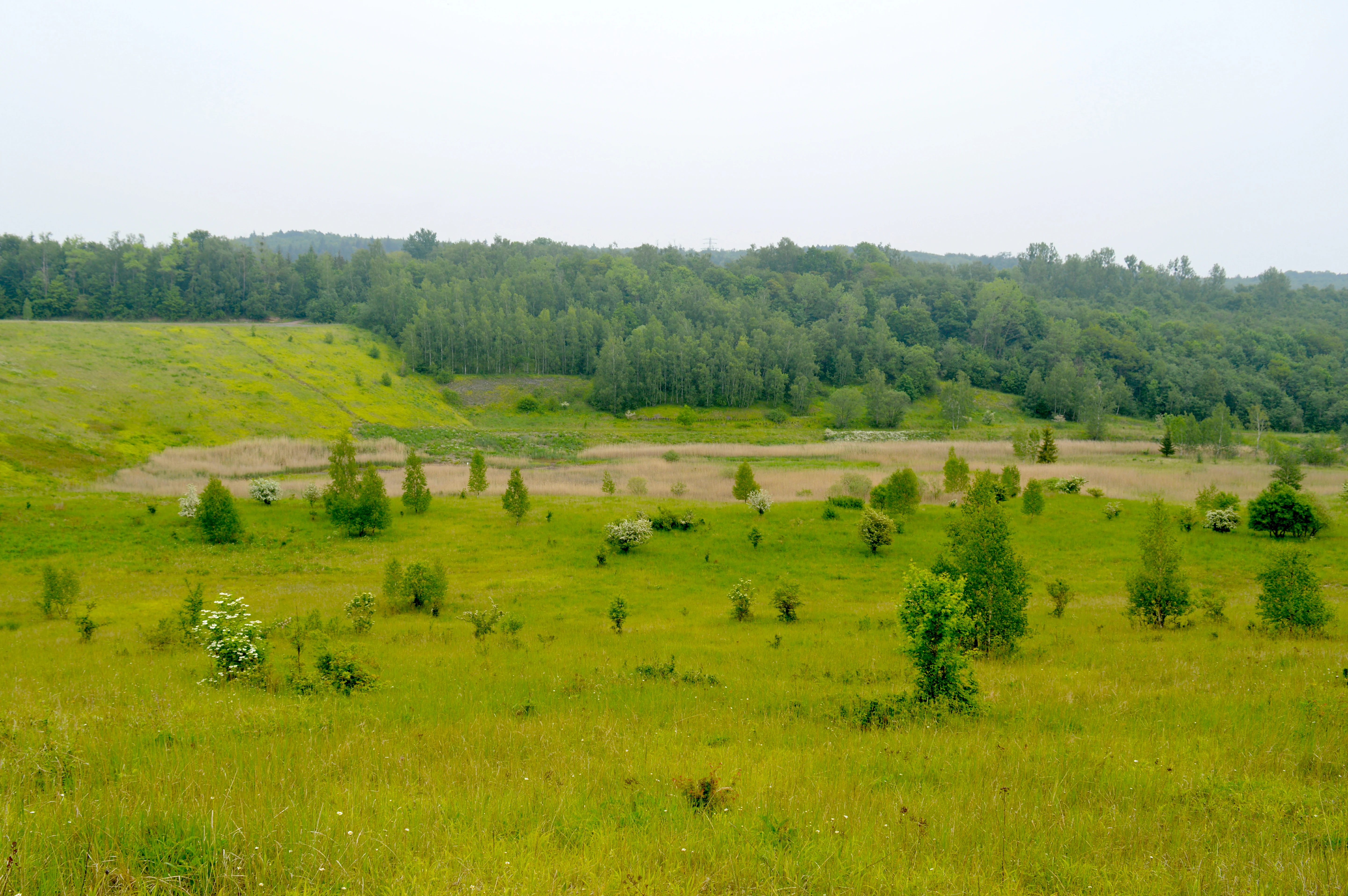
Beyond these engineered landforms, the landscape is shaped by gentle stream channels and spring zones. The Oelber Bach grazes the northern edge of the reserve. Where mining ceased and water collected, natural and artificially created ponds, shallow pools, and reedbeds have come to occupy the lower contours, while the higher, drier terraces still carry spoil heaps with raw soil patches and remnant calcareous grassland.
Tagebau Haverlahwiese ecosystems, habitats, and plant life
Ecologically, Tagebau Haverlahwiese is built on a deliberate mix of dry and wet habitats set on post-mining substrate. The southeastern part of the reserve is defined by open biotopes: sparsely vegetated areas of the former pit floor, raw-soil patches on terraced spoil heaps, shallow man-made and natural pools along the pit floor, and small reedbeds in the wettest corners. This part of the reserve has a pioneer character, with bare ground and low vegetation still dominant in many places.
The northwestern section hosts the Tagebausee and a mosaic of habitats around it, including a roughly 15-hectare mining lake, pioneer woodland, dry calcareous grasslands, orchid-rich areas, and tall-herb and grass communities. Aquatic vegetation in the lake includes species such as the common water crowfoot (Wasserhahnenfuß), and the shoreline is lined with bulrush, reedmace, and common reed communities. Stream fragments and spring zones, including those associated with the Oelber Bach on the northern edge, add small but ecologically important freshwater features.
A remarkable feature of the reserve is a secondary inland saline spot (Binnensalzstelle) that has developed at the base of one of the spoil heaps, where salt-tolerant and salt-loving plants such as common salt-grass (Gewöhnlicher Salzschwaden) and salt sandspurry (Salzschuppenmiere) have established themselves. The small water bodies at the foot of the same heap are themselves noticeably saline. In addition, an old limestone quarry within the reserve and other shallow, base-rich slopes of the former pit support dry calcareous grasslands with characteristic species such as the fringed gentian (Fransenenzian). On the slopes of the old pit rim, mixed deciduous woodland has taken hold, closing the habitat mosaic around a complete gradient from dry, open, calcareous and saline ground to wet pond and reed habitats, and finally to shaded forest.
Tagebau Haverlahwiese wildlife and species highlights
The reserve's mosaic of water bodies, open land, and forest margins produces a diverse, amphibian-rich fauna. The northern crested newt (Kammmolch) is the species most closely associated with the site, and the FFH designation explicitly centers on this animal. The reserve also supports at least eight additional amphibian species, including natterjack toad (Wechselkröte) and common toad (Kreuzkröte), although the natterjack toad was last confirmed at the site in 2004 and may no longer maintain a breeding population there.
Reptile presence is comparatively modest but includes the common lizard (Waldeidechse) and slow worm (Blindschleiche), both of which find the dry, sun-exposed terrain around the spoil heaps suitable. The open-land areas, especially on the Abraumhalde, host characteristic dry-ground invertebrates, including the blue-winged grasshopper (Blauflügelige Sandschrecke) and the blue-winged locust (Blauflügelige Ödlandschrecke). The ponds and the mining lake support varied dragonfly (Libelle) communities, and butterflies such as the swallowtail (Schwalbenschwanz) and the Bath white (Resedafalter) occur, sometimes in notable numbers. Together, the range of habitats supports insects, birds, and small mammals typical of a post-industrial mosaic landscape in central Germany.
Tagebau Haverlahwiese conservation status and protection priorities
From a conservation perspective, Tagebau Haverlahwiese represents the successful transformation of an industrial brownfield site into a high-value protected area. The combination of open-pit relicts, terraced spoil heaps, water bodies, and recovering forest creates a rare structural diversity on a relatively small footprint, and the overlap with an EU Habitats Directive site confirms its significance at the European level.
The dry and wet habitat mosaic is its main conservation asset, because very few sites in the region simultaneously harbor pioneer open-ground habitats, mature pioneer woodland, secondary inland saline patches, dry calcareous grasslands, and a sizeable open water body. The northern crested newt, along with at least eight other amphibian species, depends on the breeding ponds that have formed in the pit floor, while the salt-tolerant flora and dry grassland specialists rely on the undisturbed dry habitats. The protected status now in place since 30 June 2016, together with the surrounding landscape protection area, secures the long-term management of this habitat gradient and restricts further industrial use of the former mine footprint.
Tagebau Haverlahwiese cultural meaning and human context
The reserve has a layered industrial-cultural history. The site and the surrounding Salzgitter ridge were heavily shaped by iron ore mining, and the reserve today preserves a visible record of that activity through terraced spoil heaps, the mining lake, the relocated Konrad shaft spoil ridge, and the still-legible footprint of the old workings. A modern information board (Informationstafel) on site uses this mining history as a context for interpreting the present-day nature reserve, and the city of Salzgitter publishes the area in its Naturatlas Salzgitter, framing the site as both a piece of regional industrial heritage and a place of biodiversity recovery.
Top sights and standout views in Tagebau Haverlahwiese
The defining feature of Tagebau Haverlahwiese is its tight mosaic of habitats on a former ironstone open-pit mine, where a roughly 15-hectage mining lake, terraced spoil heaps, dry calcareous grasslands, secondary saline flushes, reedbeds, and mixed deciduous forest all lie within a few hundred meters of each other. The spitze ecological signature of the reserve is the combination of a robust amphibian community centered on the northern crested newt with rare dry-ground and saline plant communities, a pairing that is unusual for post-industrial sites in Lower Saxony. Its overlap with the FFH site Kammmolch-Biotop Tagebau Haverlahwiese and its location within a broader landscape protection area on the Salzgitter ridge give it both national and European nature conservation relevance.
Best time to visit Tagebau Haverlahwiese
The reserve can be visited year-round, but the experience shifts meaningfully with the seasons. Late spring and early summer bring the most active amphibian, reptile, and dragonlife around the open-water areas, while the dry calcareous grasslands and orchid-rich patches tend to show their floristic richness from May into early summer. Summer also opens up good visibility across the open-biotope areas in the southeastern section, where grasshoppers and butterflies are most conspicuous on warm days. Autumn and winter emphasize the structural character of the place: the mining lake, the Konrad spoil ridge, and the mixed deciduous forest on the slopes of the old pit are best appreciated when vegetation is low, legibility of the terrain is high, and migratory or wintering waterbirds may use the lake.