
Mori Atlas logo
Protected landscapeWeddeler Teich

A detailed geographic overview of the wetland terrain, reed-dominated basin, and protected marshland boundaries.

Weddeler Teich Protected Landscape: Mapped Wetland Geography in the Lower Saxony Region

(Naturschutzgebiet Weddeler Teich)

Weddeler Teich sits within the flat lowland geography of Lower Saxony as a significant protected wetland habitat. This site comprises a silted-up eutrophic pond framed by dense reed beds of common reed and bulrush, creating a distinct moisture-loving transition zone in an agricultural landscape. The surrounding marshy meadows and established wetland boundaries offer a clear study of regional environmental preservation near the village of Weddel.

wetlandnature reserveeutrophic pondreed bedsbird habitatLower Saxony
A flat vector art illustration showing a calm lake in a mountain valley with a waterfall on the right, surrounded by stylized trees and tall grasses.

Weddeler Teich

Protected landscape

Park overview

Structured park overview, official facts, and landscape profile for Weddeler Teich

Weddeler Teich park facts, protected area profile, and essential visitor context

Review the core facts for Weddeler Teich, including designation, size, terrain, visitor scale, habitats, and operating context in one park-focused overview.

About Weddeler Teich

Weddeler Teich is a compact but ecologically meaningful nature reserve in Lower Saxony. It occupies a quiet stretch of the Weddeler Graben lowland in the municipality of Cremlingen, just east of Braunschweig, and is part of the Landkreis Wolfenbüttel's network of protected sites. Although the pond itself is small, the entire 20-hectare reserve encompasses the water body, its fringing reed beds, and the wetter habitats that extend outward from the shoreline.

The pond was created by damming a small watercourse and was historically used as a carp pond, a function that shaped its management for centuries. Over time, the relatively shallow, nutrient-rich basin has partly silted up, a process that has allowed reed communities to expand along the edges. Today, the open water is bordered by dense stands of common reed and bulrush, which gradually give way to broader wetland habitats. This transition from open water to reed bed to wet meadow gives the site a layered ecological structure unusually rich for its size.

Birdlife is the most visible aspect of the reserve's value. The reed beds and surrounding marshy areas function as both breeding territory and stopover habitat for many bird species, while the wider wetland complex supports a range of animals, including several threatened taxa. Despite its modest footprint, the site therefore punches above its weight in local biodiversity terms.

The landscape context is broadly agricultural. Most of the reserve's perimeter is bordered by cultivated fields, a setting that makes the protected wetland stand out as a clear refuge of natural habitat in a working rural environment. A few hundred meters to the west, the reserve adjoins the Riddagshausen nature reserve, and the two sites effectively function as a single ecological unit. Weddeler Teich has held formal protection status since 16 February 1981 under the designation NSG BR 041, with the Landkreis Wolfenbüttel acting as the responsible lower nature conservation authority.

Quick facts and research context for Weddeler Teich

Weddeler Teich is a nature reserve of roughly 20 hectares in the Landkreis Wolfenbüttel, Lower Saxony. The protected area encompasses both the pond and its surrounding shore and wetland habitats.

The site is officially designated under the code NSG BR 041 and has been protected since 16 February 1981. The lower nature conservation authority of the Landkreis Wolfenbüttel is responsible for it. Its position south of Weddel and immediately east of Braunschweig places it within a historically cultivated east-west corridor of villages, fields, and protected nature sites.

Protection and recognition

Terrestrial conservation framework and international recognition details

Weddeler Teich Protection Status and Documented Designation Records

Weddeler Teich maintains a defined terrestrial protection scope within official environmental inventories. Documented conservation records provide structured insight into administrative designation history and management status.

Protection details

Protection scope
Terrestrial
Transboundary protection
No
Park context

Deeper park guide and search-rich context for Weddeler Teich

Weddeler Teich history, landscape, wildlife, and travel context

Explore Weddeler Teich through its history, landscape character, ecosystems, wildlife, conservation priorities, cultural context, and seasonal travel timing in a structured park guide built for atlas discovery and search intent.

Why Weddeler Teich stands out

Weddeler Teich is best known for its extensive reed beds and adjoining wetland, which provide breeding and resting habitat for a rich diversity of bird species in an otherwise heavily agricultural landscape. The pond's character as a centuries-old, silted-up former carp pond gives the site its particular ecological profile: a shallow, eutrophic water body surrounded by reed-dominated margins and wet meadows, rather than a clear open-water lake.
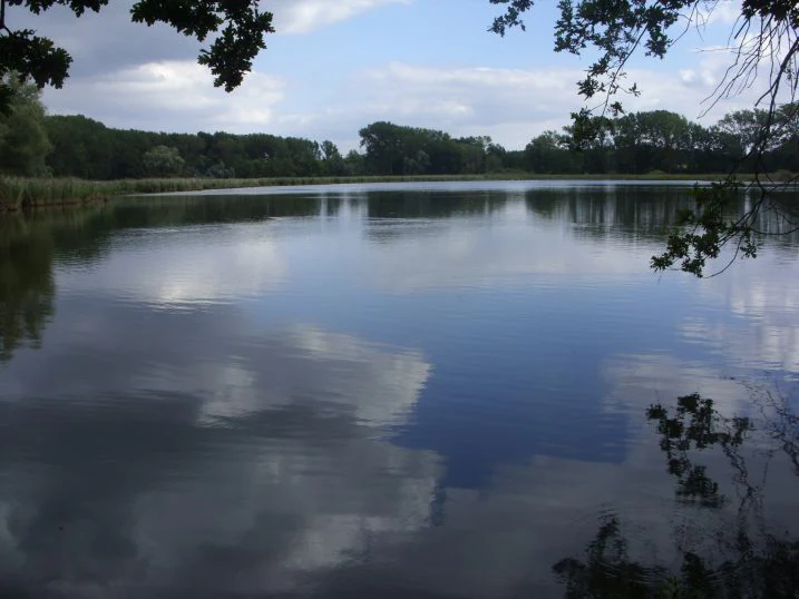
A wide view of a calm, reflective pond surrounded by a dense, dark green forest under a cloudy blue sky, with overhanging tree branches visible in the foreground.
A calm view across the Weddeler Teich, a protected water area.

Weddeler Teich history and protected-area timeline

The pond itself has a long pre-protection history. It was created by impounding water in the Weddeler Graben lowland and was operated as a carp pond for centuries, a traditional use that shaped the water body's depth, nutrient balance, and surrounding land use. Over time, the shallow basin began to silt up, and the pond gradually shifted from an actively managed aquaculture site toward a more naturalistic wetland.

The formal nature reserve was designated on 16 February 1981 under the code NSG BR 041, placing both the pond and its surrounding shore and wetland under statutory protection. Ever since, the Landkreis Wolfenbüttel's lower nature conservation authority has been the responsible body for the site. The reserve's establishment also linked it functionally with the neighboring Riddagshausen nature reserve, reinforcing a continuous corridor of protected habitat east of Braunschweig.

Weddeler Teich landscape and geographic character

The landscape of Weddeler Teich is defined by low and gentle terrain typical of the northern German lowlands. The pond sits in the shallow valley of the Weddeler Graben, slightly below the elevation of the surrounding land, and reads from a distance as a flat, marshy depression framed by low vegetation.

The shoreline is the most distinctive visual feature. Instead of steep banks or clean edges, the open water is gradually overtaken by dense reed beds of common reed and bulrush, creating a thick green belt that softens the transition between water and land. Beyond the reeds lie wetter meadow and marsh habitats, forming a clear buffer of moisture-loving vegetation around the basin.

Outside the reserve, the wider setting is overwhelmingly agricultural, with fields and pasture extending in most directions. This contrast between the wet, green core of the reserve and the cultivated land around it makes the wetland stand out clearly in the local landscape.
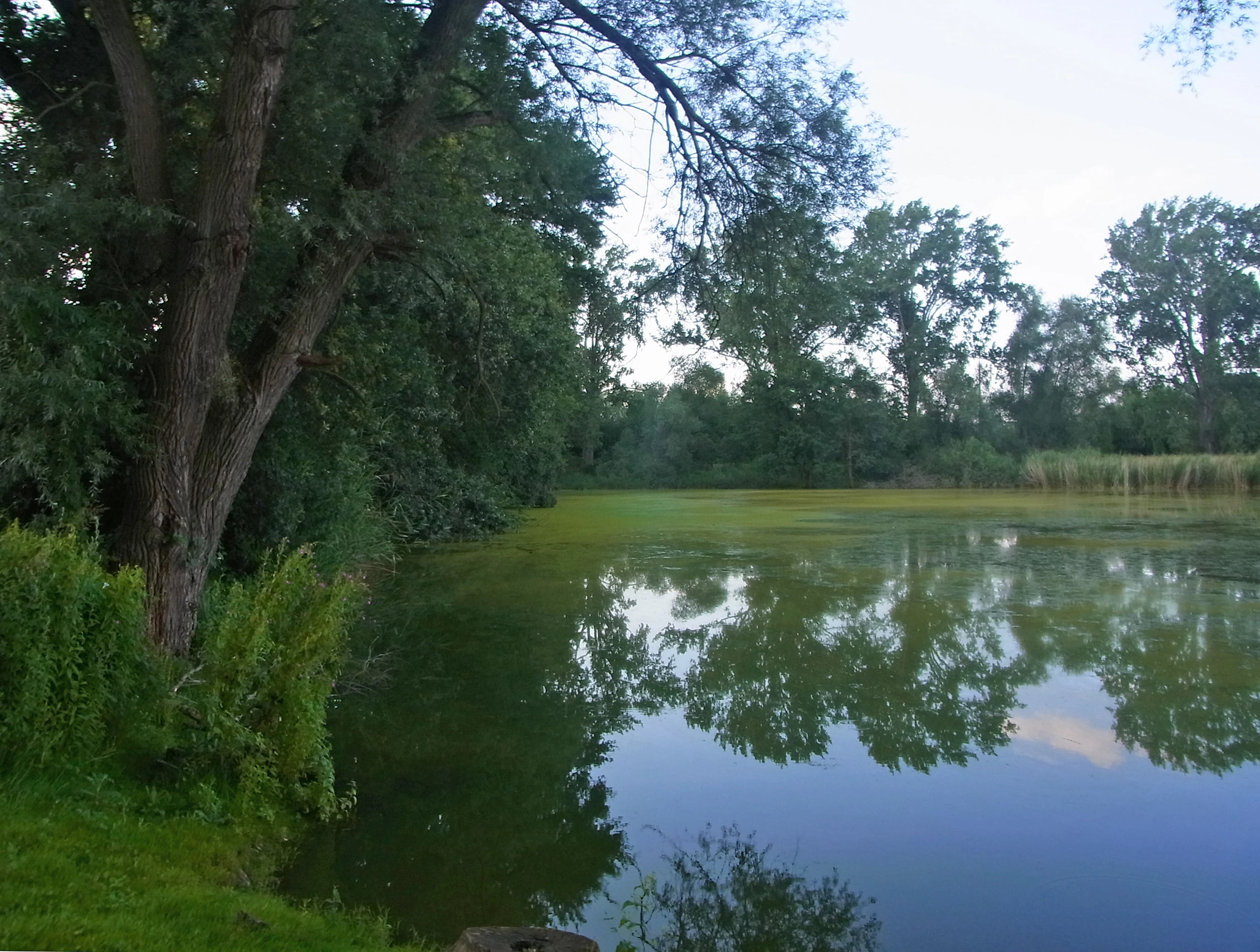
A calm, still pond with dark green water reflecting surrounding trees on a bright day.
A view of the Weddeler Teich pond, characterized by calm water and surrounding lush vegetation.

Weddeler Teich ecosystems, habitats, and plant life

Weddeler Teich's ecological character is shaped by the combination of a shallow, nutrient-rich pond and its surrounding wetland complex. The water body is eutrophic and partly silted up, conditions that have encouraged the encroachment of emergent vegetation rather than maintaining an open-water habitat.

Reed communities dominate the margin. Dense stands of common reed and bulrush form continuous belts along much of the shoreline, with a transition outward into wetter, more varied wetland plant communities. This zonation from open water through reed bed to wet meadow gives the small reserve a layered habitat structure that supports a wide range of species relative to its size.

The wetland serves as habitat for many animal groups, including several that are considered regionally threatened. Most importantly, the reed beds and surrounding marsh act as breeding and resting areas for a rich bird fauna, linking the site to broader networks of wetland-dependent birdlife in the region.
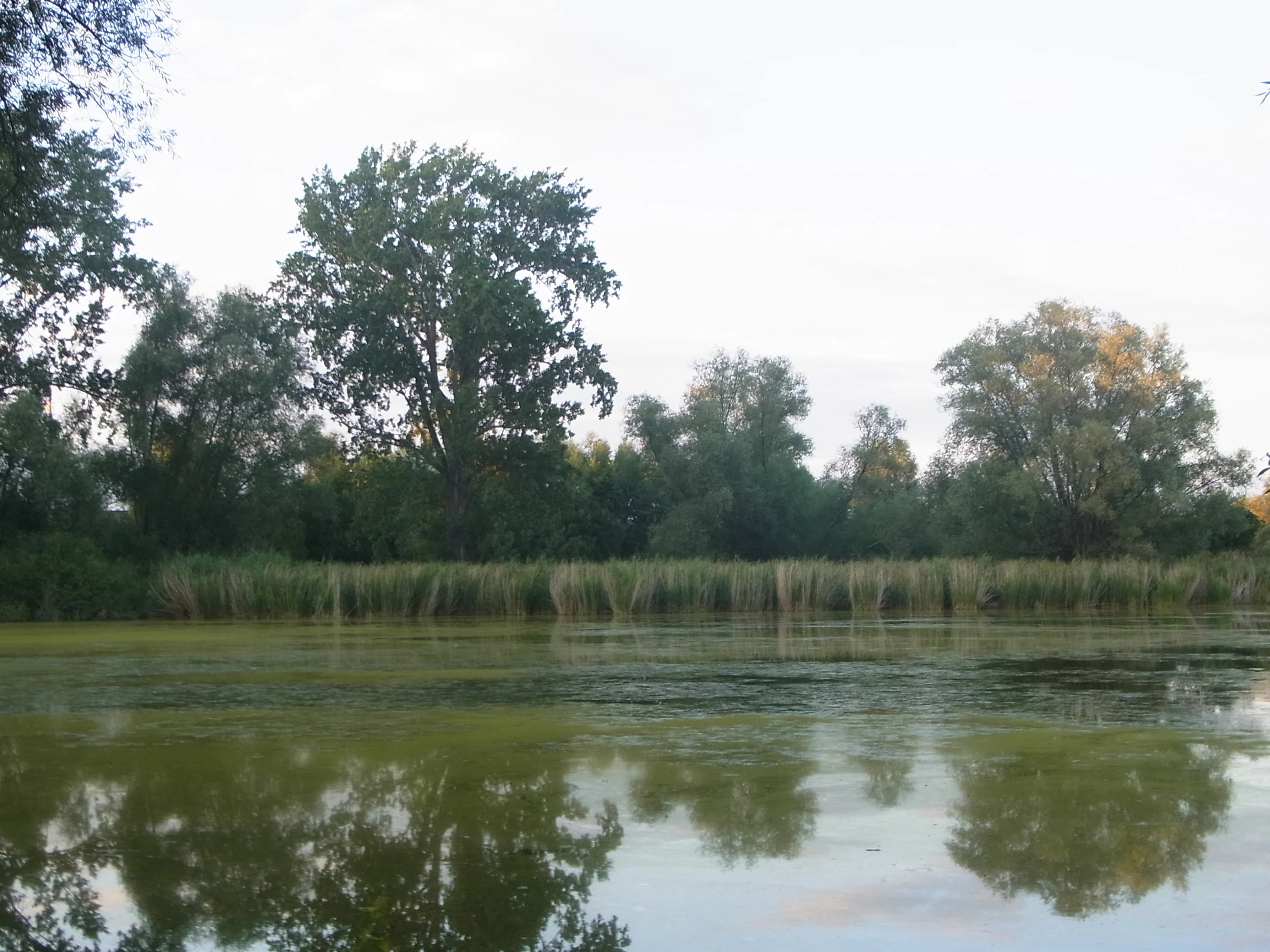
A calm, algae-covered pond reflecting the surrounding trees and sky, with a thick band of tall grass along the shoreline.
A view of the pond at Weddeler Teich, surrounded by lush vegetation and trees.

Weddeler Teich wildlife and species highlights

Birds are the most prominent feature of Weddeler Teich's wildlife. The extensive reed beds and adjacent wet meadows provide both nesting habitat for breeding species and resting habitat for migrating and wintering birds, making the reserve a locally significant bird site despite its small size.

The broader wetland supports a variety of other animal life associated with marshy, shallow-water environments. Some of the species present are considered threatened, which gives the site conservation weight beyond what its compact area might suggest. The dense reeds in particular offer cover and food resources for wetland-dependent fauna, while the more open wetter margins extend the range of habitat types available to wildlife.

Weddeler Teich conservation status and protection priorities

Weddeler Teich's conservation significance lies in its role as a small but high-quality wetland refuge within an intensively farmed agricultural landscape. By protecting a pond, its fringing reed beds, and the adjoining wetland as a single integrated site of roughly 20 hectares, the reserve concentrates ecological value into a compact area of the Landkreis Wolfenbüttel.

The site's importance is amplified by its connection to the nearby Riddagshausen nature reserve. Together, the two reserves form a continuous complex of protected habitat, increasing their combined value for species that require larger or more connected wetland areas than either site could provide alone. The designation of the site under the code NSG BR 041 since 16 February 1981 reflects formal recognition of its habitat, birdlife, and wetland functions, with the Landkreis Wolfenbüttel serving as the responsible lower nature conservation authority.

Weddeler Teich cultural meaning and human context

Weddeler Teich reflects a long tradition of human use of the local landscape. Before becoming a nature reserve, the pond functioned for centuries as a managed carp pond, a use that shaped both the water body and the surrounding land. The nearby village of Weddel and the broader Braunschweig region give the site a rural setting rooted in the agricultural rhythms of the Lower Saxon countryside.

The reserve now sits as an island of protected habitat amid farmland, illustrating how traditional rural infrastructure such as fish ponds can evolve into ecologically valuable nature sites once their original economic use fades and natural processes are allowed to reassert themselves.

Top sights and standout views in Weddeler Teich

Weddeler Teich's main highlights are its dense reed belts, its value as breeding and resting habitat for many bird species, and its connection with the adjoining Riddagshausen nature reserve. Despite covering only about 20 hectares, the reserve combines a shallow eutrophic pond, extensive reed beds, and surrounding wetland into a compact, layered habitat complex.

Its protected status since 1981 and its position within the Landkreis Wolfenbüttel's network of nature reserves give it additional reach, making it a small but well-established component of Lower Saxony's protected wetland heritage.

Best time to visit Weddeler Teich

Late spring and early summer are generally the most rewarding periods to experience Weddeler Teich, when the reed beds are in full growth and breeding bird activity is at its peak. Migratory and wintering birds use the site at other times of year, so quieter seasons can also offer interesting observations for those prepared to spend time along the margins.

Visitors should expect a small, low-key site rather than a dramatic landscape. The wetland's character changes subtly with the seasons, with the reed vegetation dominating the visual impression in summer and the open water becoming more visible once the reeds die back in autumn and winter.

Monthly climate preview

Long-term representative monthly averages and temperature ranges for Weddeler Teich

Weddeler Teich Climate Normals, Annual Temperature and Precipitation Rhythm

Historical NASA POWER coordinates record long-term temperature swings from sub-zero winter minimums to warm summer maximums alongside steady daily precipitation amounts. Examining the complete monthly climate breakdown provides deeper insight into annual meteorological patterns across the park terrain.
Annual mean9 °C
0 °C19 °C
Jan
Feb
Mar
Apr
May13°
Jun17°
Jul19°
Aug18°
Sep14°
Oct
Nov
Dec
Warmest month
July

18.6 °C

Coolest month
January

0.2 °C

Wettest month
July

2.6 mm/day

Driest month
April

1.4 mm/day

Park location guide

Geography guide, regional context, and park location map for Weddeler Teich

Weddeler Teich park geography, regions, and map view in Germany

Understand where Weddeler Teich sits in Germany through a broader geographic reading of the surrounding landscape, nearby location context, and its mapped position within the national park landscape.

How Weddeler Teich fits into Germany

Germany is a federal republic in Western and Central Europe with a population of over 83 million across sixteen constituent states. It is Europe's largest economy by nominal GDP and a major global exporter and importer. The capital is Berlin, and the country borders Denmark, Poland, Czech Republic, Austria, Switzerland, France, Luxembourg, Belgium, and the Netherlands.

Wider geography shaping Weddeler Teich in Germany

Germany is located in Western and Central Europe, spanning 357,022 km². It borders Denmark to the north, Poland and the Czech Republic to the east, Austria and Switzerland to the south, and France, Luxembourg, Belgium, and the Netherlands to the west. The country has coastlines on the Baltic Sea and North Sea to the north, with the Alps located in the southern region.

Map view of Weddeler Teich

Use this park location map to pinpoint Weddeler Teich in Germany, understand its exact geographic position, and read its mapped placement within the surrounding landscape more clearly.

Pigeon | © OpenStreetMap contributors

Location context for Weddeler Teich

Lower Saxony

Explore detailed visual records of reed beds, shallow waters, and marsh habitats surrounding the nature reserve.

Weddeler Teich Photos and Landscape Scenery: Visualizing the Protected Wetland

Visual documentation captures the shallow eutrophic pond, dense reed belts, and surrounding wet meadows that define the local terrain. Examining field photography helps researchers interpret habitat structure and ecological transitions within the protected landscape complex.

A wide view of a calm, reflective pond surrounded by a dense, dark green forest under a cloudy blue sky, with overhanging tree branches visible in the foreground.

A calm pond with tree reflections and silhouettes against a soft evening sky.

A calm, still pond with dark green water reflecting surrounding trees on a bright day.

A calm, algae-covered pond reflecting the surrounding trees and sky, with a thick band of tall grass along the shoreline.

Park atlas

Discover related wetland reserves and neighboring nature domains across Lower Saxony.

Parks Near Weddeler Teich: Explore Protected Areas and Surrounding Regional Landscapes

Browse protected areas and wetland habitats located near Weddeler Teich to compare regional geography and lowland reserves. Expanding the search reveals connected ecological networks across the agricultural surroundings of Lower Saxony.
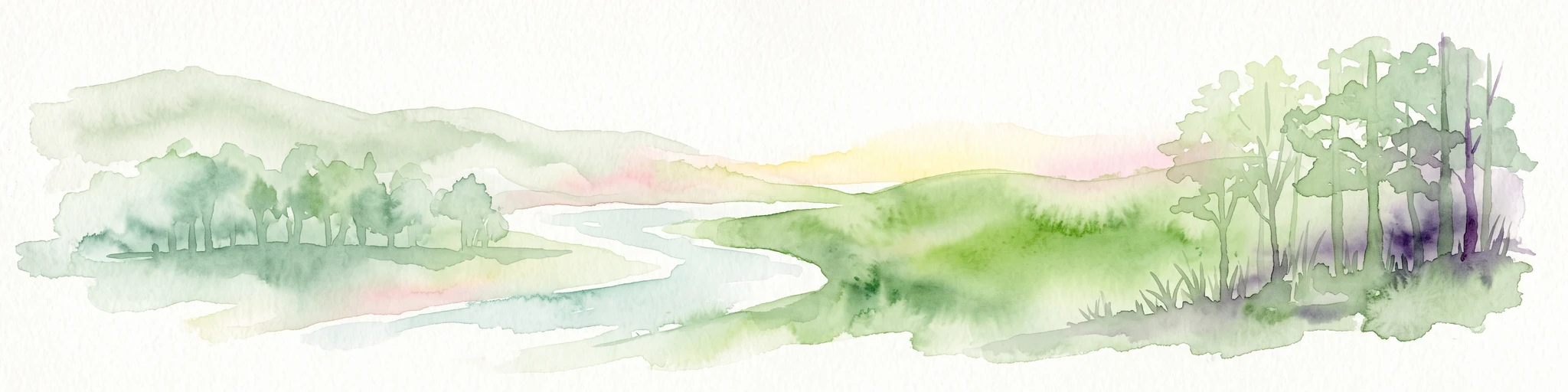
Watercolor illustration of a peaceful landscape featuring distant rolling hills, clusters of trees on the right, and a river or stream winding through a grassy plain against a pale background.
Protected landscapeLower Saxony
About 15 km away#1 closest

East

Dorm Protected Landscape: Geological Ridge and Forested Geography in Lower Saxony

Mapping the natural terrain and forest ecosystems of the East Brunswick hill country

Defined by its narrow anticline structure and diverse woodland mosaics, the Dorm stands as a vital protected area in Lower Saxony. This overview examines the ridge's geological composition, including its Triassic sandstone formations, saline habitats, and significant doline pools that characterize this prominent East Brunswick landmark.

Area
6.89 km²
Established
2020
Relief
Upland
Climate
Temperate
Nature reserveLower Saxony
About 23 km away#2 closest

Northwest

Viehmoor Nature Reserve: A Detailed Atlas of Wetland and Dune Landscapes in Lower Saxony

Protected lowlands, inland dunes, and riparian habitats

Viehmoor is a distinct 302-hectare protected area in Lower Saxony defined by its glacial history and diverse habitat transitions. The site features an inland dune ridge encircling a groundwater-fed lowland mire, alongside varied aquatic environments including reed-fringed fishponds and peat-cutting pools that provide vital breeding grounds for regional bird populations.

Area
3.02 km²
Established
1979
IUCN
IV
Nature reserveNiedersachsen
About 26 km away#3 closest

Northeast

Wendschotter und Vorsfelder Drömling mit Kötherwiesen: Protected Peatlands and Floodplains

Niedersachsen lowland geography and wetland habitat mapping

Spanning over 700 hectares in Wolfsburg, this nature reserve protects a complex network of marshes, reedbeds, and alluvial meadows. This atlas-focused overview examines the reserve's historic ditch systems, river corridors, and its role as a core component of the regional Drömling ecological network.

Area
7.22 km²
Established
2020
Relief
Lowland
Climate
Temperate
Nature reserveSalzgitter
About 28 km away#4 closest

Southwest

Tagebau Haverlahwiese Nature Reserve: Geography and Protected Area Mapping in Salzgitter

Mapping restored post-industrial landscapes and habitat mosaics.

This protected area in Salzgitter showcases the natural recovery of former ironstone mining lands. Users can examine the spatial arrangement of the 15-hectare mining lake, extensive reedbeds, and dry calcareous grassland slopes. The site remains a vital example of landscape conservation, illustrating how engineered topography provides new niches for amphibians and salt-tolerant plant communities across the Lichtenberge ridge.

Area
2.06 km²
Established
2016
Relief
Upland
Climate
Temperate
Nature reserveLandkreis Helmstedt
About 29 km away#5 closest

Northeast

Südlicher Drömling: Protected Floodplain Landscapes in Landkreis Helmstedt

Wetland nature reserve and alluvial forest geography

Südlicher Drömling represents a critical protected wetland area defined by the Aller river floodplain. The landscape provides a study in successional dynamics, featuring old-growth alluvial forests, species-rich wet meadows, and temporary open-water pools during seasonal flooding periods. It stands as an important regional anchor for migratory bird species and floodplain restoration within the broader Drömling basin.

Area
6.02 km²
Established
2018
Nature reserveLower Saxony
About 29 km away#6 closest

West

Wendesser Moor Nature Reserve: Mapped Wetland Geography and Protected Landscape Context in Lower Saxony

Exploring the peatland mosaic and marsh bird habitats of the Peine district

Wendesser Moor is a significant 63-hectare nature reserve in Lower Saxony, defined by its rare concentration of fen habitats, alder carr, and open peat pools. As a core component of a wider landscape protection zone, it provides essential refuge for threatened bird species. The reserve functions as a critical node in the local watershed, illustrating how small-scale protected peatlands maintain biodiversity in agricultural lowlands.

Area
0.632 km²
Established
1973
IUCN
IV
Relief
Lowland
Nature reserveLower Saxony
About 31 km away#7 closest

North

Vogelmoor Nature Reserve: Geographic Map and Protected Wetland Landscape in Lower Saxony

Birch bog forests, peat ponds, and rare mire habitats

Vogelmoor offers a deep look into the glacial topography of northern Germany. As a core protected area within the Gifhorn district, this site features a diverse assembly of sphagnum-rich forest, floating mats, and open heath. The reserve stands as a critical example of landscape restoration within a heavily agricultural region, providing essential refuge for wetland bird species and specialized bog vegetation.

Area
1.335 km²
Established
1974
IUCN
IV
Nature reserveWolfenbuettel
About 34 km away#8 closest

Southwest

Steinbruch Baddeckenstedt Nature Reserve: Protected Limestone Landscape in the Wolfenbuettel District

A restored former quarry environment with rich fossil deposits

Steinbruch Baddeckenstedt protects a six-hectare area of limestone cliffs and calcareous rubble slopes within the Wolfenbuettel district. This former quarry offers a specialized habitat for rare plants and wildlife, providing a vital example of post-industrial land conservation and geological exposure in central Germany.

Area
0.063 km²
Established
2009
IUCN
IV
Relief
Upland

Common questions about visiting, size, designation, and location context for Weddeler Teich

Weddeler Teich FAQs for park facts, access, geography, and protected area context

Find quick answers about Weddeler Teich, including protected-area facts, park geography, trail and visitor context, and how the park fits into its surrounding country and regional landscape.
MoriAtlas Explorer

Continue Your Protected Areas Search Across the Global Atlas

Deepen your exploration by continuing the structured search for national parks and protected areas worldwide. Utilize the comprehensive filtering capabilities to compare different conservation landscapes and refine your understanding of global park geography. Discover more about the distribution and characteristics of protected natural areas.

Global natural geography