
Mori Atlas logo
Nature reserveTal der Kleinen Örtze

Mapping the ecological restoration and woodland corridors of this Lower Saxony nature reserve

Tal der Kleinen Örtze Nature Reserve and Protected Stream Valley Landscape in Heidekreis

(Naturschutzgebiet Tal der Kleinen Örtze (NSG LÜ 207))

The Tal der Kleinen Örtze nature reserve protects a dynamic stream valley system in the Heidekreis region of Germany. This protected area highlights successful stream restoration, where former conifer plantations have been reclaimed by native deciduous floodplain forests. Users can examine the geography of this mosaic landscape, which bridges wet sedge marshes and bog remnants with the surrounding sandy terrain of the southern Lüneburg Heath.

nature reservestream valleybrook ecosystemfloodplain forestalder woodlandbeech forest
A stylized digital illustration of a lush river valley framed by tall, mossy trees in the foreground, with a winding river and a waterfall in the background under a soft, light-filled sky.

Tal der Kleinen Örtze

Nature reserve

Park overview

Structured park overview, official facts, and landscape profile for Tal der Kleinen Örtze

Tal der Kleinen Örtze park facts, protected area profile, and essential visitor context

Review the core facts for Tal der Kleinen Örtze, including designation, size, terrain, visitor scale, habitats, and operating context in one park-focused overview.

About Tal der Kleinen Örtze

Tal der Kleinen Örtze lies on the southern periphery of the Lüneburg Heath, southeast of the town of Munster in the Heidekreis district of Lower Saxony. Though modest in size at roughly 450 hectares, it occupies a strategically important ecological position within a larger landscape mosaic that includes coniferous forest, heathland, military training areas, and the broader Örtze river catchment.

The reserve consists of two main sections. One follows a stretch of the Örtze south of Munster; the other, and more characteristic, traces the narrow valley of the Kleine Örtze from about 800 meters below its source southward to its confluence with the Örtze at Kreutzen, near the former village of Trauen. Throughout much of its length the valley is relatively steep-sided, sheltering shade-tolerant vegetation and creating the moist, sheltered microclimate that defines the area's ecological character.

What sets Tal der Kleinen Örtze apart from many comparable Lower Saxon reserves is the depth of its restoration history. Earlier in the 20th century, the upper valley had been heavily modified: a former high moor was drained, the brook was widened into a straightening ditch, and the cleared ground was replanted with spruce. After designation in 1993, the spruce was removed, the brook allowed to redevelop its own meandering course, and the surrounding slopes regenerated as alder, birch, oak, and beech woodland. This combination of hydrological recovery and forest rewilding on former plantation land gives the reserve a distinctive profile among stream-valley protected areas in the region.

Quick facts and research context for Tal der Kleinen Örtze

Tal der Kleinen Örtze is a nature reserve (Naturschutzgebiet) administered by the Heidekreis district in Lower Saxony, northern Germany, located southeast of Munster within the broader Lüneburg Heath region. Its official designation is NSG LÜ 207, and it is managed under IUCN Category IV as a habitat and species management area.

The reserve covers about 450 hectares across two sections, almost entirely overlapping with the EU Habitats Directive site (FFH-Gebiet) "Örtze mit Nebenbächen" and adjoining the landscape protection area "Munster-Oerrel". It protects sections of the Örtze and its tributary Kleine Örtze along with their floodplains, marshy grasslands, bog fragments, and adjacent deciduous forests. First established in 1993 and significantly expanded and re-decreed in January 2019, the area stands out for its combination of stream restoration, woodland rewilding on former conifer plantations, and conservation of small, scattered bog and heath habitats.

Protection and recognition

Terrestrial conservation framework and official registry history

Tal der Kleinen Örtze Protection Status and Designation Records

Tal der Kleinen Örtze maintains a recorded terrestrial protection status established in 2019 within official protected area databases. Systematic registry records aggregate the documented designation timeline and management scope for this conservation area.

Protection details

Protection scope
Terrestrial
Designated year
2019
Transboundary protection
No
WDPA ID
165811
Park context

Deeper park guide and search-rich context for Tal der Kleinen Örtze

Tal der Kleinen Örtze history, landscape, wildlife, and travel context

Explore Tal der Kleinen Örtze through its history, landscape character, ecosystems, wildlife, conservation priorities, cultural context, and seasonal travel timing in a structured park guide built for atlas discovery and search intent.

Why Tal der Kleinen Örtze stands out

The reserve is best known for the restoration of the upper Kleine Örtze valley, where former high moor and drainage infrastructure were removed and replaced with near-natural deciduous forest and a freely meandering brook. It is also recognized for the contrast between narrow, shaded floodplain forest along the streams and open heath and marsh fragments on surrounding sandy soils at the margins of the Lüneburg Heath. Its stream fauna, including brook trout, bullhead, and European brook lamprey, along with otters, kingfishers, and dippers, gives the area additional recognition as one of the more intact small lowland brook ecosystems in the Heidekreis. The combination of active rewetting, woodland recovery, and protection of small bog remnants makes it a frequently cited example of stream-valley conservation in Lower Saxony.
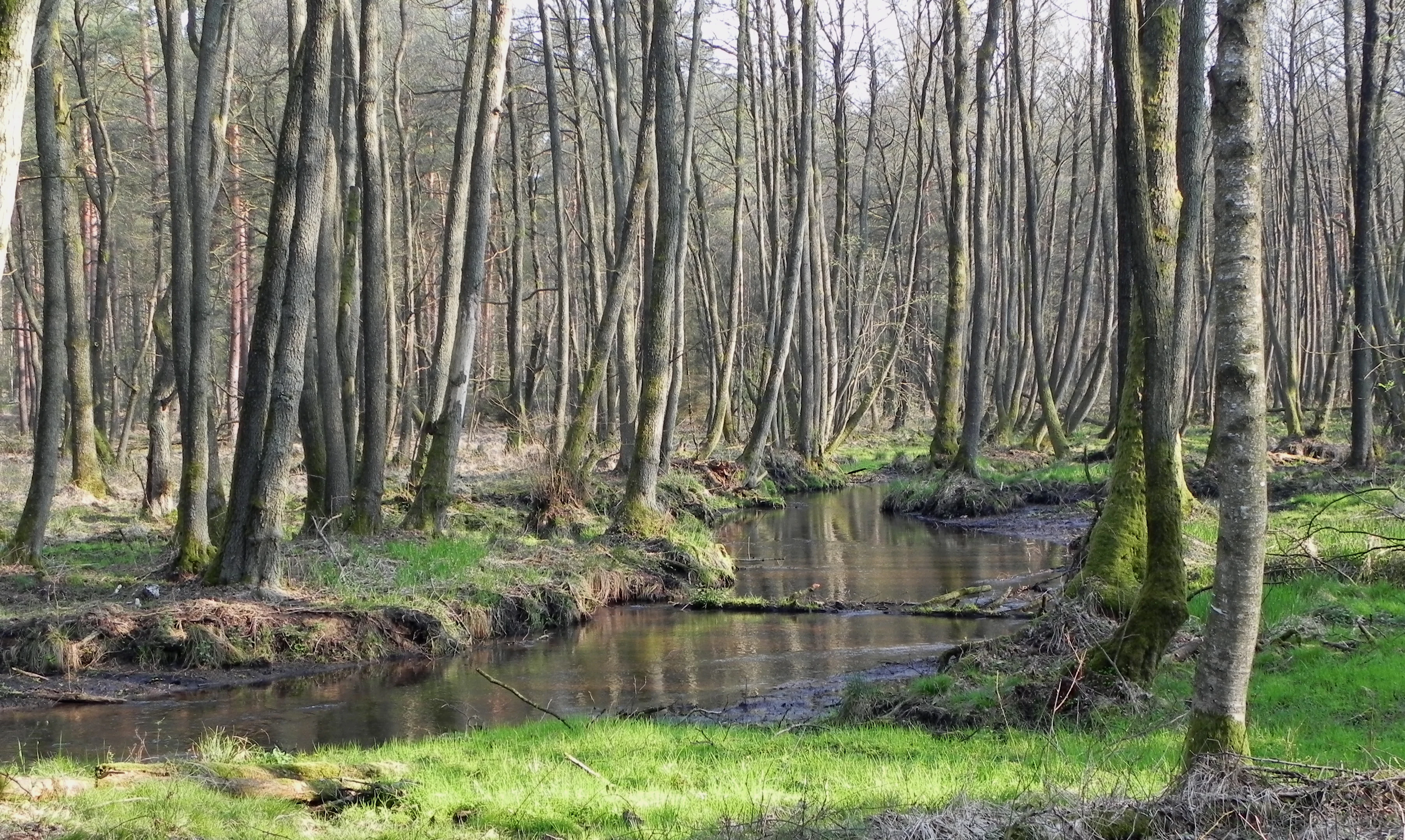
A small, calm stream winds through a dense alder forest in a nature reserve, with green grassy banks and tall tree trunks.
The Kleine Örtze stream flowing through an alder carr forest.

Tal der Kleinen Örtze history and protected-area timeline

Tal der Kleinen Örtze was first placed under formal nature protection on 2 September 1993, initially covering around 330 hectares along the valley of the Kleine Örtze, within what was then the area of the Samtgemeinde Munster in Lower Saxony. At that time, it was decreed under the designation NSG LÜ 207, with the Heidekreis district acting as the responsible lower nature conservation authority.

A revised protection ordinance came into force on 26 January 2019, substantially reshaping the reserve. The area was extended to about 450 hectares by adding a new section along the Örtze south of Munster. In doing so, parts of the adjoining landscape protection area "Munster-Oerrel" were absorbed into the reserve, tightening protection along the stream system.

The new ordinance also formalized a conservation philosophy anchored in restoration. Earlier drainage of the upper valley and the conversion of former moorland into a sprout plantation were reversed during the years following initial designation, with the brook returned to a more natural dynamic and the conifer stands replaced by near-natural deciduous woodland. Today the reserve is administered under the oversight of the Lower Saxony State Agency for Water Management, Coastal Defence, and Nature Conservation (NLWKN), with on-the-ground responsibility remaining with the Heidekreis district.

Tal der Kleinen Örtze landscape and geographic character

The landscape of Tal der Kleinen Örtze is defined by narrow, often sharply incised brook valleys set within the broader undulating sandy terrain of the southern Lüneburg Heath. The Kleine Örtze runs through a comparatively tight valley, with slopes on either side falling toward a winding, low-energy stream course. Where the valley broadens slightly, moist floodplain terraces interrupt the steeper woodland edges, and small natural depressions hold bog fragments and seasonal wetland pockets.

In contrast, the section of the Örtze included in the reserve flows through a wider lowland corridor south of Munster, where flatter meadows and grazed grassland dominate. Sandy, nutrient-poor soils along the valley margins support dry heath vegetation, including heather-dominated communities, while the valley floors and seepage zones carry sedge marshes, reedbeds, and tall-herb meadows. The remnants of the former Hahnenmoorsee near Oerrel, where a mill weir was removed and the impoundment has since been allowed to silt up, illustrate how the landscape has gradually shifted back toward a more natural hydrological state.

Although the reserve lies close to major transportation corridors and the Munster military training area, the core valley sections retain an atmosphere of quiet enclosure. Forest edges close in around the streams, and the visible landforms are modest in scale but consistent and characteristic of the late-glacial stream valleys that shape much of the southern Lüneburg Heath.
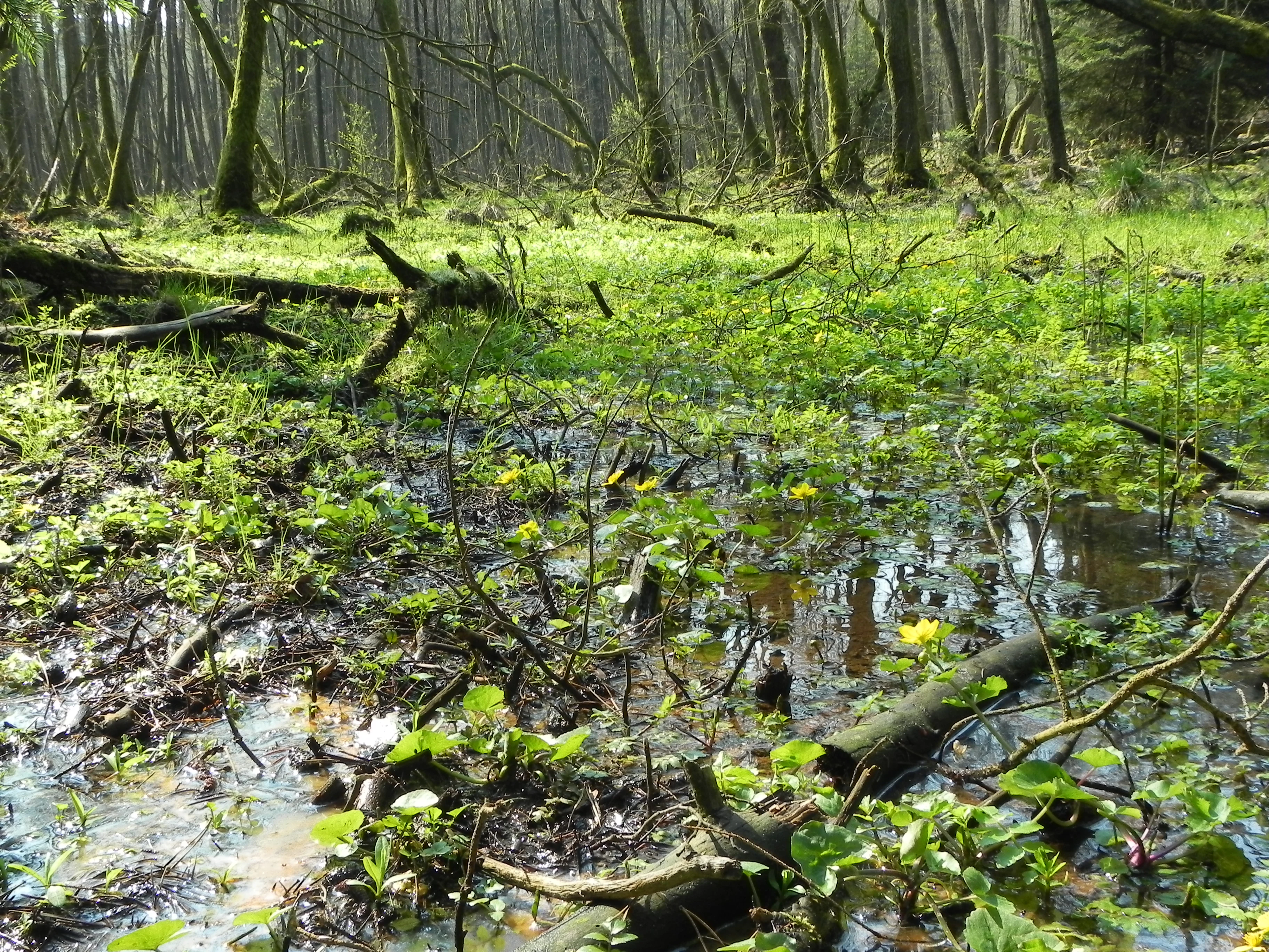
A swampy woodland floor with standing water and yellow marsh marigold flowers surrounded by fallen logs and tree trunks in a green forest.
A flooded floodplain forest in the Tal der Kleinen Örtze nature reserve, characterized by marshy ground and marsh marigolds.

Tal der Kleinen Örtze ecosystems, habitats, and plant life

Ecologically, Tal der Kleinen Örtze represents a stacked transition between dry sandy heathland and permanently moist, nutrient-enriched floodplain habitats. The valley floors and lower slopes are dominated by alder and birch floodplain forest, in which black alder and downy birch form a dense, seasonally wet canopy. Above the floodplain zone, the slopes carry mixed deciduous woodland with pedunculate oak and European beech, often grading into more open hazel and birch transitions on the upper edges of the valley.

Wetland habitats form a continuous thread through the valley. Reedbeds, sedge marshes, and tall-herb communities colonize the flatter reaches and seepage areas, while scattered small bogs, kettle-like slacks, and moist heath fragments add structural diversity. Characteristic plants of these small bog and wet-heath patches include cross-leaved heath, common heather, beak-sedge, bog asphodel, and marsh gentian. On the drier, sandier slopes beyond the stream corridor, heather sand-heath communities with common heather occur, reflecting the area's transitional position toward the surrounding Lüneburg Heath landscape.

The streams themselves, particularly the upper reaches of the Kleine Örtze, are central to the reserve's ecological identity. Since the removal of conifer plantations and the abandonment of the drainage ditch, the brook has reclaimed a more natural braided, sedge- and herb-lined course, with abundant in-stream wood, varied sediment structures, and restored hydrological connectivity. This makes the area a notable example of lowland brook recovery within the broader heathland river systems of northern Germany.
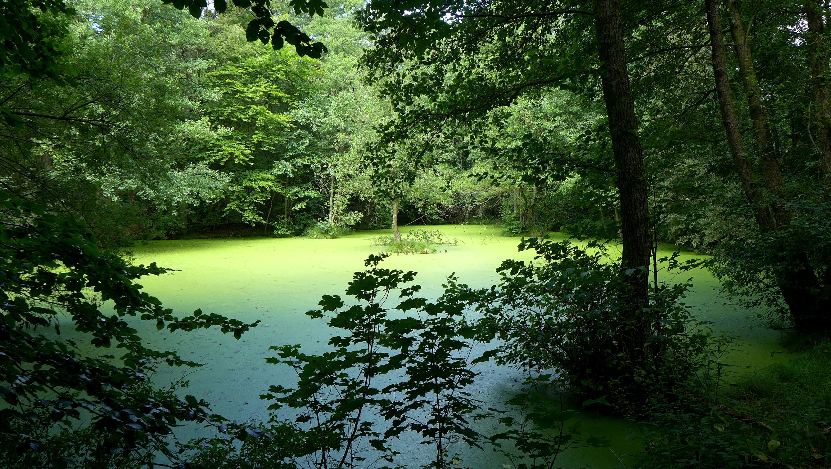
A small, calm pond surrounded by dense forest, with the water surface almost entirely covered in a vibrant green layer of duckweed.
A tranquil pond covered in duckweed within the forest of the Tal der Kleinen Örtze nature reserve.

Tal der Kleinen Örtze wildlife and species highlights

The streams and their marginal zones form the backbone of the reserve's wildlife interest. The Örtze and the Kleine Örtze host a characteristic community of small lowland brook fishes, including bullhead, European brook lamprey, minnow, grayling, and brown trout. Stone loach is among the additional species recorded in the gravelly and sometimes silty reaches, and the presence of brook lamprey in particular reflects the improved continuity and quality of the streambed.

Along the stream margins, otters use the watercourses and surrounding wetland patches as a regular travel and foraging corridor, while the steep, partially shaded banks provide nesting habitat for kingfisher and white-throated dipper. The reserve's varied dragonfly fauna, which includes banded demoiselle, blue-winged demoiselle, Asian emerald, green snaketail, and two-striped springdragon, indicates a healthy mix of slow-flowing and well-oxygenated sections, both bordered by tall vegetation and interrupted by sun-lit openings.

Bats are also an important component of the fauna, exploiting the mosaic of woodland, wetland edge, and open zones for foraging, while the mix of wet meadows, marsh, and small reedbeds provides habitat for amphibians, waterbirds, and a wide range of invertebrates. Although large mammal populations are limited by the reserve's modest size, deer, fox, and a variety of smaller mammals regularly use the valley as a continuous wildlife corridor through the otherwise heavily used heathland surroundings.
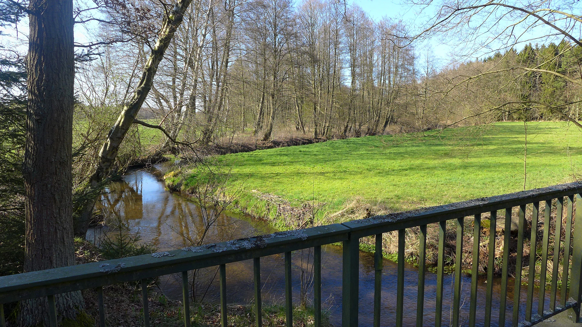
A view of a small, calm river flowing through a green meadow, framed by trees and a metal railing in the foreground.
The Kleine Örtze river winding through the nature reserve landscape near Munster.

Tal der Kleinen Örtze conservation status and protection priorities

From a conservation perspective, Tal der Kleinen Örtze is significant primarily as a stream-valley restoration site within the larger Örtze catchment. Almost the entire reserve is part of the EU Habitats Directive site "Örtze mit Nebenbächen", giving it formal recognition as a contribution to the European Natura 2000 network. Its status as an IUCN Category IV habitat and species management area reflects a focus on targeted intervention rather than strict wilderness protection, which is appropriate given the heavily modified history of much of the valley.

The reserve's conservation strategy emphasizes the recovery of near-natural stream dynamics, including the removal of bank fixings, the reintroduction of in-stream wood, and the renouncement of active channel maintenance in favor of allowing the river to choose its own course. Forest restoration on former spruce plantations has converted significant areas back to alder and oak-beech woodland, with the result that large parts of the upper Kleine Örtze now function as a self-regulating gallery forest.

Equally important is the protection of the smaller, scattered habitats: the fragments of high bog that remain, the kettle-like slacks, the moist heath pockets, and the dry sand-heath transitions. While individually modest in area, these features are representative of the once more extensive heathland-and-bog mosaic of the southern Lüneburg Heath and are maintained through appropriate grazing and, where possible, rewetting.

Tal der Kleinen Örtze cultural meaning and human context

The reserve overlaps with landscapes shaped by long-standing low-intensity land use. The valley's meadows near Trauen and along the Örtze have traditionally been mown rather than heavily fertilized, and the deciduous woodland on the slopes reflects centuries of forest grazing and selective use rather than industrial forestry. The former village of Trauen, now part of Munster, lends the valley its cultural anchor: a small settlement along a brook that has long determined the rhythm of local life.

The presence of an old mill impoundment near Trauen, now in ruins, and the earlier existence of the artificially created Hahnenmoorsee at Oerrel are reminders of how strongly past generations reshaped the valley's hydrology for water power, peat cutting, and land reclamation. Today, the deliberate undoing of some of these changes, including weir removal, drainage reversal, and conifer clearance, marks a thoughtful shift in how local communities and conservation authorities view the valley's value.

The broader Munster area, including the adjacent military training area, also gives the region a distinctive cultural layer, where tight-knit rural communities coexist with large-scale military and training landscapes. Within that context, Tal der Kleinen Örtze functions as a small but valued piece of recognized natural heritage that links the town's identity to the surrounding heathland river systems.

Top sights and standout views in Tal der Kleinen Örtze

Tal der Kleinen Örtze combines quiet, steep-sided brook-valley scenery with one of the more active stream restoration histories in the Heidekreis. The former spruce plantation on drained high moor in the upper valley has been transformed into near-natural deciduous woodland, and the brook now follows its own wandering course beneath alder and birch.

The reserve's transition zones, where wet floodplain forest meets dry sand heath, small raised bog remnants, and extensively used meadows, capture the ecological richness of the southern Lüneburg Heath at a very local scale. A rich community of brook fishes, otters, kingfishers, white-throated dippers, and numerous dragonflies and bats adds further definition, making this a particularly valued part of Lower Saxony's protected area network.

Best time to visit Tal der Kleinen Örtze

Spring is particularly rewarding in Tal der Kleinen Örtze, when the valley floor fills with marsh marigolds along the Kleine Örtze and woodland ground cover responds to rising temperatures. The mix of fresh green foliage on alder and birch and the still-open landscape on the drier slopes gives a strong sense of seasonal renewal.

Summer brings the densest vegetation and the warmest conditions along the streams, with dragonflies in evidence along the more open reaches and a full canopy over much of the valley. In late summer and early autumn the heather on the marginal heath patches comes into bloom, adding purple tones to the sandy edges of the reserve. Winter visits are quiet and atmospheric, when the bare deciduous trees allow clearer views of the valley structure, the streams, and the birdlife that uses them.


Monthly climate preview

Examine long-term representative temperature and precipitation averages across twelve months.

Tal der Kleinen Örtze Climate Normals and Annual Weather Patterns

Long-term representative records for Tal der Kleinen Örtze document a measured annual cycle of mean temperatures ranging from near freezing to warm summer highs alongside steady daily precipitation. Reviewing the complete monthly climate data provides detailed baseline context for evaluating regional meteorological patterns.
Annual mean9 °C
0 °C18 °C
Jan
Feb
Mar
Apr
May13°
Jun16°
Jul18°
Aug18°
Sep14°
Oct
Nov
Dec
Warmest month
July

18.3 °C

Coolest month
January

0.4 °C

Wettest month
July

2.6 mm/day

Driest month
April

1.4 mm/day

Park location guide

Geography guide, regional context, and park location map for Tal der Kleinen Örtze

Tal der Kleinen Örtze park geography, regions, and map view in Germany

Understand where Tal der Kleinen Örtze sits in Germany through a broader geographic reading of the surrounding landscape, nearby location context, and its mapped position within the national park landscape.

How Tal der Kleinen Örtze fits into Germany

Germany is a federal republic in Western and Central Europe with a population of over 83 million across sixteen constituent states. It is Europe's largest economy by nominal GDP and a major global exporter and importer. The capital is Berlin, and the country borders Denmark, Poland, Czech Republic, Austria, Switzerland, France, Luxembourg, Belgium, and the Netherlands.

Wider geography shaping Tal der Kleinen Örtze in Germany

Germany is located in Western and Central Europe, spanning 357,022 km². It borders Denmark to the north, Poland and the Czech Republic to the east, Austria and Switzerland to the south, and France, Luxembourg, Belgium, and the Netherlands to the west. The country has coastlines on the Baltic Sea and North Sea to the north, with the Alps located in the southern region.

Map view of Tal der Kleinen Örtze

Use this park location map to pinpoint Tal der Kleinen Örtze in Germany, understand its exact geographic position, and read its mapped placement within the surrounding landscape more clearly.

Pigeon | © OpenStreetMap contributors

Location context for Tal der Kleinen Örtze

Landkreis HeidekreisNiedersachsen

Visual exploration of protected stream valleys, alder woodlands, and lowland brook habitats

Tal der Kleinen Örtze Photos and Landscape Scenery

Visual documentation of Tal der Kleinen Örtze reveals the intricate terrain of narrow brook corridors, meandering streams, and wet floodplain forests across the Lüneburg Heath. Studying these protected-area photographs helps observers understand the restored hydrological character and diverse wetland habitats that define the reserve.

A small, calm stream winds through a dense alder forest in a nature reserve, with green grassy banks and tall tree trunks.

A small, winding river flowing through a lush green floodplain forest with deciduous trees.

A swampy woodland floor with standing water and yellow marsh marigold flowers surrounded by fallen logs and tree trunks in a green forest.

A small, calm pond surrounded by dense forest, with the water surface almost entirely covered in a vibrant green layer of duckweed.

A view of a small, calm river flowing through a green meadow, framed by trees and a metal railing in the foreground.

A calm, still lake surrounded by deciduous trees and marsh grasses under soft daylight.

Park atlas

Compare surrounding stream valleys, wetland reserves, and protected lowland landscapes

Parks Near Tal der Kleinen Örtze and Related Protected Areas in Regional Geography

Continue exploring other parks near Tal der Kleinen Örtze to compare adjacent stream valleys and lowland reserves across the surrounding region. Reviewing connected protected landscapes provides broader geographic context for the wetland habitats and stream ecosystems defining local terrain.
Nature reserveLower Saxony
About 13 km away#1 closest

West

Wittenmoor Nature Reserve: Geographic Atlas of a Protected Raised Bog in Lower Saxony

Peatland conservation and wetland terrain in the Heidekreis district

Wittenmoor offers a focused view into the peatland dynamics of Lower Saxony. The protected area features two distinct sections characterized by hand-cut peat extraction pools, floating moss mats, and bog-adapted flora. This site provides a clear look at how small-scale reserve management restores hydrological health to marshy meadows and transition-zone moor heath environments within an agricultural landscape.

Area
0.28 km²
Established
1999
IUCN
IV
Relief
Lowland
Nature reserveLower Saxony
About 14 km away#2 closest

South

Weesener Bach Nature Reserve: Protected Stream and Riparian Geography in the Celle District

Examining mapped boundaries and habitat preservation in Lower Saxony

Discover the geographic footprint of Weesener Bach, a dedicated nature reserve in the Celle district of Lower Saxony. This site focuses on the long term development of stream systems and associated riparian habitats, offering a clear look at specialized land management within the southern Lüneburg Heath region.

Area
2.58 km²
Established
1999
IUCN
IV
Scope
Terrestrial
Nature reserveNiedersachsen
About 16 km away#3 closest

West

Wietzendorfer Moor: Geographic Analysis of Protected Bog and Wetland Landscapes

Nature reserve terrain in Niedersachsen, Germany

Discover the physical layout of Wietzendorfer Moor, an intricate nature reserve defined by restored raised bog habitats and historical polders. This atlas entry provides geographic context on the wet meadow systems and sand trails that define this unique Lüneburg Heath landscape, highlighting the spatial distribution of its protected parcels.

Area
2.1 km²
Established
1998
IUCN
IV
Relief
Lowland
Nature reserveLandkreis Uelzen
About 16 km away#4 closest

Northeast

Wettenbosteler Moor Protected Area: Geographic Overview and Mapped Landscape Features

A resilient raised bog remnant in the Landkreis Uelzen heath forest

Spanning roughly thirteen hectares, Wettenbosteler Moor preserves a rare spring-fed bog habitat characterized by peat-forming vegetation and pine forest borders. This nature reserve offers deep insights into the drainage networks and lowland terrain of the Lüneburg Heath, mapping the transition between upland forest and valley mire.

Area
0.128 km²
Established
1977
IUCN
IV
Relief
Lowland
A horizontal watercolor painting depicting a rolling heathland landscape with purple heather, evergreen trees, and a central water feature under a soft sky.
Protected landscapeLower Saxony
About 29 km away#5 closest

Northwest

Naturpark Lüneburger Heide: Protected Landscape Map and Regional Geography

An expansive cultural landscape in northern Lower Saxony

Spanning over 1,000 square kilometers, Naturpark Lüneburger Heide preserves the largest contiguous inland heathlands in Central Europe. Use this atlas resource to understand the park's glacial terrain, including karst sinkholes and natural springs, as well as its status as a model region for sustainable conservation and traditional land management practices.

Area
1,097.85 km²
Established
1922
IUCN
V
Relief
Lowland
Nature reserveLandkreis Uelzen
About 30 km away#6 closest

East

Vogelfreistätte Jastorfer See Nature Reserve in Landkreis Uelzen, Germany

Wetland habitat and river valley protected area

Vogelfreistätte Jastorfer See is a protected wetland landscape located in the Ilmenau valley. This nature reserve, spanning 16.5 hectares, preserves a mosaic of open water and alder swamp forest that sustains diverse bird populations including kingfishers and marsh harriers. It serves as a regionally significant conservation site, embedded within the broader Ilmenautal protected corridor in northern Germany.

Area
0.165 km²
Established
1977
IUCN
IV
Relief
Lowland
Nature reserveUelzen District
About 32 km away#7 closest

Northeast

Vierenbach Nature Reserve: Landscape Geography and Protected Area Mapping in Uelzen District

A study of lowland stream valleys and swamp forest ecosystems.

Vierenbach serves as a crucial lowland stream sanctuary in the Uelzen District, featuring a concentrated variety of alder and ash swamp forests, birch bog woodlands, and wet fen grasslands. This entry offers a deep look into the reserve's unique transition zones between waterlogged valley floors and drier oak-hornbeam Geest slopes.

Area
2.3 km²
Established
2004
IUCN
IV
Nature reserveLower Saxony
About 39 km away#8 closest

North

Wittsaal Nature Reserve: Mapped Wetland Geography and Protected Landscape in Lower Saxony

A rare mosaic of moor ponds and swamp woodland

Wittsaal is a specialized nature reserve in the Lüneburg region of Lower Saxony, Germany. The area protects a peat-cut moor pond currently undergoing natural silting, surrounded by willow-dominated swamp woodland, reedbeds, and sedge marshes. This compact site provides a critical, quiet refuge for wetland ecology within a wider landscape of agricultural fields and transitional glacial terrain.

Area
0.13 km²
Established
1985
IUCN
IV
Relief
Lowland

Common questions about visiting, size, designation, and location context for Tal der Kleinen Örtze

Tal der Kleinen Örtze FAQs for park facts, access, geography, and protected area context

Find quick answers about Tal der Kleinen Örtze, including protected-area facts, park geography, trail and visitor context, and how the park fits into its surrounding country and regional landscape.
MoriAtlas Explorer

Continue Your Protected Areas Search Across the Global Atlas

Deepen your exploration by continuing the structured search for national parks and protected areas worldwide. Utilize the comprehensive filtering capabilities to compare different conservation landscapes and refine your understanding of global park geography. Discover more about the distribution and characteristics of protected natural areas.

Global natural geography