
Mori Atlas logo
Nature reserveWeesener Bach

Analyzing the protected boundaries and riparian habitat systems of the Celle district

Weesener Bach Nature Reserve: A Detailed Geographic Overview of Protected Riparian Landscapes in Lower Saxony

Weesener Bach represents a vital nature reserve situated within the Celle district of Lower Saxony. This protected area focuses on the conservation of stream and riparian ecosystems, serving as a key component of the regional habitat network across the southern Lüneburg Heath. Through mapping and boundary analysis, the site illustrates a clear commitment to habitat and species management within its designated 258 hectare range.

nature reservestreamriparian habitatLower SaxonyCelle districtIUCN Category IV
A colorful flat illustration showing a narrow blue stream flowing through a forest towards a small waterfall in the distance, viewed from behind a wooden footbridge under a bright sun.

Weesener Bach

Nature reserve

Park overview

Structured park overview, official facts, and landscape profile for Weesener Bach

Weesener Bach park facts, protected area profile, and essential visitor context

Review the core facts for Weesener Bach, including designation, size, terrain, visitor scale, habitats, and operating context in one park-focused overview.

About Weesener Bach

Weesener Bach is a compact, stream-focused nature reserve in the southern part of the Lüneburg Heath region of Lower Saxony. Although the reserve is modest in size by German standards at roughly 258 hectares, it sits within a district-level network of protected sites that collectively safeguard the region's characteristic mix of streams, moors, heath, and mixed forest.

The reserve was established on 2 June 1999 under the formal nature reserve designation (Naturschutzgebiet) used in German conservation law. It is registered under the code NSG LÜ 248, and internationally it carries WDPA ID 319294 and an IUCN Category IV classification, indicating that it is managed primarily for the conservation of specific habitats and species rather than as a strictly protected wilderness area.

Functionally, the reserve exists to maintain and develop the Weesener Bach, a small lowland watercourse, along with the habitats that surround it. By protecting the stream channel, its riparian vegetation, and the directly connected terrestrial habitats, the site provides a refuge for native flora and fauna in an otherwise heavily used cultural landscape. The Landkreis Celle acts as the responsible lower nature conservation authority for management and oversight.

Quick facts and research context for Weesener Bach

Weesener Bach is a designated nature reserve of about 258 hectares in the Celle district of Lower Saxony, Germany. It carries the official nature reserve code NSG LÜ 248 and is registered in the World Database on Protected Areas under WDPA ID 319294. The site was placed under formal protection on 2 June 1999 and is managed as an IUCN Category IV Habitat/Species Management Area by the Landkreis Celle as the responsible lower nature conservation authority.

Protection and recognition

Examine official terrestrial protection records and designation frameworks for Weesener Bach.

Weesener Bach Protection Status and Documented Conservation Scope

Terrestrial protection records for Weesener Bach outline the established conservation scope and administrative framework associated with the protected area. Structured datasets compile verified designation metrics to support accurate analysis of environmental management parameters.

Protection details

Protection scope
Terrestrial
WDPA ID
319294
Park context

Deeper park guide and search-rich context for Weesener Bach

Weesener Bach history, landscape, wildlife, and travel context

Explore Weesener Bach through its history, landscape character, ecosystems, wildlife, conservation priorities, cultural context, and seasonal travel timing in a structured park guide built for atlas discovery and search intent.

Why Weesener Bach stands out

The reserve protects the Weesener Bach stream and its associated habitats, securing a small, ecologically valuable lowland stream system in the Celle district of Lower Saxony under IUCN Category IV habitat and species management.
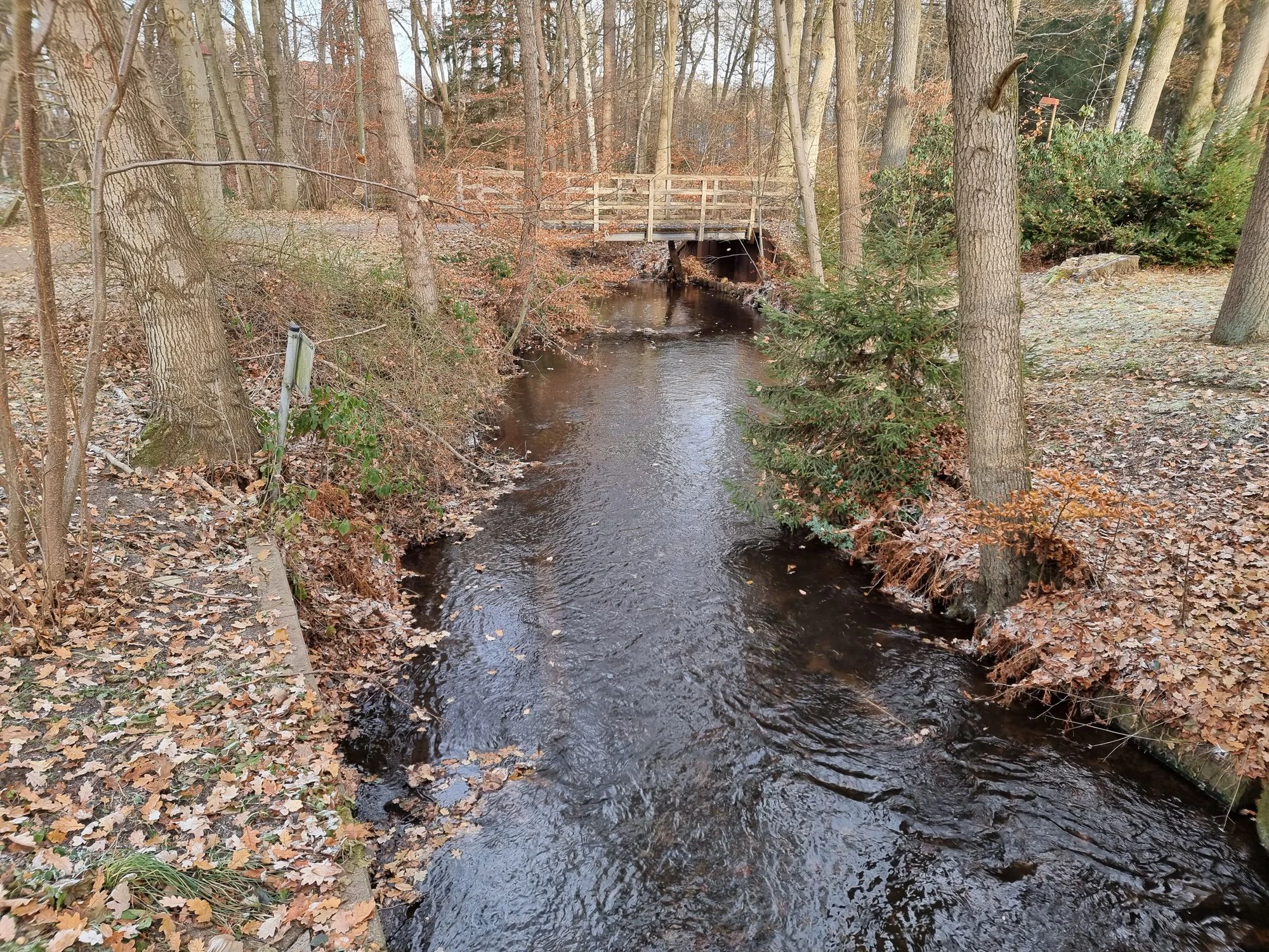
A small, dark stream flowing through a forest with fallen autumn leaves covering the ground, spanned by a simple wooden footbridge in the background.
The Weesener Bach stream flowing through a forested area, crossed by a small footbridge.

Weesener Bach conservation status and protection priorities

Weesener Bach functions as a dedicated habitat and species management area under IUCN Category IV. Its conservation purpose is narrowly defined: to preserve and develop the Weesener Bach stream itself and, through that, to protect the wild plants and animals that depend on it. Within the Celle district's broader protected-area network, the reserve contributes to maintaining the chain of small stream, riparian, and associated woodland habitats that typifies the south Lüneburg Heath landscape and supports regional biodiversity outside the larger, more strictly protected core reserves.

Top sights and standout views in Weesener Bach

The reserve is notable for its tight focus on a single small stream system, the Weesener Bach, which is protected together with the directly surrounding habitats. Its designation as an IUCN Category IV Habitat/Species Management Area reflects a deliberate management approach aimed at conserving specific habitats and species rather than setting land aside as untouched wilderness. The site is integrated into the Celle district's wider pattern of stream, moor, and heathland nature reserves.


Monthly climate preview

Track representative monthly temperature swings and precipitation patterns for Weesener Bach.

Weesener Bach Climate Normals, Long-Term Temperature and Precipitation Rhythm

Long-term NASA measurements establish the baseline monthly temperature and daily precipitation rhythm recorded at a representative coordinate within Weesener Bach. Examining the complete twelve-month dataset clarifies long-term thermal variations and precipitation distribution across the protected area.
Annual mean9 °C
0 °C18 °C
Jan
Feb
Mar
Apr
May13°
Jun16°
Jul18°
Aug18°
Sep14°
Oct
Nov
Dec
Warmest month
July

18.3 °C

Coolest month
January

0.4 °C

Wettest month
July

2.6 mm/day

Driest month
April

1.4 mm/day

Park location guide

Geography guide, regional context, and park location map for Weesener Bach

Weesener Bach park geography, regions, and map view in Germany

Understand where Weesener Bach sits in Germany through a broader geographic reading of the surrounding landscape, nearby location context, and its mapped position within the national park landscape.

How Weesener Bach fits into Germany

Germany is a federal republic in Western and Central Europe with a population of over 83 million across sixteen constituent states. It is Europe's largest economy by nominal GDP and a major global exporter and importer. The capital is Berlin, and the country borders Denmark, Poland, Czech Republic, Austria, Switzerland, France, Luxembourg, Belgium, and the Netherlands.

Wider geography shaping Weesener Bach in Germany

Germany is located in Western and Central Europe, spanning 357,022 km². It borders Denmark to the north, Poland and the Czech Republic to the east, Austria and Switzerland to the south, and France, Luxembourg, Belgium, and the Netherlands to the west. The country has coastlines on the Baltic Sea and North Sea to the north, with the Alps located in the southern region.

Map view of Weesener Bach

Use this park location map to pinpoint Weesener Bach in Germany, understand its exact geographic position, and read its mapped placement within the surrounding landscape more clearly.

Pigeon | © OpenStreetMap contributors

Location context for Weesener Bach

Lower Saxony

Visualizing lowland stream habitats and protected nature reserve terrain

Weesener Bach Photos and Protected Landscape Scenery

Browse detailed Weesener Bach images to observe the protected lowland stream environment and surrounding riparian habitats. Visual reference materials reveal the natural character of the protected landscape within Lower Saxony.

A small, dark stream flowing through a forest with fallen autumn leaves covering the ground, spanned by a simple wooden footbridge in the background.

Park atlas

Discover related nature reserves and regional habitats across the Celle district

Explore Protected Areas and Parks Near Weesener Bach in Lower Saxony

Compare Weesener Bach with other protected landscapes and stream reserves located throughout the surrounding region. Browsing adjacent conservation areas reveals the broader mosaic of wetland and forest habitats native to Lower Saxony.
Nature reserveLandkreis Heidekreis
About 14 km away#1 closest

North

Tal der Kleinen Örtze Nature Reserve: Geographic Atlas and Protected Area Context

Stream valley restoration in the Lüneburg Heath region

An essential look at the Tal der Kleinen Örtze nature reserve, which encompasses restored brook courses and floodplain woodland in Lower Saxony. This protected area serves as a significant example of hydrological recovery and habitat transition, ranging from alder forests to heathland remnants along the valley margins within the broader Heidekreis geography.

Area
4.5 km²
Established
1993
IUCN
IV
Relief
Lowland
Nature reserveNiedersachsen
About 17 km away#2 closest

Northwest

Wietzendorfer Moor: Geographic Analysis of Protected Bog and Wetland Landscapes

Nature reserve terrain in Niedersachsen, Germany

Discover the physical layout of Wietzendorfer Moor, an intricate nature reserve defined by restored raised bog habitats and historical polders. This atlas entry provides geographic context on the wet meadow systems and sand trails that define this unique Lüneburg Heath landscape, highlighting the spatial distribution of its protected parcels.

Area
2.1 km²
Established
1998
IUCN
IV
Relief
Lowland
Nature reserveLower Saxony
About 18 km away#3 closest

Northwest

Wittenmoor Nature Reserve: Geographic Atlas of a Protected Raised Bog in Lower Saxony

Peatland conservation and wetland terrain in the Heidekreis district

Wittenmoor offers a focused view into the peatland dynamics of Lower Saxony. The protected area features two distinct sections characterized by hand-cut peat extraction pools, floating moss mats, and bog-adapted flora. This site provides a clear look at how small-scale reserve management restores hydrological health to marshy meadows and transition-zone moor heath environments within an agricultural landscape.

Area
0.28 km²
Established
1999
IUCN
IV
Relief
Lowland
Nature reserveLandkreis Uelzen
About 29 km away#4 closest

North

Wettenbosteler Moor Protected Area: Geographic Overview and Mapped Landscape Features

A resilient raised bog remnant in the Landkreis Uelzen heath forest

Spanning roughly thirteen hectares, Wettenbosteler Moor preserves a rare spring-fed bog habitat characterized by peat-forming vegetation and pine forest borders. This nature reserve offers deep insights into the drainage networks and lowland terrain of the Lüneburg Heath, mapping the transition between upland forest and valley mire.

Area
0.128 km²
Established
1977
IUCN
IV
Relief
Lowland
Nature reserveLandkreis Uelzen
About 38 km away#5 closest

Northeast

Vogelfreistätte Jastorfer See Nature Reserve in Landkreis Uelzen, Germany

Wetland habitat and river valley protected area

Vogelfreistätte Jastorfer See is a protected wetland landscape located in the Ilmenau valley. This nature reserve, spanning 16.5 hectares, preserves a mosaic of open water and alder swamp forest that sustains diverse bird populations including kingfishers and marsh harriers. It serves as a regionally significant conservation site, embedded within the broader Ilmenautal protected corridor in northern Germany.

Area
0.165 km²
Established
1977
IUCN
IV
Relief
Lowland
Nature reserveLower Saxony
About 38 km away#6 closest

East

Zwergbirkenmoor bei Schafwedel: Protected Bog and Birch Woodland Geography

A rare peatland remnant in the Lower Saxony moorland network.

Zwergbirkenmoor bei Schafwedel is a designated nature reserve that safeguards a small but ecologically significant raised bog remnant. Set amidst the unique salt-dome subsidence landscape of the Lüneburg Heath, the reserve serves as a critical site for studying rare northern birch bog communities and the interaction between groundwater systems and post-salt-dome terrain.

Area
0.027 km²
Established
1950
IUCN
IV
Relief
Lowland
A horizontal watercolor painting depicting a rolling heathland landscape with purple heather, evergreen trees, and a central water feature under a soft sky.
Protected landscapeLower Saxony
About 41 km away#7 closest

North

Naturpark Lüneburger Heide: Protected Landscape Map and Regional Geography

An expansive cultural landscape in northern Lower Saxony

Spanning over 1,000 square kilometers, Naturpark Lüneburger Heide preserves the largest contiguous inland heathlands in Central Europe. Use this atlas resource to understand the park's glacial terrain, including karst sinkholes and natural springs, as well as its status as a model region for sustainable conservation and traditional land management practices.

Area
1,097.85 km²
Established
1922
IUCN
V
Relief
Lowland
Nature reserveUelzen District
About 44 km away#8 closest

Northeast

Vierenbach Nature Reserve: Landscape Geography and Protected Area Mapping in Uelzen District

A study of lowland stream valleys and swamp forest ecosystems.

Vierenbach serves as a crucial lowland stream sanctuary in the Uelzen District, featuring a concentrated variety of alder and ash swamp forests, birch bog woodlands, and wet fen grasslands. This entry offers a deep look into the reserve's unique transition zones between waterlogged valley floors and drier oak-hornbeam Geest slopes.

Area
2.3 km²
Established
2004
IUCN
IV

Common questions about visiting, size, designation, and location context for Weesener Bach

Weesener Bach FAQs for park facts, access, geography, and protected area context

Find quick answers about Weesener Bach, including protected-area facts, park geography, trail and visitor context, and how the park fits into its surrounding country and regional landscape.
MoriAtlas Explorer

Continue Your Protected Areas Search Across the Global Atlas

Deepen your exploration by continuing the structured search for national parks and protected areas worldwide. Utilize the comprehensive filtering capabilities to compare different conservation landscapes and refine your understanding of global park geography. Discover more about the distribution and characteristics of protected natural areas.

Global natural geography