
Mori Atlas logo
Nature reserveTeichfledermausgewässer

A complex mosaic of oxbow lakes, riverine forests, and wetland corridors within the Lower Weser estuary region

Teichfledermausgewässer Nature Reserve and Protected Lowland River Landscapes in Landkreis Cuxhaven

(Naturschutzgebiet Teichfledermausgewässer)

Teichfledermausgewässer represents a protected nature reserve in the district of Cuxhaven, Lower Saxony, where slow-moving lowland rivers and former gravel pits create essential habitats for protected species. The area features a dense network of waters including the Lune and Drepte rivers, providing a critical refuge for pond bats and diverse bird populations across reedbeds, moor woodlands, and tidal floodplains. This geographic overview highlights the structural connectivity of these water-based ecosystems within the broader European Habitats Directive network.

nature reservewetlandlowland riveroxbowlakeclay pit
A flat vector-style illustration of a dramatic canyon scene, featuring tall cliffs, a central waterfall flowing into a river that winds through a forested valley under a soft sun.

Teichfledermausgewässer

Nature reserve

Park overview

Structured park overview, official facts, and landscape profile for Teichfledermausgewässer

Teichfledermausgewässer park facts, protected area profile, and essential visitor context

Review the core facts for Teichfledermausgewässer, including designation, size, terrain, visitor scale, habitats, and operating context in one park-focused overview.

About Teichfledermausgewässer

Teichfledermausgewässer is a comparatively recent but ecologically focused nature reserve in northern Lower Saxony. It lies in the Landkreis Cuxhaven, spanning parts of the municipalities of Loxstedt, Hagen im Bremischen and Beverstedt, and covers a transitional landscape between the industrial port city of Bremerhaven and the larger city of Bremen. The reserve was formally designated on 21 December 2018 under the identifier NSG LÜ 344 and covers around 633 hectares, making it one of the more substantial wetland reserves in this part of the Weser floodplain.

Although the reserve's name translates roughly as "pond bat waters", it is not a single lake. Instead, it is a mosaic of flowing and standing waters: the lower Lune and its old arms; the Drepte from Wulsbüttel to its tidal sluice at Drepter Siel; the Gackau near Wittstedt; the Aschwardener Flutgraben; and a cluster of standing waters including the Stoteler See and many former clay extraction pits, locally called Pütten. The Stoteler See originated from sand and gravel extraction, whereas the smaller pits were created by digging Klei, a heavy clay historically used for dike construction.

The site lies within the broader Habitats Directive area "Teichfledermausgewässer im Raum Bremerhaven/Bremen" and overlaps with the EU Birds Directive site "Unterweser" along the Right Side Channel of the Weser. It connects ecologically to the neighbouring nature reserve "Teichfledermausgewässer in der Gemeinde Schwanewede" via the protected area "Unterwesermarsch", and touches the "Tideweser" reserve in the southwest. This network of overlapping designations reflects the site's importance for bat, otter, fish and waterbird conservation in one of Lower Saxony's most intensively used lowland landscapes, where intensive agriculture, transportation infrastructure and tidal influence all meet.

The reserve's management, led by the lower nature conservation authority of Landkreis Cuxhaven, centres on maintaining intact water margins, retaining the hydrology of the slow-flowing rivers, and protecting the wooded and reed-fringed transitions between water and land. Its 10-metre-wide water margin strips are explicitly included in the protection area, underscoring how shoreline habitat is treated as functionally inseparable from the water itself.

Quick facts and research context for Teichfledermausgewässer

Teichfledermausgewässer is a nature reserve in the Landkreis Cuxhaven, Lower Saxony, designated on 21 December 2018 under the code NSG LÜ 344 and covering roughly 633 hectares. The site stretches along several lowland rivers and canals between Bremerhaven and Bremen, including the Lune, Drepte, Gackau and Aschwardener Flutgraben, as well as the Stoteler See lake and numerous former clay pits (Pütten) in the Osterstader Marsch.

It forms part of the EU Habitats Directive site "Teichfledermausgewässer im Raum Bremerhaven/Bremen" and overlaps with the EU Birds Directive site "Unterweser" along the Weser's Right Side Channel. Its defining ecological focus is the conservation of waterways that support the pond bat, otter, native fish and lamprey species, and a rich community of breeding and migratory waterbirds. The responsible lower nature conservation authority is the Landkreis Cuxhaven.

Protection and recognition

Documented protected area designation, management scope, and recognition data

Teichfledermausgewässer Protection Status and International Recognition

Teichfledermausgewässer protection status details bring together documented designation records and international recognition sources for conservation analysis. Structured protected area data outlines management scope and official boundaries across the protected landscape.

Protection details

WDPA ID
555690909
Park context

Deeper park guide and search-rich context for Teichfledermausgewässer

Teichfledermausgewässer history, landscape, wildlife, and travel context

Explore Teichfledermausgewässer through its history, landscape character, ecosystems, wildlife, conservation priorities, cultural context, and seasonal travel timing in a structured park guide built for atlas discovery and search intent.

Why Teichfledermausgewässer stands out

The reserve is best known for protecting a connected network of still and slow-flowing waters that serve as feeding habitat for the pond bat (Teichfledermaus), one of Europe's rarest bat species. It combines oxbow stretches, lowland rivers, reed-fringed former clay pits and the Stoteler See with adjacent brook and moor woodlands, creating a rare lowland water-landscape mosaic in the Weser estuary region.
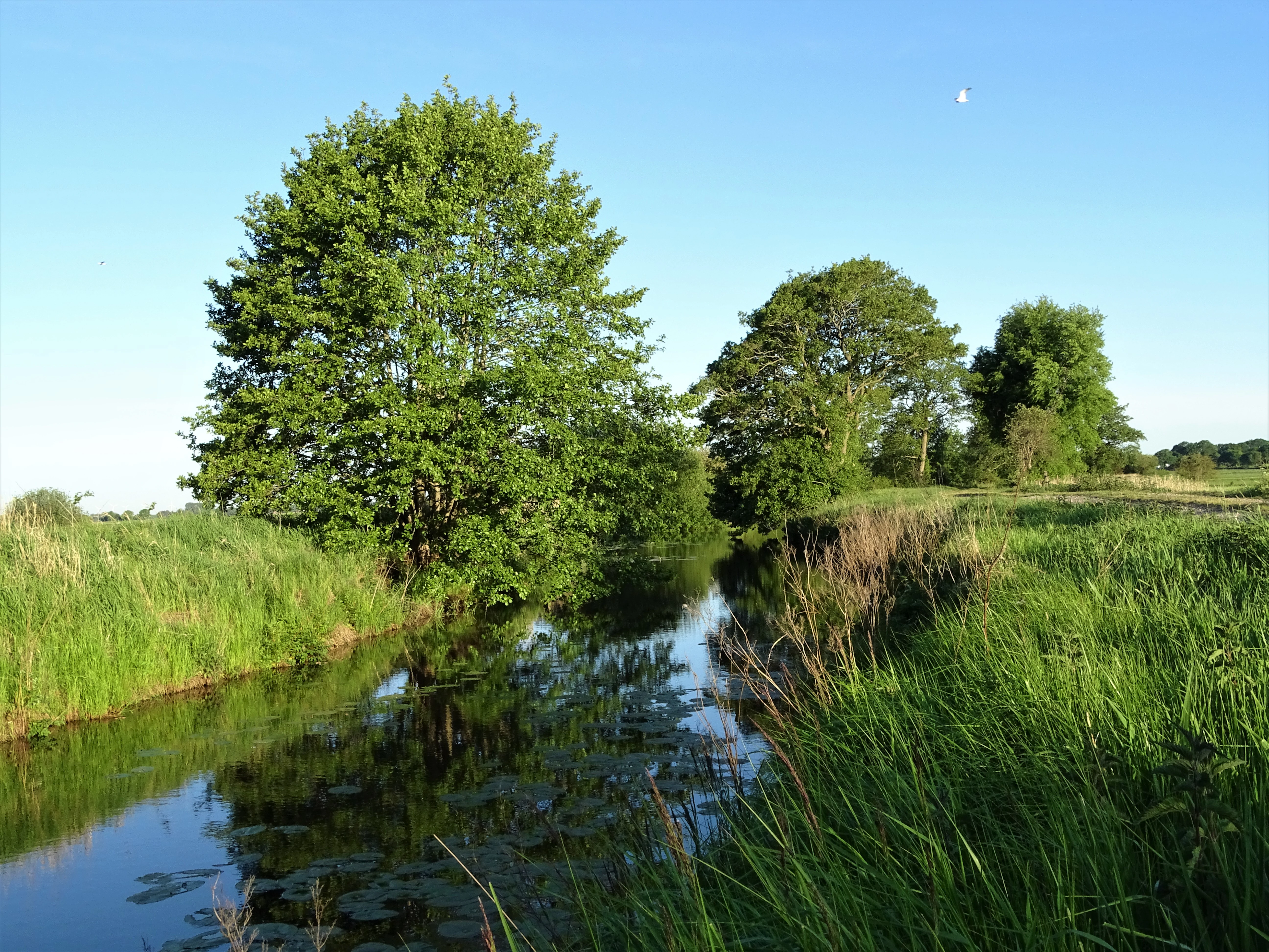
A narrow, calm stream winds through lush green riparian vegetation and deciduous trees under a clear blue sky.
Riparian vegetation along the Flutgraben stream within the Teichfledermausgewässer nature reserve.

Teichfledermausgewässer history and protected-area timeline

The reserve is comparatively young in formal terms, having been placed under nature protection on 21 December 2018. Its establishment followed the long-running identification of the Lune, Drepte, Gackau and Aschwardener Flutgraben systems, together with the Stoteler See and various former clay pits, as a coherent functional habitat complex for the pond bat and associated wetland species.

The reserve was designed to anchor a portion of the larger EU Habitats Directive site "Teichfledermausgewässer im Raum Bremerhaven/Bremen" in national protection law in Germany. Its boundaries were drawn to align with the corresponding Schutzgebiete in the Landkreis Osterholz, particularly the nature reserve "Teichfledermausgewässer in der Gemeinde Schwanewede", linked through the Unterwesermarsch reserve. Many of the standing waters included in the area are not natural features but legacies of earlier industrial activity: sand, gravel and especially Klei extraction for dike building shaped much of the modern hydrology that the reserve now protects. Designation in 2018 brought these formerly exploited basins, along with their developing reed and woodland communities, under a unified conservation regime administered by Landkreis Cuxhaven.

Teichfledermausgewässer landscape and geographic character

The landscape of Teichfledermausgewässer is a lowland mosaic shaped by rivers of modest gradient, by tidal influences from the Weser, and by centuries of human modification through drainage, dike construction and clay extraction. The Lune enters the reserve near Beverstedt as a slow, meandering lowland river, fringed by tall herb communities, reedbeds and small patches of brook forest, with several old arms and the Alte Lune loop providing added structural complexity. The Drepte, in contrast, runs in its upper course through a relatively natural floodplain with brook forests, floodplain woodland remnants, reedbeds and pastures around Wulsbüttel and Hagen im Bremischen; downstream of the A27 motorway crossing it traverses the Osterstader Marsch, where it is diked and bordered by grazed foreshore areas.

The Gackau and Aschwardener Flutgraben add further linear water features winding through agricultural land, with banks dominated by tall herb vegetation, reed fringes, ruderal communities and, in places, narrow strips of river woodland and brook forest. Among the still waters, the Stoteler See stands out for its size: it occupies a former gravel and sand extraction site and is bordered by reed, willow scrub and adjacent brook and deciduous woodland. Smaller former Klei pits, the so-called Pütten, are scattered across the Osterstader Marsch; those lying in the southern part of the reserve within the older Weser flood zone are particularly dynamic, with reed-fringed banks and ongoing ecological succession toward scrub and woodland.

Teichfledermausgewässer ecosystems, habitats, and plant life

Ecologically, Teichfledermausgewässer is defined by the close interplay of various water bodies and their margins. Slow-flowing stretches of river, oxbows and clay pits support extensive reedbeds, tall herb flood meadows, periodically flooded wet grasslands in the Drepte lower course, and structurally diverse shorelines with willows and other woody species. Brook forest (Bruchwald) and floodplain woodland remnants line parts of the Lune and the upper Drepte, while pockets of moor forest (Moorwald) and deciduous woodland occur near Wulsbüttel.

Aquatic and semi-aquatic habitats are unusually varied for a protected area of this size. The still waters and old arms host well-developed aquatic and emergent vegetation, including pondweed stands and frogbit communities, together with characteristic reed and sedge zones. Wetland fringes with reed, sedge and tall herbs connect water bodies to meadows and pastures, creating a gradient from open water to seasonally flooded grassland that is typical of intact Weser marshland conditions. Land use within the reserve is intentionally low-intensity, with extensive grasslands and pastures keeping nutrient inputs and disturbance modest compared with the surrounding intensively farmed lowlands.

Teichfledermausgewässer wildlife and species highlights

Wildlife is the most distinctive aspect of this reserve. Its naming species, the pond bat (Teichfledermaus, Myotis dasycneme), hunts over the still and slow-moving waters and depends on the smooth, insect-rich water surfaces and hedge-lined surroundings maintained here. The rivers, oxbows and clay pits are also important for the Eurasian otter (Fischotter) and for a range of fish and lampreys, including the bitterling and both brook and river lampreys, which require clean gravel beds and clean water.

The waters and adjacent marshland support a rich bird community. Breeding species include marsh harrier, water rail, corncrake, redshank, Savi's warbler, sedge warbler, bluethroat and whinchat, with white stork using the area as a feeding habitat. Outside the breeding season the site functions as an important resting and foraging area for whooper swan, barnacle goose, greater white-fronted goose, great black-backed gull, black-headed gull, pied avocet, northern lapwing, northern shoveler and Eurasian wigeon, particularly around the Pütten in the southern, seasonally flooded part of the reserve.

Teichfledermausgewässer conservation status and protection priorities

The reserve's central conservation rationale is the protection of a coherent network of ponds, oxbows and slow-flowing rivers that maintain functioning populations of the pond bat and other wetland-dependent species. Its designation under the German Naturschutzrecht and its embedment within the larger EU Habitats Directive site "Teichfledermausgewässer im Raum Bremerhaven/Bremen" give it significance beyond purely national protection. Along the Right Side Channel of the Weser, the site additionally overlaps with the EU Birds Directive area "Unterweser", which strengthens its formal role in safeguarding breeding, resting and foraging habitat for waterbirds listed under European nature law.

The reserve's design explicitly incorporates 10-metre-wide water margin strips and includes adjacent semi-natural lowlands such as brook forests, moor woodland fragments, reedbeds and extensive wet grasslands, recognising that the value of the waters for bats, otters, fish and birds depends on intact shoreline and floodplain habitat. By linking, via the Unterwesermarsch reserve, to the adjoining Teichfledermausgewässer reserve in Schwanewede and reaching the Tideweser reserve on its southwestern edge, it forms a key node in a much larger ecological corridor along the Lower Weser. It is administered by the lower nature conservation authority of Landkreis Cuxhaven under code NSG LÜ 344 and is registered internationally in the World Database on Protected Areas.

Teichfledermausgewässer cultural meaning and human context

Culturally, the area sits within the historic Weser marshland, a region whose identity has been shaped over centuries by the struggle against tidal flooding and the need to build and maintain dikes. The presence of numerous former Klei pits reflects this history: the heavy clay used for dike construction was dug directly from the marshes, leaving a legacy of small water bodies that today have become biodiversity hotspots rather than scars of exploitation. Settlements such as Loxstedt, Hagen im Bremischen and Beverstedt, along with smaller places like Wittstedt, Wulsbüttel and Uthlede, define the rural character of the landscape and form the administrative backdrop against which the reserve operates. Traditional low-intensity land uses, especially pasture and hay meadow management on the floodplain grasslands, are part of what keeps parts of this intensively farmed region open, diverse and ecologically valuable.

Top sights and standout views in Teichfledermausgewässer

The reserve combines a rare concentration of slow-moving lowland rivers, oxbows and former clay pits in one protected area, providing the open water and calm, insect-rich surfaces that pond bats need as hunting grounds. It anchors an important part of the EU Habitats Directive network in the Lower Weser region and links formally to several neighbouring reserves, creating a continuous conservation corridor.

Its birdlife is unusually varied for a small area, with marsh harrier, corncrake, water rail and bluethroat breeding in reed and wet grassland habitats, while the southern Pütten in the older Weser flood zone draw large flocks of geese, swans, waders and ducks outside the breeding season. The presence of otter and of sensitive fish such as bitterling and Europe's two native lampreys underscores the ecological integrity of its water bodies.

Best time to visit Teichfledermausgewässer

The reserve is not primarily developed for tourism, and visitors should treat it as a quiet protected landscape best appreciated on foot or by bicycle along public paths. Late spring and early summer are particularly rewarding for seeing breeding marshland birds such as marsh harrier, reed warblers and bluethroat in full activity, while the wet grasslands and reed edges are at their most lush. Winter and early spring bring large numbers of swans, geese and ducks to the open water and the seasonally flooded clay pits in the south, when flocks of whooper swan, white-fronted goose and various duck species concentrate around the Pütten; however, wet, exposed lowland conditions and limited accessible paths can make visits harder at that time of year.

Monthly climate preview

Long-term representative point measurements for monthly temperature and precipitation.

Teichfledermausgewässer Climate Normals and Annual Temperature Rhythm

Representative coordinate records show mean monthly temperatures ranging from 1.21 degrees Celsius in January to 17.88 degrees Celsius in July alongside steady precipitation. Examining the full twelve-month dataset reveals detailed seasonal shifts across the protected area.
Annual mean9 °C
1 °C18 °C
Jan
Feb
Mar
Apr
May12°
Jun16°
Jul18°
Aug18°
Sep14°
Oct10°
Nov
Dec
Warmest month
July

17.9 °C

Coolest month
January

1.2 °C

Wettest month
July

2.6 mm/day

Driest month
April

1.4 mm/day

Park location guide

Geography guide, regional context, and park location map for Teichfledermausgewässer

Teichfledermausgewässer park geography, regions, and map view in Germany

Understand where Teichfledermausgewässer sits in Germany through a broader geographic reading of the surrounding landscape, nearby location context, and its mapped position within the national park landscape.

How Teichfledermausgewässer fits into Germany

Germany is a federal republic in Western and Central Europe with a population of over 83 million across sixteen constituent states. It is Europe's largest economy by nominal GDP and a major global exporter and importer. The capital is Berlin, and the country borders Denmark, Poland, Czech Republic, Austria, Switzerland, France, Luxembourg, Belgium, and the Netherlands.

Wider geography shaping Teichfledermausgewässer in Germany

Germany is located in Western and Central Europe, spanning 357,022 km². It borders Denmark to the north, Poland and the Czech Republic to the east, Austria and Switzerland to the south, and France, Luxembourg, Belgium, and the Netherlands to the west. The country has coastlines on the Baltic Sea and North Sea to the north, with the Alps located in the southern region.

Map view of Teichfledermausgewässer

Use this park location map to pinpoint Teichfledermausgewässer in Germany, understand its exact geographic position, and read its mapped placement within the surrounding landscape more clearly.

Pigeon | © OpenStreetMap contributors

Location context for Teichfledermausgewässer

Landkreis CuxhavenNiedersachsen

Visualizing the lowland rivers, reedbeds, and protected water habitats

Teichfledermausgewässer Photos and Landscape Scenery

Visual documentation captures the complex mosaic of slow-moving lowland rivers, oxbow lakes, and wetland margins that define the nature reserve. Detailed photography reveals the specific ecological structure of the protected waterways and surrounding riparian terrain.

A narrow, calm stream winds through lush green riparian vegetation and deciduous trees under a clear blue sky.

Park atlas

Compare adjacent wetland reserves and connected Lower Weser conservation corridors

Explore Protected Areas and Parks Near Teichfledermausgewässer

Browsing other parks near Teichfledermausgewässer reveals connected wetland reserves and lowland river habitats across the Lower Weser region. Comparing adjacent protected areas provides broader geographic context for regional floodplain ecosystems and water bird refuges.
Nature reserveLower Saxony
About 6.4 km away#1 closest

West

Strohauser Vorländer und Plate Nature Reserve: Geography and Protected Area Atlas

Tidal wetlands and freshwater habitats in Lower Saxony

The Strohauser Vorländer und Plate nature reserve protects a expansive tidal floodplain characterized by its river island geography, slow-moving side arms, and seasonal inundation patterns. As a focal point for meadow-bird monitoring, this site offers a clear view into the ecological dynamics of the Lower Weser river landscape, showcasing a rare combination of summer-dike-protected meadows and open freshwater tidal flats.

Area
11.52 km²
Established
2007
IUCN
IV
A soft, light-toned watercolor painting of a wetland landscape featuring green fields, a small path, a line of trees, and a distant low hill.
Nature reserveBremen
About 8.6 km away#2 closest

North

Luneplate Nature Reserve: A Detailed Geographic Atlas of Bremen's Coastal Wetland Landscapes

Protected estuarine habitats and tidal geography in the Weser river basin

Luneplate Nature Reserve offers a rich study of coastal wetland geography. Spanning the interface between the Weser river and the North Sea, the reserve features extensive mudflats, saltmarshes, and reedbeds. This protected landscape serves as an essential migratory hub, providing habitat for diverse waterbird populations within the maritime environment of Bremerhaven.

Area
14.38 km²
Established
2015
IUCN
IV
Nature reserveLower Saxony
About 9.1 km away#3 closest

Southeast

Südliches Hagener Königsmoor Nature Reserve: A Protected Peatland in Lower Saxony

Ecological mosaic of bog woodland and historical peat cuttings

Südliches Hagener Königsmoor is a protected nature reserve in Hagen im Bremischen, Lower Saxony. The terrain features a distinct mosaic of raised bog vegetation, drainage channels, and water-filled peat cuttings that anchor a rare remnant of the original lowland moor landscape against modern agricultural surroundings.

Area
0.85 km²
Established
1981
IUCN
IV
Protected landscapeNiedersachsen
About 11 km away#4 closest

Southwest

Dornebbe, Braker Sieltief und Colmarer Tief: Mapped Protected Landscape in Niedersachsen

Geographic atlas of tidal lowland waterways and coastal habitats

Dornebbe, Braker Sieltief und Colmarer Tief comprises a chain of slow-flowing streams and bank habitats essential to the coastal marshland geography of Niedersachsen. The area provides a structured look at multi-layered habitat protection, featuring dense reedbeds and aquatic corridors vital for regional biodiversity in the German tidal zone.

Area
0.33 km²
Established
2018
A soft watercolor painting featuring a reflective water surface, grassy marshland in the foreground, a tree line in the midground, and rolling, misty hills in the background.
Nature reserveBremen
About 13 km away#5 closest

North

Düllhamm Nature Reserve: Protected Lowland Mosaic in Bremerhaven

Mapping the transitional forest and marshland terrain of Bremen.

Covering a small footprint, Düllhamm remains a vital nature reserve representing the lowland ecosystems of northern Germany. The area maps a unique gradient of dry oak-birch woodland shifting into wet meadows, boggy heath, and reed-covered marshes. This protected landscape offers a concentrated look at regional ecological patterns within the urbanized landscape of the Bremerhaven district.

Area
0.043 km²
Established
1984
Relief
Lowland
Climate
Temperate
Watercolor painting showing coastal wetlands with mudflats, salt marshes, and distant hills under a soft light
National parkLower Saxony
About 15 km away#6 closest

Northwest

Lower Saxon Wadden Sea National Park: Protected Coastal Landscape & Geography Atlas

Explore mapped boundaries, intertidal zones, and Lower Saxony's natural terrain.

Delve into the Lower Saxon Wadden Sea National Park, a significant national park situated in Lower Saxony, Germany. This page serves as your atlas entry point for understanding its protected landscape, characterized by vast mudflats, salt marshes, and a crucial role as a migratory bird corridor. Discover the geographic context of this UNESCO World Heritage site and its unique intertidal ecosystem through structured map data and detailed landscape information.

Area
345.8 km²
Established
1986
IUCN
II
Relief
Lowland
Nature reserveLower Saxony
About 21 km away#7 closest

East

Wollingster See und Randmoore: A Detailed Map and Geography of This Lower Saxony Nature Reserve

Examining the intersection of glacial lake basins and bog restoration efforts

Wollingster See und Randmoore protects a critical intersection of aquatic and terrestrial ecosystems within Lower Saxony. Learn about the reserve's formation as a potential pingo or glacial pothole, its distinct water quality, and the ongoing efforts to restore its surrounding raised-bog and moor-heath landscape through traditional grazing and rewetting.

Area
1.17 km²
Established
1932
IUCN
IV
Relief
Lowland
A horizontal watercolor painting depicting a soft-focus landscape with a pond in the foreground, pink and green heath vegetation, and distant tree lines under a pale sky.
Nature reserveBremen
About 22 km away#8 closest

South

Eispohl, Sandwehen und Heideweiher: Protected Landscape and Geest Geography

Nature reserve featuring historic dunes and heath pond networks

This nature reserve in Bremen protects a remnant of the Rekumer Geest, featuring a complex of inland dunes, wet heath, and small heath ponds. Through its combination of extensively grazed grasslands and mixed forests, the area serves as a vital habitat corridor, maintaining the traditional Geest landscape patterns that once dominated the region between Bremen and the lower Weser.

Area
0.036 km²
Established
1988
Relief
Lowland
Climate
Temperate

Common questions about visiting, size, designation, and location context for Teichfledermausgewässer

Teichfledermausgewässer FAQs for park facts, access, geography, and protected area context

Find quick answers about Teichfledermausgewässer, including protected-area facts, park geography, trail and visitor context, and how the park fits into its surrounding country and regional landscape.
MoriAtlas Explorer

Continue Your Protected Areas Search Across the Global Atlas

Deepen your exploration by continuing the structured search for national parks and protected areas worldwide. Utilize the comprehensive filtering capabilities to compare different conservation landscapes and refine your understanding of global park geography. Discover more about the distribution and characteristics of protected natural areas.

Global natural geography