
Why Teichfledermausgewässer stands out
The reserve is best known for protecting a connected network of still and slow-flowing waters that serve as feeding habitat for the pond bat (Teichfledermaus), one of Europe's rarest bat species. It combines oxbow stretches, lowland rivers, reed-fringed former clay pits and the Stoteler See with adjacent brook and moor woodlands, creating a rare lowland water-landscape mosaic in the Weser estuary region.
Teichfledermausgewässer history and protected-area timeline
The reserve is comparatively young in formal terms, having been placed under nature protection on 21 December 2018. Its establishment followed the long-running identification of the Lune, Drepte, Gackau and Aschwardener Flutgraben systems, together with the Stoteler See and various former clay pits, as a coherent functional habitat complex for the pond bat and associated wetland species.
The reserve was designed to anchor a portion of the larger EU Habitats Directive site "Teichfledermausgewässer im Raum Bremerhaven/Bremen" in national protection law in Germany. Its boundaries were drawn to align with the corresponding Schutzgebiete in the Landkreis Osterholz, particularly the nature reserve "Teichfledermausgewässer in der Gemeinde Schwanewede", linked through the Unterwesermarsch reserve. Many of the standing waters included in the area are not natural features but legacies of earlier industrial activity: sand, gravel and especially Klei extraction for dike building shaped much of the modern hydrology that the reserve now protects. Designation in 2018 brought these formerly exploited basins, along with their developing reed and woodland communities, under a unified conservation regime administered by Landkreis Cuxhaven.
Teichfledermausgewässer landscape and geographic character
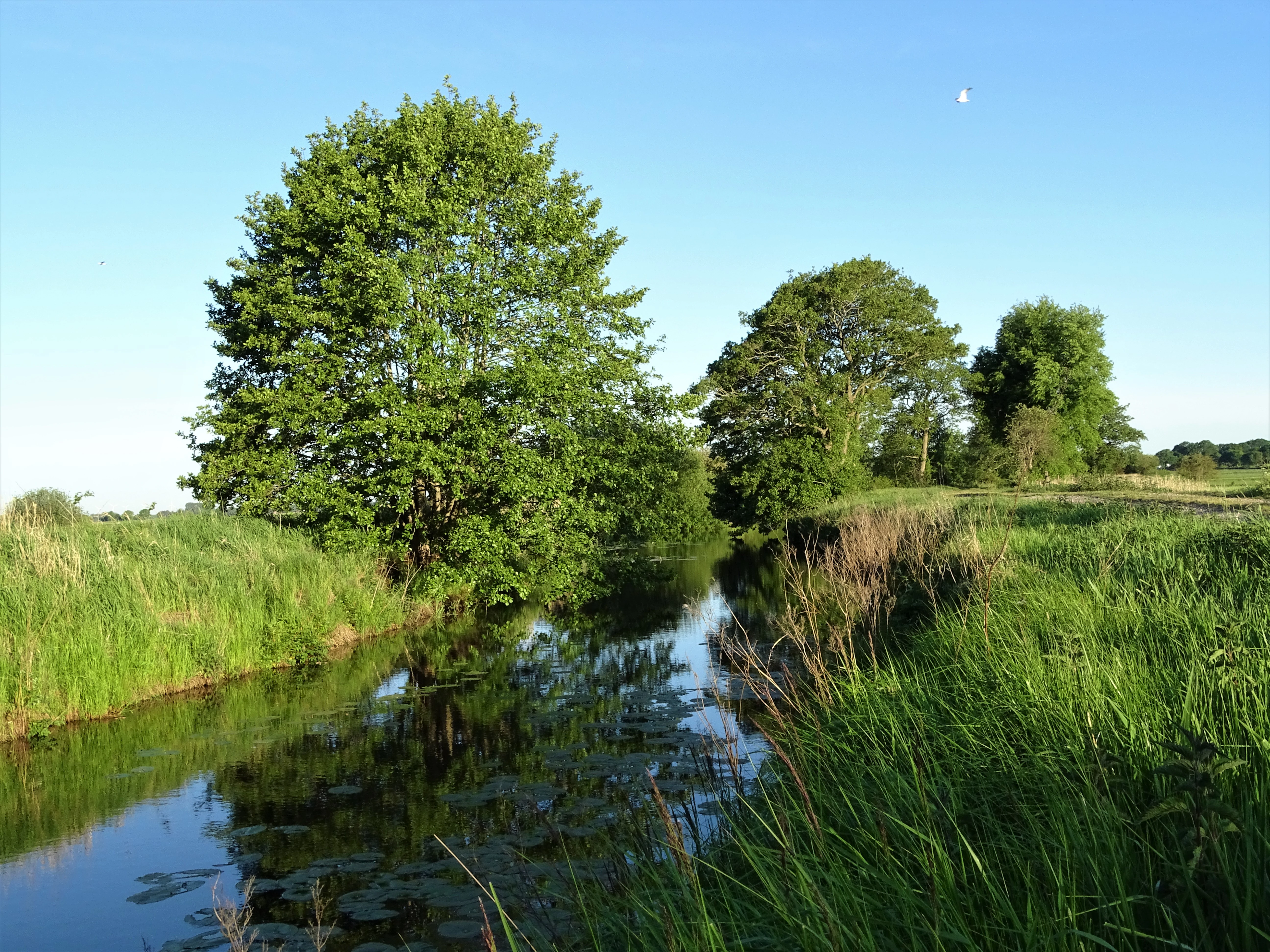
The landscape of Teichfledermausgewässer is a lowland mosaic shaped by rivers of modest gradient, by tidal influences from the Weser, and by centuries of human modification through drainage, dike construction and clay extraction. The Lune enters the reserve near Beverstedt as a slow, meandering lowland river, fringed by tall herb communities, reedbeds and small patches of brook forest, with several old arms and the Alte Lune loop providing added structural complexity. The Drepte, in contrast, runs in its upper course through a relatively natural floodplain with brook forests, floodplain woodland remnants, reedbeds and pastures around Wulsbüttel and Hagen im Bremischen; downstream of the A27 motorway crossing it traverses the Osterstader Marsch, where it is diked and bordered by grazed foreshore areas.
The Gackau and Aschwardener Flutgraben add further linear water features winding through agricultural land, with banks dominated by tall herb vegetation, reed fringes, ruderal communities and, in places, narrow strips of river woodland and brook forest. Among the still waters, the Stoteler See stands out for its size: it occupies a former gravel and sand extraction site and is bordered by reed, willow scrub and adjacent brook and deciduous woodland. Smaller former Klei pits, the so-called Pütten, are scattered across the Osterstader Marsch; those lying in the southern part of the reserve within the older Weser flood zone are particularly dynamic, with reed-fringed banks and ongoing ecological succession toward scrub and woodland.
Teichfledermausgewässer ecosystems, habitats, and plant life
Ecologically, Teichfledermausgewässer is defined by the close interplay of various water bodies and their margins. Slow-flowing stretches of river, oxbows and clay pits support extensive reedbeds, tall herb flood meadows, periodically flooded wet grasslands in the Drepte lower course, and structurally diverse shorelines with willows and other woody species. Brook forest (Bruchwald) and floodplain woodland remnants line parts of the Lune and the upper Drepte, while pockets of moor forest (Moorwald) and deciduous woodland occur near Wulsbüttel.
Aquatic and semi-aquatic habitats are unusually varied for a protected area of this size. The still waters and old arms host well-developed aquatic and emergent vegetation, including pondweed stands and frogbit communities, together with characteristic reed and sedge zones. Wetland fringes with reed, sedge and tall herbs connect water bodies to meadows and pastures, creating a gradient from open water to seasonally flooded grassland that is typical of intact Weser marshland conditions. Land use within the reserve is intentionally low-intensity, with extensive grasslands and pastures keeping nutrient inputs and disturbance modest compared with the surrounding intensively farmed lowlands.
Teichfledermausgewässer wildlife and species highlights
Wildlife is the most distinctive aspect of this reserve. Its naming species, the pond bat (Teichfledermaus, Myotis dasycneme), hunts over the still and slow-moving waters and depends on the smooth, insect-rich water surfaces and hedge-lined surroundings maintained here. The rivers, oxbows and clay pits are also important for the Eurasian otter (Fischotter) and for a range of fish and lampreys, including the bitterling and both brook and river lampreys, which require clean gravel beds and clean water.
The waters and adjacent marshland support a rich bird community. Breeding species include marsh harrier, water rail, corncrake, redshank, Savi's warbler, sedge warbler, bluethroat and whinchat, with white stork using the area as a feeding habitat. Outside the breeding season the site functions as an important resting and foraging area for whooper swan, barnacle goose, greater white-fronted goose, great black-backed gull, black-headed gull, pied avocet, northern lapwing, northern shoveler and Eurasian wigeon, particularly around the Pütten in the southern, seasonally flooded part of the reserve.
Teichfledermausgewässer conservation status and protection priorities
The reserve's central conservation rationale is the protection of a coherent network of ponds, oxbows and slow-flowing rivers that maintain functioning populations of the pond bat and other wetland-dependent species. Its designation under the German Naturschutzrecht and its embedment within the larger EU Habitats Directive site "Teichfledermausgewässer im Raum Bremerhaven/Bremen" give it significance beyond purely national protection. Along the Right Side Channel of the Weser, the site additionally overlaps with the EU Birds Directive area "Unterweser", which strengthens its formal role in safeguarding breeding, resting and foraging habitat for waterbirds listed under European nature law.
The reserve's design explicitly incorporates 10-metre-wide water margin strips and includes adjacent semi-natural lowlands such as brook forests, moor woodland fragments, reedbeds and extensive wet grasslands, recognising that the value of the waters for bats, otters, fish and birds depends on intact shoreline and floodplain habitat. By linking, via the Unterwesermarsch reserve, to the adjoining Teichfledermausgewässer reserve in Schwanewede and reaching the Tideweser reserve on its southwestern edge, it forms a key node in a much larger ecological corridor along the Lower Weser. It is administered by the lower nature conservation authority of Landkreis Cuxhaven under code NSG LÜ 344 and is registered internationally in the World Database on Protected Areas.
Teichfledermausgewässer cultural meaning and human context
Culturally, the area sits within the historic Weser marshland, a region whose identity has been shaped over centuries by the struggle against tidal flooding and the need to build and maintain dikes. The presence of numerous former Klei pits reflects this history: the heavy clay used for dike construction was dug directly from the marshes, leaving a legacy of small water bodies that today have become biodiversity hotspots rather than scars of exploitation. Settlements such as Loxstedt, Hagen im Bremischen and Beverstedt, along with smaller places like Wittstedt, Wulsbüttel and Uthlede, define the rural character of the landscape and form the administrative backdrop against which the reserve operates. Traditional low-intensity land uses, especially pasture and hay meadow management on the floodplain grasslands, are part of what keeps parts of this intensively farmed region open, diverse and ecologically valuable.
Top sights and standout views in Teichfledermausgewässer
The reserve combines a rare concentration of slow-moving lowland rivers, oxbows and former clay pits in one protected area, providing the open water and calm, insect-rich surfaces that pond bats need as hunting grounds. It anchors an important part of the EU Habitats Directive network in the Lower Weser region and links formally to several neighbouring reserves, creating a continuous conservation corridor.
Its birdlife is unusually varied for a small area, with marsh harrier, corncrake, water rail and bluethroat breeding in reed and wet grassland habitats, while the southern Pütten in the older Weser flood zone draw large flocks of geese, swans, waders and ducks outside the breeding season. The presence of otter and of sensitive fish such as bitterling and Europe's two native lampreys underscores the ecological integrity of its water bodies.
Best time to visit Teichfledermausgewässer
The reserve is not primarily developed for tourism, and visitors should treat it as a quiet protected landscape best appreciated on foot or by bicycle along public paths. Late spring and early summer are particularly rewarding for seeing breeding marshland birds such as marsh harrier, reed warblers and bluethroat in full activity, while the wet grasslands and reed edges are at their most lush. Winter and early spring bring large numbers of swans, geese and ducks to the open water and the seasonally flooded clay pits in the south, when flocks of whooper swan, white-fronted goose and various duck species concentrate around the Pütten; however, wet, exposed lowland conditions and limited accessible paths can make visits harder at that time of year.