

Mori Atlas logo
Marine protected areaThunder Bay National Marine Sanctuary

Understanding the geography and protected aquatic boundaries of this Great Lakes sanctuary

Thunder Bay National Marine Sanctuary: A Mapped Exploration of Underwater Maritime Heritage

(Thunder Bay National Marine Sanctuary and Underwater Preserve)

Thunder Bay National Marine Sanctuary protects 4,300 square miles of cold, freshwater terrain within Lake Huron off the coast of Michigan. This underwater landscape preserves a vast collection of historic shipwrecks, providing a tangible window into two centuries of maritime activity. The sanctuary maps a complex submerged geography where glacial formations meet deep basins and shoals, creating a unique environment for both ecological study and archaeological documentation.

national marine sanctuaryGreat LakesLake Huronshipwrecksunderwater heritagemaritime archaeology

Thunder Bay National Marine Sanctuary

Marine protected area

Park overview

Structured park overview, official facts, and landscape profile for Thunder Bay National Marine Sanctuary

Thunder Bay National Marine Sanctuary park facts, protected area profile, and essential visitor context

Review the core facts for Thunder Bay National Marine Sanctuary, including designation, size, terrain, visitor scale, habitats, and operating context in one park-focused overview.

About Thunder Bay National Marine Sanctuary

Thunder Bay National Marine Sanctuary is a large federally protected aquatic reserve in Lake Huron, located along the northeastern shore of Michigan's Lower Peninsula. Its territory stretches from the western edge of Presque Isle County to the southern edge of Alcona County and extends east across the lake to the international boundary with Canada, placing it at a critical crossroads of Great Lakes geography. The sanctuary is administered jointly by the National Oceanic and Atmospheric Administration, a federal agency, and the Michigan Department of Natural Resources, reflecting a partnership between national and state stewardship.

The defining character of the sanctuary is its underwater cultural landscape. Beneath its cold, relatively clear freshwater lie the remains of more than a hundred known shipwrecks, ranging from nineteenth-century wooden paddle steamers to twentieth-century steel-hulled steamers and package freighters. These wrecks together tell the story of bulk freight, passenger movement, and resource extraction across the upper Great Lakes during a period in which the region was a major engine of American industrial growth. The sanctuary's protection framework is built around the idea that these sites are not merely curiosities but a coherent historical archive that deserves long-term, formal conservation just as much as a terrestrial historic district would.

Beyond its cultural significance, the sanctuary is a substantial freshwater environment in its own right. The waters of Thunder Bay and the deep offshore zone that was added in the 2014 boundary expansion provide habitat for Great Lakes fish populations and contribute to the broader ecological health of Lake Huron. The combination of historical, ecological, and interpretive value is what makes the site unique among American protected areas: a place where maritime archaeology, freshwater ecology, and public education converge in a single designated landscape.

The visitor experience of the sanctuary is anchored by the Great Lakes Maritime Heritage Center in Alpena, which overlooks the Thunder Bay River near where it meets Lake Huron. The center houses exhibits on local shipwrecks and Great Lakes history, an auditorium, an archaeological conservation laboratory where recovered artifacts are stabilized and studied, and education areas designed to connect the public with the underwater resources of the sanctuary. Together, the marine zone and the heritage center form an integrated experience that links the surface and the depths of Thunder Bay.

Quick facts and research context for Thunder Bay National Marine Sanctuary

Thunder Bay National Marine Sanctuary is a United States National Marine Sanctuary located in Lake Huron along the northeastern Michigan coast. It was established on June 22, 2000, and is jointly administered by the National Oceanic and Atmospheric Administration and the Michigan Department of Natural Resources.

The sanctuary includes the waters of Thunder Bay and an expanded offshore zone that extends east to the Canada-United States border. It preserves an estimated 116 historically significant shipwrecks dating from the nineteenth and twentieth centuries. The nearby city of Alpena serves as the main regional hub, and the Great Lakes Maritime Heritage Center in Alpena functions as the primary visitor and interpretive facility.

Protection and recognition

Examine documented marine protection scope and official recognition details.

Thunder Bay National Marine Sanctuary Protection Status and Designation Records

Marine protection status and management scope details define the administrative framework for Thunder Bay National Marine Sanctuary. Official recognition records outline the documented designation history and governance parameters for this protected area.

Protection details

Protection scope
Marine
Transboundary protection
No
Park context

Deeper park guide and search-rich context for Thunder Bay National Marine Sanctuary

Thunder Bay National Marine Sanctuary history, landscape, wildlife, and travel context

Explore Thunder Bay National Marine Sanctuary through its history, landscape character, ecosystems, wildlife, conservation priorities, cultural context, and seasonal travel timing in a structured park guide built for atlas discovery and search intent.

Why Thunder Bay National Marine Sanctuary stands out

Thunder Bay National Marine Sanctuary is most renowned for its extraordinary concentration of shipwrecks, one of the richest assemblages of underwater maritime heritage in the world. The wrecks represent a wide cross-section of Great Lakes vessel types, including nineteenth-century wooden side-wheel paddle steamers and later steel-hulled package freighters, offering a layered timeline of nineteenth and twentieth century inland shipping. The sanctuary is also celebrated as the first National Marine Sanctuary ever designated on the Great Lakes, giving federal recognition to the idea that the inland seas of North America hold cultural and ecological value comparable to oceanic sites. Divers, historians, and visitors are drawn to the sanctuary because it combines unusually clear cold freshwater conditions with a remarkable density of well-preserved ship remains, creating an underwater landscape that is both historically vivid and ecologically distinctive.

Thunder Bay National Marine Sanctuary history and protected-area timeline

The history of Thunder Bay National Marine Sanctuary is rooted in the long maritime heritage of the northeastern Lake Huron coast. Before federal protection arrived, the region had already earned a dark nickname among Great Lakes sailors as a notoriously treacherous stretch of water, with frequent storms, rocky approaches, and heavy nineteenth-century shipping traffic producing a long succession of losses. The accumulation of wrecks in these waters over more than a century created, almost incidentally, one of the densest concentrations of historic vessels in the inland seas of North America.

Formal recognition of this underwater heritage came on June 22, 2000, when the National Oceanic and Atmospheric Administration designated the area as Thunder Bay National Marine Sanctuary and Underwater Preserve. It became the thirteenth National Marine Sanctuary in the United States and, notably, the first ever established on the Great Lakes, marking a significant policy step in acknowledging that inland waters held cultural and ecological resources worthy of the same federal protection as ocean sites. The original sanctuary followed the boundaries of Alpena County and extended west to 83 degrees west longitude, totaling roughly 448 square miles.

A second major chapter in the sanctuary's history opened in 2014, when the boundary was substantially expanded to approximately 4,300 square miles, encompassing a far larger portion of Lake Huron and bringing many additional known wreck sites into the protected zone. This expansion reaffirmed the site's national significance and gave the sanctuary a scale comparable to some of the more prominent oceanic sanctuaries along the American coastline. Today, the sanctuary continues to evolve as a joint federal-state endeavor, pairing active archaeological research with public interpretation through the Great Lakes Maritime Heritage Center.

Thunder Bay National Marine Sanctuary landscape and geographic character

The landscape of Thunder Bay National Marine Sanctuary is shaped by the environmental character of the northeastern Great Lakes. The shoreline along this part of Michigan features low, rolling terrain formed by ancient glacial activity, with river mouths, bays, and stretches of beach that give way quickly to deep, cold lake water. The Thunder Bay River, which flows through Alpena and into Lake Huron, is a defining freshwater feature of the region and anchors the human settlement pattern that has historically framed the bay.

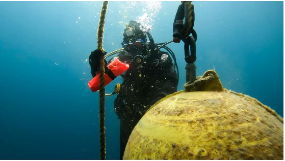
Below the surface, the sanctuary's true landscape is a submerged terrain of clay, sand, shoals, and deeper basins. Much of the bottom is the legacy of Pleistocene glaciation, smoothed and redistributed over millennia, and it now serves as the final resting place for an extraordinary collection of nineteenth and twentieth century vessels. Visibility in the bay can reach impressive levels for a freshwater lake, and the combination of cold temperatures and stable lake conditions has contributed to the unusual preservation of many wrecks.

The expansion of the sanctuary's boundary in 2014 added a vast offshore dimension to this landscape. Beyond the shallower waters near shore, the protected zone now extends across deep Lake Huron terrain reaching toward the international border with Canada. This larger offshore space includes varied bottom conditions, depth gradients, and harder-to-reach wreck sites, transforming the sanctuary from a near-shore preserve into a major Great Lakes underwater landscape with both accessible and remote components.
Thunder Bay National Marine Sanctuary ecosystems, habitats, and plant life

Although Thunder Bay National Marine Sanctuary is best known for its shipwrecks, it is also a substantial freshwater ecosystem, encompassing roughly 4,300 square miles of Lake Huron. The deeper, colder waters of this zone support populations of native Great Lakes fish and invertebrate communities, and the relatively undisturbed nature of the protected bottom helps sustain habitat that is increasingly rare in heavily industrialized freshwater systems.

Cold-water conditions and limited light penetration shape the ecology of the sanctuary. Areas with shallower wrecks and natural rocky structure develop communities of aquatic invertebrates and fish that use the structures for shelter, while deeper offshore areas maintain more open-water ecological character. The sanctuary's protected status reduces the risks of direct physical disturbance to both cultural and natural resources on the lake bed, an important consideration as the Great Lakes face ongoing pressure from invasive species, shoreline development, and changing water quality.

By preserving large stretches of lake bed away from intensive disturbance, the sanctuary contributes to the broader resilience of Lake Huron's freshwater systems. Its dual mandate, cultural and ecological, means that preservation decisions must balance the needs of submerged archaeological sites with the integrity of the living aquatic environment that surrounds them.

Thunder Bay National Marine Sanctuary wildlife and species highlights

The wildlife of Thunder Bay National Marine Sanctuary reflects the broader character of Lake Huron's aquatic fauna. Native Great Lakes fish species, including cold- and cool-water varieties, inhabit the sanctuary's waters, using both natural bottom structures and the submerged hulls of historic wrecks as shelter. These artificial reefs created by shipwrecks often concentrate fish populations in ways that are noticeable to divers and to those studying the lake underwater.

The aquatic invertebrate communities of the sanctuary are also a significant part of its ecological profile. They form the base of the food web that supports fish populations and contribute to the gradual biological colonization of submerged structures over time. Because the sanctuary's wrecks are carefully protected, these evolving natural communities can develop with comparatively limited disturbance from salvage activity or bottom-trawling.

On the surface and along the shoreline, the surrounding region hosts typical northeastern Great Lakes birdlife and seasonal migrations, while aquatic mammals associated with the broader Lake Huron basin also use the system. The sanctuary's protected waters may indirectly support broader regional biodiversity by maintaining quieter, less disturbed habitat within an otherwise heavily used waterway.

Thunder Bay National Marine Sanctuary conservation status and protection priorities

Thunder Bay National Marine Sanctuary represents a significant conservation achievement because it extends the concept of national marine protection into the freshwater realm. By safeguarding an estimated 116 historic shipwrecks within a single managed zone, the sanctuary demonstrates that cultural resource protection and ecological protection can be pursued together in a freshwater context, an approach rare in the North American inland seas.

From a cultural conservation standpoint, the sanctuary's framework establishes formal protocols for managing shipwreck sites, including limits on disturbance, regulated access for divers, archaeological research standards, and interpretive practices. This framework helps ensure that the wrecks remain a research and educational resource rather than being diminished by salvage, souvenir collection, or uncontrolled diving.

Ecologically, the sanctuary adds a buffer of regulated activity across a large portion of Lake Huron, reducing certain forms of bottom disturbance over time. The collaboration between the National Oceanic and Atmospheric Administration and the Michigan Department of Natural Resources signals a deliberate dual mandate: protecting underwater cultural heritage while contributing to the conservation of the broader Great Lakes ecosystem that surrounds it.

Thunder Bay National Marine Sanctuary cultural meaning and human context

The cultural context of Thunder Bay National Marine Sanctuary is inseparable from the broader history of the Great Lakes as a working inland sea. Northeastern Michigan developed economically through timber shipping, mineral transport, and passenger steamer travel, and the loss of vessels in these waters over more than a century left a physical record of that era on the lake bed. The sanctuary exists in part because of a regional recognition that this submerged record is an irreplaceable chapter of American industrial and transportation history.

At the community level, Alpena has long served as the cultural and logistical hub of the sanctuary. The presence of the Great Lakes Maritime Heritage Center, located on the Thunder Bay River near its mouth, ties the city's identity directly to the underwater resources offshore. The partnership between federal and state agencies, and the engagement of local institutions, museums, and divers, has made the sanctuary an important element of the region's cultural identity, not just an abstract environmental designation.

Top sights and standout views in Thunder Bay National Marine Sanctuary

The defining highlights of Thunder Bay National Marine Sanctuary center on its unmatched underwater heritage. With roughly 116 historically significant shipwrecks, including nineteenth-century wooden paddle steamers and twentieth-century steel-hulled freighters, the sanctuary offers a layered timeline of Great Lakes maritime history visible within a single body of water. Notable vessels such as SS Pewabic anchor the historical significance of the site.

Equally important is the sanctuary's status as the first National Marine Sanctuary on the Great Lakes, a designation that reshaped national expectations about inland-water protection. The 2014 boundary expansion multiplied its scale and added a deep offshore dimension, while the Great Lakes Maritime Heritage Center in Alpena provides an unusually rich interpretive anchor, with exhibits, an archaeological conservation laboratory, and education spaces that bring the underwater world into a tangible above-ground experience.

Best time to visit Thunder Bay National Marine Sanctuary

The character of a visit to Thunder Bay National Marine Sanctuary shifts with the seasons in ways familiar to anyone who knows the upper Great Lakes. Summer is the most active period for above-water exploration, with warmer temperatures, longer daylight hours, and calmer lake conditions making shoreline visits, boat trips, and visits to the Great Lakes Maritime Heritage Center in Alpena especially rewarding. Visibility on the lake tends to be at its most favorable during this part of the year, which is also when diving activity and educational programs are most concentrated.

Autumn brings a quieter atmosphere and cooler temperatures, accompanied by changing color along the shoreline that frames the view of Thunder Bay. Winter conditions can be harsh, with snow, ice, and strong storms reflecting the same forces that historically made these waters dangerous for shipping, though the region takes on a stark, peaceful beauty. Spring reawakens the landscape, with gradually warming water and renewed wildlife activity, while the calm of the early season offers a contemplative way to experience the coastal towns and interpretive sites before the busy summer months return.

Monthly climate preview

Long term temperature and precipitation records across twelve measured monthly intervals

Thunder Bay National Marine Sanctuary Climate Normals and Annual Weather Patterns

Representative coordinates at Thunder Bay National Marine Sanctuary record recorded mean temperatures spanning from negative four degrees Celsius in winter to nearly twenty degrees Celsius in summer alongside steady precipitation distribution. Exploring the complete twelve month climate profile reveals full monthly averages and historical baseline trends.
Annual mean7 °C
-4 °C20 °C
Jan-4°
Feb-4°
Mar-1°
Apr
May
Jun13°
Jul18°
Aug20°
Sep16°
Oct10°
Nov
Dec
Warmest month
August

19.5 °C

Coolest month
February

-4.1 °C

Wettest month
August

2.5 mm/day

Driest month
February

1.3 mm/day

Park location guide

Geography guide, regional context, and park location map for Thunder Bay National Marine Sanctuary

Thunder Bay National Marine Sanctuary park geography, regions, and map view in United States of America

Understand where Thunder Bay National Marine Sanctuary sits in United States of America through a broader geographic reading of the surrounding landscape, nearby location context, and its mapped position within the national park landscape.

How Thunder Bay National Marine Sanctuary fits into United States of America

The United States of America is a federal presidential republic and one of the world's largest countries by area and population. It consists of 50 states across a vast territory spanning multiple time zones, with its capital in Washington, D.C. and largest city in New York City. The nation has a diverse economy, influential political system, and significant cultural and military presence globally.

Wider geography shaping Thunder Bay National Marine Sanctuary in United States of America

The United States occupies a vast territory in North America, bordered by Canada to the north and Mexico to the south. The 48 contiguous states stretch from the Atlantic to the Pacific Ocean, while Alaska occupies the northwestern region and Hawaii is an archipelago in the Pacific. The country encompasses diverse terrain including the Rocky Mountains, Appalachian Mountains, Great Plains, and extensive river systems.

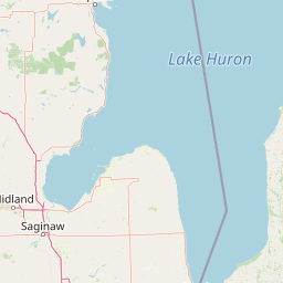
Map view of Thunder Bay National Marine Sanctuary

Use this park location map to pinpoint Thunder Bay National Marine Sanctuary in United States of America, understand its exact geographic position, and read its mapped placement within the surrounding landscape more clearly.

Pigeon | © OpenStreetMap contributors

Location context for Thunder Bay National Marine Sanctuary

Michigan
Natural feature types

View the Natural Landscapes of Thunder Bay National Marine Sanctuary

Continue your geographic exploration of Thunder Bay National Marine Sanctuary by examining the specific natural features and terrain that define this protected zone. MoriAtlas provides a structured look at the submerged and shoreline geography of this significant Great Lakes sanctuary.
Park atlas

Explore surrounding regional geography and connected Great Lakes protected areas

Parks Near Thunder Bay National Marine Sanctuary And Related Protected Landscapes

Browse nearby national parks and protected areas sharing the freshwater geography of the surrounding region. Comparing adjacent conservation landscapes provides deeper context into regional aquatic ecosystems and maritime heritage.
Marine protected areaMichigan
Mapped location lies within the park boundary#1 closest

Thunder Bay National Marine Sanctuary and Underwater Preserve: Geography and Protected Area Atlas

Maritime heritage sites and glacial freshwater geography in Lake Huron, Michigan.

Situated along the rugged northeastern coast of Lake Huron, Thunder Bay National Marine Sanctuary and Underwater Preserve protects over two hundred shipwreck sites spanning nearly two centuries of maritime history. This marine protected area offers a unique intersection of submerged archaeological resources, shallow shoals, coastal marshes, and limestone bedrock, forming a vital freshwater ecosystem in the Great Lakes region of Michigan.

Area
11,000 km²
Established
2000
Relief
Lowland
Climate
Temperate
Protected landscapeUpper Peninsula of Michigan
13 km away#2 closest

Northwest

Hiawatha National Forest: Geographic Overview and Protected Area Map of the Upper Peninsula

Coastal forest landscape and wilderness river corridors.

Hiawatha National Forest spans significant portions of the Upper Peninsula of Michigan, bridging the gap between northern hardwood forests and the boreal environments of the Great Lakes. This protected landscape encompasses extensive shorelines along Lake Superior, Lake Michigan, and Lake Huron, alongside six wilderness areas and five designated wild and scenic rivers.

Area
3,621.27 km²
Established
1931
IUCN
VI
Relief
Lowland
Wildlife reserveUnited States of America
About 21 km away#3 closest

Northwest

Round Island Wilderness: Geographic Overview of the Straits of Mackinac Wildlife Reserve

Coastal marsh, conifer forest, and hardwood interior terrain

Round Island Wilderness encompasses nearly all of a 378-acre island sanctuary, distinguished by its mature beech-maple hardwood interior and boreal-leaning conifer forests. This protected land remains an essential study of Great Lakes island ecology, standing as a quiet, undisturbed wilderness edge along the transit routes of the Michigan straits.

Area
1.53 km²
Relief
Lowland
Climate
Temperate
Access
Remote access
Wildlife reserveMichigan
31 km away#4 closest

Northwest

Horseshoe Bay Wilderness: A Detailed Geographic Overview of Michigan Protected Lands

Protected wetland habitat and Lake Huron coastal geography

Horseshoe Bay Wilderness represents a pristine 3,787-acre protected area located along the northwestern corner of Lake Huron in Michigan. Administered as part of the Hiawatha National Forest, this wilderness features an intricate post-glacial landscape of riparian wetlands, dense northern whitecedar stands, and quiet shallow waters that serve as vital spawning ground for local aquatic life.

Area
15.33 km²
Established
1987
IUCN
Ib
Relief
Lowland
Wildlife reserveMichigan
43 km away#5 closest

Northwest

Mackinac Wilderness Protected Area: Glacial Terrain and River Geography in Upper Michigan

A roadless wilderness reserve within Hiawatha National Forest

Uncover the geographic significance of Mackinac Wilderness, an IUCN Category Ib protected area in Michigan. The unit provides a distinct look at northern forest recovery through a terrain of sandy ridges, aspen and birch cover, and aquatic corridors. This study examines the interplay between postglacial landforms and the ongoing natural succession occurring along the Carp River drainage basin.

Area
49.5 km²
IUCN
Ib
Relief
Lowland
Climate
Temperate
Protected landscapeMichigan
About 54 km away#6 closest

Southwest

Huron, Manistee National Forests: Geography, Protected Land, and Michigan Landscape Atlas

Exploration of glacial terrain, river basins, and coastal wilderness.

The Huron, Manistee National Forests stand as a significant protected landscape in northern Michigan, featuring a vast network of inland rivers and lakes. This atlas entry provides geographic context on its glacial geology, the rare dune ecosystems along Lake Michigan, and the distribution of pine-dominated forest habitats across the two administrative units.

Area
3,960 km²
IUCN
VI
Relief
Lowland
Climate
Temperate
National parkOntario
66 km away#7 closest

East

Bruce Peninsula National Park: National Park Protected Landscape and Geographic Context in Ontario

Discover its mapped boundaries and regional landscape identity.

Bruce Peninsula National Park stands as a protected national park entity within Ontario, offering a distinct geographic profile. Its mapped boundaries and position within the regional atlas are crucial for understanding its landscape character. MoriAtlas facilitates exploration of the park's protected status and its contribution to the conservation landscape of Ontario.

Area
154 km²
Established
1987
IUCN
II
Visitors
460.4K annual
National parkMichigan
139 km away#8 closest

West

Sleeping Bear Dunes National Lakeshore: Atlas, Maps, and Protected Landscape Geography

Great Lakes freshwater coast and glacial dune systems

Sleeping Bear Dunes National Lakeshore showcases the unique intersection of glacial geology and freshwater ecology. This protected area features massive dunes resting on ancient glacial deposits, backed by beech and maple forests. The geographic scope includes the vast shoreline of Lake Michigan, inland waters such as Glen Lake, and the distinct maritime history found across the remote North and South Manitou Islands.

Area
288.13 km²
Established
1970
IUCN
III
Visitors
1.5M annual

Common questions about visiting, size, designation, and location context for Thunder Bay National Marine Sanctuary

Thunder Bay National Marine Sanctuary FAQs for park facts, access, geography, and protected area context

Find quick answers about Thunder Bay National Marine Sanctuary, including protected-area facts, park geography, trail and visitor context, and how the park fits into its surrounding country and regional landscape.
MoriAtlas Explorer

Continue Your Protected Areas Search Across the Global Atlas

Deepen your exploration by continuing the structured search for national parks and protected areas worldwide. Utilize the comprehensive filtering capabilities to compare different conservation landscapes and refine your understanding of global park geography. Discover more about the distribution and characteristics of protected natural areas.

Global natural geography



