

Mori Atlas logo
Natural monumentUhlířský vrch

Tracing volcanic geology and Baroque architecture across this protected natural summit and linden avenue.

Uhlířský vrch Natural Monument and Historic Pilgrimage Landscape in the Nízký Jeseník Highlands

Uhlířský vrch stands as a distinct extinct volcanic cone within the rolling Nízký Jeseník highlands of the Czech Republic. This protected natural monument encompasses geological exposures of basaltic lava and tuff, alongside an eighteenth-century pilgrimage complex. Visitors can examine the interplay between the preserved volcanic terrain and the historic linden-lined approach that culminates in panoramic views across the regional ridges.

extinct volcanovolcanic geologybasalt hillnatural monumentCzech SilesiaNízký Jeseník
An illustrative depiction of a white church with a spire sitting on top of a green, forest-covered hill, overlooking a small village in the valley.

Uhlířský vrch

Natural monument

Park overview

Structured park overview, official facts, and landscape profile for Uhlířský vrch

Uhlířský vrch park facts, protected area profile, and essential visitor context

Review the core facts for Uhlířský vrch, including designation, size, terrain, visitor scale, habitats, and operating context in one park-focused overview.

About Uhlířský vrch

Uhlířský vrch is a modest but geologically and culturally rich hill in the northwestern part of Czech Silesia, set within the broader Nízký Jeseník mountain system. It rises to about 672 meters, just southwest of the town of Bruntál, and functions simultaneously as a small volcanic landform, a protected geological site, and a long-standing pilgrimage destination. The hill embodies the unusual pairing of a young, basaltic volcanic cone with a carefully designed eighteenth-century religious landscape.

The hill's geological significance is tied to its volcanic origin. Although small in absolute size, Uhlířský vrch is counted among the country's youngest extinct volcanoes. Its bedrock is basalt, and a lava flow that once poured eastward and northeastward from the vent is still recognizable in the local geology. On the southern slope, a former quarry worked for tuff reveals the eruptive character of the hill: the predominantly sandy tuffs contain larger volcanic bombs that document the explosive phase of the eruption. That exposure and its surroundings were designated a natural monument in 1966.

The summit is dominated by the Baroque pilgrimage Church of the Virgin Mary of Help. It was built between 1755 and 1765 by the Krnov architect Jiří Friedrich Gans on the site of an earlier wooden chapel erected in 1653 by Oswald of Liechtenstein as a visible symbol of Catholic recovery in the region after the Thirty Years' War. The approach to the church is shaped by a roughly one-kilometer-long, four-row linden avenue, planted between 1766 and 1770, which has itself become a protected and award-winning cultural element of the landscape.

Along the upper part of the avenue stands a restored Way of the Cross, originally erected in 1916 with paintings inspired by the Munich artist Gebhardt Fugel. After the stations fell into ruin in the postwar period, local carver František Nedomlel produced fifteen new wooden sculptures between 2001 and 2005, each made from a different wood species native to the Nízký Jeseník. Today Uhlířský vrch serves both as a small-window geological teaching site and as a panoramic viewpoint, with views reaching neighboring Nízký Jeseník ridges and, on clear days, the higher peaks of the Hrubý Jeseník.

Quick facts and research context for Uhlířský vrch

Uhlířský vrch lies roughly two kilometers southwest of Bruntál in the Moravian-Silesian Region of the Czech Republic, within the cadastral territory of Bruntál-město. Geologically it belongs to the Nízký Jeseník highlands and is composed of basalt, with exposed sandy tuffs containing larger volcanic bombs on its southern slope.

The hill itself reaches about 672 meters in elevation, while the protected natural monument on its slopes covers approximately 3.54 hectares at 620 to 665 meters above sea level. It was declared a přírodní památka (natural monument) on 26 April 1966 by the District National Committee in Bruntál.

The summit combines natural and cultural heritage: a Baroque pilgrimage church, a historic four-row linden avenue from the 1760s, and a restored Way of the Cross. The site lies within the Odra river basin and is also recognized as a cultural monument because of its avenues and religious structures.

Protection and recognition

Terrestrial protected area records and establishment chronology for Uhlířský vrch

Uhlířský Vrch Protection Status and Designated Conservation History

Uhlířský vrch maintains documented terrestrial protection status established in 1966 across designated natural boundaries. Conservation data details the formal management scope and historical recognition framework associated with the protected landscape.

Protection details

Protection scope
Terrestrial
Designated year
1966
Transboundary protection
No
Park context

Deeper park guide and search-rich context for Uhlířský vrch

Uhlířský vrch history, landscape, wildlife, and travel context

Explore Uhlířský vrch through its history, landscape character, ecosystems, wildlife, conservation priorities, cultural context, and seasonal travel timing in a structured park guide built for atlas discovery and search intent.

Why Uhlířský vrch stands out

Uhlířský vrch is best known for being one of the youngest extinct volcanoes in the Czech Republic, whose basaltic bedrock and tuff deposits remain exposed in a small former quarry on the southern slope. That quarry, together with the surrounding volcanic substrate, has been protected since 1966 as a geological natural monument. Equally central to the hill's identity is its Baroque pilgrimage landscape: the Church of the Virgin Mary of Help crowning the summit, approached along a four-row linden avenue planted in the 1760s. The combination of a young, well-preserved volcanic cone with an eighteenth-century religious ensemble and a restored Way of the Cross gives Uhlířský vrch a distinctive character within the Nízký Jeseník highlands.
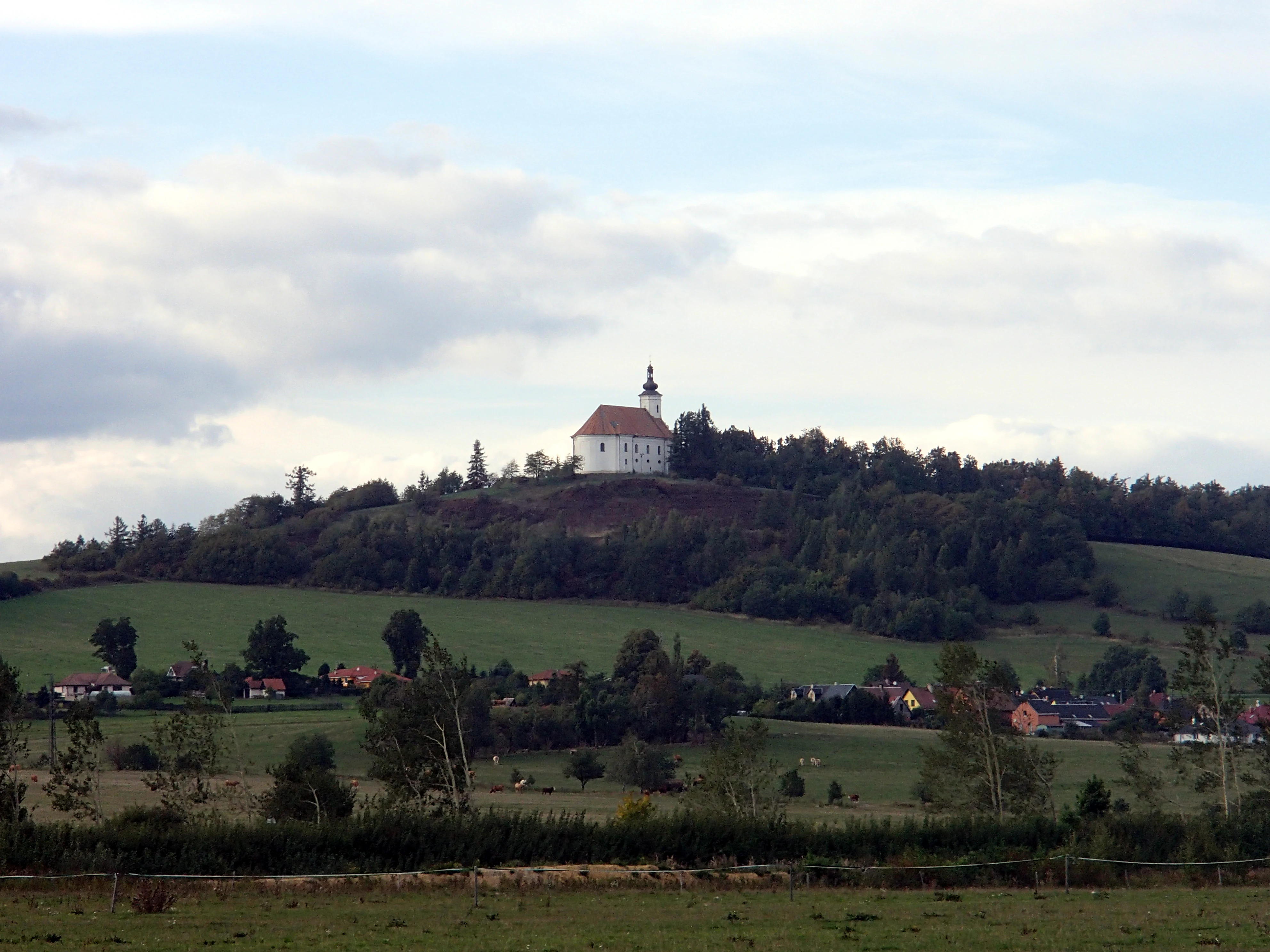
A wide landscape view of a green hill topped with a white pilgrimage church, surrounded by trees and a rural village at the base.
The pilgrimage church of the Virgin Mary situated atop Uhlířský vrch, an extinct volcano.

Uhlířský vrch history and protected-area timeline

The hill's modern history is layered across two intertwined threads: its geological past and its cultivation as a pilgrimage site.

The volcanic foundation of Uhlířský vrch dates back to relatively recent geological activity, which is why the cone is considered one of the youngest extinct volcanoes on Czech territory. This volcanic origin was once actively quarried, especially for tuff on the southern slope, and it was the scientific value of that quarry exposures, with sandy tuffs and embedded volcanic bombs, that led the District National Committee in Bruntál to declare the site a natural monument on 26 April 1966.

The cultural history began in the mid-seventeenth century, when Oswald of Liechtenstein, a regional commander of a religious order, had a wooden pilgrimage chapel erected on the summit in 1653 as a far-visible symbol of Catholic triumph over Protestantism in the Silesian lands. By the mid-eighteenth century that modest chapel had been replaced by the present single-nave Baroque church of the Virgin Mary of Help, built between 1755 and 1765 to a design by the Krnov-based architect Jiří Friedrich Gans.

The site's careful landscape design took shape in the second half of the eighteenth century. Around 1766 to 1770, the freeman and commander von Riedheim ordered the planting of the four-row linden avenue leading from the town up to the church. That avenue gives the hill its present formal approach. In 1916, fourteen stations of a Way of the Cross were added along its upper section, with paintings based on designs by the Munich painter Gebhardt Fugel; these were largely destroyed after the Second World War. A modern carver, František Nedomlel from Bruntál, produced fifteen replacement wooden sculptures between 2001 and 2005, each in a different local wood. The avenue itself was declared a memorable tree feature in 1973, and the whole ensemble became a cultural monument in the 1990s; in 2022 it was voted Alley of the Year in a national competition.

Uhlířský vrch landscape and geographic character

Though modest in size, Uhlířský vrch presents a clearly individual profile within the rolling Nízký Jeseník highlands of Czech Silesia. The hill rises to about 672 meters and is built on basalt, the bedrock of an extinct volcanic vent that once sent a lava flow eastward and northeastward across the surrounding terrain.

The southern slope bears the most visible trace of that volcanic past: an abandoned tuff quarry whose sandy tuffs and embedded volcanic bombs reveal the explosive character of the original eruption. The quarry walls and adjacent exposures are the physical core of the natural monument that protects roughly 3.54 hectares between 620 and 665 meters above sea level.

To the north and east, the summit opens into a more cultivated, humanized landscape. A roughly one-kilometer-long, four-row linden avenue planted in the 1760s climbs toward the hilltop, framing a defined axis between the town of Bruntál and the pilgrimage church on the summit. Because of its elevation relative to the surrounding countryside, the summit serves as a long-distance viewpoint, with open vistas over neighboring Nízký Jeseník ridges and, on clear days, the more dramatic skyline of the Hrubý Jeseník in the distance.
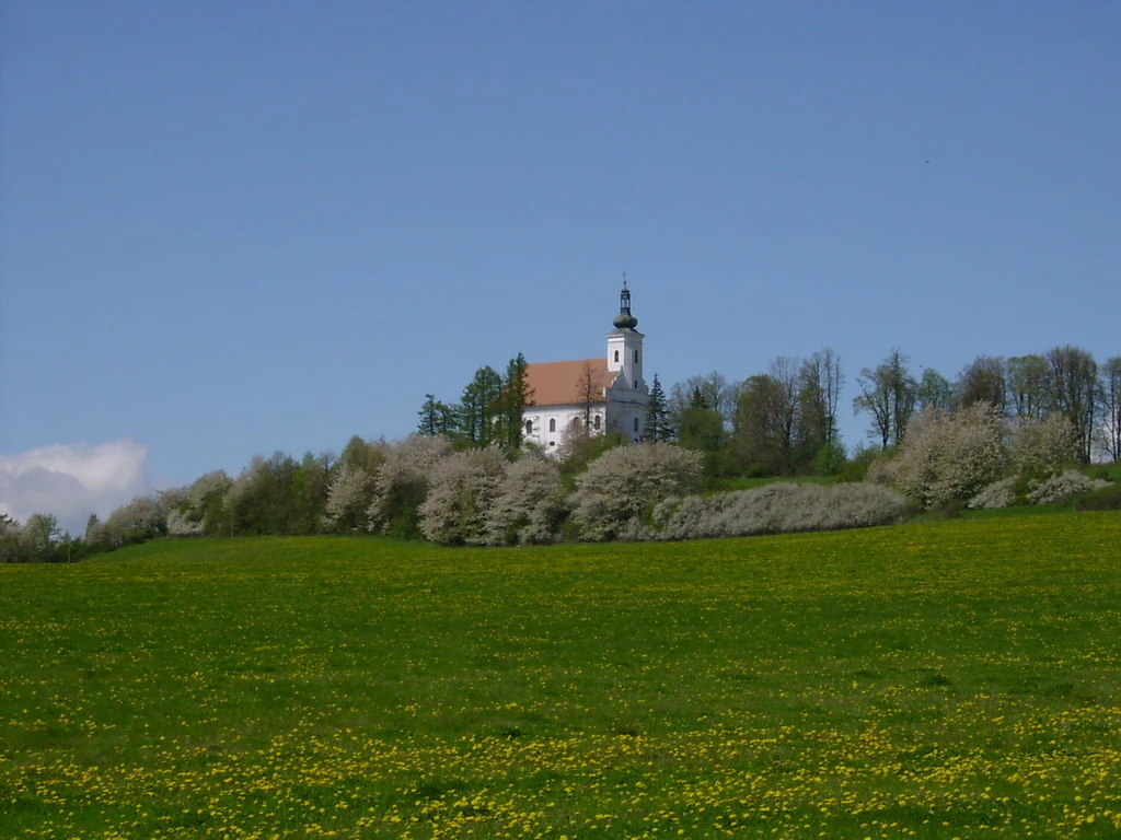
A white pilgrimage church with a tall steeple stands on a grassy hill, framed by blooming trees and a green meadow under a clear blue sky.
The baroque pilgrimage church sits atop the Uhlířský vrch volcanic hill, surrounded by trees.

Uhlířský vrch ecosystems, habitats, and plant life

Uhlířský vrch is primarily valued as a geological rather than biological natural monument. Its core significance lies in the exposure of volcanic rocks: a basaltic main body overlain by predominantly sandy tuffs containing larger volcanic bombs, set within the broader sedimentary and volcanic geology of the Nízký Jeseník.

The protected area is small, covering about 3.54 hectares near the summit, and it is the rock exposures themselves, rather than vegetative communities, that constitute the main ecological interest. The hill belongs to the Odra river basin, and its slopes combine exposed rock with woodland typical of the Nízký Jeseník. The protected status, which has been in place since 1966 and falls within the broader Czech system of přírodní památka, recognizes this compact but scientifically instructive volcanic profile in a region otherwise better known for its sedimentary uplands.

Uhlířský vrch conservation status and protection priorities

The volcanic outcrops and former tuff quarry on the southern slope of Uhlířský vrch have been formally protected as a přírodní památka, a natural monument, since 26 April 1966. The designation was issued by the Okresní národní výbor Bruntál and aims to preserve the small but scientifically valuable exposures of basalt and sandy tuff with embedded volcanic bombs that document the hill's young eruptive history.

The protected area covers about 3.54 hectares between roughly 620 and 665 meters above sea level and is registered under code 472 in the national protected-area database. The site illustrates how even very small protected parcels can carry significant geological and didactic value, providing a near-surface window into the youngest phase of volcanism within the broader Nízký Jeseník landscape.

Uhlířský vrch cultural meaning and human context

Uhlířský vrch is anchored in a strongly Catholic, Silesian pilgrimage tradition that grew from the aftermath of the Thirty Years' War. The original 1653 wooden chapel was commissioned by Oswald of Liechtenstein as a deliberate, far-visible symbol of Catholic restoration in a region that had been heavily contested between confessions.

In the mid-eighteenth century this modest wooden structure was replaced by the Baroque Church of the Virgin Mary of Help, designed by the Krnov architect Jiří Friedrich Gans. Around the same period, the freeman and commander von Riedheim ordered the planting of the four-row linden avenue that physically and symbolically connects the town of Bruntál with the summit. The avenue, declared památné stromy in 1973, and the broader ensemble became a Czech cultural monument in the 1990s and won the national Alley of the Year title in 2022. This combination of religious architecture, historic avenues, and a restored Way of the Cross, with sculptures carved by the Bruntál artist František Nedomlel between 2001 and 2005, gives the hill a distinctive identity within the regional cultural landscape of Czech Silesia.

Top sights and standout views in Uhlířský vrch

Uhlířský vrch combines the geology of one of the Czech Republic's youngest extinct volcanoes with a Baroque pilgrimage ensemble on the summit: the Church of the Virgin Mary of Help, an eighteenth-century four-row linden avenue, and a recently restored Way of the Cross with fifteen locally carved wooden sculptures.

Its small protected quarry on the southern slope preserves sandy tuffs and embedded volcanic bombs, and the whole hill also functions as a panoramic viewpoint over the Nízký Jeseník and, in clearer weather, toward the Hrubý Jeseník mountains.

Best time to visit Uhlířský vrch

The summit's character shifts with the seasons in ways that matter for both scenery and atmosphere. Late spring into early summer is when the linden avenue most strongly defines the approach to the church, with the trees in fresh leaf and the avenue forming a green corridor from the outskirts of Bruntál up to the hilltop. Summer offers full canopy, long daylight over the surrounding ridges, and comfortable conditions for walking the roughly one-kilometer avenue.

Autumn brings the avenue's other defining moment, when the linden leaves turn color and the view from the summit over the Nízký Jeseník, and toward the distant Hrubý Jeseník, tends to be at its clearest. Winter is quieter and colder, occasionally with snow on the trees and the Baroque silhouette of the church standing out starkly above the white landscape, but visitors should expect shorter days and at times more demanding conditions along the open ridge.


Monthly climate preview

Long-term representative monthly averages and temperature ranges for Moravskoslezský kraj

Uhlířský vrch Climate Normals, Annual Temperature and Precipitation Rhythm

Representative coordinate measurements record monthly mean temperatures spanning from negative values to over eighteen degrees, alongside corresponding precipitation rates across the year. Examining the full twelve-month profile reveals detailed baseline temperature variations and precipitation distributions.
Annual mean7 °C
-4 °C19 °C
Jan-4°
Feb-2°
Mar
Apr
May13°
Jun16°
Jul19°
Aug18°
Sep13°
Oct
Nov
Dec-3°
Warmest month
July

18.6 °C

Coolest month
January

-3.9 °C

Wettest month
July

3 mm/day

Driest month
January

1.3 mm/day

Park location guide

Geography guide, regional context, and park location map for Uhlířský vrch

Uhlířský vrch park geography, regions, and map view in Czechia

Understand where Uhlířský vrch sits in Czechia through a broader geographic reading of the surrounding landscape, nearby location context, and its mapped position within the national park landscape.

How Uhlířský vrch fits into Czechia

Czech Republic is a landlocked Central European country with a population of approximately 10.9 million people. The nation was established as an independent state on January 1, 1993, following the dissolution of Czechoslovakia. Its capital and largest city is Prague, with other major urban centers including Brno, Ostrava, Plzeň, and Liberec.

Wider geography shaping Uhlířský vrch in Czechia

The Czech Republic is a landlocked country in Central Europe. It is bordered by Germany to the west, Austria to the south, Poland to the northeast, and Slovakia to the southeast. The landscape is predominantly hilly, with the territory covering 78,871 square kilometers.

Map view of Uhlířský vrch

Use this park location map to pinpoint Uhlířský vrch in Czechia, understand its exact geographic position, and read its mapped placement within the surrounding landscape more clearly.

Pigeon | © OpenStreetMap contributors

Location context for Uhlířský vrch

Moravskoslezský kraj

Visualizing the terrain, basalt geology, and pilgrimage architecture of a protected highland cone

Uhlířský Vrch Photos and Volcanic Landscape Imagery

Photographic records capture the distinct volcanic topography, exposed tuff quarries, and historic linden avenues defining the protected hill environment. Visual documentation reveals the geological character and cultural landmarks spanning the upland terrain.

A wide landscape view of a green hill topped with a white pilgrimage church, surrounded by trees and a rural village at the base.

Close up view of volcanic rock formations and reddish-brown soil on a sloped hillside.

A white pilgrimage church with a tall steeple stands on a grassy hill, framed by blooming trees and a green meadow under a clear blue sky.

Park atlas

Compare regional volcanic terrain and neighboring protected landscapes

Explore Protected Areas and Parks Near Uhlířský Vrch in Czech Silesia

Continue browsing other parks near Uhlířský vrch to examine adjacent geological monuments and surrounding highland terrain. Broadening the protected-area search helps place local volcanic formations within a wider regional context.
Natural monumentOlomouc Region
About 27 km away#1 closest

West

Sobotín, domov důchodců Protected Natural Monument in the Czech Republic

A specialized Olomouc Region conservation site and habitat refuge

Examine the geographic and ecological boundaries of Sobotín, domov důchodců, a protected natural monument situated in the Olomouc Region. Learn how this site provides essential environmental stability within its broader regional setting, serving as a critical example of small scale habitat conservation in northern Moravia.

Area
0.001 km²
Established
2013
IUCN
III
Relief
Lowland
Natural monumentMoravskoslezský kraj
About 36 km away#2 closest

Southeast

Vrásový soubor v Klokočůvku: Geological Structure and Protected Monument Atlas

Regional rock exposures in the Moravian-Silesian landscape.

Vrásový soubor v Klokočůvku features an exceptional exposure of folded Culm sedimentary strata known as Dračí skála. This protected monument offers a clear view of complex fold geometries and tectonic deformation, serving as a primary site for understanding the geological history of the eastern Bohemian Massif landscape.

Area
0.013 km²
Established
1998
IUCN
III
Relief
Lowland
Protected landscapeDolnośląskie
About 41 km away#3 closest

Northwest

Śnieżnicki Park Krajobrazowy: Protected Landscape and Mountain Geography Atlas

Eastern Sudetes protected area in Dolnoslaskie, Poland

Located in the Dolnoslaskie region, Śnieżnicki Park Krajobrazowy protects a striking mosaic of primeval forest and varied mountain relief. This entry maps its core components, from the high peak of Śnieżnik to the intricate karst landforms and deep river valleys that define its regional geographic character.

Area
288 km²
Established
1981
Relief
Mountain
Climate
Alpine
Natural monumentOlomouc Region
About 44 km away#4 closest

Northwest

Vodopády Stříbrného potoka: Natural Monument and Mountain Stream Geography in Olomouc Region

Geomorphological landmark within the Rychlebské hory mountain range

Vodopády Stříbrného potoka is a protected natural monument in the Czech Republic, encompassing a narrow, steep-sided valley defined by bedrock cascades. This compact site highlights mountain stream geomorphology and serves as a significant feature in the Rychlebské hory, offering insight into the distinctive eroded terrain of the Jeseník District.

Area
0.017 km²
Established
1965
IUCN
III
Relief
Mountain
Protected areaOpole Voivodeship
About 48 km away#5 closest

North

Przyłęk nad Białą Głuchołaską: Protected Area and River Landscape Geography in Poland

Mapped riparian habitats within Opole Voivodeship

Focusing on the Biała Głuchołaska river valley, this area preserves a complex system of active river channels, gravel bars, and terrace forests. The landscape transitions from wet willow-poplar galleries to stable oak-hornbeam communities. As a Natura 2000 site in the Opole Voivodeship, the terrain provides a clear look at submontane river processes interacting with lowland forest habitats.

Area
3.193 km²
Relief
Lowland
Climate
Temperate
Scope
Terrestrial
Natural monumentOlomouc Region
About 49 km away#6 closest

South

Veselíčko Natural Monument: Geographic Profile of a Czech Protected Area

Concentrated conservation and habitat mapping in the Olomouc Region

Located in the Olomouc District, Veselíčko is a compact natural monument dedicated to specialized habitat protection. This site acts as a key component of the regional conservation network, offering insight into the intersection of cultural heritage and wildlife refuge management in the Czech Republic.

Area
0.001 km²
Established
2013
IUCN
III
Relief
Lowland
A horizontal watercolor illustration of a river landscape with lush green banks and rolling purple hills in the background against a white background.
Natural monumentMoravskoslezský kraj
About 52 km away#7 closest

Southeast

Meandry Staré Odry: Geography of a Protected Natural Monument in Moravian-Silesian Region

Historic river meanders and floodplain riparian ecosystems

Meandry Staré Odry represents a vital conservation fragment within the Czech Republic, preserving the original meandering path of the Odra River. This natural monument is defined by quiet oxbow pools, seasonally flooded meadows, and dense riparian forests. Its geographic profile highlights the contrast between historical water dynamics and the surrounding landscape of the Moravskoslezský kraj, providing a precise look at riparian terrain.

Area
0.278 km²
Established
1999
IUCN
IV
Relief
Lowland
A soft, artistic watercolor painting showing a stylized, rolling green landscape with forests, meadows, and a winding path.
Nature reserveOlomouc Region
About 54 km away#8 closest

Northwest

Račí údolí Nature Reserve: A Protected Forest Valley in the Olomouc Region

Geographic boundaries and metamorphic woodland terrain

Račí údolí serves as a vital protected area in the Jeseník foothills, showcasing remnants of oak and beech forests amidst rocky gneiss terrain. This valley map highlights the intersection of natural stream-cut geography and centuries of human cultural presence, providing a dense, immersive look at regional forest conservation and metamorphic geology.

Area
0.62 km²
Established
1998
IUCN
IV
Relief
Upland

Common questions about visiting, size, designation, and location context for Uhlířský vrch

Uhlířský vrch FAQs for park facts, access, geography, and protected area context

Find quick answers about Uhlířský vrch, including protected-area facts, park geography, trail and visitor context, and how the park fits into its surrounding country and regional landscape.
MoriAtlas Explorer

Continue Your Protected Areas Search Across the Global Atlas

Deepen your exploration by continuing the structured search for national parks and protected areas worldwide. Utilize the comprehensive filtering capabilities to compare different conservation landscapes and refine your understanding of global park geography. Discover more about the distribution and characteristics of protected natural areas.

Global natural geography