Mori Atlas logo
National parkUramba Bahía Málaga National Natural Park

Discover the mapped natural terrain and protected boundaries of this national park in Valle del Cauca Department.

Uramba Bahía Málaga National Natural Park: Protected Landscape Geography and Atlas Context

(Parque Natural Nacional Uramba Bahía Málaga)

Uramba Bahía Málaga National Natural Park stands as a significant protected landscape within the Valle del Cauca Department of Colombia. This page offers an atlas-driven exploration of its geographic identity, focusing on the mapped extent of its protected area and the surrounding natural terrain. Understand the park's place within regional geography through detailed mapping and landscape context, providing essential data for geographic discovery.

National ParksColombia Pacific CoastWhale WatchingMarine Protected AreasCoastal EcosystemsHumpback Whales

Uramba Bahía Málaga National Natural Park

National park

Park overview

Structured park overview, official facts, and landscape profile for Uramba Bahía Málaga National Natural Park

Uramba Bahía Málaga National Natural Park park facts, protected area profile, and essential visitor context
Review the core facts for Uramba Bahía Málaga National Natural Park, including designation, size, terrain, visitor scale, habitats, and operating context in one park-focused overview.

About Uramba Bahía Málaga National Natural Park

Uramba Bahía Málaga National Natural Park represents one of Colombia's most significant recent additions to its protected areas network. Established in 2010, the park protects a remarkable coastal and marine landscape along the Pacific coast in the Valle del Cauca Department, centered around the sheltered waters of Málaga Bay. The proximity to Buenaventura, Colombia's principal Pacific port city, makes the park accessible yet maintains its natural character across most of its extent.

The park's ecological significance stems from its position within one of the world's most biodiverse marine regions. The combination of coastal forest, mangrove systems, estuaries, and open marine waters creates a complex habitat mosaic that supports numerous species. The humpback whale population that seasonally occupies these waters has drawn particular attention, with researchers and conservationists recognizing Málaga Bay as a critical habitat in the broader context of Eastern Pacific whale populations.

Most of the natural area remains in pristine condition, with human development limited to a few small communities such as Juanchaco, Ladrilleros, and La Barra, as well as a Colombian naval installation. This relative lack of intensive development has allowed the park's ecosystems to maintain their ecological integrity, contributing to its value as both a conservation area and an emerging ecotourism destination.

Quick facts and research context for Uramba Bahía Málaga National Natural Park

Uramba Bahía Málaga National Natural Park spans 471 square kilometers along Colombia's Pacific coast in Valle del Cauca Department, established in 2010 as the country's 56th national natural park. The protected area encompasses both coastal land and marine waters around Málaga Bay, with the nearest major population center being the port city of Buenaventura. The park is governed by Colombia's National System of Protected Areas (SINAP) and holds IUCN category II designation as a national park. Its most notable ecological feature is the seasonal presence of humpback whales that use the bay as a breeding and calving ground from June through October.

Park context

Deeper park guide and search-rich context for Uramba Bahía Málaga National Natural Park

Uramba Bahía Málaga National Natural Park history, landscape, wildlife, and travel context
Explore Uramba Bahía Málaga National Natural Park through its history, landscape character, ecosystems, wildlife, conservation priorities, cultural context, and seasonal travel timing in a structured park guide built for atlas discovery and search intent.

Why Uramba Bahía Málaga National Natural Park stands out

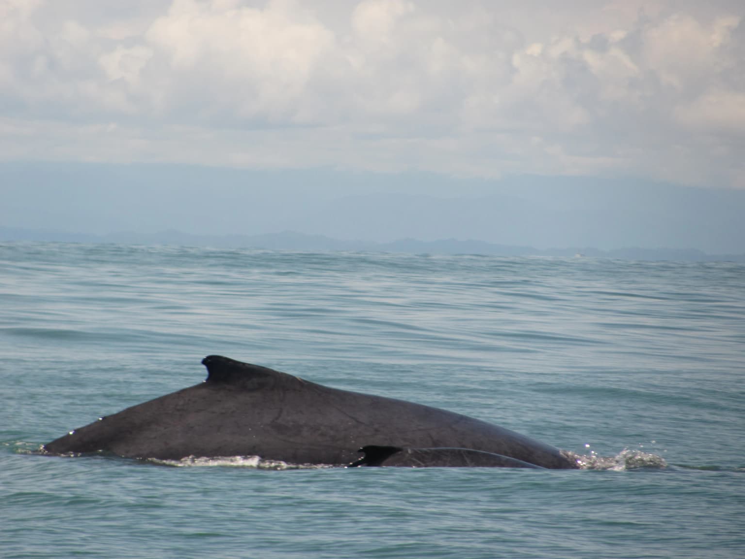
Uramba Bahía Málaga is best known for its extraordinary humpback whale population, which represents the largest concentration of breeding humpbacks along the Colombian Pacific coast. The protected waters of Málaga Bay provide a critical habitat where these magnificent marine mammals gather each year between June and October to give birth and raise their calves. This seasonal phenomenon has transformed the park into Colombia's premier whale watching destination, drawing visitors from around the world to witness these gentle giants in their natural environment. The park's significance extends beyond whales, however, as it also protects a rich mosaic of coastal and marine ecosystems that support high biodiversity.

Humpback whale with dorsal fin visible above water surface in ocean
Humpback whale surfacing in the ocean waters of Bahía Málaga

Uramba Bahía Málaga National Natural Park history and protected-area timeline

Uramba Bahía Málaga National Natural Park was formally established in 2010, becoming Colombia's 56th national natural park. The creation of this protected area reflected growing recognition of the ecological importance of Colombia's Pacific coastal waters and the need to conserve critical habitats for marine species, particularly the significant humpback whale population that utilizes Málaga Bay as a seasonal breeding ground.

The park's establishment was part of Colombia's broader efforts to expand its national park system and strengthen marine conservation. By incorporating both terrestrial and marine environments within a single protected designation, the park maintains ecological connectivity between coastal forests and ocean ecosystems. The governance falls under the National System of Protected Areas (SINAP), Colombia's unified framework for managing the nation's protected lands and waters.

Uramba Bahía Málaga National Natural Park landscape and geographic character

The landscape of Uramba Bahía Málaga encompasses a distinctive Pacific coastal environment characterized by the interplay between forested land and marine waters. The protected area includes coastal plains that support tropical forest vegetation, mangrove systems along sheltered coves, and the open waters of Málaga Bay itself. The bay provides a relatively protected marine environment that contrasts with the more exposed Pacific coastline elsewhere in the region.

The terrestrial portions of the park feature wet tropical forest, transitional forest types, and flooded forest areas that reflect the high rainfall characteristic of Colombia's Pacific coast. Beaches and estuarine areas add diversity to the coastal landscape, while the marine component extends into pelagic zones that support the park's marine wildlife. This combination of habitats creates a visually varied landscape that transitions from dense forest-covered slopes to open water.

Uramba Bahía Málaga National Natural Park ecosystems, habitats, and plant life

The ecological character of Uramba Bahía Málaga reflects the extraordinary biodiversity of Colombia's Pacific coast region. The park protects multiple interconnected ecosystems, including wet tropical forest that covers much of the coastal land, transitional forest zones, flooded forest areas in low-lying sections, and the distinctive mangrove systems that fringe the bay's edges. These terrestrial environments transition seamlessly into marine habitats through estuarine areas and coastal beaches.

The marine ecosystems within the protected area include both coastal waters and deeper pelagic zones, creating a comprehensive marine protected environment. The combination of productive coastal waters and the sheltered nature of Málaga Bay provides ideal conditions for marine life, supporting populations of fish, marine mammals, and other ocean species. The seasonal influx of humpback whales represents the most visible manifestation of the park's marine ecological value.

Uramba Bahía Málaga National Natural Park wildlife and species highlights

The wildlife of Uramba Bahía Málaga is highlighted most dramatically by the seasonal presence of humpback whales. These massive cetaceans migrate to the protected waters of Málaga Bay to breed and give birth, with peak activity occurring between June and October. The bay is recognized as supporting the largest concentration of breeding humpback whales along the entire Colombian Pacific coast, making it a critically important habitat for this species.

Beyond whales, the diverse habitats within the park support a variety of wildlife. The forest areas provide habitat for numerous species of birds, mammals, and other terrestrial animals, while the marine environments support fish populations and other ocean life. The mangrove systems and estuaries serve as important nursery areas for marine species and feeding grounds for birds. This combination of habitats creates conditions that support both resident species and those that utilize the area seasonally.

Uramba Bahía Málaga National Natural Park conservation status and protection priorities

Uramba Bahía Málaga National Natural Park was created to protect a globally significant coastal and marine environment along Colombia's Pacific coast. The park's conservation value centers on its role as a critical habitat for humpback whales, which gather in the protected waters of Málaga Bay in significant numbers each year to breed and raise their young. This seasonal concentration represents an important population segment within the broader context of Eastern Pacific humpback whales.

The protected area also conserves the diverse coastal ecosystems that characterize this portion of Colombia's Pacific region, including wet tropical forests, mangroves, and the productive marine waters of the bay. By encompassing both terrestrial and marine environments within a single protected area, the park maintains ecological connections between forest and ocean ecosystems. The IUCN category II designation reflects the park's primary objective of protecting natural ecosystems while allowing for compatible human uses such as ecotourism.

Uramba Bahía Málaga National Natural Park cultural meaning and human context

The Uramba Bahía Málaga area has been inhabited by local communities whose presence predates the establishment of the national park. Small settlements such as Juanchaco, Ladrilleros, and La Barra represent traditional coastal communities that maintain connections to the marine environment. A Colombian naval presence in the area adds another dimension to the human context of the park.

The park's establishment has created a framework for balancing conservation with sustainable use, recognizing both the ecological importance of the area and the cultural connections of local communities to the land and sea. Ecotourism related to whale watching has emerged as a significant activity, creating opportunities for economic benefit while reinforcing the value of maintaining the natural environment that attracts visitors.

Top sights and standout views in Uramba Bahía Málaga National Natural Park

The defining highlight of Uramba Bahía Málaga is the extraordinary seasonal presence of humpback whales that gather in the protected waters of Málaga Bay from June through October. This concentration represents the largest breeding population along Colombia's Pacific coast, providing visitors with world-class whale watching opportunities in a spectacular natural setting. The combination of these marine giants with the backdrop of lush tropical forest lining the bay creates an unforgettable visual experience.

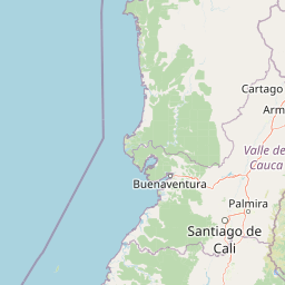
The park also offers the opportunity to explore diverse ecosystems within a single protected area, from mangrove-lined shores to wet tropical forests and open Pacific waters. The relative proximity to Buenaventura makes this Pacific coast gem accessible for visitors seeking to experience one of Colombia's most biologically rich coastal environments. The relative seclusion of most of the park, combined with the pristine nature of its landscapes, provides an authentic natural experience away from more heavily visited destinations.

Best time to visit Uramba Bahía Málaga National Natural Park

The optimal time to visit Uramba Bahía Málaga National Natural Park is during the humpback whale season, which runs from June through October. During these months, the whales are most actively using the bay for breeding and calving, providing the best opportunities for whale watching excursions. The peak activity typically occurs in August and September when the number of whales in the bay reaches its highest levels.

The Pacific coast climate means that rainfall is common throughout the year, with the wetter seasons bringing heavier precipitation to the forested portions of the park. Visitors planning trips during the whale season should be prepared for variable weather conditions while also having the best chance of witnessing the park's most famous inhabitants. The combination of wildlife viewing opportunities and the park's natural landscapes makes this seasonal window particularly appealing.

Park location guide

Geography guide, regional context, and park location map for Uramba Bahía Málaga National Natural Park

Uramba Bahía Málaga National Natural Park park geography, regions, and map view in Colombia
Understand where Uramba Bahía Málaga National Natural Park sits in Colombia through a broader geographic reading of the surrounding landscape, nearby location context, and its mapped position within the national park landscape.

How Uramba Bahía Málaga National Natural Park fits into Colombia

Colombia is a presidential republic located in the northern part of South America. It spans approximately 1.14 million km² and has a population of around 52 million. The country features the Andes mountain range, extensive Amazon rainforest, and coastal regions on both the Caribbean and Pacific. Spanish is the official language, and Bogotá serves as the capital and largest city.

Wider geography shaping Uramba Bahía Málaga National Natural Park in Colombia

Colombia is located in the northwestern part of South America, bordering the Caribbean Sea to the north and the Pacific Ocean to the west. Its mainland neighbors are Venezuela to the east, Brazil to the southeast, Peru and Ecuador to the south and southwest, and Panama to the northwest. The terrain is diverse, featuring the Andes mountain range in the west, Amazon rainforest in the south and east, and coastal plains along both oceans.

Map view of Uramba Bahía Málaga National Natural Park

Use this park location map to pinpoint Uramba Bahía Málaga National Natural Park in Colombia, understand its exact geographic position, and read its mapped placement within the surrounding landscape more clearly.

Pigeon | © OpenStreetMap contributors

Location context for Uramba Bahía Málaga National Natural Park

Valle del Cauca Department

A visual atlas of Colombia's Pacific coast protected area, tracing its unique wet tropical forests, mangrove systems, and vital marine wildlife environments.

Uramba Bahía Málaga National Natural Park: Visualizing Coastal Landscapes, Marine Habitats, and Humpback Whale Scenery
Browse extensive imagery of Uramba Bahía Málaga National Natural Park to explore its distinctive Pacific coastal landscapes, lush tropical forests, and the protected marine environments of Málaga Bay. These visual insights reveal the park's unique ecological character, showcasing critical humpback whale breeding grounds and diverse coastal ecosystems vital for conservation understanding.

Humpback whale with dorsal fin visible above water surface in ocean

Park atlas

Trace the regional spread of Colombia's Pacific coastal protected landscapes, including adjacent national parks and marine conservation zones.

Compare Other Coastal and Marine Protected Areas Near Uramba Bahía Málaga National Natural Park
Continue your discovery of protected areas by browsing other national parks and conservation landscapes across Colombia's Pacific coast, encompassing both terrestrial ecosystems and vital marine environments. Compare distinct geographic features, biodiversity, and conservation efforts among these protected areas to trace the regional spread of important natural habitats.
Watercolor painting of green hills, trees, and distant mountains under a light sky
National parkValle del Cauca Department

Farallones de Cali National Park: Protected Landscape and Geographic Atlas

Explore mapped boundaries and regional context.

Farallones de Cali National Park offers a distinct protected landscape within Valle del Cauca Department. This page provides atlas-level detail on its geographic scope and mapped features, crucial for understanding its regional context. Dive into the protected-area specifics to grasp the natural terrain and conservation landscape that defines this significant Colombian national park.

Area
1,500 km²
Established
1968
IUCN
II
Relief
Mountain
National parkCauca Department

Munchique National Natural Park: National Park with Key Protected Landscape Features

Explore mapped geography and protected area context.

Munchique National Natural Park is a designated National Park offering a distinct protected landscape within Colombia's Cauca Department. This page provides essential context for understanding its geographic footprint, regional setting, and its significance as a mapped natural area. Dive into the atlas details and explore the unique geography that defines this protected entity.

Area
440 km²
Established
1977
IUCN
II
Relief
Mountain
National parkColombia

Tatamá National Natural Park: Colombia's Protected Natural Landscape Explorer

Mapped boundaries and regional geography of a Colombian national park.

Tatamá National Natural Park is a protected natural area situated within the Republic of Colombia. As a designated national park, it contributes significantly to the nation's protected lands. This entry provides essential geographic context, focusing on the park's mapped outlines and its role within the broader atlas of Colombian geography. Understanding Tatamá National Natural Park involves appreciating its specific landscape features and its contribution to the country's network of protected natural areas, offering a foundation for regional geographic study.

Area
519 km²
Established
1987
IUCN
II
Relief
Mountain
National parkChocó Department

Utría National Natural Park: National Park Protected Landscape and Geography

Explore its mapped boundaries and regional context in Chocó.

As a designated national park, Utría National Natural Park offers a unique lens for understanding Colombia's protected landscapes. This entry provides essential geographic context, detailing the park's location within the Chocó Department and highlighting its significance as a mapped natural area. Discover the protected boundaries and regional landscape character through structured atlas data.

Area
543.8 km²
Established
1987
IUCN
II
Relief
Mountain
National parkCauca Department

Puracé National Natural Park: National Park Discovery and Geographic Context in Cauca Department

Explore its mapped protected landscape and regional natural geography.

Puracé National Natural Park offers a rich opportunity for geographic discovery within Colombia's Cauca Department. As a designated national park, its protected landscape serves as a key point of reference for understanding regional natural geography. This atlas-focused entry provides insight into the park's mapped boundaries and its significance as a protected area, facilitating a deeper comprehension of Colombia's conservation territories and natural terrain.

Area
830 km²
Established
1961
IUCN
II
Relief
Mountain
National parkColombia

Los Nevados National Natural Park: Colombia's National Park and Protected Landscape

Detailed map context and protected land geography.

Los Nevados National Natural Park serves as a key protected area within Colombia, offering rich opportunities for geographic discovery. This page details the park's mapped boundaries and its contribution to the broader atlas of South American protected lands. Explore the unique landscape character and regional geographic significance that define Los Nevados National Natural Park as a vital natural reserve.

Area
583 km²
Established
1973
IUCN
II
Visitors
39.9K annual
National parkNariño Department

Doña Juana-Cascabel Volcanic Complex National Natural Park: National Park with Mapped Protected Landscape

Explore its volcanic terrain and geographic context in Nariño Department.

Doña Juana-Cascabel Volcanic Complex National Natural Park is a designated National Park offering rich opportunities for geographic exploration. Situated within Nariño Department, this protected landscape provides a unique lens through which to study regional natural features and mapped conservation boundaries. Its presence within Colombia's protected areas network makes it a key point of reference for understanding national park geography and landscape context.

Area
0.267 km²
Established
2007
IUCN
II
Relief
Mountain
National parkColombia

Las Orquídeas National Natural Park: Colombia's Biodiversity Hotspot and Andean Ecosystem Atlas

Explore its unique elevational gradient and protected terrain.

Las Orquídeas National Natural Park in Colombia is renowned for its dramatic elevational range, compressing multiple distinct ecosystems into a single protected area. This national park offers an exceptional view of Andean geography and Chocó biogeographic region biodiversity, transitioning from tropical rainforest to high-altitude páramo. Investigate the mapped landscape and the conservation significance of this unique natural treasure.

Area
287.53 km²
Established
1974
IUCN
II
Relief
Mountain

Common questions about visiting, size, designation, and location context for Uramba Bahía Málaga National Natural Park

Uramba Bahía Málaga National Natural Park FAQs for park facts, access, geography, and protected area context
Find quick answers about Uramba Bahía Málaga National Natural Park, including protected-area facts, park geography, trail and visitor context, and how the park fits into its surrounding country and regional landscape.
MoriAtlas Explorer

Continue Your Protected Areas Search Across the Global Atlas

Deepen your exploration by continuing the structured search for national parks and protected areas worldwide. Utilize the comprehensive filtering capabilities to compare different conservation landscapes and refine your understanding of global park geography. Discover more about the distribution and characteristics of protected natural areas.

Global natural geography