Mori Atlas logo
National parkDoña Juana-Cascabel Volcanic Complex National Natural Park

Discover the geographic context and mapped protected landscape of this Colombian national park.

Doña Juana-Cascabel Volcanic Complex National Natural Park: National Park in Nariño Department, Colombia

(Parque Nacional Natural Complejo Volcánico Doña Juana-Cascabel)

Doña Juana-Cascabel Volcanic Complex National Natural Park represents a significant protected area within the atlas of Colombia's natural landscapes. As a National Park situated in the Nariño Department, its unique geographic identity and mapped boundaries offer valuable insight for exploring regional terrain and conservation efforts. This page serves as a central point for understanding the park's protected landscape, its place within the Nariño Department, and its contribution to the national park system.

volcanic landscapesAndean protected areasstratovolcanoesColombian national parkssouthern Colombiahigh-altitude ecosystems

Doña Juana-Cascabel Volcanic Complex National Natural Park

National park

Park overview

Structured park overview, official facts, and landscape profile for Doña Juana-Cascabel Volcanic Complex National Natural Park

Doña Juana-Cascabel Volcanic Complex National Natural Park park facts, protected area profile, and essential visitor context
Review the core facts for Doña Juana-Cascabel Volcanic Complex National Natural Park, including designation, size, terrain, visitor scale, habitats, and operating context in one park-focused overview.

About Doña Juana-Cascabel Volcanic Complex National Natural Park

Doña Juana-Cascabel Volcanic Complex National Natural Park represents Colombia's commitment to preserving its volcanic heritage within the Andean region. The park occupies a portion of the southern Colombian Andes, an area characterized by intense tectonic activity and the presence of numerous volcanic systems that form part of the Pacific Ring of Fire. The protection of this volcanic complex ensures the preservation of not only the geological features themselves but also the unique ecosystems that have developed in association with volcanic soils, thermal features, and the high-altitude Andean environments. The park's location spanning two departments reflects the geographical reality that volcanic landscapes often transcend administrative boundaries, necessitating coordinated conservation efforts across municipal and departmental jurisdictions. The three volcanoes for which the park is named each represent distinct volcanic centers within the broader volcanic field, contributing to the geological diversity protected within this national park.

Quick facts and research context for Doña Juana-Cascabel Volcanic Complex National Natural Park

This national park occupies a strategic position in the southern Colombian Andes, straddling the border between Nariño and Cauca departments. The protected area encompasses the volcanic complex formed by three named volcanoes: Doña Juana, Petacas, and Las Ánimas. The park was formally established in 2007 under the governance of Colombia's National System of Protected Areas (SINAP), receiving IUCN Category II designation as a national park. The terrain features the characteristic ruggedness of stratovolcano landscapes, with elevations typical of the high Andean zone where volcanic soils support distinctive vegetation communities.

Park context

Deeper park guide and search-rich context for Doña Juana-Cascabel Volcanic Complex National Natural Park

Doña Juana-Cascabel Volcanic Complex National Natural Park history, landscape, wildlife, and travel context
Explore Doña Juana-Cascabel Volcanic Complex National Natural Park through its history, landscape character, ecosystems, wildlife, conservation priorities, cultural context, and seasonal travel timing in a structured park guide built for atlas discovery and search intent.

Why Doña Juana-Cascabel Volcanic Complex National Natural Park stands out

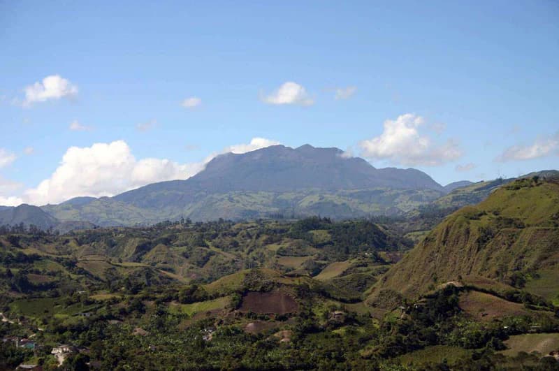
The park is distinguished primarily as a volcanic protected area harboring three named stratovolcanoes within a relatively compact territory. This volcanic complex represents a significant geological feature within the Colombian portion of the Andean volcanic belt, a region known for its high concentration of active and dormant volcanoes. The presence of three distinct volcanic centers, Doña Juana, Petacas, and Las Ánimas, within a single protected area makes this park particularly notable for geological and volcanic studies. The landscape showcases the characteristic features of stratovolcano terrain, including volcanic slopes, crater remnants, and the diverse habitats that develop on volcanic substrates.

Wide landscape view showing rolling green hills in the foreground and Doña Juana Volcano in the background under a clear blue sky with scattered clouds
Doña Juana Volcano visible in the distance with rolling hills in the foreground

Doña Juana-Cascabel Volcanic Complex National Natural Park history and protected-area timeline

The park was established on March 23, 2007, making it one of Colombia's more recently designated national parks. This establishment reflected Colombia's ongoing efforts to expand its protected areas network and provide formal conservation status to ecologically and geologically significant landscapes. The creation of the park recognized that the Doña Juana-Cascabel volcanic complex represented a natural feature of sufficient importance to warrant national-level protection within Colombia's National System of Protected Areas. Prior to formal designation, the volcanic complex likely existed as unprotected mountainous terrain used for various agricultural and pastoral activities, common throughout the Colombian Andes. The transition to protected status brought the area under the governance of SINAP, which manages Colombia's national park system.

Doña Juana-Cascabel Volcanic Complex National Natural Park landscape and geographic character

The landscape of Doña Juana-Cascabel Volcanic Complex National Natural Park is defined by its volcanic origin and Andean setting. The terrain encompasses the slopes, craters, and associated features of three stratovolcanoes that collectively form a dramatic volcanic skyline in southern Colombia. The volcanic slopes rise to elevations typical of the high Andes, with the terrain showing the characteristic patterns of volcanic landscapes including ridge lines radiating from volcanic centers, areas of older volcanic deposits, and the more rugged terrain associated with volcanic edifices. The combination of volcanic geology and high-altitude climate has shaped a landscape of considerable visual and geological interest, with the volcanic peaks providing prominent landmarks visible from surrounding lower-elevation terrain.

Doña Juana-Cascabel Volcanic Complex National Natural Park ecosystems, habitats, and plant life

The natural environment of the park reflects the intersection of high-Andean ecosystems with volcanic terrain. The volcanic soils, derived from the weathering of volcanic rocks and ash deposits, tend to be fertile and support vegetation communities adapted to the high-altitude conditions. The park lies within a biogeographic zone characterized by significant biodiversity due to the presence of multiple ecological transitions as the Andes rise from lower-elevation tropical environments to higher-elevation paramo and alpine communities. While specific botanical details are limited in available sources, the general pattern would include transitions from forest communities on lower slopes through shrubland and grassland communities at higher elevations, typical of the Andean vertical zonation.

Doña Juana-Cascabel Volcanic Complex National Natural Park wildlife and species highlights

The wildlife communities within Doña Juana-Cascabel Volcanic Complex would be expected to reflect the high-Andean character of the park's environment. The diverse habitats created by the volcanic landscape, varying elevations, and vegetation communities support characteristic Andean fauna including numerous bird species adapted to high-altitude environments, mammals ranging from smaller rodents to larger species that inhabit the Andean forests and paramo zones, and various reptile and amphibian species that thrive in the moisture-laden environments of the Colombian Andes. The presence of volcanic terrain with varied topography creates microhabitats that support biodiversity, while the protected status of the area provides refuge for species that might otherwise face habitat loss in the surrounding agricultural landscape.

Doña Juana-Cascabel Volcanic Complex National Natural Park conservation status and protection priorities

As an IUCN Category II protected area, Doña Juana-Cascabel Volcanic Complex National Natural Park benefits from formal national protection that restricts harmful activities within its boundaries. The national park designation recognizes both the geological significance of the volcanic complex and the ecological value of the Andean ecosystems it contains. Conservation of this area addresses several important objectives: protecting representative examples of Andean volcanic landscapes, preserving the biodiversity associated with high-altitude Andean environments, and maintaining the ecosystem services provided by these mountainous areas including water regulation and soil protection. The park contributes to Colombia's broader conservation network, which aims to protect the country's diverse ecological regions and the species they harbor.

Doña Juana-Cascabel Volcanic Complex National Natural Park cultural meaning and human context

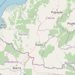
The park exists within a region of significant human presence, with the protected area boundaries encompassing municipalities in both Nariño and Cauca departments. The local communities surrounding the park maintain traditional land-use patterns typical of the Colombian Andes, including agriculture, livestock husbandry, and settlements dispersed throughout the mountain terrain. The volcanoes after which the park is named carry cultural significance as prominent landscape features that have shaped local identity and place names. The municipalities of El Tablón, San Bernardo, La Cruz, and San Pablo in Nariño Department, along with Bolívar and Santa Rosa in Cauca Department, represent the human communities situated in the vicinity of this protected volcanic landscape.

Top sights and standout views in Doña Juana-Cascabel Volcanic Complex National Natural Park

The defining highlight of Doña Juana-Cascabel Volcanic Complex National Natural Park is its status as a protected volcanic complex encompassing three named stratovolcanoes: Doña Juana, Petacas, and Las Ánimas. This concentration of volcanic centers within a single protected area provides exceptional opportunities for volcanic landscape study and appreciation. The park offers access to the distinctive scenery of Andean volcanic terrain, with the volcanic peaks serving as visual anchors for the protected landscape. The establishment of this national park in 2007 represents a relatively recent addition to Colombia's protected areas, reflecting contemporary conservation priorities that recognize the importance of preserving volcanic landscapes within the Andean region.

Best time to visit Doña Juana-Cascabel Volcanic Complex National Natural Park

While specific seasonal guidance is not readily available for this park, visitors to high-altitude Andean protected areas in Colombia generally benefit from understanding the equatorial climate patterns of the region. The Andean environment experiences relatively modest temperature variations throughout the year, with precipitation patterns being a more significant factor in visit planning. The park's high elevation means that temperatures will be cool to cold regardless of season, and visitors should prepare for the variable conditions typical of mountainous terrain.

Park location guide

Geography guide, regional context, and park location map for Doña Juana-Cascabel Volcanic Complex National Natural Park

Doña Juana-Cascabel Volcanic Complex National Natural Park park geography, regions, and map view in Colombia
Understand where Doña Juana-Cascabel Volcanic Complex National Natural Park sits in Colombia through a broader geographic reading of the surrounding landscape, nearby location context, and its mapped position within the national park landscape.

How Doña Juana-Cascabel Volcanic Complex National Natural Park fits into Colombia

Colombia is a presidential republic located in the northern part of South America. It spans approximately 1.14 million km² and has a population of around 52 million. The country features the Andes mountain range, extensive Amazon rainforest, and coastal regions on both the Caribbean and Pacific. Spanish is the official language, and Bogotá serves as the capital and largest city.

Wider geography shaping Doña Juana-Cascabel Volcanic Complex National Natural Park in Colombia

Colombia is located in the northwestern part of South America, bordering the Caribbean Sea to the north and the Pacific Ocean to the west. Its mainland neighbors are Venezuela to the east, Brazil to the southeast, Peru and Ecuador to the south and southwest, and Panama to the northwest. The terrain is diverse, featuring the Andes mountain range in the west, Amazon rainforest in the south and east, and coastal plains along both oceans.

Map view of Doña Juana-Cascabel Volcanic Complex National Natural Park

Use this park location map to pinpoint Doña Juana-Cascabel Volcanic Complex National Natural Park in Colombia, understand its exact geographic position, and read its mapped placement within the surrounding landscape more clearly.

Pigeon | © OpenStreetMap contributors

Location context for Doña Juana-Cascabel Volcanic Complex National Natural Park

Cauca DepartmentNariño Department

Explore the distinctive volcanic terrain, high-altitude scenery, and protected habitats within this prominent Colombian Andean park.

Visual Exploration of Doña Juana-Cascabel Volcanic Complex National Natural Park Landscapes
Visually explore the dramatic volcanic landscapes, stratovolcanoes, and high-altitude ecosystems of Doña Juana-Cascabel Volcanic Complex National Natural Park. These images provide essential geographic context, revealing the rugged topography and unique protected-area character of this significant Andean environment.

Wide landscape view showing rolling green hills in the foreground and Doña Juana Volcano in the background under a clear blue sky with scattered clouds

Park atlas

Map the surrounding Andean volcanic belt and compare diverse protected landscapes in Southern Colombia.

Explore Other National Parks and Protected Areas Near Doña Juana-Cascabel Volcanic Complex
Continue your exploration beyond Doña Juana-Cascabel Volcanic Complex National Natural Park by browsing a curated selection of nearby protected areas and related Andean volcanic landscapes. Discover how the region's unique high-altitude ecosystems, diverse terrain, and concentrated conservation efforts compare across neighboring Colombian national parks.
National parkColombia

Serranía de Los Churumbelos Auka-Wasi National Natural Park: Colombia's Protected Landscape Atlas

Mapped national park boundaries and regional geography.

Understand Serranía de Los Churumbelos Auka-Wasi National Natural Park through its geographic context and protected landscape features. This atlas view highlights the park's mapped boundaries and its significance within Colombia's natural geography, offering detailed insights into its protected status and regional terrain.

Area
562 km²
Established
2007
IUCN
II
Relief
Mountain
Watercolor painting of a lake with green hills and trees in the background
Protected areaNariño

La Corota Island Flora Sanctuary: A Unique Protected Area within Colombia's Nariño Region

Explore its Andean cloud forest landscape and mapped island geography.

La Corota Island Flora Sanctuary is a critical protected area in Nariño, Colombia, celebrated for its distinctive status as the country's only lake island ecosystem supporting old-growth Andean cloud forest. This compact sanctuary provides a unique landscape context, safeguarding endemic plant species and diverse birdlife within its mapped boundaries. Its presence within Laguna de la Cocha highlights a special convergence of wetland and forest geography, offering insights for atlas exploration of protected lands.

Area
0.152 km²
Established
1977
IUCN
II
Visitors
28K annual
Watercolor illustration of a mountain range with a lake in the foreground, green fields, and a colorful sky
Protected areaColombia

Galeras Protected Area: Exploring Colombia's Mapped Natural Landscapes

Discover the geography and protected terrain of Galeras.

The Galeras protected area in Colombia offers a distinct opportunity for geographic exploration, focusing on its defined boundaries and the natural landscape it encompasses. This resource details the park's setting within the Colombian geography, providing a map-centric view of its protected status. Understanding Galeras contributes to a broader appreciation of protected lands across South America and their unique terrain.

Relief
Mountain
Climate
Alpine
Access
Highly restricted
National parkCauca Department

Puracé National Natural Park: National Park Discovery and Geographic Context in Cauca Department

Explore its mapped protected landscape and regional natural geography.

Puracé National Natural Park offers a rich opportunity for geographic discovery within Colombia's Cauca Department. As a designated national park, its protected landscape serves as a key point of reference for understanding regional natural geography. This atlas-focused entry provides insight into the park's mapped boundaries and its significance as a protected area, facilitating a deeper comprehension of Colombia's conservation territories and natural terrain.

Area
830 km²
Established
1961
IUCN
II
Relief
Mountain
National parkCauca Department

Munchique National Natural Park: National Park with Key Protected Landscape Features

Explore mapped geography and protected area context.

Munchique National Natural Park is a designated National Park offering a distinct protected landscape within Colombia's Cauca Department. This page provides essential context for understanding its geographic footprint, regional setting, and its significance as a mapped natural area. Dive into the atlas details and explore the unique geography that defines this protected entity.

Area
440 km²
Established
1977
IUCN
II
Relief
Mountain
National parkEcuador

Sumaco Napo-Galeras National Park: Ecuador's Volcanic National Park Landscape

Explore protected areas and biodiversity in the Andean-Amazon transition.

Sumaco Napo-Galeras National Park protects a dramatic volcanic landscape in Ecuador, showcasing a significant elevation gradient that supports diverse cloud forest and Amazonian rainforest habitats. This national park is recognized for its endemic species and rich avifauna, offering a compelling case study for understanding protected land geography and ecological transitions within South America.

Area
2,067.49 km²
Established
1994
IUCN
II
Relief
Mountain
Watercolor painting of green hills, trees, and distant mountains under a light sky
National parkValle del Cauca Department

Farallones de Cali National Park: Protected Landscape and Geographic Atlas

Explore mapped boundaries and regional context.

Farallones de Cali National Park offers a distinct protected landscape within Valle del Cauca Department. This page provides atlas-level detail on its geographic scope and mapped features, crucial for understanding its regional context. Dive into the protected-area specifics to grasp the natural terrain and conservation landscape that defines this significant Colombian national park.

Area
1,500 km²
Established
1968
IUCN
II
Relief
Mountain
National parkValle del Cauca Department

Uramba Bahía Málaga National Natural Park: National Park Protected Landscape and Geography

Explore mapped natural terrain and protected boundaries.

Gain a detailed atlas understanding of Uramba Bahía Málaga National Natural Park, a designated national park in Colombia's Valle del Cauca Department. This page details its protected landscape features and geographic setting, offering insights into its mapped boundaries and regional context for dedicated geographic exploration.

Area
471 km²
Established
2010
IUCN
II
Climate
Tropical

Common questions about visiting, size, designation, and location context for Doña Juana-Cascabel Volcanic Complex National Natural Park

Doña Juana-Cascabel Volcanic Complex National Natural Park FAQs for park facts, access, geography, and protected area context
Find quick answers about Doña Juana-Cascabel Volcanic Complex National Natural Park, including protected-area facts, park geography, trail and visitor context, and how the park fits into its surrounding country and regional landscape.
MoriAtlas Explorer

Continue Your Protected Areas Search Across the Global Atlas

Deepen your exploration by continuing the structured search for national parks and protected areas worldwide. Utilize the comprehensive filtering capabilities to compare different conservation landscapes and refine your understanding of global park geography. Discover more about the distribution and characteristics of protected natural areas.

Global natural geography