
Mori Atlas logo
Natural monumentVelký kámen

A rugged siliceous rock formation bridging geological, archaeological, and ecological history.

Velký kámen Natural Monument and Protected Landscapes in the Plzeňský kraj Regional Atlas

Velký kámen represents a distinct protected natural monument set within the western slopes of the Plánický hřeben area in the Czech Republic. This landmark comprises a prominent 60 meter long siliceous rock outcrop surrounded by fragments of ancient beech forest. Beyond its geological significance, the site preserves evidence of Eneolithic Cham culture settlements, anchoring a unique intersection of natural terrain and regional archaeological history in the Plzeňský kraj administrative region.

natural monumentrock outcropsiliceous boulderbeech forestIUCN Category IVPlzeň Region
A stylized vector illustration of a valley between steep rock cliffs, featuring two waterfalls, a river flowing through the center, surrounding pine forest, and ferns in the foreground.

Velký kámen

Natural monument

Park overview

Structured park overview, official facts, and landscape profile for Velký kámen

Velký kámen park facts, protected area profile, and essential visitor context

Review the core facts for Velký kámen, including designation, size, terrain, visitor scale, habitats, and operating context in one park-focused overview.

About Velký kámen

Velký kámen is one of the smaller but characteristic protected natural monuments of the Klatovy District, recognized for protecting a single, well-defined geological and ecological feature rather than a broad landscape. The site centers on a prominent rock outcrop on the hill known as V Kopaninách, a long, uneven boulder formation that rises above the surrounding farmland and forest of southwestern Bohemia. Its position on a west-facing slope gives the rock and the woodland around it a particular microclimate, supporting vegetation that differs from the open agricultural surroundings.

The protected area is integrated into the broader Plánický hřeben natural park, a regional landscape protection zone that encompasses a wider stretch of forested ridges and countryside in this part of the Plzeň Region. Within this larger context, Velký kámen functions as a focused reserve, securing the integrity of the rock itself and the patches of natural forest that surround it. The site is classified as an IUCN Category IV area, a designation that reflects its role in safeguarding a particular habitat along with its characteristic geological feature.

Ecologically, the monument preserves remnants of natural beech woodland, a habitat type that has become increasingly rare and fragmented across much of the Czech agricultural landscape. These beech stands cling to the slopes around the rock and benefit from the microclimatic conditions the boulder provides. The combination of exposed rock, sheltered crevices, and surrounding forest creates habitat conditions that are distinct from the more uniform managed woodlands and fields typical of the area.

Alongside its natural values, Velký kámen is an archaeological site of regional interest. The upper portions of the boulder include three small, flat platforms that were suitable for occupation, and during the Eneolithic period (the Late Copper Age), members of the Cham culture established a hillfort settlement here. This prehistoric layer is protected as a separate cultural monument, protected since 1972, demonstrating that the site has been recognized for its layered significance for decades. The convergence of geological, ecological, and prehistoric cultural values gives Velký kámen a distinctive identity, even within a country rich in protected sites.

Quick facts and research context for Velký kámen

Velký kámen is a Czech přírodní památka (natural monument) located in the Klatovy District of the Plzeň Region, situated on the western slope of the hill V Kopaninách east of Bližanovy. It lies within the broader Plánický hřeben natural park, a regional landscape protection area in southwestern Bohemia.

The site covers a very small area of roughly 1.15 hectares at elevations around 600 to 610 meters above sea level. It is classified as an IUCN Category IV protected area, emphasizing the protection of a particular habitat alongside its defining geological feature. The monument is registered under code 499 in the Czech nature conservation database.

Protection and recognition

Terrestrial protected area records, designation history, and management scope

Velký Kámen Protection Status and Documented Conservation Scope

Velký kámen maintains structured terrestrial protection records detailing management scope and official conservation status. Verified data outlines the administrative framework governing this protected natural landscape.

Protection details

Protection scope
Terrestrial
Park context

Deeper park guide and search-rich context for Velký kámen

Velký kámen history, landscape, wildlife, and travel context

Explore Velký kámen through its history, landscape character, ecosystems, wildlife, conservation priorities, cultural context, and seasonal travel timing in a structured park guide built for atlas discovery and search intent.

Why Velký kámen stands out

Velký kámen is best known for its rugged siliceous rock outcrop, a prominent boulder-like formation roughly 60 meters long and around 30 meters wide, which dominates the local skyline and provides the site with its name. Around this rocky structure, fragments of natural beech forest have survived, adding ecological significance to what is primarily a geological landmark. The site is also notable for combining natural and archaeological values. The top of the rock contains three small flat areas once used for settlement, where a hillfort of the Cham culture from the Eneolithic period has been documented. This prehistoric occupation has been protected as a separate cultural monument since 1972, layering human history atop the natural monument's protection.
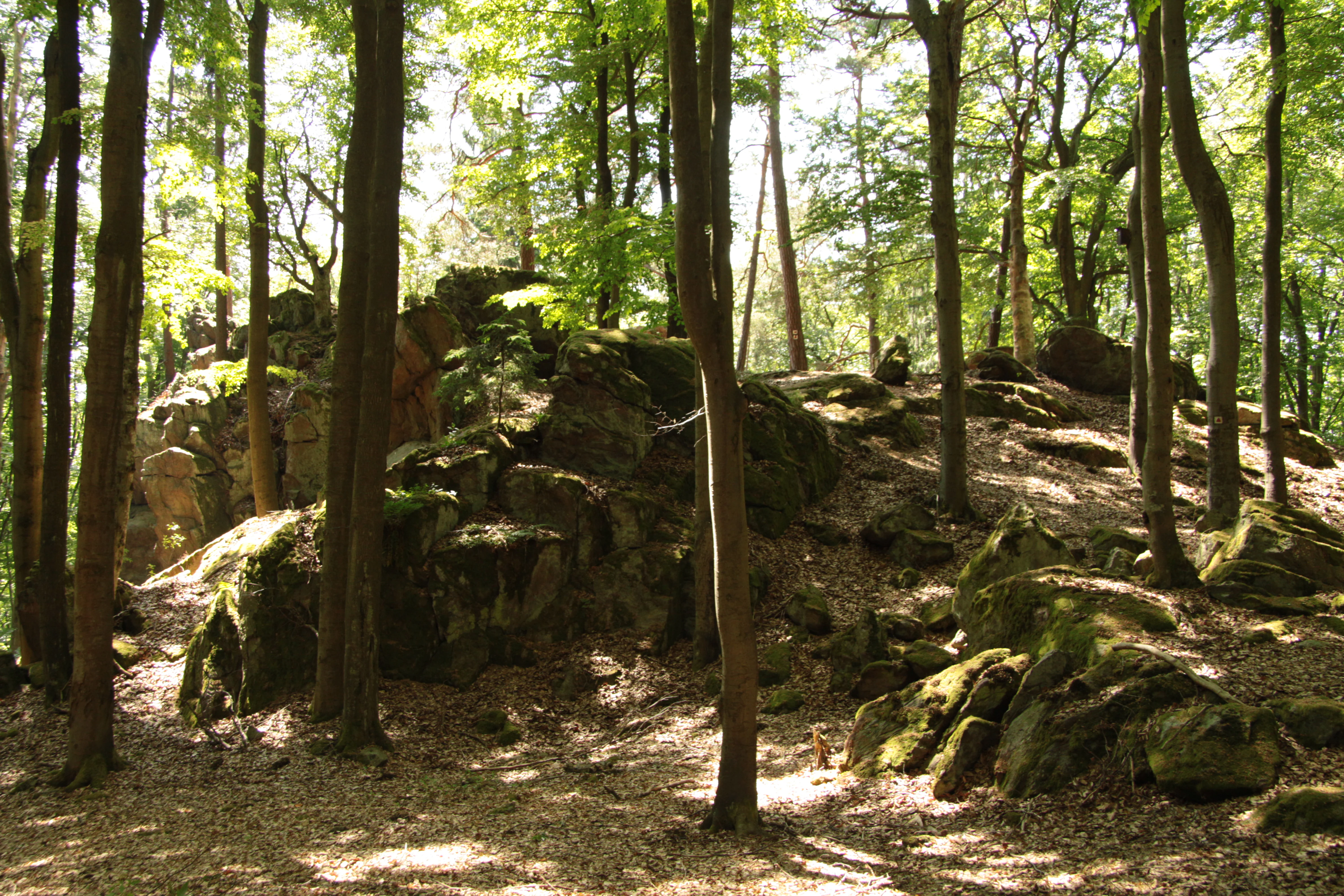
A rock formation rising from the forest floor, surrounded by tall, slender beech trees in a deciduous forest.
The distinctive rock formation at Velký kámen natural monument, surrounded by beech forest.

Velký kámen history and protected-area timeline

The landscape around Velký kámen has hosted human activity stretching back into prehistory. During the Eneolithic period, the Late Copper Age in Central European chronology, the upper portion of the rock, including its small flat platforms, supported a hillfort settlement associated with the Cham culture. The Cham culture is known in this part of Bohemia for establishing fortified hilltop sites on prominent rocky outcrops, and Velký kámen fits this broader pattern of prehistoric landscape use.

The site's more recent protection history begins with the recognition of the rock itself as a natural monument. It is registered in the Czech nature conservation system under the code 499, reflecting its long-standing status as a protected site. In modern administrative terms, Velký kámen is a přírodní památka (natural monument), a category used in the Czech Republic for smaller, focused protection of geological, ecological, or combined natural features.

In parallel, the prehistoric occupation on the rock has been legally protected as a cultural monument since 1972. This separate designation acknowledges the archaeological value of the Eneolithic hillfort and the platforms on the upper boulder. Together, the natural and cultural legal protections have ensured that the rock and its surroundings have remained relatively undisturbed, preserving both the beech forest remnants and the archaeological context.

Velký kámen landscape and geographic character

The defining feature of Velký kámen is an elongated siliceous rock outcrop, roughly 60 meters long and about 30 meters wide, that rises from the western slope of the hill V Kopaninách. The formation is uneven and broken, with multiple ledges, crevices, and small flat areas, particularly near its summit. These natural platforms are part of what made the rock attractive for prehistoric settlement and today shape the visual character of the site.

The rock is set within a west-facing slope, a position that influences both the vegetation pattern and the visual exposure of the outcrop. Below and around it, the slope transitions into woodland and then into the broader agricultural and forested mosaic of the Plánický hřeben area. The boulder itself forms a strong vertical element within an otherwise gentle Bohemian landscape, making it a recognizable local landmark visible from parts of the surrounding countryside.
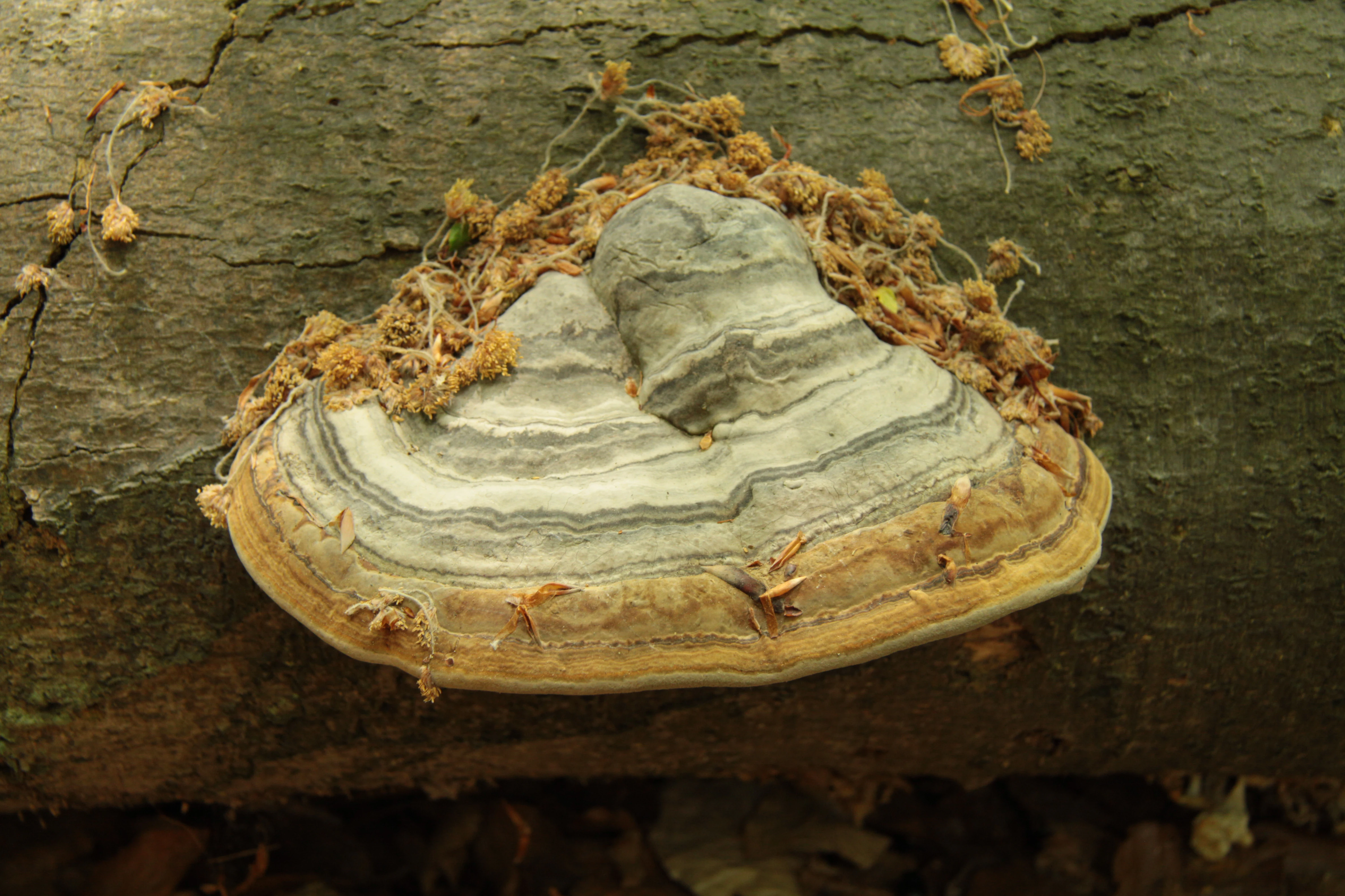
A close-up shot of a woody bracket fungus growing on the side of a fallen tree trunk, showing distinct concentric growth rings.
A bracket fungus growing on a fallen log in the beech forest of Velky Kamen.

Velký kámen ecosystems, habitats, and plant life

Velký kámen protects a small but ecologically meaningful fragment of natural beech forest on the slopes around the rock outcrop. These beech stands are remnants of more extensive forest that once covered much of this part of Bohemia, and they have survived here in part because the rocky terrain limited agricultural conversion and intensive forestry. The combination of the boulder with the surrounding forest creates a mosaic of microhabitats that supports the distinctive character of the site.

The site is classified under IUCN Category IV as a Species Management Area, a designation that highlights the importance of conserving particular habitat components alongside the geological feature. While the area is very small, the local microclimate around the rock, shaped by slope orientation, exposure, and the thermal behavior of the boulder, contributes to habitat conditions that differ from the surrounding matrix of fields and planted woodland.
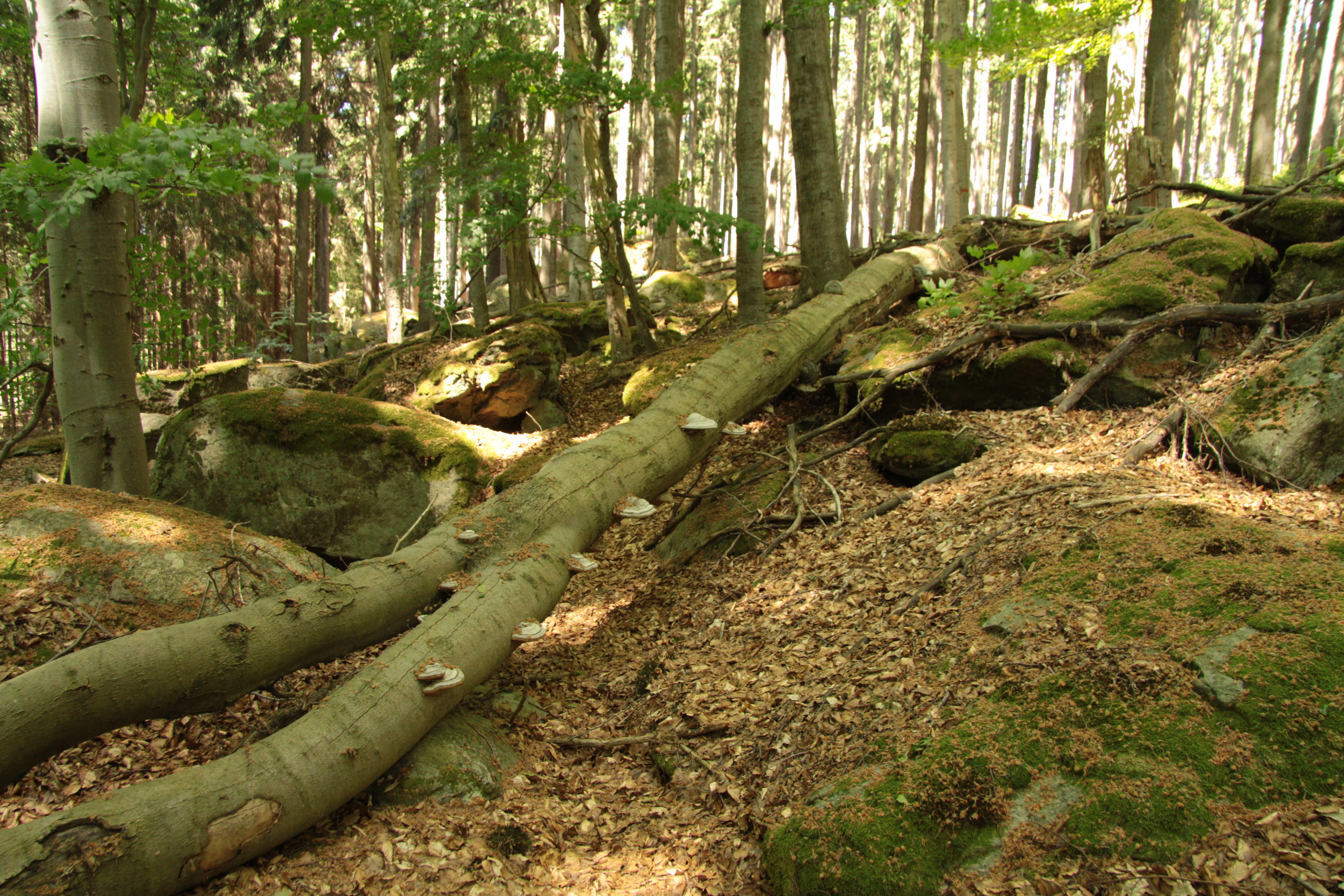
A forest floor with large moss-covered boulders and a fallen tree trunk stretching across the scene.
A view of the beech forest landscape and rock formations within the Velký kámen nature monument.

Velký kámen conservation status and protection priorities

The central conservation value of Velký kámen lies in the protection of a specific rocky habitat and the natural beech forest fragments associated with it. As an IUCN Category IV protected area, the site is managed primarily to maintain these habitat conditions rather than to accommodate broad public use. The 1.15-hectare size reflects a focused approach, concentrating protection on the rock itself and the most ecologically significant vegetation around it.

By being embedded in the larger Plánický hřeben natural park, Velký kámen also contributes to a broader network of landscape-level protection in the Plzeň Region. The juxtaposition of two protection tiers, regional landscape protection for the surrounding countryside and site-specific natural monument status for the rock and its woodland, reflects an integrated approach to conserving geological, ecological, and cultural values together. The presence of additional cultural monument protection for the prehistoric hillfort on the same rock reinforces the long-standing recognition of this layered significance.

Velký kámen cultural meaning and human context

Velký kámen has a clear prehistoric cultural dimension through its association with the Cham culture of the Eneolithic period. The flat platforms on the upper portions of the boulder provided natural defensive positions suitable for a hillfort settlement, and the site's occupation during this era places it within the wider tradition of Cham culture hillforts established on prominent rocky outcrops across parts of Bohemia.

This archaeological significance has been formally recognized since 1972, when the site was listed as a cultural monument, a separate designation from its natural monument status. The dual protection reflects how the rock serves as both a natural landmark and a documented location of prehistoric human activity, embedding the site within the broader prehistoric and cultural heritage of the Klatovy District and the Plzeň Region.

Top sights and standout views in Velký kámen

The standout features of Velký kámen are concentrated in a compact footprint. The elongated siliceous rock formation, roughly 60 meters long and 30 meters wide, provides the site's defining geological identity and gives the monument its name. Around it, remnants of natural beech forest add ecological significance, while the upper platforms of the rock carry evidence of an Eneolithic hillfort of the Cham culture, broadening the site's interest beyond its natural features.

The integration of Velký kámen within the Plánický hřeben natural park, combined with its separate cultural monument status, illustrates how the site bridges geological, ecological, and archaeological values in a single small location. Despite its modest size, the layering of these values makes it a distinctive protected site in the Czech protected-area system.

Monthly climate preview

Long-term temperature and precipitation patterns sampled from representative park coordinates

Velký kámen Climate Normals and Measured Annual Weather by Month

Historical climate records for Velký kámen document a measured annual progression of monthly average temperatures and daily precipitation rates based on coordinates at a 527-meter elevation. Examining the complete twelve-month profile provides deeper analytical insight into multi-year meteorological averages across the protected terrain.
Annual mean8 °C
-3 °C19 °C
Jan-3°
Feb-2°
Mar
Apr
May12°
Jun16°
Jul19°
Aug18°
Sep13°
Oct
Nov
Dec-2°
Warmest month
July

18.5 °C

Coolest month
January

-2.8 °C

Wettest month
June

2.9 mm/day

Driest month
February

1.4 mm/day

Park location guide

Geography guide, regional context, and park location map for Velký kámen

Velký kámen park geography, regions, and map view in Czechia

Understand where Velký kámen sits in Czechia through a broader geographic reading of the surrounding landscape, nearby location context, and its mapped position within the national park landscape.

How Velký kámen fits into Czechia

Czech Republic is a landlocked Central European country with a population of approximately 10.9 million people. The nation was established as an independent state on January 1, 1993, following the dissolution of Czechoslovakia. Its capital and largest city is Prague, with other major urban centers including Brno, Ostrava, Plzeň, and Liberec.

Wider geography shaping Velký kámen in Czechia

The Czech Republic is a landlocked country in Central Europe. It is bordered by Germany to the west, Austria to the south, Poland to the northeast, and Slovakia to the southeast. The landscape is predominantly hilly, with the territory covering 78,871 square kilometers.

Map view of Velký kámen

Use this park location map to pinpoint Velký kámen in Czechia, understand its exact geographic position, and read its mapped placement within the surrounding landscape more clearly.

Pigeon | © OpenStreetMap contributors

Location context for Velký kámen

Plzeňský kraj

Visual reference collection highlighting geological terrain, beech forest fragments, and landscape character.

Velký Kámen Photos and Scenery: Exploring the Protected Rock Outcrop and Woodland Habitats

Photographic records reveal the rugged siliceous rock formation and surrounding natural beech forest that define the protected landscape of Velký Kámen. Visual examination of the terrain and vegetation provides deeper insight into the ecological and geological features of this protected monument.

A rock formation rising from the forest floor, surrounded by tall, slender beech trees in a deciduous forest.

A large, rugged rock outcrop rises in the center of a dense forest with tall tree trunks, with forest floor covered in leaves and debris.

A close-up shot of a woody bracket fungus growing on the side of a fallen tree trunk, showing distinct concentric growth rings.

A forest floor with large moss-covered boulders and a fallen tree trunk stretching across the scene.

Park atlas

Compare adjacent geological formations and regional conservation areas

Explore Parks Near Velký Kámen and Surrounding Protected Landscapes

Visitors exploring Velký kámen can browse other nearby protected areas, matching regional geography and geological formations across the surrounding countryside. Continuing through these related natural monuments expands regional terrain comparison and deepens understanding of local conservation landscapes.
A horizontal watercolor painting showing rolling green hills, scattered trees, and soft mountain silhouettes in the distance against a white background.
Protected landscapePlzeňský kraj
About 12 km away#1 closest

North

Přírodní park Buková hora, Chýlava: Geographic Atlas and Protected Landscape Overview

Forested uplands and industrial heritage in western Bohemia.

Focusing on the 28 square kilometer expanse of Přírodní park Buková hora, Chýlava, this overview details the park's acidophilous oak forests, sedimentary bedrock, and inclusion of the Chejlava National Nature Reserve. Understand the site's role as a protected upland framed by the Úslava watershed and historic mining settlements in the Plzeňský kraj region.

Area
28 km²
Established
1983
Relief
Upland
Climate
Temperate
A horizontal watercolor painting showing rolling green hills and distant purple ridges against a white background.
Protected landscapeKlatovy District
About 16 km away#2 closest

South

Přírodní park Buděticko: Protected Landscape and Geographic Atlas of Klatovy District

Orchid-rich meadows and riparian terrain in the Bohemian foothills

Přírodní park Buděticko serves as a vital protected landscape in the Klatovy District, characterized by the transition between the Šumava foothills and broader upland plains. This area supports a mosaic of orchid-rich limestone meadows and riparian habitats along the Otava River. Discover the park's geological character and its integration of natural biodiversity with the cultural heritage of southwestern Bohemia.

Area
44 km²
Established
1994
Relief
Upland
Climate
Temperate
A horizontal watercolor illustration depicting soft, rolling hills in shades of green, yellow, and light pink with small clusters of trees.
Nature reservePlzeňský kraj
About 17 km away#3 closest

Southeast

Prácheň Nature Reserve: Protected Broadleaf Woodlands and Historic Castle Remains

An atlas view of Bohemian forest geography and heritage landscapes

Prácheň Nature Reserve protects a compact block of warm-loving deciduous woodland set atop a hilltop in the Plzeňský kraj region. The area integrates significant natural habitats with cultural heritage, encompassing an early medieval hillfort and castle ruins. This unique blend of forest ecology and Bohemian historical geography offers a distinct perspective on protected areas within the southwestern Czech landscape.

Area
0.283 km²
Established
1953
IUCN
IV
Relief
Upland
A watercolor painting showing a panoramic view of soft rolling green hills, a small stream, and wildflowers in the foreground.
Natural monumentJihočeský kraj
About 21 km away#4 closest

East

Smyslov Natural Monument: Mapping Protected Habitats in the South Bohemian Region

Traditional pastoral landscapes and botanical meadow mosaics

Smyslov stands as a significant natural monument in the Jihočeský kraj, illustrating the traditional ecological structure of the Blatná area. The site is defined by its tight combination of dry, rocky slopes featuring juniper, and shallow depressions hosting moisture-loving vegetation. Explore this distinct protected area to understand its role in conserving rare meadow flora and traditional South Bohemian terrain.

Area
0.078 km²
Established
1990
IUCN
IV
Relief
Lowland
Watercolor illustration of a river flowing through a forested landscape with rolling hills in the background
National parkSouth Bohemian Region
About 29 km away#5 closest

South

Šumava National Park: Czech Republic's Premier Forested National Park and Protected Landscape

Explore the unique glacial lakes, peat bogs, and regional geography.

Šumava National Park, situated in the South Bohemian Region of the Czech Republic, is the nation's largest protected area and a vital component of Central Europe's forest ecosystems. This entry details its expansive terrain, highlighting the significant peat bog complexes and ancient glacial lakes that define its unique landscape. Discover the park's geographic context, mapped boundaries, and its importance as a protected natural asset within the broader regional atlas.

Area
680.64 km²
Established
1991
IUCN
II
Visitors
2M annual
A horizontal watercolor painting depicting a soft, atmospheric landscape with a foreground of purple and pink wetland grasses, a midground of scattered green coniferous trees, and hazy, distant mountain silhouettes in the background.
Nature reservePlzeňský kraj
About 31 km away#6 closest

Southwest

Prameniště Nature Reserve: Protected Wetland and Mountain Spring Systems in Plzeňský kraj

Mapping the hydrological headwaters of the Šumava Mountains

Prameniště Nature Reserve represents a critical cluster of protected mountain springs and peat bogs across the Pancířský hřbet ridge. By focusing on the source areas for the Křemelná and Řezná rivers, this reserve maintains essential hydrological integrity within the wider Plzeňský kraj landscape. Its mosaic of sub-alpine peatlands and montane spruce forests provides an important study of high-altitude wetland geography in the central European mountains.

Area
3.536 km²
Established
1994
IUCN
IV
Relief
Mountain
A watercolor painting of soft green rolling hills and small clusters of pine trees against a light sunset sky.
Natural monumentJihočeský kraj
About 31 km away#7 closest

Southeast

Ryšovy Natural Monument and Botanical Protected Area in Jihočeský kraj

Exploring limestone woodland terrain and rare floral habitats

Ryšovy is a notable natural monument in the Czech Republic, defined by its characteristic limestone bedrock and the resulting diverse herb layer. This protected area creates a significant botanical stronghold within the wider landscape of the Jihočeský kraj, featuring a mosaic of woodland patches and sun-exposed clearings that support protected orchids and other rare thermophilous plant species.

Area
0.35 km²
Established
1990
IUCN
IV
Relief
Upland
Watercolor painting of a grassy meadow bordered by a forest line with soft green and muted earth tones.
Nature reserveJihočeský kraj
About 36 km away#8 closest

South

Rašeliniště u Martinala: A Protected Nature Reserve in the Jihočeský kraj Foothills

Mapping transitional bog ecosystems and submontane habitats

Located in the Šumava foothills, Rašeliniště u Martinala is a protected nature reserve defined by its dual-parcel structure of peat-forming wetlands and juniper-rich dry grasslands. This site acts as a key ecological node, supporting a high density of protected species within the Jáchymovský potok drainage basin and representing a refined example of south Bohemian submontane landscape character.

Area
0.095 km²
Established
2011
IUCN
IV
Relief
Upland

Common questions about visiting, size, designation, and location context for Velký kámen

Velký kámen FAQs for park facts, access, geography, and protected area context

Find quick answers about Velký kámen, including protected-area facts, park geography, trail and visitor context, and how the park fits into its surrounding country and regional landscape.
MoriAtlas Explorer

Continue Your Protected Areas Search Across the Global Atlas

Deepen your exploration by continuing the structured search for national parks and protected areas worldwide. Utilize the comprehensive filtering capabilities to compare different conservation landscapes and refine your understanding of global park geography. Discover more about the distribution and characteristics of protected natural areas.

Global natural geography