
Mori Atlas logo
Natural monumentVinice

Tracing the ancient stratigraphic profile and xeric habitats above the Litavka River valley

Vinice Natural Monument: A Geological and Ecological Atlas of the Jince Formation in Czechia

(Vinice (přírodní památka))

Vinice Natural Monument stands as a critical geological landmark in the Central Bohemian Region of Czechia. This protected area preserves a unique stratigraphic profile of the Jince Formation, offering rare insight into 520 million years of Cambrian marine history through exposed shales and siltstones. Beyond its internationally significant fossil records, the terrain encompasses a diverse mosaic of acidophilous oak forests and xeric grasslands that characterize the transition between the Litavka valley and the Brdy highlands.

natural monumentCzech RepublicCentral Bohemian RegionJinceBrdy highlandsCambrian fossils
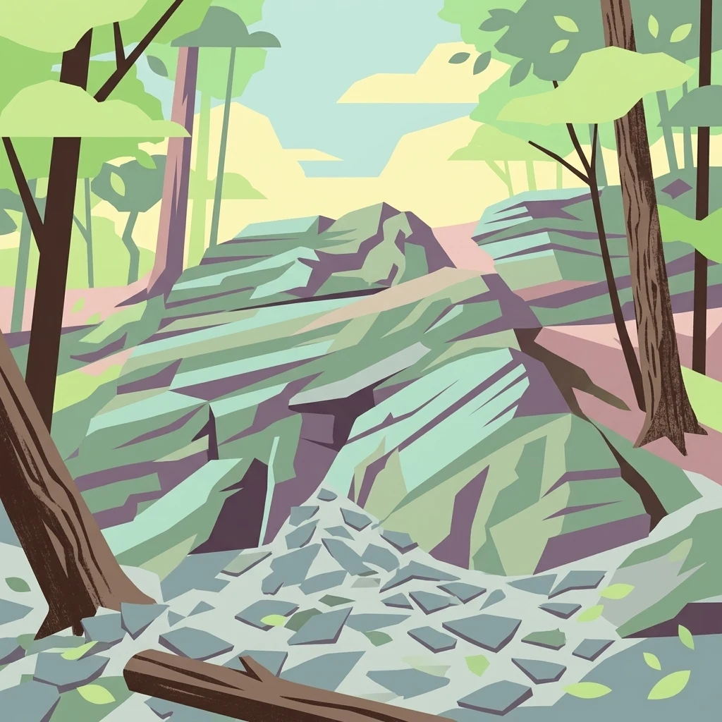
A graphic illustration showing a rocky terrain in a forest with trees and a debris-covered ground.

Vinice

Natural monument

Park overview

Structured park overview, official facts, and landscape profile for Vinice Natural Monument

Vinice Natural Monument park facts, protected area profile, and essential visitor context

Review the core facts for Vinice Natural Monument, including designation, size, terrain, visitor scale, habitats, and operating context in one park-focused overview.

About Vinice Natural Monument

Vinice is a small but globally significant natural monument situated on the lower slopes of the Brdy highlands, overlooking the Litavka River near the town of Jince in the Příbram district. Although the protected area covers just over 42 hectares, it concentrates a remarkable combination of geological, paleontological, and ecological values within a single compact landscape.

The defining feature of the site is the natural exposure of mid-Cambrian sedimentary rocks belonging to the Jince Formation. These strata were laid down roughly 520 million years ago, when a shallow sea covered this part of what is now Bohemia. Over geological time, uplift and erosion brought these ancient marine sediments back to the surface, and the Litavka valley has slowly cut down through them, exposing one of the most studied Cambrian sections in the world.

Beyond its paleontological importance, Vinice protects a distinctive mosaic of warm, dry habitats shaped by its southwesterly exposure and poor, shallow soils. Acidophilous oak woodlands dominated by sessile oak cover much of the area, with oak-hornbeam communities appearing on moister parts of the slope and open xeric vegetation clinging to the steepest, rockiest outcrops. The result is a protected area where scientific heritage, ancient fossils, and living Central European forest and steppe habitats meet in a single, easily accessible landscape.

Quick facts and research context for Vinice Natural Monument

Vinice is a Czech přírodní památka, a national designation for smaller protected natural monuments under IUCN category III. It was established by the District Office in Příbram on 30 April 1999 and now falls under the administration of the Central Bohemian Regional Authority.

The protected area covers 42.18 hectares of forested terrain on a rocky slope overlooking the Litavka River, between elevations of 372 and 506 metres. It lies within the cadastral territories of Běřín and, in part, Jince and Čenkov u Příbramě, and is crossed by the educational trail from Jince to the Brdy highlands.

Protection and recognition

Terrestrial protected area records and official recognition data

Vinice Protection Status and Documented Conservation Framework

Vinice maintains structured terrestrial protection status records detailing administrative scope and environmental governance. Official recognition data compiles baseline conservation metrics and verified geographical parameters for the protected area.

Protection details

Protection scope
Terrestrial
Transboundary protection
No
WDPA ID
2068
Park context

Deeper park guide and search-rich context for Vinice Natural Monument

Vinice Natural Monument history, landscape, wildlife, and travel context

Explore Vinice Natural Monument through its history, landscape character, ecosystems, wildlife, conservation priorities, cultural context, and seasonal travel timing in a structured park guide built for atlas discovery and search intent.

Why Vinice Natural Monument stands out

Vinice is best known for its Cambrian stratigraphic section and exceptionally rich trilobite fauna. The exposed rocks of the Jince Formation, deposited when the region lay beneath a shallow Cambrian sea, preserve a continuous record of biostratigraphic zones that has been studied since the late 18th century. The locality is internationally famous through the work of geologist Joachim Barrande in the 19th century and continues to attract scientific interest for its trilobite genera, most notably Paradoxides and Hydrocephalus, as well as brachiopods, bivalved arthropods, echinoderms, molluscs, primitive algae, hyoliths, and other Cambrian marine organisms.
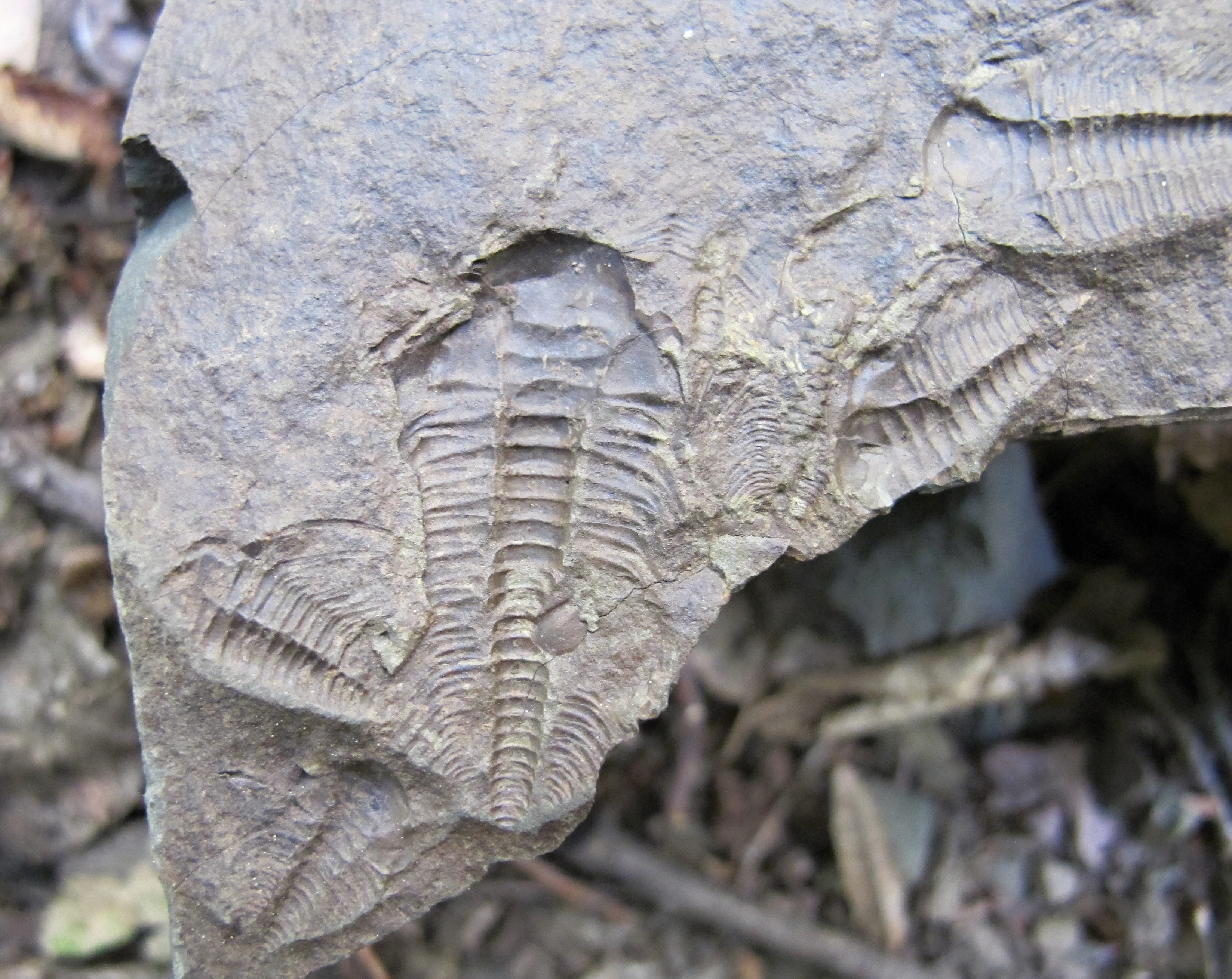
Close up view of multiple trilobite fossil impressions embedded in a piece of grey sedimentary rock.
Trilobite fossil impressions found at the Vinice natural monument.

Vinice Natural Monument history and protected-area timeline

The broader Brdy highlands and the Hřebeny ridge have been inhabited since prehistoric times, with archaeological evidence from the Mesolithic, Neolithic, and Eneolithic periods documented at the nearby hill of Plešivec. The Litavka valley served as an important transit corridor across the highlands for thousands of years.

From the late 18th century, the area underwent significant industrial change driven by ironworking. Ironmaking, recorded in the region as early as 1390, expanded rapidly in the 1700s and led to local deforestation. At Vinice specifically, historical records suggest that timber, quartzite, and possibly iron ore were extracted. Between 1806 and 1852, an attempt was reportedly made to grow grapevines on the site, which is thought to explain the place name Vinice, meaning vineyard, although the poor soils and lack of moisture made viticulture unsuccessful.

The scientific story of the site began in the second half of the 18th century, when its fossil-rich rocks attracted naturalists. In the 19th century, the eminent geologist and palaeontologist Joachim Barrande conducted detailed studies of the Cambrian fossils at Vinice, helping to establish the locality as one of the world's most important Cambrian reference sections. The growing threat of unregulated fossil collecting, combined with pressure on the surrounding vegetation, ultimately led the Příbram District Office to formally protect the area as a přírodní památka on 30 April 1999.

Vinice Natural Monument landscape and geographic character

Vinice occupies a steep, rocky, southwest-facing slope on the right bank of the Litavka River, just upstream of the town of Jince. The protected area rises from roughly 372 metres above sea level at the river margin to about 506 metres at the upper edge, looking out toward the Brdy highlands.

Geologically, the slope is defined by the exposed Jince Formation, a sequence of Cambrian sedimentary rocks. The oldest visible layers consist of yellowish-grey and brownish siltstones and sandstones, overlain by greenish-grey, hard greywacke shales. Ordovician tuffites and very hard quartzites also appear within the section. Soils across the site are shallow and nutrient-poor, reinforcing the dry, open character of the most exposed parts of the slope.

The terrain is broken by rock outcrops, scree, and small cliffs, with the steepest sections supporting open xeric vegetation and the more stable parts clothed in woodland. A 17.3-kilometre educational trail running from Jince toward the Brdy highlands passes through the monument, allowing visitors to experience the transition from the warm Litavka valley into the cooler uplands of Brdy.
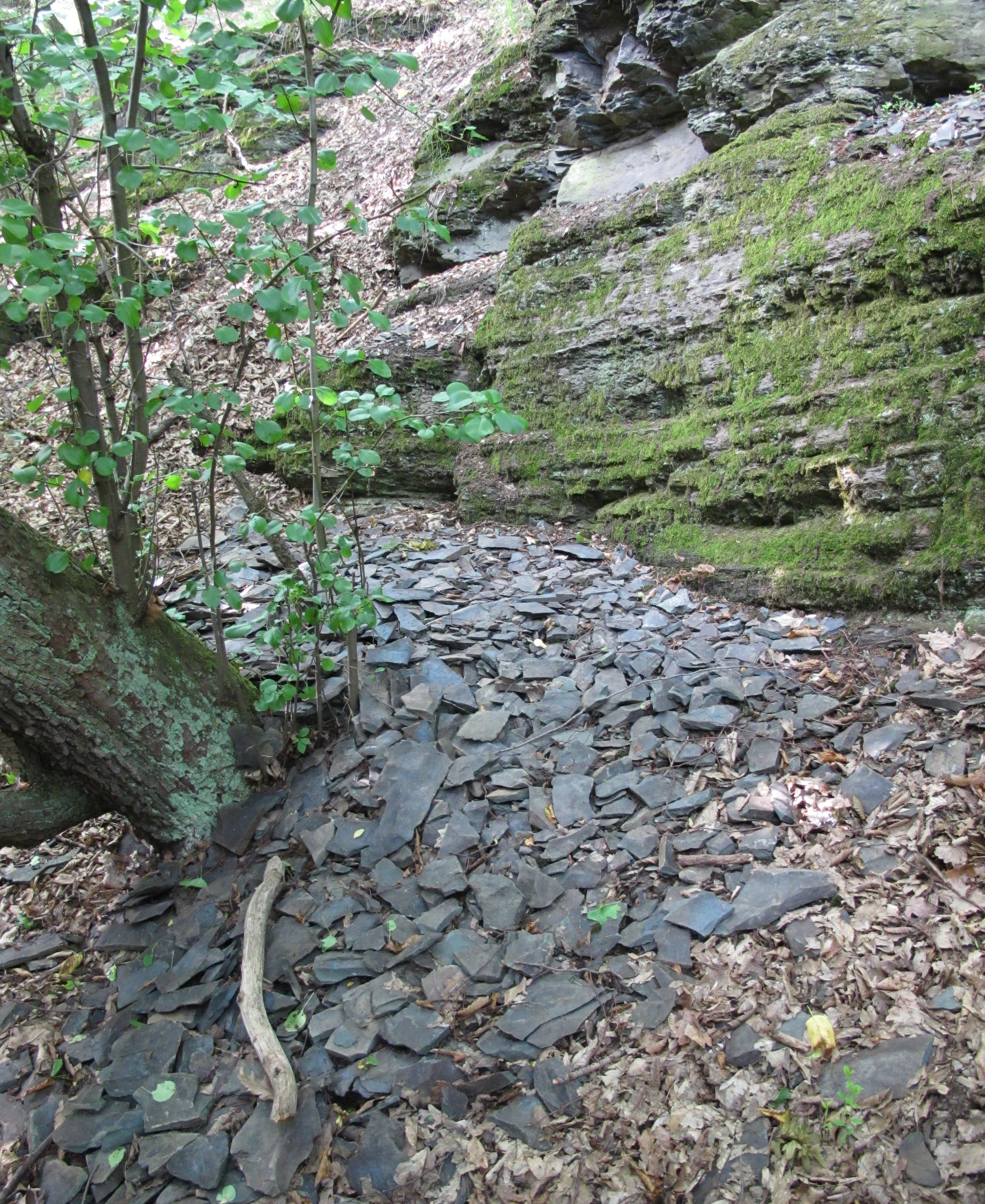
A close up view of layered, moss-covered rock outcrops and a ground covered in fragmented shale and fallen leaves in a wooded area.
Exposed shale and rock outcrops at the Vinice natural monument.

Vinice Natural Monument ecosystems, habitats, and plant life

Ecologically, Vinice sits within the Czech mesophytic vegetation zone, but the warm, dry character of the Litavka valley allows thermophilous, or heat-loving, plant communities to flourish locally, creating what ecologists describe as a local thermophytic enclave.

The dominant woodland type across much of the monument is a species-poor acidophilous oak forest belonging to the Luzulo albae-Quercetum association, with a ground layer shaped by sheep's fescue and other grasses tolerant of acidic soils. On more balanced soils these forests transition into oak-hornbeam woodland of the Melampyro-Carpinetum subtype, where shade-tolerant herbs such as European sanicle, spring pea, and liverleaf appear.

The steepest, rockiest sections support open xeric grassland with scattered shrubs and protected species such as the Bohemian pasqueflower. Bracken and spleenwort ferns colonise rock crevices, while small patches of hornbeam woodland with large-flowered stitchwort occupy the more shaded parts of the slope.

Vinice Natural Monument wildlife and species highlights

Vinice is primarily a geological and botanical site, but the mosaic of woodland, dry grassland, and the adjoining Litavka River corridor supports a varied, albeit typical, Bohemian fauna.

Historical records suggest that the critically endangered garden dormouse once occurred in the area, although it is not a conspicuous species today. The wider Litavka river basin supports the Eurasian otter, an important conservation presence in the region. Common woodland mammals such as roe deer, European hare, red squirrel, and wild boar still inhabit the protected area.

Among invertebrates, forest dung beetles are characteristic ground-dwelling insects, while the invasive Asian ladybeetle has become established in the canopy layer. The greater significance of the fauna, however, lies in the fossilised Cambrian marine life preserved in the rocks, including trilobites, bivalved arthropods, echinoderms, brachiopods, molluscs, hyoliths, and traces of primitive algae, which together form one of the richest early Palaeozoic marine fossil assemblages in Europe.

Vinice Natural Monument conservation status and protection priorities

The core conservation value of Vinice lies in the international scientific importance of its Cambrian stratigraphic profile. The exposed rock section is considered irreplaceable for studying the biostratigraphy of the Jince Formation, and protection status was granted in 1999 largely to safeguard this geological heritage.

A persistent threat is unregulated and illegal collection of trilobites and other fossils by amateur collectors, which damages the rock exposure and the surrounding vegetation. Conservation managers have called for legislation to ban the sale of Jince Formation fossils and for closer coordination with criminal police authorities to combat organised fossil trafficking.

Forest management at the site is deliberately low-impact. Most of the area is left to develop without intervention, while selective harvesting is carried out elsewhere to control Scots pine, Norway spruce, and invasive black locust. Selective thinning of shrubs on some of the warmer slopes is also used to maintain the open character of xerothermic plant communities.

Vinice Natural Monument cultural meaning and human context

The cultural context of Vinice is shaped by long-standing human use of the Litavka valley and the surrounding Brdy highlands. The valley historically functioned as a major route across the otherwise forested Brdy massif, supporting trade, communication, and resource extraction from at least the Bronze Age onward.

The most distinctive local cultural trace is the name Vinice itself, meaning vineyard in Czech, which local tradition links to an unsuccessful attempt at viticulture between 1806 and 1852. The nearby hill of Plešivec preserves archaeological evidence of Mesolithic, Neolithic, and Eneolithic settlement, while the industrial history of the broader region is anchored in centuries of ironmaking documented from the late 14th century and expanding dramatically in the 18th century.

Top sights and standout views in Vinice Natural Monument

Outstanding Cambrian stratigraphic profile of the Jince Formation, internationally recognised in geological research. One of Europe's most important fossil trilobite sites, with historical research by Joachim Barrande linking it to 19th-century palaeontological traditions. A compact palette of Bohemian habitats on a single south-facing slope, from acidophilous oak woodland and oak-hornbeam stands to open xeric grassland. Strong educational value through the 17.3-kilometre educational trail from Jince into the Brdy highlands that passes directly through the monument.

Best time to visit Vinice Natural Monument

Vinice is open year-round as a protected landscape site, and visit timing depends largely on what visitors hope to experience. Spring is ideal for seeing thermophilous wildflowers such as the Bohemian pasqueflower and a range of forest herbs in the oak-hornbeam stands, while early summer offers rich insect activity and full leaf cover across the woodland.

Autumn is a particularly rewarding season for appreciating both the warm colour palette of the oak-dominated forests and the visibility of the Cambrian rock outcrops once undergrowth dies back. Winter visits emphasise the contrast between the snow-dusted slopes and the exposed Cambrian cliffs, allowing the geology to stand out clearly.

Monthly climate preview

Long-term representative coordinate records detailing weather by month for Vinice

Vinice Climate Normals, Annual Temperature and Monthly Precipitation Rhythms

Representative coordinates track measured monthly temperature swings and precipitation patterns across the elevation profile of Vinice. Complete twelve-month climate tables provide detailed long-term averages for analyzing annual meteorological trends.
Annual mean8 °C
-2 °C19 °C
Jan-2°
Feb-1°
Mar
Apr
May13°
Jun17°
Jul19°
Aug19°
Sep14°
Oct
Nov
Dec-1°
Warmest month
July

19.2 °C

Coolest month
January

-2.4 °C

Wettest month
June

2.6 mm/day

Driest month
February

1.1 mm/day

Park location guide

Geography guide, regional context, and park location map for Vinice Natural Monument

Vinice Natural Monument park geography, regions, and map view in Czechia

Understand where Vinice Natural Monument sits in Czechia through a broader geographic reading of the surrounding landscape, nearby location context, and its mapped position within the national park landscape.

How Vinice Natural Monument fits into Czechia

Czech Republic is a landlocked Central European country with a population of approximately 10.9 million people. The nation was established as an independent state on January 1, 1993, following the dissolution of Czechoslovakia. Its capital and largest city is Prague, with other major urban centers including Brno, Ostrava, Plzeň, and Liberec.

Wider geography shaping Vinice Natural Monument in Czechia

The Czech Republic is a landlocked country in Central Europe. It is bordered by Germany to the west, Austria to the south, Poland to the northeast, and Slovakia to the southeast. The landscape is predominantly hilly, with the territory covering 78,871 square kilometers.

Map view of Vinice Natural Monument

Use this park location map to pinpoint Vinice Natural Monument in Czechia, understand its exact geographic position, and read its mapped placement within the surrounding landscape more clearly.

Pigeon | © OpenStreetMap contributors

Explore detailed imagery of rocky slopes, woodland habitats, and geological formations across the protected landscape.

Vinice Photos and Landscape Scenery, Visualizing the Protected Area Environment

Visual documentation of Vinice reveals the rugged terrain, steep rock outcrops, and varied natural habitats defining the protected slope. Examining authentic park photography provides clear insight into the regional environment and geological character of the Litavka valley.

Close up view of multiple trilobite fossil impressions embedded in a piece of grey sedimentary rock.

A view of dark, layered rock outcrops surrounded by a deciduous forest, with the forest floor covered in fallen leaves.

A close up view of layered, moss-covered rock outcrops and a ground covered in fragmented shale and fallen leaves in a wooded area.

Park atlas

Compare adjacent geological monuments and regional nature reserves across the Brdy highlands.

Explore Protected Areas Near Vinice and Surrounding Central Bohemian Landscapes

Browse nearby national parks and protected landscapes to continue examining the regional geology of the Litavka valley. Extending your search reveals connected terrain features and related conservation areas throughout Central Bohemia.
A horizontal watercolor illustration depicting rolling green hills, scattered trees, and foreground flowers with soft mountains in the distance.
Nature reserveStředočeský kraj
About 3.1 km away#1 closest

Northwest

Na horách Nature Reserve: Geographic Context and Protected Landscape Discovery

Středočeský kraj, Czech Republic

Na horách serves as a protected landmark for thermophilous vegetation within the Brdy Highlands. This nature reserve provides a clear window into how skeletal soils and historic land management sustain unique dry-grassland plant assemblages across a sloping, varied Bohemian terrain.

Area
0.049 km²
Established
1997
IUCN
IV
Relief
Upland
A watercolor illustration of a rolling forest landscape with soft green ridgelines and hazy, pale hills in the background.
Protected landscapeCentral Bohemian Region
About 13 km away#2 closest

Northeast

Přírodní park Hřebeny: Geographic Overview of the Central Bohemian Forested Ridge

Mapped protected landscape and regional upland terrain

Analyze the territorial structure of Přírodní park Hřebeny, a vast protected area in the Czech Republic covering 184 square kilometers. This detailed overview covers the park's ridgeline geography, forested composition including beech and mixed stands, and its strategic placement within the broader landscape of the Central Bohemian Region.

Area
184 km²
Established
2009
Relief
Mountain
Climate
Temperate
A wide watercolor illustration showing a winding river, a line of green trees, and soft rolling hills in pastel green, pink, and purple tones against a white background.
Natural monumentStředočeský kraj
About 26 km away#3 closest

Northwest

Skryjsko-týřovické kambrium: A Scientific Natural Monument and Geological Landmark

Paleontological heritage in the central Bohemian hills.

Skryjsko-týřovické kambrium provides essential protection for fossil-bearing Cambrian strata in the Czech Republic. This landmark, managed as a natural monument within the Středočeský kraj, remains a foundational reference site for international researchers exploring early Paleozoic marine life, characterized by its unique rock outcrops along the Berounka river valley.

Area
0.3 km²
Established
2011
IUCN
IV
Relief
Upland
A watercolor illustration of a rolling, green landscape with distant, faint hills and small ponds or water bodies in the foreground.
Natural monumentPlzeňský kraj
About 29 km away#4 closest

West

Rokycanská stráň Natural Monument: Geological Exposures and Regional Protected Landscapes

Stratigraphic reference site in the Plzeňský kraj, Czech Republic

Rokycanská stráň represents a key geological protected area situated on the outskirts of Rokycany. The site protects the Klabava Formation stratotype and fossil-rich shales, functioning as a benchmark for Ordovician geology in the Barrandian area. Its four distinct parcels illustrate the interface between urban development and important paleontological research sites in the Plzeň region.

Area
0.208 km²
Established
1981
IUCN
IV
Relief
Upland
Natural monumentCentral Bohemian Region
About 30 km away#5 closest

Northwest

Valachov Natural Monument: Geological and Historical Landscape Analysis in Central Bohemia

Mineralogical type locality and industrial-archaeological protected area.

Valachov is a small yet significant natural monument located in the Central Bohemian Region, serving as the primary type locality for the mineral slavíkit. Beyond its mineralogical importance, the hill preserves physical evidence of medieval lead and nineteenth-century pyrite mining, including shafts and adits embedded within a diverse forested ecosystem of the Křivoklátsko protected landscape area.

Area
0.03 km²
Established
1977
IUCN
III
Relief
Upland
Watercolor painting of a rolling Czech landscape featuring meadow flowers in the foreground, forest in the midground, and distant hazy hills.
Natural monumentStředočeský kraj
About 31 km away#6 closest

North

Markův mlýn Natural Monument: Exploring the Geography and Protected Flora of Central Bohemia

A rare botanical reserve featuring unique rock-steppe plant communities

Markův mlýn is a protected natural monument situated in the Středočeský kraj region, characterized by its rare combination of dry, thin-soil hillside meadows and stream-influenced valley terrain. The area serves as a critical habitat for specialized steppe flora, including the protected Bohemian pasqueflower. This record offers a detailed look at the site's compact geography and the specific environmental conditions that sustain its unusual plant communities.

Area
0.001 km²
Established
1987
IUCN
III
Relief
Lowland
Natural monumentPrague
About 34 km away#7 closest

Northeast

Zmrzlík Natural Monument: Geological Profile and Protected Landscape Map of Prague

Silurian stratotype sites and calcareous grassland ecosystems

Zmrzlík is a protected natural monument in Prague, defined by its rich Silurian geological sequences and fossil-bearing limestone deposits. The site offers a clear view into the Kopanina Formation, featuring distinct basaltic volcanic remains and rare xerothermic vegetation. This map-based resource details the terrain and ecological mosaic of the area, ranging from rocky ridges to the valleys of the Mlýnský potok.

Area
0.164 km²
Established
1988
IUCN
IV
Relief
Upland
A horizontal watercolor illustration of gentle, rolling green hills under a pale sky, with clusters of stylized trees in the foreground and faded distant mountains in the background.
Natural monumentPrague
About 35 km away#8 closest

Northeast

Radotínské skály Natural Monument: Geological Mapping and Protected Landscapes in Prague

Geological profiles and steppe biodiversity near the capital.

Radotínské skály stands as a key protected area in Prague, showcasing an internationally significant stratigraphic record of the Prague Basin. From exposed rock walls to warm-loving forest-steppe communities, the site offers a detailed look at how geological heritage persists alongside urban development, making it an essential destination for those exploring the regional geography of the Czech Republic.

Area
0.277 km²
Established
1988
IUCN
III
Relief
Upland

Common questions about visiting, size, designation, and location context for Vinice Natural Monument

Vinice Natural Monument FAQs for park facts, access, geography, and protected area context

Find quick answers about Vinice Natural Monument, including protected-area facts, park geography, trail and visitor context, and how the park fits into its surrounding country and regional landscape.
MoriAtlas Explorer

Continue Your Protected Areas Search Across the Global Atlas

Deepen your exploration by continuing the structured search for national parks and protected areas worldwide. Utilize the comprehensive filtering capabilities to compare different conservation landscapes and refine your understanding of global park geography. Discover more about the distribution and characteristics of protected natural areas.

Global natural geography