Mori Atlas logo
Protected landscapeVogelschutzgebiet am Wildmeisterdamm in Rudow

Examining the ecological continuity and woodland geography of a preserved urban bird sanctuary.

Vogelschutzgebiet am Wildmeisterdamm in Rudow: A Historic Protected Landscape in Berlin

(LSG Vogelschutzgebiet am Wildmeisterdamm in Rudow)

Vogelschutzgebiet am Wildmeisterdamm in Rudow represents a significant pocket of urban woodland in southern Berlin, serving as a long standing sanctuary for breeding bird populations. Established across a landscape shaped by royal game reserve history and twentieth century urban development, the site maintains protected status for its broadleaf canopy and natural undergrowth. This detailed geographic view captures its role as a persistent ecological refuge within the dense residential fabric of Gropiusstadt.

urban woodlandbird sanctuarylandscape protection areabroadleaf forestbreeding birdscity nature

Vogelschutzgebiet am Wildmeisterdamm in Rudow

Protected landscape

Park overview

Structured park overview, official facts, and landscape profile for Vogelschutzgebiet am Wildmeisterdamm in Rudow

Vogelschutzgebiet am Wildmeisterdamm in Rudow park facts, protected area profile, and essential visitor context

Review the core facts for Vogelschutzgebiet am Wildmeisterdamm in Rudow, including designation, size, terrain, visitor scale, habitats, and operating context in one park-focused overview.

About Vogelschutzgebiet am Wildmeisterdamm in Rudow

Vogelschutzgebiet am Wildmeisterdamm in Rudow is a compact protected broadleaf woodland in the southern part of Berlin, set within the dense urban fabric of the Gropiusstadt development in the Neukölln district. Although only a few hectares in size, it carries an outsized heritage as one of the older formally protected green spaces in the city, with both bird sanctuary status (since 1934) and landscape protection status (since 1952).

The woodland's character is shaped by its mixed deciduous tree composition, including birch, oak, linden, chestnut, poplar, elm, and wild cherry, creating a layered canopy in an otherwise built-up setting. This habitat supports a community of breeding songbirds, with historical records showing roughly 46 species documented and about 26 species still nesting in the area today.

Beyond its ecological role, the site reflects the layered history of southern Berlin. What began as a 19th-century royal game reserve became an early bird protection area, then survived disruptive infrastructure changes during the years of division, before being consciously reshaped into a landscaped park by 1987 to improve the residential environment of the surrounding Gropiusstadt neighborhood. Today it sits within the Gartenkulturpfad Neukölln, tying the woodland into a broader network of garden and landscape heritage sites in the district.

Quick facts and research context for Vogelschutzgebiet am Wildmeisterdamm in Rudow

Vogelschutzgebiet am Wildmeisterdamm is a protected landscape (Landschaftsschutzgebiet) of around 3.75 hectares in the Neukölln district of Berlin, formally identified as LSG-04. It is classified at IUCN Category V (Protected Landscape/Seascape) and is also listed in the World Database on Protected Areas under WDPA-ID 325431.

The site has functioned as a bird sanctuary since 1934 and has been under landscape protection since 8 March 1952. It is sometimes called the Vogelwäldchen or Vogelschutzwäldchen by locals, reflecting its long-standing identity as a small bird-focused woodland within a dense residential district.

Protection and recognition

Examine the official terrestrial protection scope and historical designation data recorded for this protected area.

Vogelschutzgebiet am Wildmeisterdamm in Rudow Protection Status and Designation History

Vogelschutzgebiet am Wildmeisterdamm in Rudow maintains a documented terrestrial protection status established in 1952. Structured records organize international recognition parameters and designation history for geographic analysis.

Protection details

Protection scope
Terrestrial
Designated year
1952
Transboundary protection
No
WDPA ID
325431
Park context

Deeper park guide and search-rich context for Vogelschutzgebiet am Wildmeisterdamm in Rudow

Vogelschutzgebiet am Wildmeisterdamm in Rudow history, landscape, wildlife, and travel context

Explore Vogelschutzgebiet am Wildmeisterdamm in Rudow through its history, landscape character, ecosystems, wildlife, conservation priorities, cultural context, and seasonal travel timing in a structured park guide built for atlas discovery and search intent.

Why Vogelschutzgebiet am Wildmeisterdamm in Rudow stands out

The site is best known as one of Berlin's small but unusually persistent urban bird sanctuaries, a broadleaf woodland that has survived more than a century of urban expansion around it. Its identity is tied to its early use as a royal game reserve planted in 1872, its conversion into a formal bird protection area in 1934, and its continued role today as a refuge for breeding songbirds within the heavily built-up Gropiusstadt neighborhood.
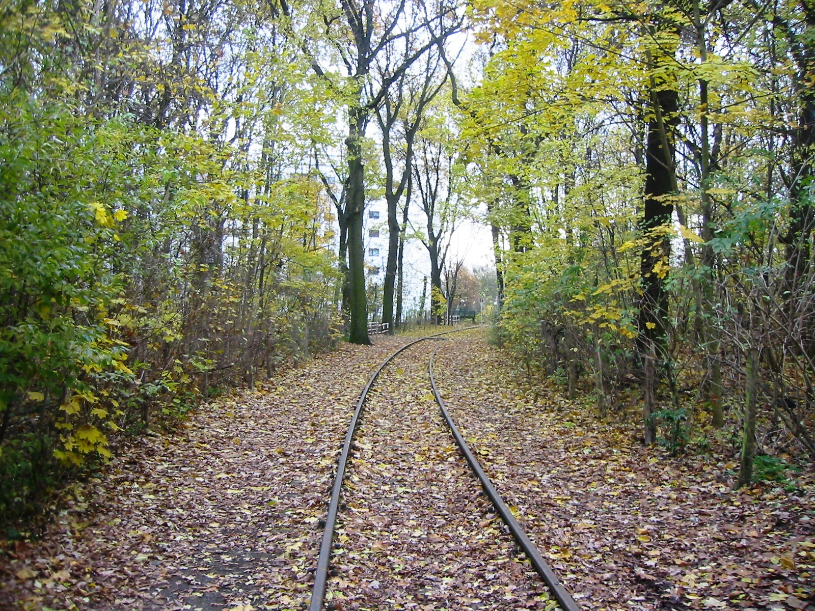
A disused railway track covered in fallen autumn leaves, winding into a forest area with tall trees and glimpses of a residential building in the distance.
A former railway line winding through the autumn woods of the Vogelschutzgebiet am Wildmeisterdamm.

Vogelschutzgebiet am Wildmeisterdamm in Rudow history and protected-area timeline

The origins of the woodland reach back to 1872, when Wildmeister Hugo Luther, acting on commission from Kaiser Wilhelm I, planted the area as a Wildremise, or game enclosure, used in annual court hunts. In those early decades, hunts could reportedly yield up to a thousand hares and nine hundred partridges. Wilhelm I later honored Luther by appointing him royal Wildmeister, and the former Buckower Chaussee was posthumously renamed Wildmeisterdamm in 1939 in his memory.

Through the 1920s and 1930s, the site's role as a hunting ground declined as surrounding development reduced local wildlife populations. By 1945, hunting was banned across Berlin, ending that phase of the site's history. In parallel, Wilhelm Schmidt, later the director of the Neukölln Heimatmuseum, had been advocating since 1929 to formally recognize the area as a bird sanctuary; this designation was achieved in 1934. Formal landscape protection status was added on 8 March 1952 by Berlin's Police President Johannes Stumm.

The mid-20th century brought significant physical disruption. The construction of the Berlin Wall forced the relocation of the Neukölln-Mittenwalder Eisenbahn rail line further west into the sanctuary, requiring extensive tree felling. Additional impact followed through the construction of the Sollmannweg, the Friedrich-Kayßler-Weg, and later works related to U-Bahn Line 7. When the Gropiusstadt housing development expanded around the area, the woodland was integrated into a planned green framework, and in 1987 the landscape planners Müller, Knippschild, and Wehberg reshaped the site into a designed landscape park. The forest patch was fenced to reduce soil compaction from footpaths and encourage regrowth of understory and ground flora. Since 2006, the protected landscape has been part of the Gartenkulturpfad Neukölln.

Vogelschutzgebiet am Wildmeisterdamm in Rudow landscape and geographic character

The landscape is that of a small urban broadleaf woodland enclosed within the planned residential environment of the Gropiusstadt district. The canopy is dominated by native deciduous species such as birch, oak, linden, chestnut, and poplar, with elm and wild cherry adding additional vertical and seasonal diversity. Beneath the tree cover, the ground supports a developing layer of shrubs, herbs, and natural undergrowth, an outcome that the 1987 redesign deliberately encouraged through fencing and controlled access.

Although the protected area is only a few hectares in footprint, it reads as a distinctly wooded pocket within the surrounding built fabric of southern Berlin. A relic of the former Neukölln-Mittenwalder Eisenbahn corridor crosses through the woodland, now preserved as a quiet linear trace through the trees rather than an active transport route, lending the site a subtle layering of industrial and natural landscape history.

Vogelschutzgebiet am Wildmeisterdamm in Rudow ecosystems, habitats, and plant life

Ecologically, the site functions as a small broadleaf forest patch within a dense urban matrix, offering a habitat mosaic of mature trees, developing undergrowth, and sheltered interior conditions. The mix of birch, oak, linden, chestnut, poplar, elm, and wild cherry creates a structurally varied canopy that supports insect populations and, in turn, a resident community of breeding birds.

Because the woodland is fenced to limit heavy foot traffic, the interior conditions favor regeneration of natural ground flora and understory species. This combination of canopy diversity and protected ground layer distinguishes the site from typical inner-city parks: it reads as a working woodland fragment rather than an ornamental green space, and that working character is central to its ecological value within the Neukölln district.

Vogelschutzgebiet am Wildmeisterdamm in Rudow wildlife and species highlights

The site's most persistent ecological identity is its birdlife. Wilhem Schmidt's historical surveys documented 46 bird species associated with the area, and roughly 26 of those species still breed in the woodland today. This continuity over decades, despite heavy surrounding urbanization, gives the site an unusual significance as an inner-city breeding bird refuge.

The combination of mature deciduous trees, dense understory, and a protected, lightly disturbed interior provides nesting and feeding habitat typical of small urban forest patches in central Europe. While detailed species lists are not the focus here, the woodland's continued role as active breeding habitat for more than two dozen species underlines why it has retained protected status for so long.

Vogelschutzgebiet am Wildmeisterdamm in Rudow conservation status and protection priorities

Conservation significance at Vogelschutzgebiet am Wildmeisterdamm comes from its longevity and its persistence within a heavily urbanized setting. The site received bird sanctuary designation in 1934 and landscape protection status in 1952, giving it more than seven decades of continuous formal protection. It is classified at IUCN Category V, reflecting its role as a protected landscape rather than a strict nature reserve, and is recorded in the World Database on Protected Areas.

Its real conservation value lies in function: a small, structurally diverse broadleaf woodland that supports a breeding bird community within one of Berlin's densest residential districts. The 1987 redesign, which fenced the woodland interior to reduce soil compaction and encourage natural understory development, was an early practical example of using landscape planning tools to reinforce ecological value rather than displace it. Its integration into the Gartenkulturpfad Neukölln since 2006 has also extended that conservation framing into cultural heritage programming.

Vogelschutzgebiet am Wildmeisterdamm in Rudow cultural meaning and human context

The woodland carries deep historical resonance as a former royal hunting reserve, planted in 1872 under Kaiser Wilhelm I and maintained by royal Wildmeister Hugo Luther. The naming of Wildmeisterdamm in 1939, posthumously honoring Luther, embedded this hunting-era heritage directly into Berlin's street identity and kept the site's origins visible in everyday civic language.

In the 20th century the site also became entangled with broader episodes of Berlin's history: the disruptions of the Wall era, the construction of the Gropiusstadt housing development, and the deliberate decision to weave the woodland into that new neighborhood as a shared green asset. Today, as part of the Gartenkulturpfad Neukölln, the area is presented not only as a nature site but as a piece of district-level garden and landscape heritage.

Top sights and standout views in Vogelschutzgebiet am Wildmeisterdamm in Rudow

Key highlights include the site's unusually long history of formal protection, stretching from 1934 as a bird sanctuary to 1952 as a landscape protection area; its origin as a royal game reserve planted under Kaiser Wilhelm I in 1872; its persistence as a breeding habitat for around 26 bird species despite being surrounded by dense urban development; and its 1987 transformation into a designed landscape park by Müller, Knippschild, and Wehberg, which deliberately used fencing to encourage natural understory regrowth.

Best time to visit Vogelschutzgebiet am Wildmeisterdamm in Rudow

Because the site is small and primarily valued for its woodland character and birdlife, it functions as a year-round quiet green stop within Berlin's urban fabric. Spring and early summer tend to be the most rewarding periods for visitors interested in songbirds and fresh understory growth, while autumn brings strong canopy color from the site's mix of birch, oak, linden, chestnut, and other deciduous species. Winter visits offer a more skeletal view of the woodland structure and the visible trace of the former Neukölln-Mittenwalder Eisenbahn corridor running through the trees.

Monthly climate preview

Long term temperature ranges and monthly precipitation cycles across the representative coordinate

Vogelschutzgebiet am Wildmeisterdamm in Rudow Climate Normals and Annual Weather Patterns

Representative coordinate measurements reveal annual temperature variations from sub zero winter minimums to warm summer maximums alongside steady daily precipitation rates. Examining the complete monthly climate profile provides deeper context for long term meteorological patterns across the protected terrain.
Annual mean9 °C
-1 °C20 °C
Jan-1°
Feb
Mar
Apr
May14°
Jun18°
Jul20°
Aug20°
Sep15°
Oct
Nov
Dec
Warmest month
July

20.3 °C

Coolest month
January

-0.9 °C

Wettest month
July

2.4 mm/day

Driest month
April

1.1 mm/day

Park location guide

Geography guide, regional context, and park location map for Vogelschutzgebiet am Wildmeisterdamm in Rudow

Vogelschutzgebiet am Wildmeisterdamm in Rudow park geography, regions, and map view in Germany

Understand where Vogelschutzgebiet am Wildmeisterdamm in Rudow sits in Germany through a broader geographic reading of the surrounding landscape, nearby location context, and its mapped position within the national park landscape.

How Vogelschutzgebiet am Wildmeisterdamm in Rudow fits into Germany

Germany is a federal republic in Western and Central Europe with a population of over 83 million across sixteen constituent states. It is Europe's largest economy by nominal GDP and a major global exporter and importer. The capital is Berlin, and the country borders Denmark, Poland, Czech Republic, Austria, Switzerland, France, Luxembourg, Belgium, and the Netherlands.

Wider geography shaping Vogelschutzgebiet am Wildmeisterdamm in Rudow in Germany

Germany is located in Western and Central Europe, spanning 357,022 km². It borders Denmark to the north, Poland and the Czech Republic to the east, Austria and Switzerland to the south, and France, Luxembourg, Belgium, and the Netherlands to the west. The country has coastlines on the Baltic Sea and North Sea to the north, with the Alps located in the southern region.

Map view of Vogelschutzgebiet am Wildmeisterdamm in Rudow

Use this park location map to pinpoint Vogelschutzgebiet am Wildmeisterdamm in Rudow in Germany, understand its exact geographic position, and read its mapped placement within the surrounding landscape more clearly.

Pigeon | © OpenStreetMap contributors

Location context for Vogelschutzgebiet am Wildmeisterdamm in Rudow

Berlin

Examine the urban woodland canopy, broadleaf habitats, and protected landscape character

Visual Exploration of Vogelschutzgebiet am Wildmeisterdamm in Rudow Photos and Scenery

Visual documentation reveals the dense broadleaf canopy and protected woodland terrain defining Vogelschutzgebiet am Wildmeisterdamm in Rudow. Detailed photography captures the urban bird sanctuary environment, canopy structure, and historic reserve features.

A disused railway track covered in fallen autumn leaves, winding into a forest area with tall trees and glimpses of a residential building in the distance.

A dirt path covered in fallen leaves winding into a dense, deciduous forest.

Park atlas

Compare nearby urban woodlands and regional protected landscapes across southern Berlin.

Parks Near Vogelschutzgebiet am Wildmeisterdamm in Rudow and Surrounding Protected Areas

Browse other parks and protected areas near Vogelschutzgebiet am Wildmeisterdamm in Rudow to evaluate surrounding green spaces and urban woodland habitats. Expanding the geographic scope reveals connected regional conservation terrain and related landscape reserves throughout the surrounding region.
Nature reserveBerlin
About 3 km away#1 closest

Northeast

Wasserwerk Johannisthal Nature Reserve: Mapping Berlin's Industrial and Hydrological Landscape

A protected urban groundwater zone in Treptow-Köpenick.

Explore the unique geography of Wasserwerk Johannisthal, a nature reserve in Berlin that balances industrial heritage with modern environmental management. This thirty-five-hectare site offers insights into urban protected areas, showing how historic water infrastructure is now secured for groundwater monitoring and remediation, set against the backdrop of the city's complex transport and green-space network.

Area
0.35 km²
Established
2007
IUCN
IV
Relief
Lowland
A watercolor painting showing a soft, abstract landscape with rolling hills, a central body of water, and a tree-lined shoreline.
Nature reserveBerlin
About 9.1 km away#2 closest

East

Krumme Lake Nature Reserve: Geographic Overview and Protected Wetland Boundaries in Berlin

A preserved mosaic of alder swamp forest and Dahme floodplain habitat

Krumme Lake preserves a dense network of wetland habitats within the pine-dominated forests of Berlin's Treptow-Köpenick borough. This protected nature reserve integrates groundwater-influenced ecosystems and riparian forest remnants, providing a sanctuary for diverse amphibians and invertebrates that have become increasingly rare in surrounding urbanized landscapes.

Area
0.452 km²
Established
2004
IUCN
IV
Relief
Lowland
A pale, minimalist watercolor painting depicting an open field with a winding stream, scattered trees, and distant rolling hills on a white background.
Nature reserveBerlin
About 9.2 km away#3 closest

Northeast

Biesenhorster Sand Nature Reserve: Protected Glacial Landscape in Berlin

Urban nature reserve featuring dry grassland and rare species habitats.

Located in eastern Berlin, Biesenhorster Sand preserves a significant glacial outwash plain that supports an extraordinary concentration of rare species. This nature reserve serves as a vital ecological corridor, protecting a mosaic of dry grassland and open sand terrain that contrasts with the surrounding urban fabric of Germany's capital.

Area
0.429 km²
Established
2021
Relief
Lowland
Scope
Terrestrial
A watercolor painting showing a soft, stylized landscape with open fields, a line of green trees, and distant hills under a light sky.
Protected landscapeBrandenburg
About 10 km away#4 closest

Southwest

Landschaftsschutzgebiet Diedersdorfer Heide und Großbeerener Graben Geography and Map Overview

A critical protected area in Brandenburg's peri-urban landscape mosaic.

Analyze the complex topography of Landschaftsschutzgebiet Diedersdorfer Heide und Großbeerener Graben, a large-scale protected zone south of Berlin. This atlas record provides detailed insight into the area's pine-dominated forest structure, wetland meadows, and the historic hydrological systems that define its contemporary habitat patterns and ecological reach.

Area
55 km²
Established
1998
Relief
Lowland
Scope
Terrestrial
A soft watercolor illustration of a lowland wetland landscape with a small pool of water, grasses, and scattered trees under a light sky.
Nature reserveBrandenburg
About 10 km away#5 closest

Southeast

Flutgrabenaue Waltersdorf Nature Reserve: Protected Wetland Geography and Regional Atlas

A significant floodplain sanctuary in the Brandenburg lowlands.

Flutgrabenaue Waltersdorf represents an ecologically rich lowland floodplain featuring sinuous watercourses, alder swamps, and traditional meadow habitats. Located south of Berlin, this reserve provides a vital geographic contrast to the urbanized infrastructure of the Brandenburg region. Use this overview to study the boundary, terrain characteristics, and regional importance of this protected marshland landscape.

Area
2.88 km²
Established
1998
IUCN
IV
Relief
Lowland
Nature reserveBerlin
About 11 km away#6 closest

East

Teufelsseemoor Köpenick: Protected Kettle Bog Geography and Urban Wetland Atlas

Glacial landscape and conservation zone in Berlin, Germany

Teufelsseemoor Köpenick is a key nature reserve in Berlin that showcases the transition from post-glacial kettle hole to a thriving peatland and swamp forest. This protected area stands out for its ecological gradient and serves as a model of urban wilderness conservation. The site is defined by the contrast between its still waters and the surrounding moraine ridges of the Müggelberge.

Area
0.065 km²
Established
2016
IUCN
IV
Watercolor painting of a rolling landscape with green grass, bushes, and soft-colored hills in the background.
Protected landscapeBerlin
About 12 km away#7 closest

Northeast

Kaulsdorfer Seen: A Protected Landscape in Berlin with Glacial and Industrial History

Exploring the groundwater protection zones and post-mining lakes of eastern Berlin

The Kaulsdorfer Seen area represents a distinct protected landscape located in Berlin. It showcases the transition between ice-age glacial regions, featuring two prominent lakes that evolved from sand and gravel pits into a mature ecosystem of willow thickets, woodland, and reeds. This site functions as an important drinking-water protection zone, offering a structured look at the complex interplay between urban development and natural resource conservation.

Area
0.937 km²
Water
Major water bodies
A watercolor painting showing a soft green marshy landscape with low hills in the background and a winding stream in the foreground.
Nature reserveBerlin
About 15 km away#8 closest

Northwest

Hundekehlefenn Nature Reserve: Geography and Protected Wetland Landscapes in Berlin

Glacial meltwater channel and moorland in Grunewald

Hundekehlefenn represents one of the last surviving pieces of original Berlin vegetation, preserved as a nature reserve within the city limits. This compact protected area showcases a glacial meltwater channel geography, featuring marshy depressions, mesotrophic bog remnants, and alder swamp forests. It serves as an essential ecological link within the Grunewaldseenkette lake chain, providing a window into the natural terrain history of the region.

Area
0.1 km²
Established
1987
Relief
Lowland
Climate
Temperate

Common questions about visiting, size, designation, and location context for Vogelschutzgebiet am Wildmeisterdamm in Rudow

Vogelschutzgebiet am Wildmeisterdamm in Rudow FAQs for park facts, access, geography, and protected area context

Find quick answers about Vogelschutzgebiet am Wildmeisterdamm in Rudow, including protected-area facts, park geography, trail and visitor context, and how the park fits into its surrounding country and regional landscape.
MoriAtlas Explorer

Continue Your Protected Areas Search Across the Global Atlas

Deepen your exploration by continuing the structured search for national parks and protected areas worldwide. Utilize the comprehensive filtering capabilities to compare different conservation landscapes and refine your understanding of global park geography. Discover more about the distribution and characteristics of protected natural areas.

Global natural geography