
Mori Atlas logo
Protected areaVogelschutzgebiet Fiener Bruch

Explore the extensive lowland mosaic and vital avian habitats of this cross-border conservation landscape.

Vogelschutzgebiet Fiener Bruch: Mapped Protected Area and Glacial Wetland Geography in Brandenburg

Vogelschutzgebiet Fiener Bruch represents a major ecological complex spanning over ten thousand hectares across the Brandenburg and Saxony-Anhalt border region. This glacial valley, shaped by ancient meltwater corridors, serves as a vital refuge for threatened grassland birds and migratory species. The area features a unique mosaic of drained alder carr, wet meadows, and open agricultural uplands, providing a study in the intersection of human-managed land use and critical biodiversity protection.

wetlandbird sanctuarygreat bustardNatura 2000Special Protection Areawet meadows
A flat vector illustration of a landscape featuring a waterfall cascading down cliffs, green trees, bare trees, and grassy foreground under a pastel sky.

Vogelschutzgebiet Fiener Bruch

Protected area

Park overview

Structured park overview, official facts, and landscape profile for Vogelschutzgebiet Fiener Bruch

Vogelschutzgebiet Fiener Bruch park facts, protected area profile, and essential visitor context

Review the core facts for Vogelschutzgebiet Fiener Bruch, including designation, size, terrain, visitor scale, habitats, and operating context in one park-focused overview.

About Vogelschutzgebiet Fiener Bruch

Vogelschutzgebiet Fiener Bruch is a large European bird sanctuary covering the Fiener Bruch lowland valley and adjacent upland areas in eastern Germany. It is administered as a Natura 2000 Special Protection Area, split between the federal states of Brandenburg and Saxony-Anhalt and therefore subject to two separate site designations. The combined protected area spans roughly 10,000 hectares, making it one of the more significant inland bird sanctuaries in the region.

The Fiener Bruch itself is a broad glacial valley, the northwestern extension of the Glogau-Baruth Urstromtal, the long ice-age meltwater corridor that cuts across eastern Germany. Historically, the valley supported an alder carr forest, a wet woodland typical of incompletely drained lowlands. Centuries of clearing, drainage, and agricultural conversion transformed this woodland into a landscape of species-rich wet meadows interlaced with drainage ditches, and it is this human-shaped mosaic that gives the modern sanctuary its ecological character.

The sanctuary is recognized primarily for its importance to the great bustard, one of the heaviest flying birds in Europe and a species whose German populations collapsed during the late twentieth century. The Fiener Bruch hosts one of only three remaining breeding populations in Germany, alongside the Belziger Landschaftswiesen further south in the Baruth Urstromtal and the Havelländisches Luch north of the city of Brandenburg an der Havel. Natural movements between these three populations link them into a single metapopulation, and the Fiener Bruch population has recovered from around ten individuals in the 1990s to several dozen in the 2010s thanks to coordinated protection measures.

Beyond the bustard, the area is ecologically significant for an exceptionally diverse community of breeding and migrating birds. The mosaic of wet meadows, reed fringes, drainage ditches, and adjacent farmland supports waterbirds such as mute swan, greylag goose, mallard, tufted duck, and little grebe, as well as herons, white stork, osprey, and a suite of raptors including hen harrier, marsh harrier, red and black kite, and hobby. Waders, ground-nesting rails such as corncrake and spotted crake, and specialized open-country passerines including bluethroat, barred warbler, woodlark, and ortolan also breed here, while the valley functions as a stopover site for many additional species during migration.

Management of the sanctuary is closely tied to its conservation function. After bustard numbers had collapsed to the brink of local extinction, a structured protection program was developed that combines habitat restoration, predator control, compensation payments to cooperating farmers, captive rearing and release of chicks rescued from threatened nests, and public outreach coordinated from the Königsroder Hof information center near Tucheim. These efforts, alongside the legal designation of the site as part of the Natura 2000 network, define the sanctuary both as a refuge for threatened wildlife and as a working landscape shaped by ongoing intervention.

Quick facts and research context for Vogelschutzgebiet Fiener Bruch

Vogelschutzgebiet Fiener Bruch is a two-part European bird sanctuary stretching across the federal states of Brandenburg and Saxony-Anhalt in eastern Germany, centered on the lowland Fiener Bruch wetland valley. With a combined area of about 10,000 hectares, it sits within the Natura 2000 network as a Special Protection Area for wild birds and is administered separately under two federal site codes.

Geologically, the Fiener Bruch represents the northwesternmost end of the Glogau-Baruth glacial Urstromtal, a broad ice-age meltwater valley. The original alder swamp forest was historically cleared and drained, giving rise to the species-rich wet grassland that defines the area today. Conservation significance rests on its status as one of only three remaining breeding sites for the great bustard in Germany, alongside the Belziger Landschaftswiesen and the Havelländisches Luch.

Protection and recognition

Examine the designated protection history and terrestrial management scope.

Vogelschutzgebiet Fiener Bruch Protection Status and Designation Records

Vogelschutzgebiet Fiener Bruch maintains a documented terrestrial protection status established in 1990 without transboundary borders. Structured records outline the formal designation history and available recognition details for this protected area.

Protection details

Protection scope
Terrestrial
Designated year
1990
Transboundary protection
No
Park context

Deeper park guide and search-rich context for Vogelschutzgebiet Fiener Bruch

Vogelschutzgebiet Fiener Bruch history, landscape, wildlife, and travel context

Explore Vogelschutzgebiet Fiener Bruch through its history, landscape character, ecosystems, wildlife, conservation priorities, cultural context, and seasonal travel timing in a structured park guide built for atlas discovery and search intent.

Why Vogelschutzgebiet Fiener Bruch stands out

The Vogelschutzgebiet Fiener Bruch is best known as one of the last refuges for the great bustard in Germany, hosting one of only three surviving breeding populations of this critically endangered steppe bird. The area's combination of extensive wet meadows and open arable uplands creates the mix of breeding habitat and winter foraging grounds that bustards depend on, and decades of targeted conservation have slowly rebuilt the local population from near extinction. Equally distinctive is the sanctuary's setting within the Fiener Bruch, a glacial valley wetland whose drained alder carr landscape has been transformed into one of the most species-rich wet-grassland complexes in eastern Germany. The protected area's significance extends well beyond bustards, providing breeding and stopover habitat for cranes, white storks, harriers, waders, and numerous other species characteristic of large Central European lowland wetland systems.
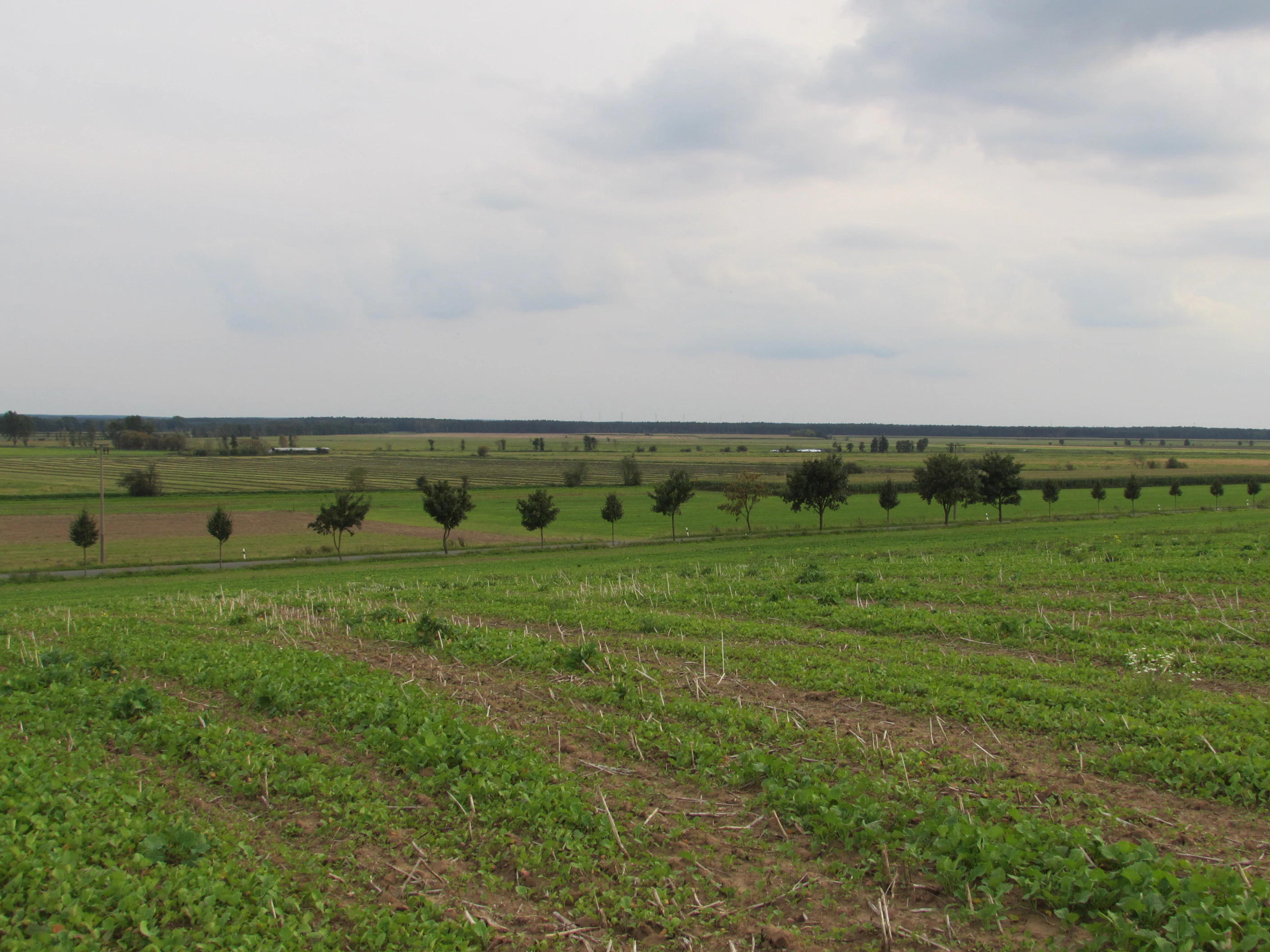
A wide shot of green agricultural fields with rows of crops in the foreground, a horizontal line of trees in the middle distance, and a cloudy grey sky.
View of the Fiener Bruch landscape showing agricultural fields and a tree line under an overcast sky.

Vogelschutzgebiet Fiener Bruch history and protected-area timeline

The ecological history of Vogelschutzgebiet Fiener Bruch is closely tied to centuries of land-use change in the Fiener Bruch valley. Originally a wet alder carr wetland shaped by glacial meltwater processes, the area was progressively cleared, drained, and converted into agricultural land, yielding the extensive species-rich wet meadows crossed by drainage channels that characterize the landscape today. This long transformation created the open wet-grassland conditions that later proved valuable for bird conservation, but it also reduced and fragmented the habitats on which many species depended.

The modern protection history began in 1979, when a dedicated Großtrappenschongebiet (great bustard protection area) called Karow was established in what was then the Bezirk Magdeburg. Covering roughly 5,800 hectares, it marked the first large-scale effort to safeguard German bustard habitat in this valley. After German reunification, the area was integrated into the European Natura 2000 network during the 1990s, becoming one of the early inland Special Protection Areas under the EU Birds Directive. Within the Saxony-Anhalt portion of the sanctuary, a 143-hectare nature reserve called Naturschutzgebiet Fiener Bruch was formally designated in 1997, adding a stricter national layer of protection on top of the European SPA designation.

In Brandenburg, the SPA boundaries were drawn more broadly than in Saxony-Anhalt, encompassing not only the Fiener Bruch wetlands but also the northern and southern agricultural uplands of the Karower Platte and Fläming edges. These uplands are used by bustards as wintering grounds, and their inclusion in the SPA reflected an understanding that the species requires a mosaic of seasonal habitats across the year. In Saxony-Anhalt, comparable wintering areas were surveyed but ultimately remained outside formal protection, leaving the cross-border coordination of bustard management as an ongoing challenge.

Conservation history since the 1990s has been shaped strongly by the work of the Förderverein Großtrappenschutz, a nonprofit association headquartered at the Königsroder Hof observation and information center near Tucheim. The association coordinates predator control, habitat restoration, nest rescue and captive rearing of chicks, and a compensation scheme for cooperating farmers, and its efforts have been credited with the recovery of the local bustard population from a low point of roughly ten individuals in the 1990s to around sixty to seventy in the mid-2010s.

Vogelschutzgebiet Fiener Bruch landscape and geographic character

The Fiener Bruch is a broad, flat lowland valley formed during the Pleistocene by glacial meltwater. It represents the northwesternmost extension of the Glogau-Baruth Urstromtal, the long ice-age meltwater corridor that traverses eastern Germany from the Polish border region to the Elbe. The valley floor is largely level, dissected by a network of drainage ditches that cross otherwise continuous tracts of wet grassland and meadow.

In its pre-human state, the valley supported extensive alder carr wetlands, with wet woodland tolerant of periodic flooding dominating the poorly drained soils. Centuries of clearing, drainage, and conversion to agriculture replaced this woodland character with the open, wet meadowland that defines the modern landscape. Today the valley floor is a mosaic of damp meadows, marshy patches, channels, and reedy margins, while the surrounding uplands of the Karower Platte and the western Fläming provide drier, arable terrain that grades gently into the wetland basin.

The two federal portions of the sanctuary differ in their immediate setting. The Brandenburg portion lies in Landkreis Potsdam-Mittelmark and the city of Brandenburg an der Havel, encompassing parts of Ziesar, Rosenau, Wusterwitz, and Wenzlow, while the Saxony-Anhalt portion occupies parts of Landkreis Jerichower Land around the towns of Genthin and Jerichow. Together they form a continuous ecological landscape rather than two isolated fragments, with the state boundary running through the wetland valley itself.
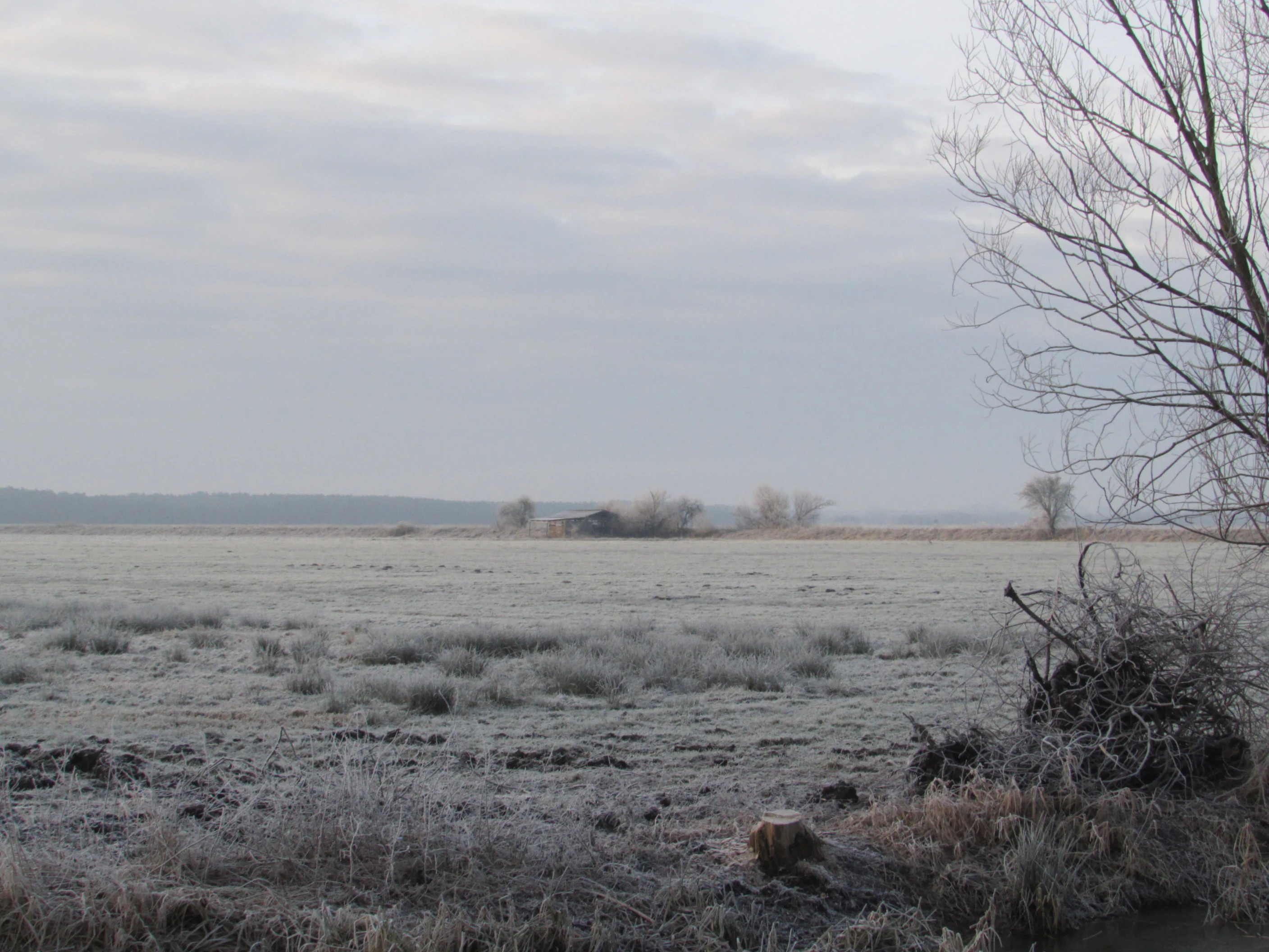
A wide, flat landscape covered in frost with bare shrubs and trees in the foreground and a distant tree line under a gray, cloudy sky.
Frost-covered fields and bare trees within the Fiener Bruch bird sanctuary under an overcast sky.

Vogelschutzgebiet Fiener Bruch ecosystems, habitats, and plant life

The ecological identity of Vogelschutzgebiet Fiener Bruch is defined by the interface between open wet grassland and adjacent agricultural uplands, a combination that has become exceptionally rare in modern central Europe. The valley floor supports species-rich meadows maintained in a wet, open state by historical drainage works and ongoing management, while the surrounding uplands retain an open arable character that provides seasonal foraging habitat for ground-nesting and flocking birds.

Within the wet meadowland, drainage ditches, reedy margins, and shallow flooded patches create a fine-grained habitat mosaic. This mosaic supports amphibians, aquatic invertebrates, and small mammals, while also providing nest sites, feeding areas, and cover for a wide range of bird species. Patches of reed, scrub, and isolated trees add structural diversity along ditch lines and field edges, supporting woodland-edge bird species alongside the more typical wetland and open-country fauna.

The broader ecological value of the area lies in its continuity as a low-disturbance, large-scale open landscape at a time when much of the surrounding region has been intensified, fragmented, or built over. By maintaining an unbroken mosaic of meadows, channels, and open uplands, the sanctuary preserves ecological processes and habitat connectivity that smaller, isolated protected areas cannot replicate. This landscape-scale integrity is also what allows the area to function as a stepping stone and stopover site for migratory species moving through the larger Glogau-Baruth Urstromtal corridor.

Vogelschutzgebiet Fiener Bruch wildlife and species highlights

The wildlife significance of Vogelschutzgebiet Fiener Bruch is dominated by its bird fauna, particularly the great bustard, for which the area is one of only three breeding strongholds in Germany. The local bustard population declined to roughly ten individuals in the 1990s, raising fears of imminent local extinction, but has since recovered to around sixty to seventy individuals through intensive protection measures. The valley's combination of open meadow breeding habitat and open upland wintering areas is uniquely suited to the species' annual cycle.

Alongside bustards, the sanctuary supports a rich community of breeding waterbirds and waders, including mute swan, greylag goose, mallard, tufted duck, little grebe, grey heron, white stork, water rail, corncrake, spotted crake, moorhen, lapwing, little ringed plover, curlew, and snipe. The open meadows and adjacent fields also host a notable raptor community, with osprey, honey buzzard, hen harrier, marsh harrier, red kite, black kite, and hobby all recorded as breeding species during surveys in the late 1990s and early 2000s.

In addition to the large and conspicuous species, the area is important for a range of smaller and more specialized open-country and wetland birds. Lesser spotted owl, kingfisher, hoopoe, black woodpecker, red-backed shrike, great grey shrike, woodlark, barred warbler, bluethroat, short-eared owl, grey partridge, and ortolan have all been recorded as breeding species, while many additional species use the valley as a stopover and resting site during migration. Crane flocks regularly pass through and feed in the sanctuary, reinforcing its wider significance as part of the central European migratory bird network.

Vogelschutzgebiet Fiener Bruch conservation status and protection priorities

The Vogelschutzgebiet Fiener Bruch holds conservation significance at multiple levels, from local species recovery to European network status. As a Special Protection Area under the EU Birds Directive, it forms part of the Natura 2000 network and contributes to the protection of migratory and threatened bird species at a continental scale. At a national level, the Saxony-Anhalt portion contains the smaller but strictly protected Naturschutzgebiet Fiener Bruch, adding a higher-tier national designation on top of the European SPA status.

Bustard conservation is the central focus of active management, coordinated largely by the Förderverein Großtrappenschutz from the Königsroder Hof information center near Tucheim. This work combines habitat restoration, including the re-wetting and re-opening of former grassland, with an intensive predator control program run by local hunters using traps and firearms. Roughly nineteen hectares of grassland have been enclosed by a predator-proof fence, within which nearly all naturally hatched bustard chicks have successfully fledged and outside of which natural breeding success has been very low.

Agricultural cooperation forms a further pillar of the conservation strategy. Farmers receive compensation payments for adapting their land use to bustard requirements, including the establishment of special food strips, the retention of uncut grass strips, the abandonment of fertilization, and the temporary withdrawal of parts of their fields from production. Threatened nests are collected and artificially incubated, and the hatched chicks are reared and released into the protected area, creating an intensive, hands-on program that has rebuilt the local population.

The broader conservation value of the area lies in maintaining a large, open, low-disturbance landscape at a time when intensified agriculture and energy infrastructure development are putting similar habitats across central Europe under pressure. Rapid expansion of wind energy in particular is identified as a major emerging threat, both within the wintering grounds of the bustard and along the migratory corridors that connect the three remaining German breeding populations. The Fiener Bruch thus stands not only as a local recovery site but as a critical node in the national and European network of bustard strongholds.

Vogelschutzgebiet Fiener Bruch cultural meaning and human context

The cultural dimension of the Vogelschutzgebiet Fiener Bruch is closely tied to the long agricultural history of the Fiener Bruch valley. The landscape that the sanctuary protects is itself a cultural artifact, the result of centuries of woodland clearance, drainage, and conversion to meadow and arable use by rural communities. The drainage ditches, field patterns, and settlement locations visible today reflect this layered history of human intervention in a floodplain that was originally forested wetland.

Within the protected area, the Königsroder Hof near Tucheim functions as a small cultural and educational hub. Operated by the Förderverein Großtrappenschutz, the site combines a public observation tower with an information center that hosts regular events focused on bustard conservation. This outreach work links the site's ecological mission with regional identity, framing bustard protection as part of the broader heritage of the Fiener Bruch landscape rather than as a purely technical conservation project.

The cross-border character of the sanctuary, spanning Brandenburg and Saxony-Anhalt, also gives it a modest but real cultural significance as a place where two modern German federal states share responsibility for a single ecological landscape. The differing approaches to wintering-ground protection between the two sides reflect historical differences in land use and conservation tradition, and the ongoing cooperation needed to manage bustard movements across the state line has become a quiet but important element of regional conservation culture.

Top sights and standout views in Vogelschutzgebiet Fiener Bruch

Among the Vogelschutzgebiet Fiener Bruch's most important qualities is its role as one of only three remaining great bustard breeding areas in Germany, a status that places it at the heart of national efforts to recover the species. Equally distinctive is the sanctuary's landscape-scale continuity, with over ten thousand hectares of wet meadows, drainage channels, and open upland farmland maintained as a single ecological unit across two federal states.

The protected area also stands out for the intensity and integration of its bustard conservation program, which combines predator-proof fencing, predator control, nest rescue and captive rearing, habitat restoration, and a structured compensation scheme for cooperating farmers. The cross-border Natura 2000 designation, the embedded Naturschutzgebiet Fiener Bruch, and the public information center at the Königsroder Hof together make the sanctuary a notable example of integrated European, national, and local conservation action in a working agricultural landscape.

Best time to visit Vogelschutzgebiet Fiener Bruch

The Vogelschutzgebiet Fiener Bruch offers a markedly different character across the seasons, and the timing of a visit shapes what kind of birdlife and atmosphere a visitor is likely to encounter. Spring is the most dynamic period for breeding birds: arriving migrants settle across the meadows and uplands, displaying males of the great bustard become visible on traditional lekking sites, and the mix of breeding waterbirds, waders, and raptors is at its richest. This is also when the conservation work of the Förderverein Großtrappenschutz, including regular events at the Königsroder Hof information center, is most active.

Summer brings continued breeding activity and the highest density of fledglings across the wet meadows, while the surrounding upland arable fields provide additional feeding and shelter for family groups of bustards and other open-country species. The vegetation is at its tallest, giving the landscape a lush, green character in which the open mosaic of meadows and channels remains visible mainly from the observation tower and along accessible field tracks.

Autumn and winter shift the focus from breeding birds to migratory passage and wintering flocks. Cranes and other migrants stage in the valley, and wintering bustards gather on the open uplands of the Karower Platte and the Fläming edges, where they feed on agricultural stubbles. Winter visits offer colder, quieter conditions and a clearer view across the open landscape, with frost and, in some years, snow exposing the structure of ditches, meadow edges, and field patterns in a way that summer vegetation conceals.

Monthly climate preview

Long-term representative point measurements tracking monthly temperature and precipitation patterns

Vogelschutzgebiet Fiener Bruch Climate Normals and Annual Temperature Rhythm

Vogelschutzgebiet Fiener Bruch exhibits a measured annual temperature and precipitation rhythm across twelve recorded intervals at a representative coordinate. Examining the complete monthly climate normals reveals detailed long-term averages for average minimum and maximum temperatures alongside daily precipitation rates.
Annual mean9 °C
0 °C20 °C
Jan
Feb
Mar
Apr
May14°
Jun18°
Jul20°
Aug20°
Sep15°
Oct
Nov
Dec
Warmest month
July

19.9 °C

Coolest month
January

-0.4 °C

Wettest month
July

2.4 mm/day

Driest month
April

1.1 mm/day

Park location guide

Geography guide, regional context, and park location map for Vogelschutzgebiet Fiener Bruch

Vogelschutzgebiet Fiener Bruch park geography, regions, and map view in Germany

Understand where Vogelschutzgebiet Fiener Bruch sits in Germany through a broader geographic reading of the surrounding landscape, nearby location context, and its mapped position within the national park landscape.

How Vogelschutzgebiet Fiener Bruch fits into Germany

Germany is a federal republic in Western and Central Europe with a population of over 83 million across sixteen constituent states. It is Europe's largest economy by nominal GDP and a major global exporter and importer. The capital is Berlin, and the country borders Denmark, Poland, Czech Republic, Austria, Switzerland, France, Luxembourg, Belgium, and the Netherlands.

Wider geography shaping Vogelschutzgebiet Fiener Bruch in Germany

Germany is located in Western and Central Europe, spanning 357,022 km². It borders Denmark to the north, Poland and the Czech Republic to the east, Austria and Switzerland to the south, and France, Luxembourg, Belgium, and the Netherlands to the west. The country has coastlines on the Baltic Sea and North Sea to the north, with the Alps located in the southern region.

Map view of Vogelschutzgebiet Fiener Bruch

Use this park location map to pinpoint Vogelschutzgebiet Fiener Bruch in Germany, understand its exact geographic position, and read its mapped placement within the surrounding landscape more clearly.

Pigeon | © OpenStreetMap contributors

Location context for Vogelschutzgebiet Fiener Bruch

Brandenburg

Visual reference of wet meadow habitats and glacial valley terrain

Vogelschutzgebiet Fiener Bruch Photos, Landscapes, and Scenery

Visual records capture the expansive wet meadows, drainage channels, and open lowland habitats defining Vogelschutzgebiet Fiener Bruch. Photographic documentation reveals the protected terrain and conservation landscapes supporting rare breeding bird populations.

A wide shot of green agricultural fields with rows of crops in the foreground, a horizontal line of trees in the middle distance, and a cloudy grey sky.

A wide landscape shot of a green and brown grassy field. A single large white bird stands in the center middle distance. A long fence runs horizontally across the scene, separating the field from a line of leafless trees under a pale, overcast sky.

A wide, flat landscape covered in frost with bare shrubs and trees in the foreground and a distant tree line under a gray, cloudy sky.

Park atlas

Compare adjacent wetland valleys and regional conservation areas across eastern Germany

Parks Near Vogelschutzgebiet Fiener Bruch and Related Protected Landscapes

Browsing protected areas near Vogelschutzgebiet Fiener Bruch reveals connected lowland wetland valleys and regional bird sanctuaries. Comparing adjacent conservation landscapes provides broader context on Central European glacial valley ecosystems.
Nature reserveBrandenburg
About 29 km away#1 closest

East

Belziger Landschaftswiesen Nature Reserve: Protected Wetland Geography and Glacial Valley Mapping

Regional landscape profile, peatland ecology, and glacial valley terrain

Spanning over 7,000 hectares in the Baruther Urstromtal, the Belziger Landschaftswiesen serves as a vital nature reserve and lowland habitat in Brandenburg. This geography-focused profile traces the wetland's identity as a through-flow peatland, its role in hosting rare meadow birds, and the defining physical edges where the flat valley floor meets the high Fläming ridge.

Area
45 km²
Established
2005
Relief
Lowland
Climate
Temperate
A watercolor illustration showing a landscape with small clusters of trees and grassy ground under a soft, light-filled sky.
Nature reserveBrandenburg
About 32 km away#2 closest

East

Lehniner Mittelheide und Quellgebiet der Emster: Nature Reserve and Protected Landscape Atlas

Mapping Brandenburg inland heath and spring valley terrain

Examine the geographic layout of Lehniner Mittelheide und Quellgebiet der Emster, a nature reserve in the Brandenburg district of Potsdam-Mittelmark. This protected area connects dry sandy heathland with the aquatic corridors of the Emster headwaters and Mühlenteich pond, offering a clear example of glacial lowland landscape integration.

Area
6.4 km²
Established
1996
IUCN
IV
Relief
Lowland
Watercolor illustration of a rolling landscape with green hills, a winding stream, and coniferous trees on a white background.
Protected landscapeBrandenburg
About 34 km away#3 closest

Southeast

Naturpark Hoher Fläming: A Protected Landscape Discovery in Brandenburg, Germany

Mapping glacial ridges, historic churches, and rural meadow lowlands.

Naturpark Hoher Fläming encompasses a vast protected landscape in Brandenburg, characterized by mature forested uplands and flat glacial valleys. Gain insight into the park's geomorphology, including its rare dry valleys and well-preserved medieval cultural sites, providing a structured look at one of Germany's significant natural regions.

Area
827 km²
Established
1997
Relief
Upland
Climate
Temperate
Protected areaSaxony-Anhalt
About 34 km away#4 closest

North

Klietzer Heide: Protected Heathland and Glacial Moraine Landscapes in Saxony-Anhalt

An ecological atlas of sandy inland dunes and forest habitats

Klietzer Heide represents a crucial protected area in northern Saxony-Anhalt, showcasing a complex mosaic of open heather, shifting inland dunes, and mature pine forests. Shaped by Weichselian glaciation and decades of military land management, the site provides a vital sanctuary for rare insects and nesting birds, offering a clear contrast to the surrounding forested plains of the Schollener Land.

Area
25.79 km²
Established
2000
Watercolor painting of a lush, flat landscape with low green hills in the distance and wetland vegetation in the foreground.
Protected landscapeBrandenburg
About 35 km away#5 closest

Northeast

Landschaftsschutzgebiet Brandenburger Osthavelniederung: Protected Landscape and Regional Geography

Mapped Havel River floodplain and glacial moraine terrain in Brandenburg.

Covering over 9,000 hectares, this protected landscape serves as a prime example of the Brandenburg Havel region. The area integrates a network of canals, dikes, and backwater lakes with isolated moraine ridges, creating a diverse geographic mosaic of river-managed lowlands and forested glacial remnants.

Area
93.81 km²
Established
1998
Relief
Lowland
Climate
Temperate
Nature reserveBrandenburg
About 41 km away#6 closest

East

Naturschutzgebiet Krielower See: Protected Nature Reserve and Glacial Wetland Geography

Located in Brandenburg, this reserve protects a complex, silted-up lake basin and wetland network.

Naturschutzgebiet Krielower See protects a distinct glacial landscape near the Havel river. This 155-hectare nature reserve preserves a network of alder carr, reed beds, and wet meadows, providing an essential refuge for diverse species within the broader Havelland natural region. Explore the mapped topography and conservation context of this integral Brandenburg wetland habitat.

Area
1.55 km²
Established
2004
Relief
Lowland
Climate
Temperate
A soft watercolor illustration showing rolling green hills, a small stream winding through the foreground, and distant purple-toned peaks against a white background.
Nature reserveBrandenburg
About 43 km away#7 closest

East

Glindower Alpen: Protected Nature Reserve and Clay Mining Geography in Brandenburg

A striking post-industrial landscape and nature reserve

Glindower Alpen is a 120-hectare nature reserve near Werder, Germany, characterized by an atypical terrain of deep ravines and ridges resulting from historical clay mining. This protected area stands out as an island of mixed deciduous forests and dry grasslands amidst the broader flat geography of the Brandenburg region.

Area
1.19 km²
Established
1995
Relief
Upland
Climate
Temperate
A watercolor painting showing a panoramic view of a calm lake with grassy shorelines and small tree-covered islands under a pale sky.
Nature reserveBrandenburg
About 48 km away#8 closest

North

Gülper See Nature Reserve: Brandenburg Protected Wetland Geography and Landscape Map

Shallow glacial lake basins and floodplain ecology in the Westhavelland.

Gülper See is an ecologically significant nature reserve in Brandenburg, Germany, representing a rare, open lowland landscape defined by shallow glacial water, extensive reed belts, and seasonal wet meadows. As part of the Westhavelland, the site offers unique insight into the hydrological heritage of the Havel floodplain, serving as a primary sanctuary for migratory geese and common cranes within an exposed, forest-free terrain.

Area
6.6 km²
Established
1967
Relief
Lowland
Climate
Temperate

Common questions about visiting, size, designation, and location context for Vogelschutzgebiet Fiener Bruch

Vogelschutzgebiet Fiener Bruch FAQs for park facts, access, geography, and protected area context

Find quick answers about Vogelschutzgebiet Fiener Bruch, including protected-area facts, park geography, trail and visitor context, and how the park fits into its surrounding country and regional landscape.
MoriAtlas Explorer

Continue Your Protected Areas Search Across the Global Atlas

Deepen your exploration by continuing the structured search for national parks and protected areas worldwide. Utilize the comprehensive filtering capabilities to compare different conservation landscapes and refine your understanding of global park geography. Discover more about the distribution and characteristics of protected natural areas.

Global natural geography