Mori Atlas logo
Nature reserveBelziger Landschaftswiesen

Mapped terrain, wetland ecology, and glacial history within the Baruther Urstromtal landscape

Belziger Landschaftswiesen: A Protected Glacial Valley and Through-flow Peatland in Brandenburg

(Naturschutzgebiet Belziger Landschaftswiesen)

Belziger Landschaftswiesen represent a distinct lowland landscape in southwestern Brandenburg, situated entirely within the Baruther Urstromtal glacial meltwater valley. This nature reserve, characterized by rare through-flow peatlands and open meadow mosaics, provides essential habitat for meadow breeding birds and Germany's last remaining population of the great bustard. The area offers a profound geographic perspective on the interplay between Cistercian land reclamation, historical border regions, and preserved natural terrain.

wetlandmeadowpeatlandurstromtalgreat bustardbird sanctuary

Belziger Landschaftswiesen

Nature reserve

Park overview

Structured park overview, official facts, and landscape profile for Belziger Landschaftswiesen

Belziger Landschaftswiesen park facts, protected area profile, and essential visitor context

Review the core facts for Belziger Landschaftswiesen, including designation, size, terrain, visitor scale, habitats, and operating context in one park-focused overview.

About Belziger Landschaftswiesen

The Belziger Landschaftswiesen are a flat, boggy expanse of meadows in southwestern Brandenburg, stretching about three to five kilometers across the floor of the Baruther Urstromtal northeast of Bad Belzig. The landscape was carved roughly 21,000 years ago by meltwater from the Weichselian ice sheet, which deposited thick layers of sand and, where it pressed against the high Fläming slope, eroded banks up to sixty meters tall. After the ice retreated and the glacial river course shifted northward to the Berliner Urstromtal, the valley floor dried and later rewetted about 7,000 to 9,000 years ago, allowing extensive peat formation and the development of large alder, ash, oak, and hornbeam swamp forests that were later cleared to create today's farmland.

Today the area is a designated nature reserve within the Naturpark Hoher Fläming, managed jointly with the Vogelschutzwarte Baitz and surrounding municipalities of Bad Belzig, Brück, and Planebruch. The reserve is integrated into a larger Natura 2000 mosaic that links the Nuthe-Nieplitz lowlands, the Fiener Bruch, the middle Havel, and the Havelländisches Luch, allowing ecological processes, water regimes, and species movements to be coordinated across the entire glacial valley system. With continuous meadows, scattered inland dunes, near-natural streams, and a cold-influenced continental microclimate, it represents one of the most intact and ecologically productive examples of a Brandenburg Urstromtal landscape.

Quiet, treeless and largely settlement-free, the Belziger Landschaftswiesen offer an unusually open vista for central Germany, framed by the 200-meter Hagelberg and the high Fläming ridge to the southwest and by the dry Zauche outwash plain to the northeast. Industrial-era drainage has been partially reversed since 1991 through targeted water management coordinated with local farmers, and practical reserve work focuses on balancing the demands of meadow-breeding birds, rare plants, and extensive agriculture rather than on dramatic rewilding.

Quick facts and research context for Belziger Landschaftswiesen

Belziger Landschaftswiesen is a roughly 7,600-hectare lowland plain in the Baruther Urstromtal in southwestern Brandenburg, administered since 1 July 2005 as a nature reserve of about 4,435 hectares within the larger Naturpark Hoher Fläming.

The terrain lies between 40 and 44 meters above sea level, is crossed by more than 169 kilometers of ditches and streams such as the Plane, the Baitzer Bach and the Belziger Bach, and today consists of about 65 percent grassland, with only about 0.1 percent woodland remaining. It forms part of the European Special Protection Area (SPA) 'Unteres Rhinluch, Dreetzer See, Havelländisches Luch und Belziger Landschaftswiesen' within the Natura 2000 network.

Protection and recognition

Terrestrial protected area framework established in 2005

Belziger Landschaftswiesen Protection Status and Designated History

Documented protection status and designation history outline the management scope established for Belziger Landschaftswiesen since 2005. Terrestrial conservation parameters provide structured geographic context without additional international recognition sources.

Protection details

Protection scope
Terrestrial
Designated year
2005
Transboundary protection
No
Park context

Deeper park guide and search-rich context for Belziger Landschaftswiesen

Belziger Landschaftswiesen history, landscape, wildlife, and travel context

Explore Belziger Landschaftswiesen through its history, landscape character, ecosystems, wildlife, conservation priorities, cultural context, and seasonal travel timing in a structured park guide built for atlas discovery and search intent.

Why Belziger Landschaftswiesen stands out

The Belziger Landschaftswiesen are most renowned as one of Germany's last important refuges for the great bustard (Otis tarda), a heavy steppe bird that colonized the meadows from the east around 1800 and now survives here thanks to targeted conservation and contract-based farming. Protection of bustard breeding and feeding habitats shapes the reserve's entire management regime and gives the landscape much of its conservation identity. The area is equally notable for its rare Durchströmungsmoor, an unusual through-flow peatland threaded by near-natural lowland streams, and for the rich mosaic of moist and dry meadow types, sand-dry grasslands on inland dunes, and alder swamp fragments that have replaced the formerly dense alder-oak-ash forests. Together, these features make the meadows a textbook example of the Brandenburg Urstromtal landscape and a key node in a wider Havel, Nuthe-Nieplitz, and Fiener Bruch ecological network.
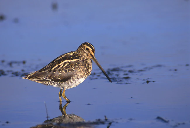
A common snipe with mottled brown and cream plumage and a long, straight bill standing in shallow, reflective water.
A common snipe standing in the shallow waters of the Belziger Landschaftswiesen.

Belziger Landschaftswiesen history and protected-area timeline

Archaeological finds show that the dry Fläming edges and the Zauche forests around the meadows have been inhabited since the late Bronze and early Iron Age, while the wetland itself was only gradually opened from the thirteenth century onward. In 1251 Count Baderich von Belzig donated the mill at Gömnigk on the River Plane, together with its associated waters reaching as far as Trebitz, to the Cistercian monastery of Lehnin, marking one of the earliest documented interventions in the marsh landscape and giving the monks a foothold in the originally Saxon territory around the Plane.

For centuries farmers from the Fläming villages made long, difficult hay-making expeditions into the meadows, since their dry slopes and periglacial dry valleys could not produce sufficient fodder; only at the beginning of the nineteenth century did improved water management make larger-scale hay production possible. The meadows also carried political weight: until 1815 they formed the border between the Electorate and later Kingdom of Saxony and the Kingdom of Prussia, and the Saxons on the Fläming side were mockingly called 'Stoppelsachsen' by the Brandenburg Zauche farmers until they too became Prussian subjects.

Modern land-use history is dominated by the drainage campaigns of the 1970s, which replaced species-rich wet meadows with grass-seeded pastures and arable fields. When the GDR collapsed and conservation responsibility returned to public hands, the state of Brandenburg and the Förderverein Großtrappenschutz began acquiring meadows in the 1990s, and on 1 July 2005 a Nature Protection Ordinance established the current Naturschutzgebiet with detailed land-use zones to safeguard the Durchströmungsmoor, the bustards, and the wider meadow-bird community.

Belziger Landschaftswiesen landscape and geographic character

The Belziger Landschaftswiesen occupy a perfectly flat, table-level valley floor between 40 and 44 meters above sea level, hemmed in between the dry Zauche upland with its Weichselian end moraines to the northeast and the more than 100-meter-high Fläming ridge to the southwest. The Fläming drops sharply into the valley in places, cut back up to 60 meters by glacial meltwater and forming scenic edges between the wetland and the surrounding villages of Schwanebeck, Fredersdorf, Lütte, Dippmannsdorf, Ragösen, Baitz, Trebitz, and Gömnigk.

The contemporary scene is one of almost rectangular meadows fractured by more than 169 kilometers of straight drainage ditches and several swift, clear streams, including the Baitzer Bach, the Belziger or Fredersdorfer Bach, the Hellbach (Temnitz in its middle course), and the River Plane itself, which carries the collected water toward the Havel. Wetter depressions that hold water into summer, embedded sand flats, and small rim dune complexes add subtle relief, while scattered willow thickets, fragments of alder swamp, and pine plantations reinforce the sense of a wide, quiet lowland panorama.

Climatically the valley is markedly continental for central Germany, with an annual mean temperature of about 8.6°C and noticeably lower precipitation than the nearby Fläming; in combination with the heat-retaining glacial sands, this produces excellent thermal updrafts over the valley's edge, a fact celebrated when the Lüsse gliding site hosted the 2008 World Gliding Championships just a few kilometers away.
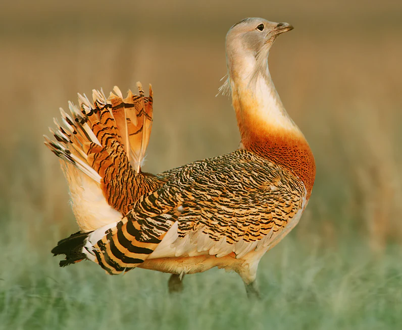
A side view of a male great bustard bird with its tail feathers fanned out and neck upright in a field.
A male great bustard in display posture within the Belziger Landschaftswiesen conservation area.

Belziger Landschaftswiesen ecosystems, habitats, and plant life

Ecologically the Belziger Landschaftswiesen are defined by the transition between open peatland, streams, meadows, and inland dunes, all set within a cold-influenced continental climate. The moors developed after a Holocene rise in the water table created extensive Durchströmungsmoor, a peatland watered by streams passing through it, and these moors originally carried large forests of alder, ash, oak, and hornbeam that have since been cleared, leaving only tiny remnant patches and making forest cover in the reserve as low as roughly 0.1 percent today.

In their place, decades of conservation effort have rebuilt a diverse grassland mosaic. Wetter, peaty areas carry foam-flower meadows with creeping buttercup, meadow foxtail, tall oat-grass, tufted hair-grass, and reed canary grass, while drier mineral soils support tall oat-grass fragments and pyrethrum grasslands, with sand-dry grasslands and rare lichen-pine forests restricted to the small inland dunes. The 245 recorded plant species include nationally or regionally rare taxa such as the splendid pink (Dianthus superbus), meadow saxifrage (Saxifraga granulata), common cowslip, snakeweed (Persicaria bistorta), and flowering rush (Butomus umbellatus), twenty-two of them listed on Brandenburg's Red List.

The streams and ditches harbor nineteen fish species, including the brook lamprey, gudgeon, stone loach, and nine-spined stickleback, while invertebrates range from the protected noble crayfish to dragonflies such as the banded demoiselle and the common clubtail, which establish territories along the Plane and its tributaries.
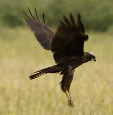
A dark-colored marsh harrier bird in flight, with wings spread against a blurred grassy background.
A marsh harrier in flight over the wetland landscape.

Belziger Landschaftswiesen wildlife and species highlights

The Belziger Landschaftswiesen are nationally significant for their bird fauna, counted at roughly 160 species with about 110 meadow breeders, thirty of them on Germany's Red List. The reserve is one of only a handful of remaining German strongholds of the great bustard (Otis tarda), a steppe bird whose once ample population had collapsed to around 150 individuals nationwide by 2003, with about 30 to 37 of those in the Belziger meadows under a dedicated protection program run from the Vogelschutzwarte Baitz.

Equally symbolic is the return of the corncrake (Crex crex), once driven out by mechanical mowing and now once again heard in dense meadow cover, alongside breeding lapwings, snipe, curlew, great bittern, common snipe, marsh harrier, and a wide cast of passage and wintering waterfowl such as gadwall, pintail, shoveler, teal, wigeon, white-fronted and bean geese, and whooper swans. An observation tower near Freienthal, on the Plane, allows visitors to watch many of these species without entering the protected core.

Mammals include roe deer, foxes, polecats, least weasels, raccoon dogs, and increasingly the European otter, while amphibians are represented by the protected natterjack toad (Bufo calamita) and garlic toad (Pelobates fuscus), both of which use the dune and wet-depression mosaic for breeding. Three strictly protected insects, the field cricket, the banded demoiselle, and the common clubtail dragonfly, round out a community shaped by the proximity of dry sandy sites and rich wet habitats.
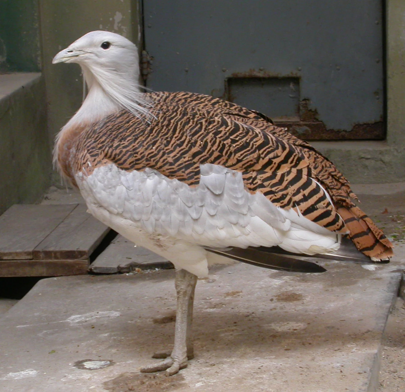
A Great Bustard standing on concrete, showing its white neck and barred brown and black wings.
A Great Bustard in a captive environment.

Belziger Landschaftswiesen conservation status and protection priorities

Conservation in the Belziger Landschaftswiesen is organized around the 2005 Brandenburg Nature Protection Ordinance, which divides the reserve into three management zones of varying agricultural intensity and ties the area into a regional biotope network with the Nuthe-Nieplitz lowlands, the Fiener Bruch, the middle Havel, and the Havelländisches Luch. Roughly 850 hectares of meadow were purchased by the state of Brandenburg and the Förderverein Großtrappenschutz in the 1990s to anchor this protection, and are now leased only to farmers operating under contract-based nature conservation rules.

At the heart of the program is the Durchströmungsmoor, whose water levels are carefully regulated by the Naturschutzstation Baitz in cooperation with local farmers and water boards to remove old weirs and restore near-natural stream courses. The same water regime, together with electric and mechanical wild-rescue devices, an absence of chemicals and fertilizers, and rotation of mowing dates after the corncrake breeding season, also underwrites the survival of meadow-breeding birds and an extraordinarily diverse invertebrate fauna.

The reserve is part of the EU Natura 2000 network as the Special Protection Area 'Unteres Rhinluch, Dreetzer See, Havelländisches Luch und Belziger Landschaftswiesen', and its highest-profile achievement is the stabilization and partial recovery of the great bustard through coordinated protection across the three Brandenburg-Saxony-Anhalt bustard reserves: the Belziger Landschaftswiesen, the Fiener Bruch, and the Havelländisches Luch.

Belziger Landschaftswiesen cultural meaning and human context

Culturally, the Belziger Landschaftswiesen are framed by a ring of villages whose small Feldsteinkirchen stone churches, manor houses, and watermills document the long human history of the Fläming and Zauche edges. Notable buildings near the reserve include Schinkel's Normalkirche at Lütte, Stüler's unusual half-timbered church at Dippmannsdorf, the octagonal church at Golzow, and historic manor houses and mill houses in Fredersdorf, Baitz, and Gömnigk that reflect Cistercian and Ascanian land development from the thirteenth century onward.

Until 1815 the meadows themselves served as a quiet but politically charged boundary between the Kingdom of Saxony on the Fläming side and the Kingdom of Prussia on the Zauche side; the surviving kursächsische Postmeilensäulen Saxon postal milestones at Bad Belzig and Brück still testify to this older order. The Brandenburgische Städtebahn, a single-track railway operating between 1904 and 1962, later traced the western edge of the meadows and once linked Treuenbrietzen, Bad Belzig, and Neustadt (Dosse), with the section toward Brandenburg an der Havel serving local villages until 2003.

Today the area is appreciated mostly by walkers, cyclists on the Europaradweg R1, and birdwatchers visiting the lookout near Freienthal, while traditional extensive farming continues through the cooperation between the Vogelschutzwarte Baitz, the Förderverein Großtrappenschutz, the local water boards, and the farming communities whose livelihoods still depend on hay, grazing, and the careful seasonal use of the valley.
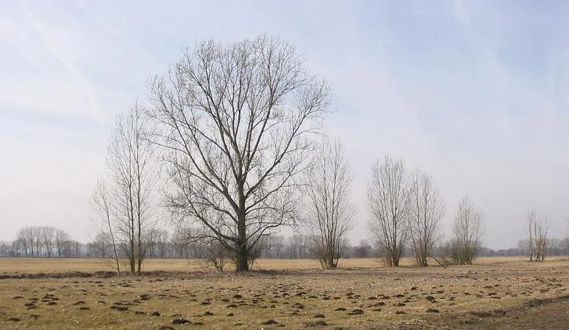
A wide, flat field in winter with bare trees scattered across the meadow under a pale, overcast sky.
Winter view of the open landscape in the Belziger Landschaftswiesen.

Top sights and standout views in Belziger Landschaftswiesen

The defining feature of the Belziger Landschaftswiesen is the rare Durchströmungsmoor itself, a through-flow peatland threaded by near-natural lowland streams around the River Plane, the Baitzer Bach, and the Belziger Bach; this is a once-common but now exceptional landscape type for Brandenburg, and it underpins almost every other conservation story in the reserve.

Equally distinctive is the role the meadows play as one of the last German strongholds of the great bustard: targeted habitat management, contract-based farming, and an observation program at the Vogelschutzwarte Baitz have helped stabilize this flagship bird while also supporting corncrakes, lapwings, snipe, curlews, and a winter influx of geese and swans. The contrast between the silent, almost treeless valley floor and the steep Fläming edge with the 200-meter Hagelberg adds a rare sense of openness to the Brandenburg Urstromtal experience.
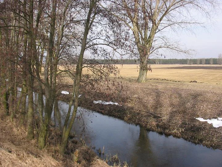
A narrow stream flows through a rural, open landscape with bare trees and lingering patches of snow on the ground in early spring.
The Plane stream flowing through the landscape of the Belziger Landschaftswiesen.

Best time to visit Belziger Landschaftswiesen

Spring and early summer are the most rewarding seasons for visiting the Belziger Landschaftswiesen, when the meadows are at their greenest, the drainage ditches and Plane are full of meltwater, and the breeding activity of meadow birds, including lapwing, snipe, and corncrake, is at its peak. Visibility from the observation tower near Freienthal is good during these months, and the higher flanks of the Fläming, including the Hagelberg at 200 meters, can be combined with lowland visits to encounter very different forest and heath scenery within a short drive.

In high summer the meadows turn rich with flowering aspects of blood willowherb, yarrow, and clovers, while autumn brings quieter, more atmospheric walks along the Europaradweg R1 as cooler continental air descends into the valley and early morning mists settle over the peatland. Winter visits are possible but quiet, with the higher Fläming slopes offering the most distinctive outlook over the snow-dusted lowland; birding interest then shifts to geese, swans, and overwintering raptors rather than breeding species.

Monthly climate preview

Long-term representative monthly temperature ranges and precipitation averages across the protected terrain

Belziger Landschaftswiesen Climate Normals, Annual Temperature and Precipitation Rhythm

Representative coordinates record mean temperatures ranging from sub-zero winter lows to warm summer highs alongside consistent year-round precipitation. Reviewing the complete twelve-month climatology profile provides deeper insight into measured meteorological patterns across the protected landscape.
Annual mean9 °C
0 °C20 °C
Jan
Feb
Mar
Apr
May14°
Jun18°
Jul20°
Aug20°
Sep15°
Oct
Nov
Dec
Warmest month
July

20 °C

Coolest month
January

-0.5 °C

Wettest month
July

2.4 mm/day

Driest month
April

1.1 mm/day

Park location guide

Geography guide, regional context, and park location map for Belziger Landschaftswiesen

Belziger Landschaftswiesen park geography, regions, and map view in Germany

Understand where Belziger Landschaftswiesen sits in Germany through a broader geographic reading of the surrounding landscape, nearby location context, and its mapped position within the national park landscape.

How Belziger Landschaftswiesen fits into Germany

Germany is a federal republic in Western and Central Europe with a population of over 83 million across sixteen constituent states. It is Europe's largest economy by nominal GDP and a major global exporter and importer. The capital is Berlin, and the country borders Denmark, Poland, Czech Republic, Austria, Switzerland, France, Luxembourg, Belgium, and the Netherlands.

Wider geography shaping Belziger Landschaftswiesen in Germany

Germany is located in Western and Central Europe, spanning 357,022 km². It borders Denmark to the north, Poland and the Czech Republic to the east, Austria and Switzerland to the south, and France, Luxembourg, Belgium, and the Netherlands to the west. The country has coastlines on the Baltic Sea and North Sea to the north, with the Alps located in the southern region.

Map view of Belziger Landschaftswiesen

Use this park location map to pinpoint Belziger Landschaftswiesen in Germany, understand its exact geographic position, and read its mapped placement within the surrounding landscape more clearly.

Pigeon | © OpenStreetMap contributors

Location context for Belziger Landschaftswiesen

Brandenburg

Visual reference for the glacial meltwater valley, peatlands, and open meadow terrain.

Belziger Landschaftswiesen Photos: Scenery, Landscapes, and Protected Habitats

Examine detailed visual records of Belziger Landschaftswiesen to understand the rare through-flow peatlands and open lowland meadows. Studying these protected habitats and glacial valley terrains reveals the distinctive geography and conservation character of the Brandenburg region.

A common snipe with mottled brown and cream plumage and a long, straight bill standing in shallow, reflective water.

A close up, low-angle shot of a mottled brown and black Natterjack toad sitting on wet soil amongst blades of green grass.

A side view of a male great bustard bird with its tail feathers fanned out and neck upright in a field.

A dark-colored marsh harrier bird in flight, with wings spread against a blurred grassy background.

A Great Bustard standing on concrete, showing its white neck and barred brown and black wings.

A Northern lapwing standing in tall green grass, showing its iridescent dark plumage and characteristic crest.

A wide, flat field in winter with bare trees scattered across the meadow under a pale, overcast sky.

A narrow stream flows through a rural, open landscape with bare trees and lingering patches of snow on the ground in early spring.

A brown, patterned bird with a speckled appearance perched on a tree branch amidst green foliage.

A wooden bird observation tower stands in an open, grassy lowland field near a large tree in Brandenburg, Germany.

A brown wooden sign post with green directional signs pointing to Freienthal and Cammer stands in a pine forest.

A wide view of open, flat, brownish fields in the Belziger Landschaftswiesen nature reserve with a large, leafless oak tree in the foreground and a distant line of buildings on the horizon.

A dirt path stretches through a lush green field toward a village with houses and a church steeple in the distance under a blue sky.

A lone birch tree stands in a dry, sparse grassy meadow under a pale sky, characteristic of the lowland fen landscape in Brandenburg.

A wide, horizontal view of flat, brownish fields characteristic of the Belziger Landschaftswiesen in Germany, featuring scattered deciduous trees in the midground and a hazy, muted horizon.

A small, fast-flowing stream surrounded by bare-branched trees and shrubs in early spring.

Park atlas

Compare adjacent wetland reserves and glacial valley protected landscapes

Parks Near Belziger Landschaftswiesen and Protected Areas in the Surrounding Region

Browsing other protected areas near Belziger Landschaftswiesen reveals connected ecological networks across the Brandenburg glacial meltwater valley. Comparing neighboring lowland reserves helps place regional wetland habitats and bird sanctuaries into a broader geographical context.
A watercolor illustration showing a landscape with small clusters of trees and grassy ground under a soft, light-filled sky.
Nature reserveBrandenburg
About 9.9 km away#1 closest

Northeast

Lehniner Mittelheide und Quellgebiet der Emster: Nature Reserve and Protected Landscape Atlas

Mapping Brandenburg inland heath and spring valley terrain

Examine the geographic layout of Lehniner Mittelheide und Quellgebiet der Emster, a nature reserve in the Brandenburg district of Potsdam-Mittelmark. This protected area connects dry sandy heathland with the aquatic corridors of the Emster headwaters and Mühlenteich pond, offering a clear example of glacial lowland landscape integration.

Area
6.4 km²
Established
1996
IUCN
IV
Relief
Lowland
Watercolor illustration of a rolling landscape with green hills, a winding stream, and coniferous trees on a white background.
Protected landscapeBrandenburg
About 18 km away#2 closest

South

Naturpark Hoher Fläming: A Protected Landscape Discovery in Brandenburg, Germany

Mapping glacial ridges, historic churches, and rural meadow lowlands.

Naturpark Hoher Fläming encompasses a vast protected landscape in Brandenburg, characterized by mature forested uplands and flat glacial valleys. Gain insight into the park's geomorphology, including its rare dry valleys and well-preserved medieval cultural sites, providing a structured look at one of Germany's significant natural regions.

Area
827 km²
Established
1997
Relief
Upland
Climate
Temperate
A soft watercolor illustration showing rolling green hills, a small stream winding through the foreground, and distant purple-toned peaks against a white background.
Nature reserveBrandenburg
About 22 km away#3 closest

Northeast

Glindower Alpen: Protected Nature Reserve and Clay Mining Geography in Brandenburg

A striking post-industrial landscape and nature reserve

Glindower Alpen is a 120-hectare nature reserve near Werder, Germany, characterized by an atypical terrain of deep ravines and ridges resulting from historical clay mining. This protected area stands out as an island of mixed deciduous forests and dry grasslands amidst the broader flat geography of the Brandenburg region.

Area
1.19 km²
Established
1995
Relief
Upland
Climate
Temperate
Watercolor painting of a lush, flat landscape with low green hills in the distance and wetland vegetation in the foreground.
Protected landscapeBrandenburg
About 25 km away#4 closest

North

Landschaftsschutzgebiet Brandenburger Osthavelniederung: Protected Landscape and Regional Geography

Mapped Havel River floodplain and glacial moraine terrain in Brandenburg.

Covering over 9,000 hectares, this protected landscape serves as a prime example of the Brandenburg Havel region. The area integrates a network of canals, dikes, and backwater lakes with isolated moraine ridges, creating a diverse geographic mosaic of river-managed lowlands and forested glacial remnants.

Area
93.81 km²
Established
1998
Relief
Lowland
Climate
Temperate
Nature reserveBrandenburg
About 26 km away#5 closest

Northeast

Naturschutzgebiet Krielower See: Protected Nature Reserve and Glacial Wetland Geography

Located in Brandenburg, this reserve protects a complex, silted-up lake basin and wetland network.

Naturschutzgebiet Krielower See protects a distinct glacial landscape near the Havel river. This 155-hectare nature reserve preserves a network of alder carr, reed beds, and wet meadows, providing an essential refuge for diverse species within the broader Havelland natural region. Explore the mapped topography and conservation context of this integral Brandenburg wetland habitat.

Area
1.55 km²
Established
2004
Relief
Lowland
Climate
Temperate
A soft watercolor illustration of a gentle river winding through green meadows and low hills under a hazy, warm sky.
Nature reserveBrandenburg
About 28 km away#6 closest

East

Europäisches Vogelschutzgebiet Nuthe-Nieplitz-Niederung Protected Area in Brandenburg

Glacial lake and river floodplain landscape context

This significant nature reserve forms a major ecological hub south of Berlin, characterized by its interplay of river floodplains, shallow glacial lakes, and open meadows. It is a critical site for breeding and migratory birds, offering a unique look at the hydrological systems and lowland geography that define the rural character of Brandenburg.

Area
61.44 km²
Established
2007
Relief
Lowland
Climate
Temperate
A panoramic watercolor illustration showing a meadow with green grasses, pink and purple wildflowers, shrubs, a misty water body, rolling green hills in the background, and a bird flying in a pale yellow sky
Protected landscapeBrandenburg
About 28 km away#7 closest

East

Naturpark Nuthe-Nieplitz: Geographic Overview of a Brandenburg Protected Landscape

Glacial river valleys and rewilded pine forest terrain

Naturpark Nuthe-Nieplitz represents a significant protected area in Brandenburg, Germany, characterized by its interconnected river lowlands and glacial features. The terrain features a rich mix of reed-fringed lakes, alder woodlands, and former military grounds currently undergoing ecological restoration. This overview traces the boundaries and landscape character of the park, providing essential context for its role in regional conservation.

Area
623.23 km²
Established
1999
Relief
Lowland
Climate
Temperate
A wide watercolor illustration depicting a calm river bordered by green grasses and shrubs, with soft pink and grey hills in the background.
Protected areaBrandenburg
About 29 km away#8 closest

West

Vogelschutzgebiet Fiener Bruch: Regional Geography and Protected Wetland Landscapes

A critical Natura 2000 sanctuary in the Brandenburg glacial valley.

The Vogelschutzgebiet Fiener Bruch functions as a large-scale wetland mosaic within the Glogau-Baruth Urstromtal, characterized by flat meadows and drainage channels. This protected area supports an intensive conservation landscape for great bustards and various waterbird populations, serving as an essential component of the regional natural geography in eastern Germany.

Area
100.05 km²
Established
1979
Relief
Lowland
Climate
Temperate

Common questions about visiting, size, designation, and location context for Belziger Landschaftswiesen

Belziger Landschaftswiesen FAQs for park facts, access, geography, and protected area context

Find quick answers about Belziger Landschaftswiesen, including protected-area facts, park geography, trail and visitor context, and how the park fits into its surrounding country and regional landscape.
MoriAtlas Explorer

Continue Your Protected Areas Search Across the Global Atlas

Deepen your exploration by continuing the structured search for national parks and protected areas worldwide. Utilize the comprehensive filtering capabilities to compare different conservation landscapes and refine your understanding of global park geography. Discover more about the distribution and characteristics of protected natural areas.

Global natural geography