
Mori Atlas logo
Nature reserveWachendorfer/Gödestorfer Bruch

A vital conservation area defined by alder swamp forests and active hydrological restoration

Wachendorfer/Gödestorfer Bruch Nature Reserve: Mapped Geography and Protected Wetland Landscapes

(Naturschutzgebiet Wachendorfer/Gödestorfer Bruch)

Wachendorfer/Gödestorfer Bruch serves as a crucial protected wetland landscape located in the Diepholz district of Lower Saxony. This nature reserve, composed of two distinct management units, preserves a rare mosaic of alder swamp forests, mixed riparian woodland, and open grassland. Through ongoing rewetting and habitat conversion, the area maintains its ecological character as a transitional zone between the northern peatlands and the sandy geest of northwestern Germany.

wetlandalder swamp forestriparian woodlandnature reserveLower SaxonyDiepholz district
A flat-style vector illustration depicting a mountain valley with a waterfall cascading down a cliff, a river flowing through the center, and evergreen trees in the foreground.

Wachendorfer/Gödestorfer Bruch

Nature reserve

Park overview

Structured park overview, official facts, and landscape profile for Wachendorfer/Gödestorfer Bruch

Wachendorfer/Gödestorfer Bruch park facts, protected area profile, and essential visitor context

Review the core facts for Wachendorfer/Gödestorfer Bruch, including designation, size, terrain, visitor scale, habitats, and operating context in one park-focused overview.

About Wachendorfer/Gödestorfer Bruch

Wachendorfer/Gödestorfer Bruch is a small but ecologically focused nature reserve in the Diepholz district of Lower Saxony, in northwestern Germany. Its setting places it firmly within the traditional transition zone between the Lower Saxon geest, with its sandy uplands, and the extensive moorlands that dominate parts of the district further north. The result is a landscape of gently sloping ground, historically shaped by wet conditions and small-scale agricultural use, where woodland and open land have long coexisted.

Geographically, the reserve is positioned about six kilometers east of the center of Syke, in the area around the Syke village districts of Wachendorf and Gödestorf. Rather than forming a single contiguous block, the protected area consists of two separate parcels of land: a northern area east of the core of Gödestorf, and a southern area east of the core of Wachendorf. Despite the gap between them, both sections are managed as one conservation unit and share similar hydrological and habitat conditions.

The character of the area is defined by wet woodland, with alder (Erle) swamp forests and alder-ash forests making up the core habitat structure. These wooded areas vary in their internal composition, with differences in tree age, density, and the openness of the canopy creating a mosaic of ecological niches. The reserve also contains grassland and some former arable land, providing a more open element within an otherwise woodland-dominated matrix.

Management of the reserve is oriented toward maintaining and improving this wetland character. The existing woodland is to be preserved and, where possible, enhanced through rewetting measures aimed at restoring higher water tables. Existing grassland is to be managed as extensively as possible, while former arable land is gradually being converted back into grassland. Together, these steps reflect a broader conservation approach that emphasizes hydrological restoration and the recovery of traditional, low-intensity land use patterns.

Quick facts and research context for Wachendorfer/Gödestorfer Bruch

Wachendorfer/Gödestorfer Bruch is a nature reserve (Naturschutzgebiet) in the Diepholz district of Lower Saxony, Germany. It lies approximately six kilometers east of the center of Syke, near the village districts of Wachendorf and Gödestorf. The reserve consists of two separated areas, a northern part east of Gödestorf and a southern part east of Wachendorf, which together cover around 195 hectares. It was officially designated as a nature reserve on 11 September 2000, with responsibility resting with the Diepholz district authority as the lower nature protection agency and oversight from the Lower Saxony State Agency for Water Management, Coastal Protection and Nature Conservation (NLWKN). The site is listed in international databases under the WDPA identifier 319263 and is treated as a habitat/species management area within the IUCN framework.

Protection and recognition

Documented terrestrial protection metrics and official conservation inventory data.

Wachendorfer and Gödestorfer Bruch Protection Status and Designated Area Record

Wachendorfer/Gödestorfer Bruch maintains a recorded terrestrial protection status within the global database repository. Conservation researchers review these official designation records to analyze management parameters and administrative frameworks across protected landscapes.

Protection details

Protection scope
Terrestrial
Transboundary protection
No
WDPA ID
319263
Park context

Deeper park guide and search-rich context for Wachendorfer/Gödestorfer Bruch

Wachendorfer/Gödestorfer Bruch history, landscape, wildlife, and travel context

Explore Wachendorfer/Gödestorfer Bruch through its history, landscape character, ecosystems, wildlife, conservation priorities, cultural context, and seasonal travel timing in a structured park guide built for atlas discovery and search intent.

Why Wachendorfer/Gödestorfer Bruch stands out

The reserve is best known for its wet woodland, particularly alder swamp forests and mixed alder-ash woodland that have developed under the influence of persistent groundwater conditions. Alongside these wooded areas, a patchwork of wet grassland and former arable fields defines the reserve. The defining landscape feature is the interaction between forested lowlands and waterlogged meadows, a combination that is characteristic of the transitional zone between the sandy geest and the peatlands further north in the Diepholz district. Beyond its woodland character, the reserve is also recognized for its role within the broader network of small wetland reserves in the Diepholz district. Its relative isolation from intensive land use and the active hydrological management together give it conservation value well beyond its modest size.
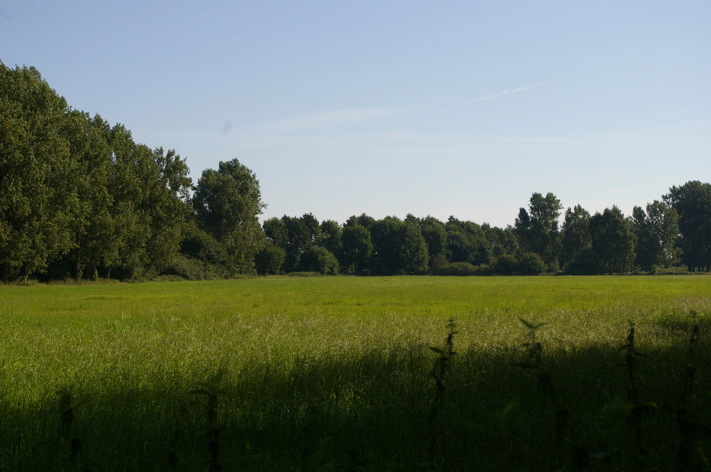
A wide, eye level landscape view of a green grassy field bordering a dense line of trees under a clear, pale blue sky.
A view across the green meadows and swamp forest edge of the Wachendorfer/Gödestorfer Bruch nature reserve.

Wachendorfer/Gödestorfer Bruch history and protected-area timeline

Wachendorfer/Gödestorfer Bruch was formally designated as a nature reserve by legal ordinance on 11 September 2000. The designation united two existing wetland areas around the villages of Wachendorf and Gödestorf into a single protected entity, classified under the NSG identifier HA 199 within the Lower Saxon system of nature reserves.

The context for the designation lies in the broader recognition of small, fragmented wetland sites across the Diepholz district. Although the area around Syke has long been influenced by agriculture, the persistence of wet conditions along the margins of the geest has allowed alder woodland and wet grassland to survive in locations that were never fully reclaimed for large-scale cultivation. The 2000 ordinance formalized protection for these surviving habitats and established a framework for management.

Responsibility for the reserve lies with the Diepholz district as the lower nature protection authority, while the Lower Saxony State Agency for Water Management, Coastal Protection and Nature Conservation (NLWKN) provides higher-level oversight and technical support. Since its designation, the reserve has been integrated into regional databases, including a World Database on Protected Areas entry with the identifier 319263, reflecting its role within wider national and European conservation frameworks.

Wachendorfer/Gödestorfer Bruch landscape and geographic character

The landscape of Wachendorfer/Gödestorfer Bruch is shaped by its position along the southern edge of the broader Diepholz moorland region, just north of the sandy geest of central Lower Saxony. Elevation within the reserve is modest and uneven, ranging roughly between about ten and thirty meters above sea level. This gentle topographic variation, combined with persistently high groundwater, has produced a mosaic of wet woodland and open wetland habitats rather than any sharp or dramatic landscape features.

The two protected areas, one north of Wachendorf and one south of Gödestorf, sit within a wider agricultural landscape in which fields, meadows, and small woodland patches alternate. Within the reserve boundaries, however, the landscape transitions toward a denser cover of alder-dominated swamp woodland, interspersed with patches of alder-ash forest and small areas of open grassland. The woodland structure is varied: some stands are dense and dark, while others are more open and structurally diverse.

Water is the defining feature of the landscape, although it is rarely visible as open surface water. Instead, wet soils, saturated peat substrates, and shallow groundwater shape the vegetation and the surface character of the land. This hidden hydrology is central to the reserve's identity and is also the focus of ongoing rewetting measures aimed at strengthening its wetland character.

Wachendorfer/Gödestorfer Bruch ecosystems, habitats, and plant life

Ecologically, Wachendorfer/Gödestorfer Bruch belongs to the wetland habitats that fringe the Lower Saxon geest. The vegetation is dominated by alder swamp forest, in which alder (Alnus) is the principal tree species, often accompanied by ash in the slightly better-drained transitional zones. These wooded areas reflect long-term adaptation to waterlogged, nutrient-rich soils and represent one of the more characteristic forest types of northwestern Germany.

Alongside the closed woodland, the reserve contains grassland of varying moisture and intensity. Some of this grassland retains a more traditional, species-rich character, while other parts were formerly cultivated as arable fields. The management approach seeks to strengthen the wet grassland component by reducing former arable areas and encouraging more extensive use of surviving meadows.

The combination of wet woodland and wet grassland creates habitat diversity within a relatively compact area. Small variations in elevation, hydrology, and soil conditions produce transitions between dense forest, open canopy woodland, and open meadow. This mosaic supports a wider range of species than any single habitat type would on its own, and provides the basis for the reserve's value as a habitat and species management area within the IUCN framework.

Wachendorfer/Gödestorfer Bruch wildlife and species highlights

The wildlife of Wachendorfer/Gödestorfer Bruch is closely tied to its wetland character. The alder swamp forests and surrounding wet meadows provide habitat for a range of species adapted to moist conditions and structurally diverse woodland. Amphibians, in particular, benefit from the saturated soils and seasonal surface wetness found in parts of the reserve, and the area is recognized as a habitat for amphibian species typical of northwestern German wetlands.

The varied woodland structure, with a mix of dense, mature stands and more open, younger trees, also supports a diverse bird community, including woodland species associated with wet forest habitats. The presence of grassland interspersed with woodland edges further increases habitat diversity, providing opportunities for ground-nesting and edge-using species.

While specific large mammal populations are not the focus of the reserve, the wet woodland and mosaic of habitats support populations of typical forest mammals, as well as invertebrates linked to decaying wood, damp leaf litter, and wet meadow vegetation. The overall management approach of preserving and rewetting the woodland is intended to maintain and strengthen these wildlife communities over time.

Wachendorfer/Gödestorfer Bruch conservation status and protection priorities

Wachendorfer/Gödestorfer Bruch is classified as an IUCN Category IV protected area, meaning it is managed primarily for the conservation of specific habitats and species. Within Germany, this corresponds to its status as a formal Naturschutzgebiet under Lower Saxon nature protection law, designated by ordinance on 11 September 2000.

The reserve's central conservation priority is the protection and restoration of its wet woodland habitats, particularly the alder swamp forests and alder-ash forests that depend on consistently high water tables. To this end, rewetting measures are being implemented to improve hydrological conditions in the existing woodland. At the same time, the management program aims to replace remaining arable land within the reserve boundaries with grassland, and to maintain existing grassland under extensive, low-intensity use.

Although the reserve is modest in size at around 195 hectares, it plays an integrated role within the Diepholz district's wider network of protected wetlands and forests, contributing to the regional goal of maintaining habitat connectivity and ecological quality in the transitional zone between the geest and the moors.

Wachendorfer/Gödestorfer Bruch cultural meaning and human context

The cultural context of Wachendorfer/Gödestorfer Bruch is rooted in the long-standing rural land use patterns of the Syke area. The names Wachendorf and Gödestorf refer to historical village communities whose agricultural activity historically shaped the rural landscape between the geest and the moorlands. Wet areas unsuitable for intensive cultivation often remained as woodland or rough grazing land, and these traditional uses helped establish the mosaic of habitats that the reserve now protects.

The persistence of forests and meadows in this area reflects centuries of adaptation to local soil and water conditions. While the modern nature reserve is a product of 20th and 21st century conservation law, its underlying landscape pattern has older rural origins, illustrating how historical low-intensity land use can serve as a foundation for present-day biodiversity conservation.

Top sights and standout views in Wachendorfer/Gödestorfer Bruch

The principal highlights of Wachendorfer/Gödestorfer Bruch are its surviving alder swamp forests, its mosaic of wet woodland and grassland, and its active restoration through rewetting of degraded forests and conversion of arable land to more ecologically valuable grassland.

Also notable is the reserve's role as part of the wider system of protected wetlands in the Diepholz district, and its formal integration into both regional and international conservation frameworks, including the World Database on Protected Areas under the identifier 319263.

Best time to visit Wachendorfer/Gödestorfer Bruch

The reserve is most atmospheric in spring, when rising water tables and early growth bring renewed activity to the wet woodland and meadows, and again in early autumn, when the alder-dominated forests take on warm seasonal colors. Summer visits highlight the density and luxuriance of the green alder canopy, while winter offers a quieter view of the underlying woodland structure and the open character of the grassland areas. The reserve is managed primarily for conservation, so any visit should focus on quiet, low-impact enjoyment of the wetland landscape rather than on active recreation.

Monthly climate preview

Long term monthly temperature and precipitation averages recorded at a representative coordinate

Wachendorfer and Gödestorfer Bruch Climate Normals, Temperature and Precipitation Rhythm

Representative coordinates record measured monthly temperature and precipitation cycles across the conservation landscape, establishing a long term climatological baseline from NASA data between 1991 and 2020. Examining the complete twelve month profile provides deeper insight into shifting thermal ranges and precipitation distribution patterns across the area.
Annual mean9 °C
1 °C18 °C
Jan
Feb
Mar
Apr
May13°
Jun16°
Jul18°
Aug18°
Sep14°
Oct10°
Nov
Dec
Warmest month
July

18 °C

Coolest month
January

1 °C

Wettest month
July

2.5 mm/day

Driest month
April

1.4 mm/day

Park location guide

Geography guide, regional context, and park location map for Wachendorfer/Gödestorfer Bruch

Wachendorfer/Gödestorfer Bruch park geography, regions, and map view in Germany

Understand where Wachendorfer/Gödestorfer Bruch sits in Germany through a broader geographic reading of the surrounding landscape, nearby location context, and its mapped position within the national park landscape.

How Wachendorfer/Gödestorfer Bruch fits into Germany

Germany is a federal republic in Western and Central Europe with a population of over 83 million across sixteen constituent states. It is Europe's largest economy by nominal GDP and a major global exporter and importer. The capital is Berlin, and the country borders Denmark, Poland, Czech Republic, Austria, Switzerland, France, Luxembourg, Belgium, and the Netherlands.

Wider geography shaping Wachendorfer/Gödestorfer Bruch in Germany

Germany is located in Western and Central Europe, spanning 357,022 km². It borders Denmark to the north, Poland and the Czech Republic to the east, Austria and Switzerland to the south, and France, Luxembourg, Belgium, and the Netherlands to the west. The country has coastlines on the Baltic Sea and North Sea to the north, with the Alps located in the southern region.

Map view of Wachendorfer/Gödestorfer Bruch

Use this park location map to pinpoint Wachendorfer/Gödestorfer Bruch in Germany, understand its exact geographic position, and read its mapped placement within the surrounding landscape more clearly.

Pigeon | © OpenStreetMap contributors

Location context for Wachendorfer/Gödestorfer Bruch

Lower Saxony

Visualizing the alder swamp forests, wet meadows, and terrain character of Lower Saxony

Wachendorfer/Gödestorfer Bruch Photos and Protected Wetland Landscapes

Visual records capture the distinctive alder swamp forests and waterlogged meadows that define Wachendorfer/Gödestorfer Bruch. Examining these protected habitats clarifies the complex hydrology and transitional terrain of the Diepholz district.

A wide, eye level landscape view of a green grassy field bordering a dense line of trees under a clear, pale blue sky.

Park atlas

Compare adjacent wetland reserves and regional lowland landscapes

Parks Near Wachendorfer/Gödestorfer Bruch and Surrounding Protected Areas

Browsing other protected areas near Wachendorfer/Gödestorfer Bruch reveals connected wetland reserves and alder swamp forests across the Diepholz district. Evaluating these adjacent conservation units provides deeper geographic context for the transitional lowland terrain of Lower Saxony.
Protected landscapeBremen
About 14 km away#1 closest

North

Mahndorfer Marsch Protected Landscape: Weser River Floodplain and Wetland Atlas

A river-driven marshland corridor in Bremen, Germany

The Mahndorfer Marsch is a protected landscape characterized by its classic Weser floodplain terrain, featuring a network of meadows, channels, and water bodies. Spanning the boundary between Bremen and Lower Saxony, this area provides an essential refuge for migratory bird populations. Understanding the marshland topography offers insight into the historical flood dynamics and environmental preservation of the lower Weser valley.

Area
15.36 km²
Established
2015
IUCN
V
Protected landscapeBremen
About 15 km away#2 closest

North

Mahndorfer Düne: A Protected Inland Dune Landscape in the City of Bremen

Geological remnants and ecological layering in Northwest Germany.

Mahndorfer Düne is a distinct protected landscape in Bremen, Germany, functioning as one of the final surviving inland dune relics from the Ice Age. The 2.7 hectare area maps a layered transition of sandy soil, dry heathland, and birch-oak woodland, offering an important look at regional post-glacial geology and conservation within a dense urban setting.

Area
0.027 km²
Established
1985
Relief
Lowland
Climate
Temperate
Nature reserveBremen
About 16 km away#3 closest

North

Vogelschutzgebiet Arsten-Habenhausen: Mapping the Protected Weser Floodplain Habitat

A historic urban nature reserve located in Bremen

Located in the Habenhausen district of Bremen, Vogelschutzgebiet Arsten-Habenhausen is a significant protected area focused on river floodplain maintenance. The site provides a concentrated view of floodplain woodland and reedbed vegetation, illustrating how small, long-established nature reserves contribute to the regional geography of the Weser river corridor in Germany.

Area
0.01 km²
Established
1950
IUCN
IV
Relief
Lowland
Watercolor painting of a wide, rolling landscape with green trees, golden fields, and soft hills in the background.
Protected areaGermany
About 17 km away#4 closest

North

Krietes Wald (Im Holze) Protected Area: Landscape and Geographic Atlas Summary

A critical urban forest node in the Bremen region of Germany.

Krietes Wald (Im Holze) serves as a significant nature reserve characterized by its mature beech and oak-hornbeam woodland. Spanning a narrow, protected corridor in eastern Bremen, the site provides dense habitat value within an industrial landscape. It stands as a regional reference for saproxylic insect conservation and structural forest development within the federal republic of Germany.

Area
0.083 km²
Established
2015
Relief
Lowland
Climate
Temperate
Nature reserveLower Saxony
About 20 km away#5 closest

Southeast

Wiedesee Nature Reserve: Mapped Geography and Protected Landscapes in Lower Saxony

A compact waterbird habitat in the Lower Saxony agricultural region

Wiedesee stands as a refined example of a managed nature reserve in Germany. Spanning 26 hectares, this former quarrying lake is defined by its concentric transition from open water and reed belts to wet meadow fringes. The site serves as a vital island of biodiversity, offering a clear case study in how active conservation interventions support migratory bird species within an otherwise intensively farmed landscape.

Area
0.26 km²
Established
1984
Water
Water-dominated
Nature reserveBremen
About 23 km away#6 closest

Northwest

Ochtumniederung bei Brokhuchting: Wetland Nature Reserve and Floodplain Geography

A core conservation area within the Bremen Niedervieland

This protected area stands as a primary example of large-scale river floodplain restoration in the Bremen region. The landscape includes a dense network of canals, reedbeds, and seasonal flood zones that provide critical shelter for waterfowl and waders. Through careful environmental management, this site integrates natural riverine terrain with the surrounding industrial and urban framework of northwestern Germany, offering a distinct study of managed wetland ecosystems.

Area
3.75 km²
Established
1998
Relief
Lowland
Climate
Temperate
A pale, soft-toned watercolor illustration of a calm river meandering through open, green marshy meadows with distant rolling hills under a soft pink sky.
Nature reserveBremen
About 23 km away#7 closest

North

Borgfelder Wümmewiesen: Protected Wetland and Floodplain Geography in Bremen

An expansive 688-hectare nature reserve with river-fed grasslands.

Borgfelder Wümmewiesen offers a look at one of the largest protected nature reserves in the Bremen region. The landscape is characterized by its flat, open terrain and regular water dynamics that frame a rich mosaic of wet meadows, reedbeds, and ponds, providing essential habitat for breeding and migratory bird species along the Wümme river corridor.

Area
6.88 km²
Established
1987
Relief
Lowland
Climate
Temperate
A soft, painterly watercolor illustration depicting a winding river through a flat green meadow with rolling hills in the background.
Nature reserveBremen
About 24 km away#8 closest

North

Hollerland Nature Reserve: A Protected Cultural Landscape and Wetland in Bremen

Historic marshland terrain with unique saline spring ecosystems

Hollerland is a 293-hectare nature reserve in Bremen, Germany, notable for its well-preserved cultural landscape of wet grasslands and an intricate medieval ditch network. This protected area serves as a critical breeding ground for meadow birds and hosts an ecologically significant inland saline spring, providing a rare habitat for brackish-adapted plant communities deep within the regional landscape.

Area
2.93 km²
Established
1985
IUCN
IV
Relief
Lowland

Common questions about visiting, size, designation, and location context for Wachendorfer/Gödestorfer Bruch

Wachendorfer/Gödestorfer Bruch FAQs for park facts, access, geography, and protected area context

Find quick answers about Wachendorfer/Gödestorfer Bruch, including protected-area facts, park geography, trail and visitor context, and how the park fits into its surrounding country and regional landscape.
MoriAtlas Explorer

Continue Your Protected Areas Search Across the Global Atlas

Deepen your exploration by continuing the structured search for national parks and protected areas worldwide. Utilize the comprehensive filtering capabilities to compare different conservation landscapes and refine your understanding of global park geography. Discover more about the distribution and characteristics of protected natural areas.

Global natural geography