
Mori Atlas logo
Nature reserveWerra-Aue zwischen Breitungen und Creuzburg

Geographic atlas and ecological mapping of this Thuringian river corridor sanctuary

Werra-Aue zwischen Breitungen und Creuzburg Nature Reserve and Floodplain Landscape

The Werra-Aue zwischen Breitungen und Creuzburg nature reserve spans a 2,578 hectare floodplain along the middle Werra river in western Thuringia. This protected area features a complex mosaic of sinkhole lakes, oxbows, reedbeds, and wet meadows shaped by deep geological salt dissolution. It serves as a vital European bird sanctuary and conservation node, preserving open grasslands and remnant floodplain woodlands that support diverse waterbirds and meadow-breeding species.

floodplainriver valleyWerrabird sanctuarySpecial Protection AreaNatura 2000
A digital illustration of a river valley scene with flowering branches in the foreground, a winding river in the middle ground, and rolling hills in the background, with a silhouette of a bull standing on the riverbank.

Werra-Aue zwischen Breitungen und Creuzburg

Nature reserve

Park overview

Structured park overview, official facts, and landscape profile for Werra-Aue zwischen Breitungen und Creuzburg

Werra-Aue zwischen Breitungen und Creuzburg park facts, protected area profile, and essential visitor context

Review the core facts for Werra-Aue zwischen Breitungen und Creuzburg, including designation, size, terrain, visitor scale, habitats, and operating context in one park-focused overview.

About Werra-Aue zwischen Breitungen und Creuzburg

Werra-Aue zwischen Breitungen und Creuzburg is a long, ribbon-like floodplain protected area that traces the Werra river through western Thuringia, connecting the communities of Breitungen and Creuzburg. Functioning as a Special Protection Area within the European Natura 2000 network, it brings together an unusually rich combination of subsidence lakes, abandoned river arms, extensive reedbeds, waterlogged meadows, and surviving floodplain forest fragments. The result is a habitat mosaic that supports both resident species and large numbers of migratory waterbirds, waders, and raptors.

The Werra itself flows through the area for about 33.6 kilometers, broadening from more than 20 meters at the southern entrance near Breitungen to more than 30 meters near Creuzburg in the north. Although the river's water quality in the upper reaches is only moderately affected, downstream salt inputs from the potash mining industry along the Werra have impaired ecological conditions, with ecological status rated unsatisfactory near Vacha and poor further downstream. Despite this pressure, the floodplain retains significant value because of its size, structural diversity, and the way traditional extensive land use continues alongside conservation management.

Within the SPA, twelve nature reserves and three FFH sites overlap the bird protection area, creating a layered network of national and European designations. Areas such as the Breitunger Seen, Forstloch, Erlensee, Karrenwiesen, Brühl von Merkers, Alte Werra, Werraaue bei Berka und Untersuhl, and Wilhelmsglücksbrunn contribute distinct microhabitats, from open water and marsh to species-rich meadows. The region lies at the boundary between the Osthessisches Bergland (East Hessian Highlands) and the Thuringian Basin, which adds further habitat complexity through transitions from broad floodplain to adjacent slopes of Buntsandstein and Muschelkalk.

Beyond its formal designations, the Werra-Aue is also woven into the regional experience of the landscape. The Werratal-Radweg, a long-distance cycling route, traces the river from its sources in the Thuringian Slate Mountains to its confluence with the Fulda at Hann. Münden, and runs through or alongside the protected area, opening up views into the sanctuary. Selected footpaths with bird observation hides and information panels allow careful, low-disturbance exploration for those interested in the area's birdlife. Together, these qualities make the Werra-Aue zwischen Breitungen und Creuzburg a quietly significant stretch of European floodplain, both ecologically and culturally anchored in the Werra valley.

Quick facts and research context for Werra-Aue zwischen Breitungen und Creuzburg

Werra-Aue zwischen Breitungen und Creuzburg covers approximately 2,578 hectares and runs along about 33.6 kilometers of the Werra river in western Thuringia. It lies mainly in the Wartburgkreis, with only its southernmost section falling within the Landkreis Schmalkalden-Meiningen. The area carries the EU Natura 2000 site code 5127-401, the Thuringian internal designation SPA 18, and the WDPA code 555537614, and it has been listed as a Special Protection Area under the European Birds Directive since 2007. Elevations within the floodplain range from about 189 meters to 250 meters above sea level. The area is managed by the Thüringer Landesamt für Umwelt, Bergbau und Naturschutz (TLUBN).

Protection and recognition

Documented terrestrial protection scope, designation year, and Natura 2000 recognition

Werra-Aue zwischen Breitungen und Creuzburg Protection Status and Designation History

Terrestrial protection status for Werra-Aue zwischen Breitungen und Creuzburg outlines a designated management history established in 2008. Official conservation records include recorded Natura 2000 recognition sources linked directly to the protected landscape profile.

International recognition

Protection details

Protection scope
Terrestrial
Designated year
2008
Transboundary protection
No
WDPA ID
555537614
Park context

Deeper park guide and search-rich context for Werra-Aue zwischen Breitungen und Creuzburg

Werra-Aue zwischen Breitungen und Creuzburg history, landscape, wildlife, and travel context

Explore Werra-Aue zwischen Breitungen und Creuzburg through its history, landscape character, ecosystems, wildlife, conservation priorities, cultural context, and seasonal travel timing in a structured park guide built for atlas discovery and search intent.

Why Werra-Aue zwischen Breitungen und Creuzburg stands out

The Werra-Aue between Breitungen and Creuzburg is especially known as one of Thuringia's most important floodplain bird sanctuaries, protecting large populations of waterbirds, meadow-breeding waders, and raptors along the middle Werra. It is recognized for its mosaic of subsidence lakes, oxbows, reedbeds, wet meadows, and remnant floodplain woodland, all within a structurally rich river corridor. The area is also notable for overlapping multiple national nature reserves, FFH sites, and floodplain protections, making it a particularly layered example of integrated European habitat conservation.
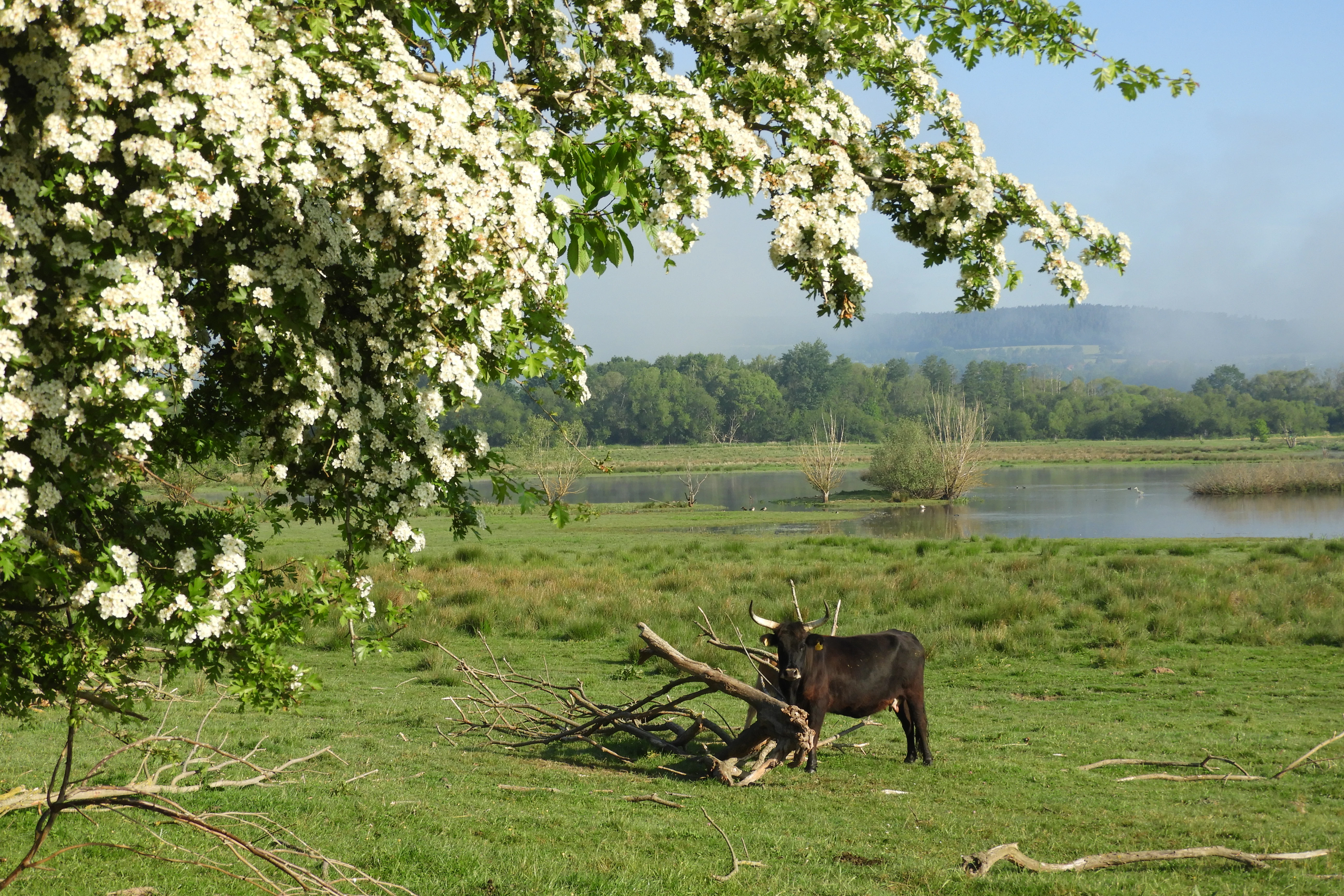
A peaceful landscape view of a green wetland meadow with a dark-colored cow standing near a pile of branches; white hawthorn blossoms hang in the foreground, and a calm body of water stretches into the misty background.
The Dankmarshäuser Rhäden wetland, a vital floodplain habitat for waterbirds along the Werra River.

Werra-Aue zwischen Breitungen und Creuzburg history and protected-area timeline

The protected status of the Werra-Aue zwischen Breitungen und Creuzburg emerged from the European Union's efforts to halt the decline of wild bird populations through its Birds Directive. In October 2003, the Thuringian Ministry for the Environment proposed the area as a Special Protection Area under this directive, and the proposal was forwarded to the European Union via the German Federal Ministry for the Environment. Once proposed, the site became legally part of the Natura 2000 network, even before formal confirmation.

Official confirmation came on 26 July 2007, when Germany's Federal Environment Ministry announced the European bird protection areas and published the designation in the Bundesanzeiger. The Thuringian Natura 2000 Conservation Objectives Ordinance of 29 May 2008 then codified the specific bird species and habitat targets for the site, formalizing the area's role in protecting breeding, feeding, and resting habitats for a defined list of conservation-relevant birds. The area had previously been shaped for centuries by traditional agricultural use, including extensive grazing in meadows such as the Dankmarshäuser Rhäden, which had already maintained open, bird-favorable landscapes long before formal conservation designations.

Werra-Aue zwischen Breitungen und Creuzburg landscape and geographic character

The Werra-Aue is a wide, low-lying river valley with elevations ranging from roughly 189 to 250 meters above sea level, framed by the gently rising slopes of the surrounding Thuringian and Hessian highlands. Its most distinctive physical features come from a long geological history of salt dissolution deep below the surface. Overlying Zechstein salt deposits, laid down in the late Permian, have gradually dissolved and collapsed, producing surface subsidence that has widened the floodplain and created characteristic sinkhole lakes such as the Breitunger Seen and the Forstloch south of Barchfeld.

The present-day floodplain is a mosaic of large open meadows and pastures, some of which are seasonally flooded by the Werra, interspersed with reedbeds, old river arms, gravel pit ponds, clay pit pools, and fragments of former floodplain forest. Old channels such as the Alte Werra and the Werraaltarm near Gerstungen create quieter backwaters that contrast with the main river. Along the slopes and edges, the geology transitions from Lower and Middle Buntsandstein sandstones to localized Zechstein outcrops near Bad Salzungen and Muschelkalk and Keuper sediments around the northern section near Wilhelmsglücksbrunn, lending the broader landscape a layered geological character beneath the floodplain's green cover.
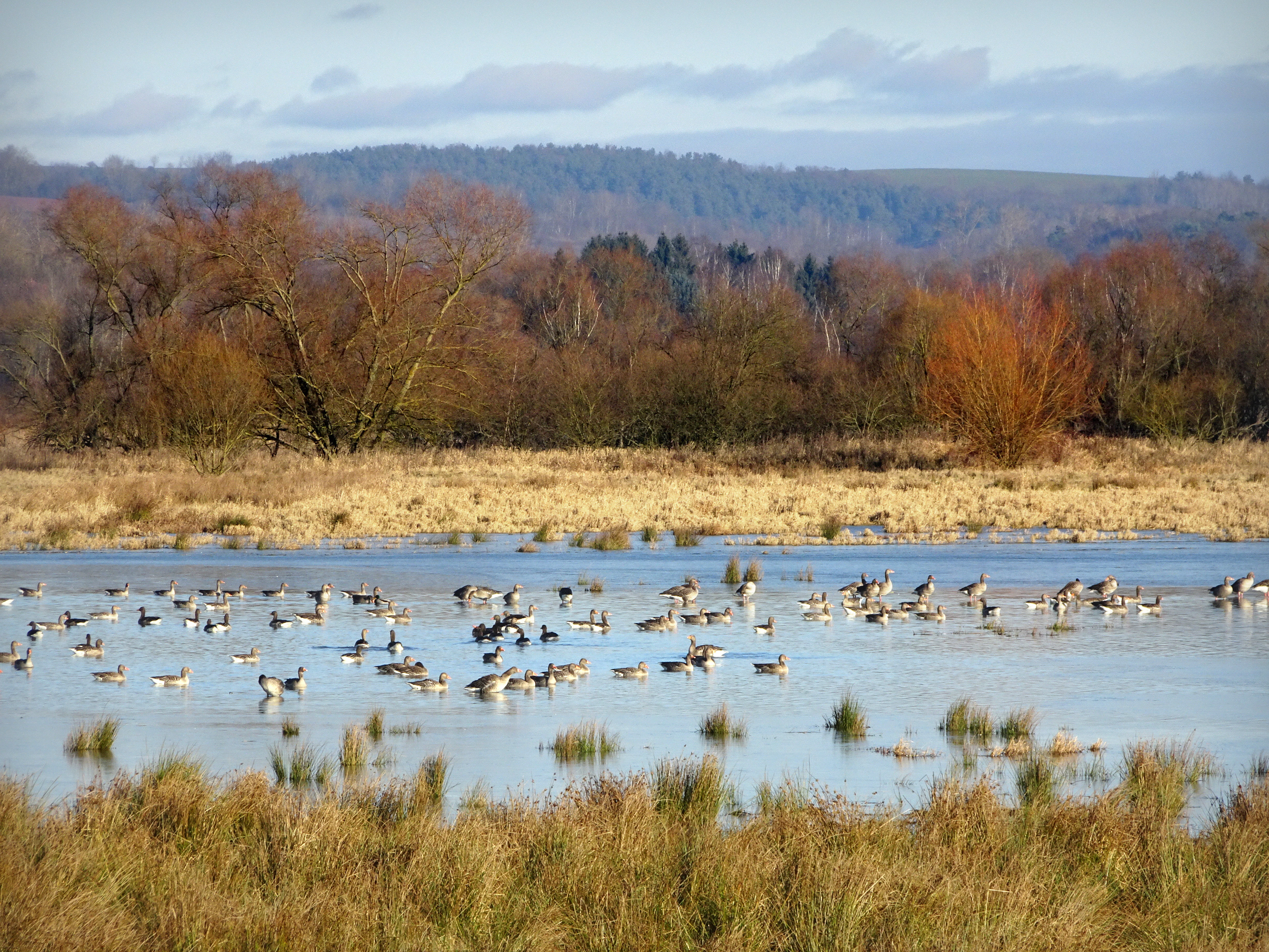
A large flock of geese swimming in a shallow, marshy wetland with golden-brown grasses and deciduous trees in the background under a blue sky.
A flock of greylag geese gathered in the wetland habitat of the Dankmarshäuser Rhäden nature reserve.

Werra-Aue zwischen Breitungen und Creuzburg ecosystems, habitats, and plant life

Ecologically, the Werra-Aue functions as a textbook example of a Central European lowland river floodplain. Its habitat structure alternates between open water, reed-fringed backwaters, seasonally flooded meadows, dry grassland fringes, scrubby transitions, and patches of alder and willow floodplain forest. These contrasting microhabitats sit within a relatively short stretch of river, supporting both aquatic and terrestrial communities and allowing sensitive species to find refuge even under changing conditions.

Near-natural vegetation in the area would largely consist of Stellaria oak-hornbeam forests together with riverside alder and willow woodland, which are characteristic of broad valley floors with periodically or permanently moist soils. Depending on local hydrology, stands of true floodplain forest, swamp forest, and bog forest also occur. Soil variability plays a major ecological role: in the upper section near Immelborn, thick layers of loess-like floodplain loam overlie older silty-clay Holocene sediments, while downstream the floodplain is built on acidic sandy substrates prone to leaching, producing a gradient of soil conditions within a single coherent river system.
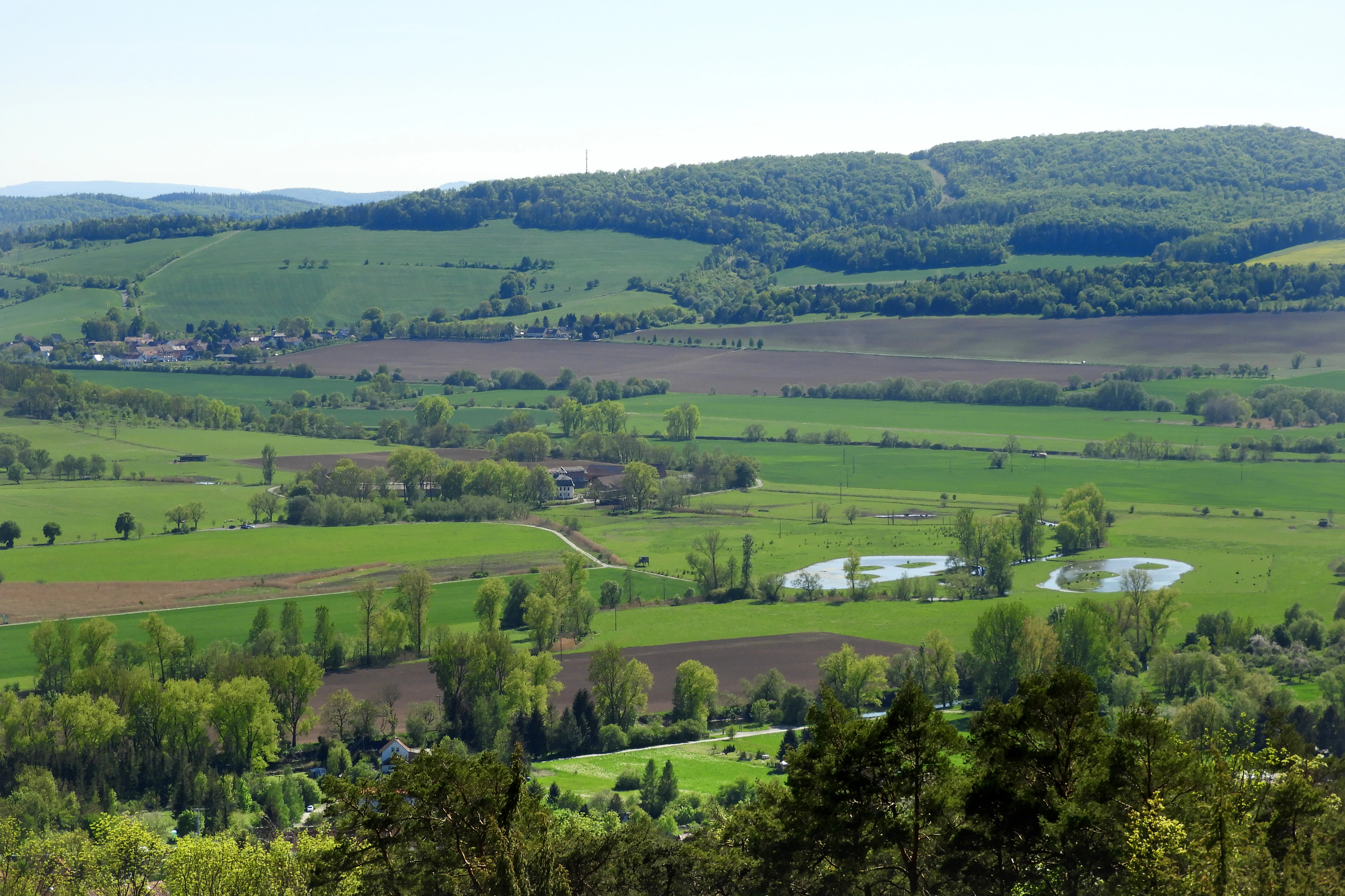
A wide aerial view of a lush green river valley with open meadows, scattered trees, and several small ponds under a clear sky.
A view over the green floodplain meadows and small ponds of the Werra-Aue near Wilhelmsglücksbrunn.

Werra-Aue zwischen Breitungen und Creuzburg wildlife and species highlights

The Werra-Aue zwischen Breitungen und Creuzburg is fundamentally a bird-focused protected area, and its wildlife importance centers on the rich avifauna that inhabits and passes through the floodplain. The EU Birds Directive standard data form recorded twenty Annex I species as breeding birds or feeding visitors during the breeding season, including iconic species such as the Common Kingfisher, Great Bittern, White Stork, Black Stork, Marsh Harrier, Corncrake, Black Woodpecker, Great Egret, Common Crane, Black-winged Stilt, Little Bittern, Red-backed Shrike, Bluethroat, Black Kite, Red Kite, European Honey Buzzard, Grey-headed Woodpecker, Eurasian Spoonbill, Little Crake, and Spotted Crake.

Subsequent Thuringian conservation objectives broadened this list with additional Annex I species such as Wood Sandpiper, Osprey, European Golden Plover, Ruff, Hen Harrier, Whooper Swan, Black Tern, Little Gull, and Smew. Fifty-one migratory bird species in total are considered relevant to the area's designation, and the floodplain is recognized as an important staging and wintering site for waterfowl, waders, raptors, and amphibious birds. Among meadow-breeding specialists particularly associated with the area are Lapwing, Common Snipe, Whinchat, Meadow Pipit, Common Quail, Eurasian Wryneck, and Corncrake, while wooded wetland edges support Bluethroat, Icterine Warbler, River Warbler, and Black Kite. The presence of late-mown or grazed meadows is actively managed to protect ground-nesting species from agricultural disturbance.
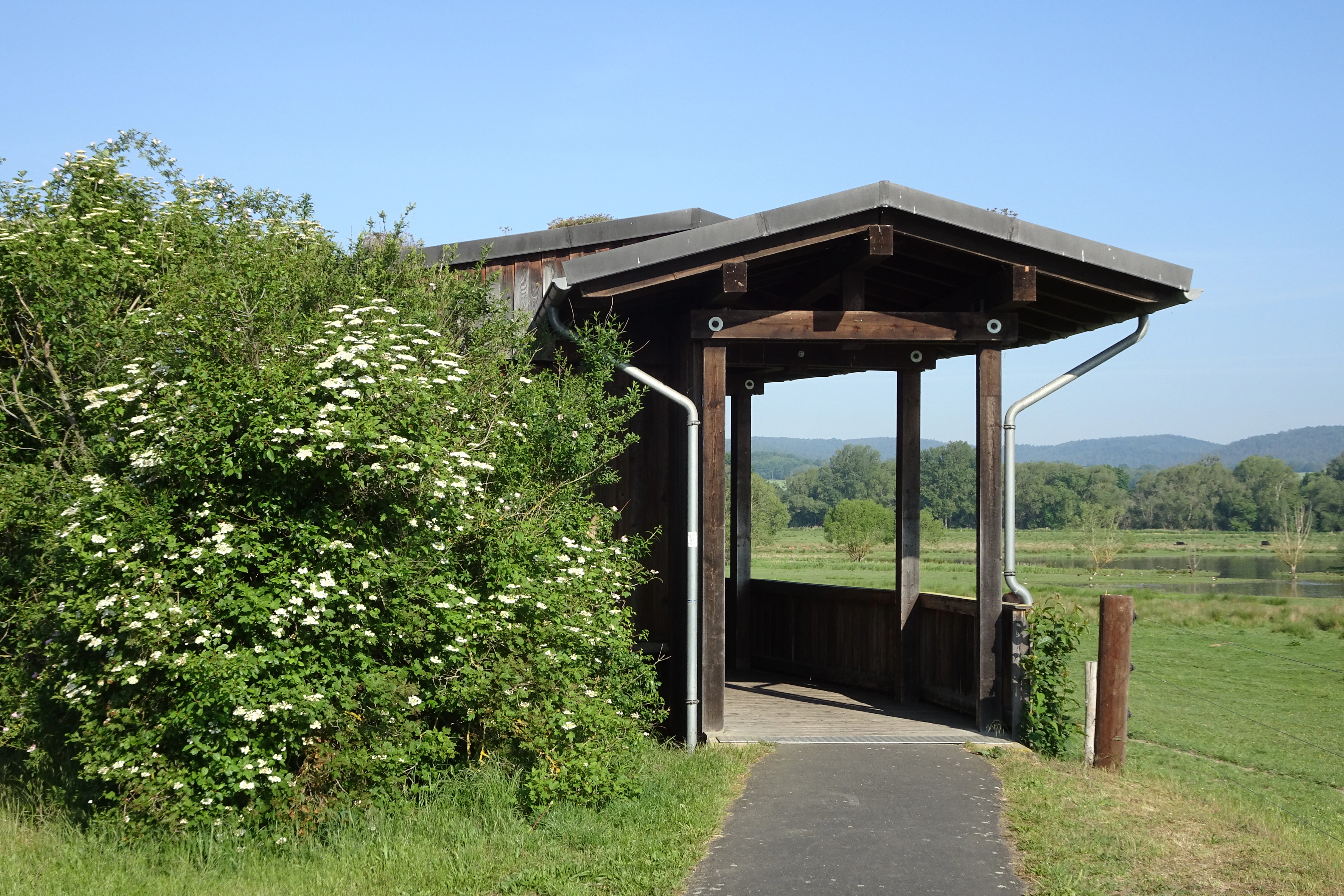
A wooden open-sided observation shelter stands on a paved path next to a large flowering shrub in a green meadow with distant hills in the background.
A wooden bird observation shelter at the Dankmarshäuser Rhäden nature area, providing views over the floodplain meadows.

Werra-Aue zwischen Breitungen und Creuzburg conservation status and protection priorities

Conservation significance in the Werra-Aue is layered rather than singular, with European, national, and regional designations stacked on top of one another to protect a continuous stretch of floodplain habitat. As a Special Protection Area under the EU Birds Directive, the site contributes directly to Natura 2000, the coordinated European network aimed at maintaining biological diversity and reversing long-term declines in wild species and their habitats. The Birds Directive and the EU Habitats Directive together form the legal backbone of this protection.

Domestically, twelve individual nature reserves overlap parts of the SPA, including Breitunger Seen, Forstloch and Riedwiesen, Erlensee and Maiwiesen, Karrenwiesen, Werraaue mit Altarmen bei Unterrohn, Brühl von Merkers, Schergesbachaue, Rohrlache zwischen Dippach und Dankmarshausen, Dankmarshäuser Rhäden, Werraaue bei Berka und Untersuhl, Alte Werra, and Wilhelmsglücksbrunn. Three FFH sites complement the bird-focused protections: the Werra river corridor up to Treffurt with its tributaries, the Breitunger Seen complex, and the Dankmarshäuser Rhäden wetland. Additional layers include floodplain protections and small natural monuments, and management is overseen by the Thüringer Landesamt für Umwelt, Bergbau und Naturschutz. Together these overlapping regimes aim to maintain the area's function as breeding, feeding, and resting habitat for a defined set of bird species, while also preserving habitats of broader European conservation interest.

Werra-Aue zwischen Breitungen und Creuzburg cultural meaning and human context

The Werra valley has long been an inhabited working landscape, where small towns, villages, and traditional land use have shaped the floodplain for centuries. Areas such as the Dankmarshäuser Rhäden still reflect this heritage through year-round grazing traditions that have, almost incidentally, maintained the open meadow structure that meadow-breeding birds depend on today. Small communities along the river, including Breitungen, Creuzburg, Werra-Suhl-Tal, and Bad Salzungen, are linked historically by the Werra as both a transport corridor and a cultural anchor, with the river providing identity as well as livelihood.

The Werratal-Radweg, a long-distance cycling route following the Werra from its sources in the Thuringian Slate Mountains to its confluence with the Fulda at Hann. Münden, runs directly through or alongside the protected area. This route integrates the floodplain into regional recreation and tourism, allowing visitors to experience it from its edges and through designated footpaths with bird observation hides and informational panels. Visitor guidance emphasizes quiet behavior and keeping dogs under control, reflecting an ethic of low-impact observation that aligns the area's cultural role with its conservation goals.

Top sights and standout views in Werra-Aue zwischen Breitungen und Creuzburg

Werra-Aue zwischen Breitungen und Creuzburg stands out for its unusually layered conservation profile: a single 2,578-hectare floodplain hosts a Special Protection Area under the EU Birds Directive, three overlapping FFH sites, twelve nature reserves, and additional floodplain protections. The geological fingerprint of the Permian salt deposits, which created the sinkhole lakes and old river arms, makes the landscape distinctive within central Germany.

For visitors and researchers, the area combines high bird species diversity with relatively easy access via the Werratal-Radweg and a small network of footpaths equipped with observation hides and informational panels. The combination of open water, reedbeds, wet meadows, and remnant floodplain woodland supports both breeding residents and large numbers of migratory waterbirds and waders, while traditional extensive grazing in places such as the Dankmarshäuser Rhäden maintains habitat openness through long-standing cultural practice rather than active intervention alone.

Best time to visit Werra-Aue zwischen Breitungen und Creuzburg

The Werra-Aue offers distinctive experiences across the seasons, and the timing of a visit strongly shapes what is visible. Spring and early summer are the most rewarding periods for birdwatchers, as meadow-breeding species such as Lapwing, Corncrake, and Bluethroat settle into their nesting territories on the wet meadows and along the reed-fringed old river arms. Migratory waterbirds, waders, and raptors often pass through or stage in the floodplain during the same months, adding to the birding interest.

Late summer and autumn tend to bring large flocks of geese, ducks, and other waterfowl that use the open water and meadows of the subsidence lakes and backwaters as resting and feeding habitat. Winter can also be productive, particularly when cold weather pushes additional species into the area, although wetland surfaces may freeze and snow can limit access on foot. For cycling along the Werratal-Radweg or quiet observation from the visitor paths, the warmer months generally provide the most comfortable conditions, though the muted colors and reduced disturbance of late autumn and winter can also be appealing for contemplative visits.

Monthly climate preview

Long-term representative point measurements tracking monthly temperature and precipitation cycles

Werra-Aue zwischen Breitungen und Creuzburg Climate Normals and Annual Weather Rhythm

Werra-Aue zwischen Breitungen und Creuzburg displays a recorded annual temperature progression from winter sub-zero minimums to summer maximums exceeding thirty degrees, alongside steady year-round precipitation rates. Examining the full twelve-month profile provides complete historical climate data and detailed monthly comparison metrics.
Annual mean8 °C
-1 °C18 °C
Jan-1°
Feb
Mar
Apr
May12°
Jun16°
Jul18°
Aug18°
Sep14°
Oct
Nov
Dec
Warmest month
July

18.3 °C

Coolest month
January

-1.1 °C

Wettest month
July

2.6 mm/day

Driest month
April

1.4 mm/day

Park location guide

Geography guide, regional context, and park location map for Werra-Aue zwischen Breitungen und Creuzburg

Werra-Aue zwischen Breitungen und Creuzburg park geography, regions, and map view in Germany

Understand where Werra-Aue zwischen Breitungen und Creuzburg sits in Germany through a broader geographic reading of the surrounding landscape, nearby location context, and its mapped position within the national park landscape.

How Werra-Aue zwischen Breitungen und Creuzburg fits into Germany

Germany is a federal republic in Western and Central Europe with a population of over 83 million across sixteen constituent states. It is Europe's largest economy by nominal GDP and a major global exporter and importer. The capital is Berlin, and the country borders Denmark, Poland, Czech Republic, Austria, Switzerland, France, Luxembourg, Belgium, and the Netherlands.

Wider geography shaping Werra-Aue zwischen Breitungen und Creuzburg in Germany

Germany is located in Western and Central Europe, spanning 357,022 km². It borders Denmark to the north, Poland and the Czech Republic to the east, Austria and Switzerland to the south, and France, Luxembourg, Belgium, and the Netherlands to the west. The country has coastlines on the Baltic Sea and North Sea to the north, with the Alps located in the southern region.

Map view of Werra-Aue zwischen Breitungen und Creuzburg

Use this park location map to pinpoint Werra-Aue zwischen Breitungen und Creuzburg in Germany, understand its exact geographic position, and read its mapped placement within the surrounding landscape more clearly.

Pigeon | © OpenStreetMap contributors

Location context for Werra-Aue zwischen Breitungen und Creuzburg

Thuringia
Recorded earthquake history

Explore Historical Earthquake Records for Werra-Aue zwischen Breitungen und Creuzburg

Consult the dedicated catalogue of seismic events documented near the Werra-Aue zwischen Breitungen und Creuzburg nature reserve. This resource provides historical context for ground motion data within the region, enabling users to examine individual event specifications without implying site-specific hazard assessments or future risk.

Werra-Aue Earthquake History

Catalogued events

6 events

Strongest magnitude

Magnitude 5.3

Most recent event

Oct 25, 2006

This history includes earthquakes recorded inside the park or within 50 km of its borders

Visual exploration of river valley habitats, sinkhole lakes, and floodplain scenery

Werra-Aue zwischen Breitungen und Creuzburg Photos and Protected Landscape Views

Visual documentation captures the complex terrain, open wet meadows, and quiet oxbow channels defining the protected river corridor. Detailed photographic records reveal the characteristic habitats and wetland scenery sustaining migratory waterbirds across the valley floor.

A peaceful landscape view of a green wetland meadow with a dark-colored cow standing near a pile of branches; white hawthorn blossoms hang in the foreground, and a calm body of water stretches into the misty background.

A group of four white storks walking through a vibrant green grassy field with a line of trees and a distant wind turbine in the background.

A large flock of geese swimming in a shallow, marshy wetland with golden-brown grasses and deciduous trees in the background under a blue sky.

A wide aerial view of a lush green river valley with open meadows, scattered trees, and several small ponds under a clear sky.

A wooden open-sided observation shelter stands on a paved path next to a large flowering shrub in a green meadow with distant hills in the background.

A wide view of a vibrant, flower-filled floodplain meadow with a line of trees in the distance under a bright sky.

Park atlas

Compare adjacent river valleys, regional wetlands, and connected European conservation areas

Other Parks Near Werra-Aue zwischen Breitungen und Creuzburg and Surrounding Protected Landscapes

Browse other protected areas near Werra-Aue zwischen Breitungen und Creuzburg to examine similar river valley ecosystems and floodplain habitats in the surrounding region. Comparing adjacent nature reserves and regional park geography provides deeper context into Thuringia conservation networks.
A horizontal watercolor illustration of a gentle, rolling landscape with green trees, meadow grass, and distant hills under a light blue sky.
Nature reserveWartburgkreis
Mapped location lies within the park boundary#1 closest

Southwest

Alte Werra Nature Reserve: Floodplain Geography and Protected Meadow Landscapes in Wartburgkreis

Essential river valley habitats and Natura 2000 protected areas.

Alte Werra serves as a critical protected landscape in the Wartburgkreis district of Germany. Centered on the Middle Werra valley, this 258 hectare nature reserve protects unique floodplain terrain including oxbow remnants, the Böllerteiche ponds, and diverse wet grassland habitats. The site remains a key reference point for studying riverine geomorphology and protected bird corridors in the Thuringia region.

Area
2.578 km²
Established
1996
IUCN
IV
Relief
Lowland
Nature reserveWartburgkreis
Mapped location lies within the park boundary#2 closest

South

Brühl von Merkers Nature Reserve: Floodplain Geography in the Wartburgkreis District

Protected Werra valley meadows and wetland ecosystems

Brühl von Merkers preserves a rare, open stretch of Werra river floodplain within Germany. This nature reserve offers a detailed look at extensively managed grasslands and wetland habitats that support avian populations and maintain regional ecological integrity within the Wartburgkreis administrative area.

Area
1.756 km²
Established
2014
IUCN
IV
A soft watercolor illustration of a calm pond surrounded by green vegetation and rolling hills in the background.
Nature reserveWartburgkreis
Park boundaries overlap#3 closest

Southwest

Dankmarshäuser Rhäden: Protected Wetland Reserve and Mapped Floodplain in Wartburgkreis

Restored basin landscape along the historic Green Belt corridor.

Dankmarshäuser Rhäden comprises a complex wetland mosaic in the Wartburgkreis district. This nature reserve, characterized by shallow subsidence basins and active floodplain management, represents a critical migratory bird sanctuary and a key component of the protected Green Belt. The area reveals a history of land-use transition, from agricultural depression to a functional, water-managed ecosystem supporting diverse meadow-nesting and migratory bird populations.

Area
1.217 km²
Established
1995
IUCN
IV
Nature reserveWartburgkreis
Mapped location lies within the park boundary#4 closest

South

Erlensee - Maiwiesen Nature Reserve and Werra Floodplain Protected Landscape

A vital wetland and meadow network in Wartburgkreis, Germany

Erlensee - Maiwiesen represents an important nature reserve in the Wartburgkreis district of Germany, characterized by the pairing of an alder-fringed lake with extensive wet meadows. This area plays a significant role in the regional Werra biotope network, focusing on the preservation of riverine habitats and lowland grassland biodiversity within a settled landscape. The site serves as a prime example of active habitat management and floodplain connectivity.

Area
1.089 km²
Established
2018
IUCN
IV
A soft watercolor illustration of a wetland landscape featuring trees, green grasses, a small pond, and distant rolling hills against a pale pink sky.
Nature reserveHesse
Park boundaries overlap#5 closest

Southwest

Obersuhler Aue Protected Meadow Complex and Werra Valley Geographic Mapping

Expansive floodplain ecosystems and conservation corridors in Hesse

Obersuhler Aue comprises a vital lowland meadow system that spans the Werra valley floor. The area is characterized by its open, unfragmented grassland terrain, which serves as a landmark site for biodiversity within the Hessian Green Belt. From historic linden avenues to seasonally flooded reedbeds, the landscape provides essential habitat continuity across the regional basin.

Area
0.679 km²
Established
1990
IUCN
IV
A soft watercolor illustration depicting a flat green wetland landscape with a winding river and distant rolling hills under a pale sky.
Nature reserveHesse
Park boundaries overlap#6 closest

Southwest

Rhäden bei Obersuhl und Bosserode: Nature Reserve and Wetland Mosaic in Northern Hesse

A restored floodplain landscape in the Werra valley

Rhäden bei Obersuhl und Bosserode represents a significant subsidence basin restored from agricultural land into a thriving wetland. This protected nature reserve in Hesse features a structured mosaic of ponds, reedbeds, and wet meadows, serving as a primary regional site for bird migration and habitat conservation within the Werra valley geography.

Area
1.204 km²
Established
1973
IUCN
IV
Relief
Lowland
Nature reserveThuringia
Park boundaries overlap#7 closest

Southeast

Werra bis Treffurt mit Zuflüssen: Protected River and Floodplain Network in Thuringia

Mapping an extensive 191 kilometer Natura 2000 river corridor.

The Werra bis Treffurt mit Zuflüssen protected area serves as a vital ecological corridor in Thuringia. This site encompasses a complex mosaic of fast-flowing highland brooks, expansive floodplain meadows, inland salt sites, and rare dissolution lakes. Its geography bridges high-altitude source regions with lower river valleys, creating a distinctive landscape transect that supports essential freshwater habitats and rare aquatic species across the state.

Area
22.6 km²
Established
2008
IUCN
IV
Relief
Mixed relief
Nature reserveWartburgkreis
Mapped location lies within the park boundary#8 closest

Southwest

Werraaue bei Berka und Untersuhl: Protected Floodplain and Wetland Geography in Wartburgkreis

Mapped riverine habitat and regional conservation area

Located in the heart of the Berka basin, this nature reserve protects a diverse floodplain environment featuring rare inland saline habitats and intricate oxbow lake systems. Serving as a vital ecological stepping stone along the former inner-German border, it represents one of the most important meadow bird corridors within the Wartburgkreis district.

Area
2.558 km²
Established
1996
IUCN
IV
Relief
Lowland

Common questions about visiting, size, designation, and location context for Werra-Aue zwischen Breitungen und Creuzburg

Werra-Aue zwischen Breitungen und Creuzburg FAQs for park facts, access, geography, and protected area context

Find quick answers about Werra-Aue zwischen Breitungen und Creuzburg, including protected-area facts, park geography, trail and visitor context, and how the park fits into its surrounding country and regional landscape.
MoriAtlas Explorer

Continue Your Protected Areas Search Across the Global Atlas

Deepen your exploration by continuing the structured search for national parks and protected areas worldwide. Utilize the comprehensive filtering capabilities to compare different conservation landscapes and refine your understanding of global park geography. Discover more about the distribution and characteristics of protected natural areas.

Global natural geography