Why West of Walney Marine Conservation Zone stands out
West of Walney is best known for being a large Marine Conservation Zone formed around subtidal mud and sand habitats in the Irish Sea, and for the unusual way its protection is reinforced by its location within an offshore wind farm. The combination of a substantial protected seabed area and co-location with operational wind turbines makes the site stand out among England's Marine Conservation Zones. It is also recognized for sea pens and other fauna associated with soft sediment habitats.
West of Walney Marine Conservation Zone history and protected-area timeline
West of Walney was formally designated as a Marine Conservation Zone in 2016. Its creation was part of a broader programme of Marine Conservation Zone designations around the English coast during that period, and at the time of designation it was one of three MCZs off the Cumbrian coast, alongside Allonby Bay and the Cumbria Coast.
From the outset, the site's history has been closely tied to the presence of offshore wind turbines in the same area. The overlap between the MCZ and the existing wind farm simplified the practical task of restricting bottom trawling, because trawling was already generally discouraged within the wind farm footprint. This meant that protection from damaging forms of fishing could be introduced more readily than in many purely marine zones without such infrastructure.
In 2019, this approach was formalised when a byelaw prohibited bottom trawling across the majority of the West of Walney site. Following this, trials of creel-based prawn fishing were carried out within the zone to explore more sustainable fishing methods compatible with the protected status of the seabed. The site's history therefore reflects a transition from designation through active management to experimentation with sustainable fisheries within a protected marine environment.
West of Walney Marine Conservation Zone landscape and geographic character
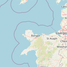
West of Walney is a marine rather than terrestrial site, so its landscape is defined by the seabed it protects rather than by landforms visible above the waterline. The zone lies in the Irish Sea, west of Walney Island and off the southern edge of the Cumbrian coast in northwest England. Its horizontal footprint is substantial, covering roughly 388 square kilometres of sea, a scale comparable to the Isle of Wight, even though it has no terrestrial surface of its own.
The seabed environment of the site consists primarily of subtidal mud and subtidal sand. These are soft, sediment-dominated habitats that occur in conditions where finer particulates settle on the seafloor. The water depths across the zone range from around 15 metres to around 33 metres, placing the site within the shallower subtidal band rather than in the deeper parts of the Irish Sea basin. This depth profile, combined with the sediment character, gives the area a relatively uniform seabed landscape that is nonetheless ecologically distinctive.
Above the seabed, the visible seascape is shaped by the presence of offshore wind turbines that stand within the conservation zone. The combination of open sea, a soft sediment seabed, and energy infrastructure punctuating the horizon has become the defining visual and functional landscape of West of Walney.
West of Walney Marine Conservation Zone ecosystems, habitats, and plant life
The ecological character of West of Walney centres on subtidal soft sediment habitats. Subtidal mud and subtidal sand environments are widespread in the Irish Sea and are recognised for supporting communities of burrowing and sediment-associated invertebrates, which in turn underpin wider food webs in surrounding waters. The protected nature of the zone is intended to allow these communities to persist with reduced pressure from bottom-disturbing fishing activities.
The site's ecological profile is closely linked to its setting in the eastern Irish Sea, where mixed sediments and soft sediments form mosaics across relatively shallow waters. By safeguarding a continuous area of these habitats, the MCZ contributes to ecological connectivity and to the representation of subtidal sediment communities within the regional network of marine protection around England. The combination of protected sediments and restricted trawling creates conditions in which the structure of the seabed and its resident fauna can remain comparatively undisturbed.
While West of Walney is dominated by soft sediment habitats, the marine environment of the wider area is dynamic, with tidal flows and sediment movement shaping how the seabed communities develop over time. The site's ecological significance lies as much in the scale of the protected area and the reduced disturbance regime as in any single species or habitat type.
West of Walney Marine Conservation Zone wildlife and species highlights
The wildlife interest of West of Walney is typical of subtidal soft sediment environments in the eastern Irish Sea. Fauna associated with the site includes sea pens, a group of colonial marine invertebrates that anchor into soft sediment and extend their polyps into the water column. Sea pens are recognised indicators of relatively undisturbed subtidal mud and sand habitats, which is consistent with the conservation aims of the MCZ.
The wider fauna of the area is expected to include the broader community of invertebrates and other animals linked to Irish Sea soft sediments, including burrowing species that live within the mud and sand, scavengers and predators that move across the seabed, and seasonal visitors that pass through the area as part of wider marine movements in the Irish Sea. Because detailed species inventories are not the focus of the available sources, the wildlife profile of the site is best understood through its habitat associations rather than through a full species list.
The protection offered to the seabed, combined with restrictions on bottom trawling across most of the zone, provides a backdrop against which the wildlife value of the area can develop. The site's role as a trial area for creel-based prawn fishing also reflects an interest in interactions between fishing activity and wildlife, where more selective methods are intended to reduce seabed disturbance while still allowing some harvest of commercially relevant species.
West of Walney Marine Conservation Zone conservation status and protection priorities
West of Walney was designated as a Marine Conservation Zone to protect subtidal mud and subtidal sand habitats in the Irish Sea. Its conservation purpose is to safeguard representative examples of these soft sediment habitats within the network of English MCZs, ensuring that they remain in a relatively undisturbed condition despite the range of human activities taking place around them.
The site's conservation significance is reinforced by its considerable size, at around 388 square kilometres, which gives it meaningful scale as a protected marine area and supports ecological functions across a broad area of seabed. The combination of subtidal mud and subtidal sand within a single zone also adds value, allowing the conservation of related sediment-based communities in a connected setting within the eastern Irish Sea.
A distinctive aspect of West of Walney's conservation approach is its reliance on co-location with offshore wind infrastructure to deliver protection from bottom trawling. With trawling already discouraged within the wind farm, the introduction of a byelaw in 2019 prohibiting bottom trawling across most of the site formalised and extended this protection. The site has also been used to trial creel-based prawn fishing, exploring how sustainable fishing methods can operate within a protected marine zone. Together these features make West of Walney an example of coordinated conservation, renewable energy, and fisheries management within a single marine area.
West of Walney Marine Conservation Zone cultural meaning and human context
Walney Island, the landfall nearest to the Marine Conservation Zone, has a long history as a coastal community off the Cumbrian coast, with livelihoods traditionally linked to the surrounding waters of the eastern Irish Sea. The waters west of Walney have historically been part of the working seascape of the region, used for fishing and, more recently, for offshore energy generation.
The cultural context of the site today reflects the intersection of these traditional uses with newer marine industries. The presence of offshore wind turbines alongside the conservation zone marks the area as a place where renewable energy development and environmental protection have been deliberately accommodated together. Trials of creel-based prawn fishing within the MCZ also point to an evolving relationship between local fishing practices and the regulatory frameworks governing the seabed, as the community and industry adapt to new management arrangements.
Top sights and standout views in West of Walney Marine Conservation Zone
The highlights of West of Walney centre on a few distinctive features. The first is the sheer scale of the protected area: at around 388 square kilometres, the MCZ covers a substantial portion of the eastern Irish Sea west of Walney Island, with seabed habitats of subtidal mud and subtidal sand.
The second is the unusually close relationship between conservation and renewable energy. West of Walney is co-located with offshore wind turbines, and this overlap has made it easier to limit bottom trawling across most of the zone, a protection that was formalised through a 2019 byelaw. As one of three Marine Conservation Zones off the Cumbrian coast, alongside Allonby Bay and Cumbria Coast, West of Walney also forms part of a wider regional network of marine protection, while trials of creel-based prawn fishing hint at more sustainable fisheries approaches within its boundaries.
Best time to visit West of Walney Marine Conservation Zone
West of Walney is a marine site without inland access points or formal visitor facilities, and the available sources do not describe visitor logistics. Most engagement with the site would be through boat-based trips, wildlife cruises, or viewing from coastal points on Walney Island and the southern Cumbrian coast. Because the protected area is defined by seabed habitats rather than seasonal events on land, seasonality mainly affects surface conditions such as sea state, daylight hours, and wildlife viewing opportunities, while the seabed habitats themselves are present year round.