
Mori Atlas logo
Nature reserveWölferlinger Weiher

Examining the geographic boundaries and wetland terrain of this historic Westerwald pond system

Wölferlinger Weiher Nature Reserve: Protected Wetland Landscape in Westerwaldkreis, Germany

Wölferlinger Weiher stands as an ecologically significant nature reserve within the Westerwaldkreis district of Rhineland-Palatinate. This detail page tracks the mapped boundaries and wetland terrain of the smallest pond in the historic Westerwälder Seenplatte, providing a clear geographic overview of its marshes, wet meadows, and aquatic features that define this protected environment.

nature reservewetlandpondNaturschutzgebietWesterwaldRhineland-Palatinate
A digital illustration of a scenic valley featuring tall cliffs, a cascading waterfall, a winding river, and surrounding forest vegetation.

Wölferlinger Weiher

Nature reserve

Park overview

Structured park overview, official facts, and landscape profile for Wölferlinger Weiher

Wölferlinger Weiher park facts, protected area profile, and essential visitor context

Review the core facts for Wölferlinger Weiher, including designation, size, terrain, visitor scale, habitats, and operating context in one park-focused overview.

About Wölferlinger Weiher

Wölferlinger Weiher is a small but ecologically rich wetland located in the eastern part of the Westerwald, a low-mountain region in Rhineland-Palatinate, western Germany. Its setting between the villages of Wölferlingen and Langenhahn places it within the broader Westerwälder Seenplatte, a landscape protection area defined by a chain of ponds whose origins go back to the seventeenth century.

At roughly 1.02 hectares, the pond is the smallest of the seven waters that make up this historic group. Despite its modest size, it is the focal point of a much larger nature reserve of about 90 hectares, in which the open water is buffered by reed beds, transitional marsh, shallow-water zones, and wet meadows. These habitats together form a coherent wetland complex that has clear conservation value in a region otherwise dominated by forests, farmland, and dispersed villages.

Legal protection has applied since 1979, when the Bezirksregierung Koblenz passed a formal ordinance recognizing the area's importance for rare flora and threatened fauna. In 2019, ownership of the pond and its companion waters passed to the NABU-Stiftung Nationales Naturerbe, anchoring the site's future management within the framework of national natural heritage stewardship. The pond also lies along the 7-Weiher-Weg, a hiking route that links the historic Westerwald ponds and frames the area as a quiet destination for those interested in wetland landscapes, birdwatching, and botany.

Quick facts and research context for Wölferlinger Weiher

Wölferlinger Weiher is a nature reserve located in the Westerwald region of Rhineland-Palatinate, within the Westerwaldkreis district. The site has been officially protected since 1979 when the Bezirksregierung Koblenz issued its conservation ordinance.

The waterbody is about 1.02 hectares in area, making it the smallest of the seven ponds that together form the Westerwälder Seenplatte landscape protection area. The broader reserve totals approximately 90 hectares, encompassing pond, marsh, shallow-water, and wet meadow habitats. Since 2019, the pond and its companion waters are owned by the NABU-Stiftung Nationales Naturerbe.

Protection and recognition

Explore verified protection status, management scope, and international recognition records

Wölferlinger Weiher Protection Status and Documented Conservation Scope

Terrestrial protection records for Wölferlinger Weiher outline official conservation status and administrative designation history. Structured database metrics aggregate verified management scope and international recognition data for natural area research.

Protection details

Protection scope
Terrestrial
Transboundary protection
No
WDPA ID
82936
Park context

Deeper park guide and search-rich context for Wölferlinger Weiher

Wölferlinger Weiher history, landscape, wildlife, and travel context

Explore Wölferlinger Weiher through its history, landscape character, ecosystems, wildlife, conservation priorities, cultural context, and seasonal travel timing in a structured park guide built for atlas discovery and search intent.

Why Wölferlinger Weiher stands out

The site is primarily known for its small, ecologically rich pond surrounded by marshland and shallow-water zones that shelter rare plant and bird species. It is also notable as the smallest member of the Westerwälder Seenplatte, a group of historic seventeenth-century ponds laid out under Count Friedrich III zu Wied. The reserve's protected species, including the Blue Sky Vine (Blaue Himmelsleiter) and the Two-leaved Forest Hyacinth (Zweiblättrige Waldhyazinthe), give it a botanical profile that stands out within the regional network of protected waters.
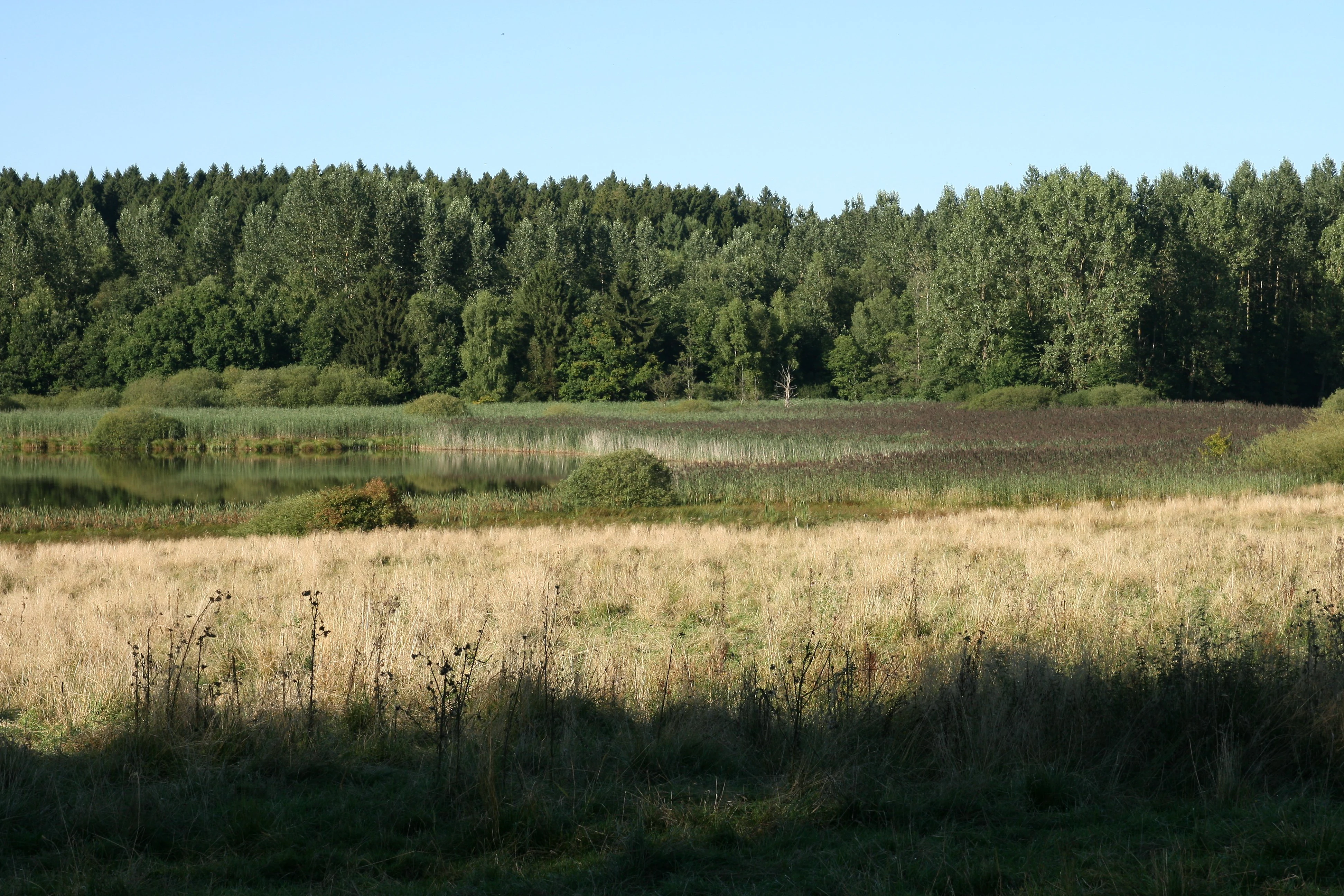
A landscape view of the Wölferlinger Weiher nature reserve featuring a golden grassy meadow in the foreground, wetland vegetation, and a dense forest in the background under a clear sky.
A view of the wetland habitat at Wölferlinger Weiher nature reserve.

Wölferlinger Weiher history and protected-area timeline

The ponds of the Westerwälder Seenplatte, including Wölferlinger Weiher, were originally created in the seventeenth century under Count Friedrich III zu Wied. Their construction established a chain of small impoundments that were used as fishing waters and landscape features and that have shaped the character of the region ever since.

For most of their history, these waters were managed as part of regional land use rather than as strictly protected natural assets. The ecological value of Wölferlinger Weiher became formally recognized only in the late twentieth century. On 20 January 1979, the Bezirksregierung Koblenz issued a legal ordinance designating the area around the pond as an official nature reserve (Naturschutzgebiet), establishing protective status that continues to apply today.

A second turning point came in 2019, when the pond was transferred along with the other Westerwälder Seenplatte waters into the ownership of the NABU-Stiftung Nationales Naturerbe. This step placed the long-term stewardship of the site in the hands of a national conservation foundation and reinforced its status as part of Germany's recognized natural heritage.

Wölferlinger Weiher landscape and geographic character

The landscape of Wölferlinger Weiher is defined by a small still-water pond set within a gently rolling stretch of the Westerwald. The water surface sits at about 429 meters above sea level and is framed by soft slopes rather than dramatic relief, which gives the site an intimate, enclosed character.

Around the pond, the terrain transitions into reed-covered edges, shallow-water margins, and patches of marsh where standing water and saturated ground support wetland vegetation. Beyond these fringes, the reserve extends into wet meadows and moist grassland that gradually blend into the surrounding forests and farmland typical of the Westerwald. The whole system reads as a small but well-structured wetland mosaic embedded in an otherwise mixed rural landscape.

The pond drains via the Saynbach, linking this small waterbody into the broader hydrology of the Sayn river system and reinforcing its landscape role within the Westerwälder Seenplatte as a whole.

Wölferlinger Weiher ecosystems, habitats, and plant life

Ecologically, Wölferlinger Weiher represents a classic example of a small, structurally diverse low-mountain wetland. The combination of open water, emergent reed vegetation, shallow littoral zones, and surrounding wet grassland creates a gradient of moisture conditions within a compact area, supporting a disproportionately high variety of species relative to its size.

The pond's waters are fringed with reed growth, visible especially along the eastern shore, where dense stands of tall marsh plants rise directly from the water. Flachwasserzonen and Sumpfflächen, or shallow-water and genuine swamp zones, expand the wetland interface and offer habitats that many specialized wetland species depend on. Beyond these wet zones, the ordinance-protected area continues into adjoining moist grassland, maintaining a continuous moist-soil environment from open water to meadow.

The reserve's ecological significance is recognized in its 1979 protection ordinance, which explicitly cites the scientific value of the site as habitat for rare plant species and as a refuge for threatened fauna, in particular rare bird species. This combination of open water, marsh, and wet meadow within a relatively small footprint is what gives the reserve a meaningful ecological identity.

Wölferlinger Weiher wildlife and species highlights

The wildlife significance of Wölferlinger Weiher lies primarily in the birdlife that uses its mix of open water, reedbeds, and surrounding meadows. Its protected status formally acknowledges the site as a refuge for rare and threatened bird species, and the mosaic of habitats supports breeding, feeding, and resting conditions for wetland-dependent species.

The shallow margins and standing water also provide habitat for amphibians, aquatic invertebrates, and other fauna typical of low-mountain wetland environments. Although the reserve is small, the structural diversity of its habitats means that its fauna profile is more varied than the simple pond area would suggest.

The 1979 protection ordinance specifically cites the conservation of rare bird species and threatened animal species as a central aim of the reserve, which underlines the site's particular value for birdwatchers and for ornithological research in the Westerwald region.

Wölferlinger Weiher conservation status and protection priorities

Wölferlinger Weiher has been under formal nature protection since 1979, when the Bezirksregierung Koblenz issued a dedicated ordinance defining its Schutz schweck. The stated purpose of the designation is the preservation of the wetland system as a whole: its open water surfaces, shallow-water zones, marsh areas, and the adjoining wet grassland that together form a coherent moist-soil complex.

The ordinance identifies two principal conservation goals. The first is to preserve the area as a location for rare plant species, many of which depend on the specific hydrological and soil conditions created by the pond and its surroundings. The second is to maintain it as a habitat for threatened and rare fauna, especially rare bird species, with the conservation rationale explicitly citing scientific reasons. This framing positions the reserve as a site of recognized scientific and ecological importance rather than merely a locally protected pond.

In 2019, ownership of the pond together with the other Westerwälder Seenplatte waters was transferred to the NABU-Stiftung Nationales Naturerbe, a national natural-heritage foundation. This ownership change embedded the site within a structured conservation framework and strengthened the long-term protection of the wetland against future land-use changes. The reserve is also listed in international databases such as the World Database on Protected Areas, indicating its recognition beyond the regional level.

Wölferlinger Weiher cultural meaning and human context

The cultural context of Wölferlinger Weiher is closely tied to the long history of the Westerwälder Seenplatte. The ponds that make up this group, including Wölferlinger Weiher, were created in the seventeenth century under Count Friedrich III zu Wied, giving the surrounding landscape a heritage shaped by early modern land management and aristocratic stewardship.

This origin gives the network of ponds a recognizable historical dimension, in which still waters originally built for practical use have become elements of regional identity and, in time, of conservation value. The integration of the pond into the 7-Weiher-Weg hiking route today reflects this continuing role, connecting natural heritage with traditional landscape appreciation.

Top sights and standout views in Wölferlinger Weiher

Wölferlinger Weiher stands out as the smallest but ecologically distinctive member of the Westerwälder Seenplatte, a chain of seventeenth-century ponds in the Westerwald region of Rhineland-Palatinate. Its protected wetlands shelter rare plant species such as the Blue Sky Vine and the Two-leaved Forest Hyacinth, and its combination of open water, reed fringes, marsh, and wet meadow creates a habitat mosaic that punches above its modest size.

Under NABU-Stiftung ownership since 2019 and protected under a 1979 ordinance that explicitly cites scientific and species-conservation reasons, the reserve occupies a meaningful place in the regional network of protected areas of the Westerwaldkreis.

Best time to visit Wölferlinger Weiher

The pond and its wetland surroundings are most atmospheric in the warmer months, when reed and marsh vegetation is at its fullest and bird activity around the wetland is at its peak. Late spring and early summer typically bring the most active breeding bird behavior and the richest display of wetland plants in the shallow-water and meadow zones.

Autumn visits can also be rewarding, with quieter conditions, mature reed stands, and visible migratory bird movement in the wider Westerwald landscape. Winter visits are possible but tend to emphasize the broader forest and meadow setting rather than the wetland's full biological character.

Monthly climate preview

Long-term temperature and precipitation patterns across the representative coordinate

Wölferlinger Weiher Climate Normals and Annual Weather by Month

Historical data records monthly temperature swings from sub-zero winter minimums to warm summer maximums alongside consistent daily precipitation averages. Examining the complete twelve-month climatology profile reveals deeper multi-year environmental rhythms for Wölferlinger Weiher.
Annual mean9 °C
0 °C19 °C
Jan
Feb
Mar
Apr
May12°
Jun16°
Jul19°
Aug18°
Sep14°
Oct
Nov
Dec
Warmest month
July

18.5 °C

Coolest month
January

-0.4 °C

Wettest month
December

2.5 mm/day

Driest month
April

1.6 mm/day

Park location guide

Geography guide, regional context, and park location map for Wölferlinger Weiher

Wölferlinger Weiher park geography, regions, and map view in Germany

Understand where Wölferlinger Weiher sits in Germany through a broader geographic reading of the surrounding landscape, nearby location context, and its mapped position within the national park landscape.

How Wölferlinger Weiher fits into Germany

Germany is a federal republic in Western and Central Europe with a population of over 83 million across sixteen constituent states. It is Europe's largest economy by nominal GDP and a major global exporter and importer. The capital is Berlin, and the country borders Denmark, Poland, Czech Republic, Austria, Switzerland, France, Luxembourg, Belgium, and the Netherlands.

Wider geography shaping Wölferlinger Weiher in Germany

Germany is located in Western and Central Europe, spanning 357,022 km². It borders Denmark to the north, Poland and the Czech Republic to the east, Austria and Switzerland to the south, and France, Luxembourg, Belgium, and the Netherlands to the west. The country has coastlines on the Baltic Sea and North Sea to the north, with the Alps located in the southern region.

Map view of Wölferlinger Weiher

Use this park location map to pinpoint Wölferlinger Weiher in Germany, understand its exact geographic position, and read its mapped placement within the surrounding landscape more clearly.

Pigeon | © OpenStreetMap contributors

Location context for Wölferlinger Weiher

Westerwaldkreis

Visual exploration of wetland habitats, shallow waters, and regional terrain

Wölferlinger Weiher Photos and Protected Landscape Scenery

Visual records capture the intimate pond environment, marshy fringes, and reed-covered edges defining Wölferlinger Weiher. Photographic documentation reveals the nuanced topography and protected wetland habitats characteristic of the Westerwald region.

A landscape view of the Wölferlinger Weiher nature reserve featuring a golden grassy meadow in the foreground, wetland vegetation, and a dense forest in the background under a clear sky.

A wide, eye level landscape view of a nature reserve featuring a grassy, golden-hued foreground, a marshy middle ground with bushes, and a dense, dark green forest in the background under a clear blue sky.

Park atlas

Compare nearby wetland reserves and connected regional waterways across the Westerwald

Other Parks Near Wölferlinger Weiher and Protected Landscapes to Explore

Visitors comparing Wölferlinger Weiher can browse adjacent nature reserves and protected wetland habitats throughout the surrounding district. Examining neighboring conservation areas reveals broader ecological patterns across the historic Westerwald pond network.
Nature reserveRheinland-Pfalz
About 2.6 km away#1 closest

Northwest

Westerwälder Seen: Nature Reserve Geography and Mapped Pond Landscape in Rhineland-Palatinate

Historic reservoir systems, wetland habitats, and upland plateau terrain

Westerwälder Seen is a sprawling nature reserve defined by its system of seven interconnected, man-made ponds and surrounding wetland fringes. Located in the heart of the Westerwald in Rhineland-Palatinate, this site serves as a prime example of historical land management evolving into a vital ecological refuge for waterbirds, amphibians, and diverse brook forest communities.

Area
2.28 km²
Established
1650
Relief
Upland
Climate
Temperate
A horizontal watercolor painting showing a calm lake or pond with grassy banks, small trees, and soft hills in the background.
Protected areaGermany
About 3.7 km away#2 closest

West

Brinkenweiher Protected Area and Westerwald Lake District Geography

Historic wetland habitat in Rhineland-Palatinate

Brinkenweiher serves as a significant example of a seventeenth-century Waldweiher, shaped by human engineering to dam the Holzbach headwaters. Today, the site functions as a protected nature reserve, offering a varied landscape of shadowed forest fringes, marshy wetlands, and open meadows that support a coherent wetland ecosystem within the broader Westerwälder Seenplatte.

Area
0.21 km²
Established
1660
Relief
Lowland
Scope
Terrestrial
A soft watercolor painting of a wide, flat landscape with a winding stream and light green hills under a hazy sky.
Nature reserveRhineland-Palatinate
About 4 km away#3 closest

Northwest

Dreifelder Weiher Nature Reserve and Westerwälder Seenplatte Protected Geography

A historic pond ecosystem in the northern Westerwald highlands

Spanning 123 hectares, Dreifelder Weiher serves as a vital nature reserve within the Rhenish Massif. Its shallow basin and seasonal drawdown cycles sustain a diverse landscape of reedbelts and marshes, reflecting the deep integration of German noble history and contemporary habitat protection.

Area
1.23 km²
Established
1668
Relief
Lowland
Climate
Temperate
A soft, light watercolor painting of rolling green hills, scattered trees, and a winding path under a pale, warm sky.
Nature reserveWesterwaldkreis
About 9.3 km away#4 closest

South

Naturschutzgebiet Malberg: Geography and Protected Phonolite Landscapes in Westerwaldkreis

Geological exploration of a unique volcanic nature reserve

Naturschutzgebiet Malberg provides a focused look at a rare volcanic cupola in Germany. Centered on a 22-million-year-old phonolite summit, the reserve protects a complex environment of blockfields, craggy crevices, and natural rock caves that stand out as a sharp geographic anomaly amidst the gentle lowlands of the Montabaur Basin.

Area
0.96 km²
Established
1971
IUCN
IV
Relief
Mountain
Watercolor illustration of a winding stream flowing through a lush green valley with rolling hills in the background.
Nature reserveRheinland-Pfalz
About 11 km away#5 closest

East

Holzbachdurchbruch: Basalt Gorge and Protected Nature Reserve in the Westerwald Highlands

Geological landscapes and protected stream valleys in Rheinland-Pfalz.

The Holzbachdurchbruch nature reserve is a focused, high-relief landscape defined by its classic breakthrough valley where the Holzbach cuts through resistant basalt bedrock. This protected area offers a look at the volcanic terrain and forest-stream mosaics that define the Westerwald, serving as a landmark site for understanding the regional geography and geological heritage of Germany.

Area
0.21 km²
Established
1961
IUCN
IV
Relief
Upland
A horizontal watercolor painting depicting a soft, scenic landscape of a park with rolling hills, a central body of water, and surrounding trees.
Nature reserveWesterwaldkreis
About 12 km away#6 closest

Northeast

Bacher Lay Nature Reserve: Basalt Quarry Landscapes in Westerwaldkreis, Germany

Protected landscape with significant geological geotope features

Bacher Lay provides an informative look at a compact nature reserve formed within a former basalt quarry. Featuring the striking Pfaffenmal columnar basalt formation and a mosaic of river valley habitats, the site serves as a vital protected area in the Westerwaldkreis region for studying habitat succession and geological formations.

Area
0.447 km²
Established
1996
IUCN
IV
Relief
Upland
Watercolor painting of a soft, hazy landscape featuring rolling green hills, distant mountains, and water in the foreground.
Nature reserveWesterwaldkreis
About 17 km away#7 closest

Northeast

Breitenbachtalsperre Nature Reserve: Geography and Protected Habitat Mapping in Westerwaldkreis

Managed wetland and reservoir landscape in western Germany

Breitenbachtalsperre protects an important reservoir ecosystem, including shallow margins and wet meadows near Waigandshain. This nature reserve provides a focused look at habitat management in the Westerwald, where stream-fed waters sustain diverse plant societies and wildlife in a compact, protected basin.

Area
0.47 km²
Established
1988
IUCN
IV
Nature reserveRheinland-Pfalz
About 17 km away#8 closest

East

Wacholderheide bei Westernohe Nature Reserve Protected Area Atlas and Geographic Map Context

Juniper heathland mosaic in the German Westerwald region

Spanning 14 hectares, Wacholderheide bei Westernohe acts as a vital protected pocket of open heathland framed by dense spruce forests. The reserve supports a specialized community of arnica, common heather, and juniper, sustained by decades of consistent grazing and mechanical mowing that define its unique regional character.

Area
0.14 km²
Established
1967
IUCN
IV

Common questions about visiting, size, designation, and location context for Wölferlinger Weiher

Wölferlinger Weiher FAQs for park facts, access, geography, and protected area context

Find quick answers about Wölferlinger Weiher, including protected-area facts, park geography, trail and visitor context, and how the park fits into its surrounding country and regional landscape.
MoriAtlas Explorer

Continue Your Protected Areas Search Across the Global Atlas

Deepen your exploration by continuing the structured search for national parks and protected areas worldwide. Utilize the comprehensive filtering capabilities to compare different conservation landscapes and refine your understanding of global park geography. Discover more about the distribution and characteristics of protected natural areas.

Global natural geography