
Mori Atlas logo
Protected landscapeZaufensgraben

A rare natural corridor and geological site defining the local Thuringian stream geography

Zaufensgraben Protected Landscape: Mapping the Steep Valley Terrain of Gera in Thuringia

(Landschaftsschutzgebiet Zaufensgraben)

Zaufensgraben represents a distinctive protected landscape within the city limits of Gera, Thuringia, characterized by its narrow, steep-sided valley and older willow stands. This protected corridor captures a unique interaction between Zechstein geological formations and a sharp, three-kilometer stream gradient. Mapping this area reveals a vital natural incision that stands in stark contrast to its surrounding urbanized landscape.

stream valleylandscape protection areaurban natureThuringiaGeraWillow stands
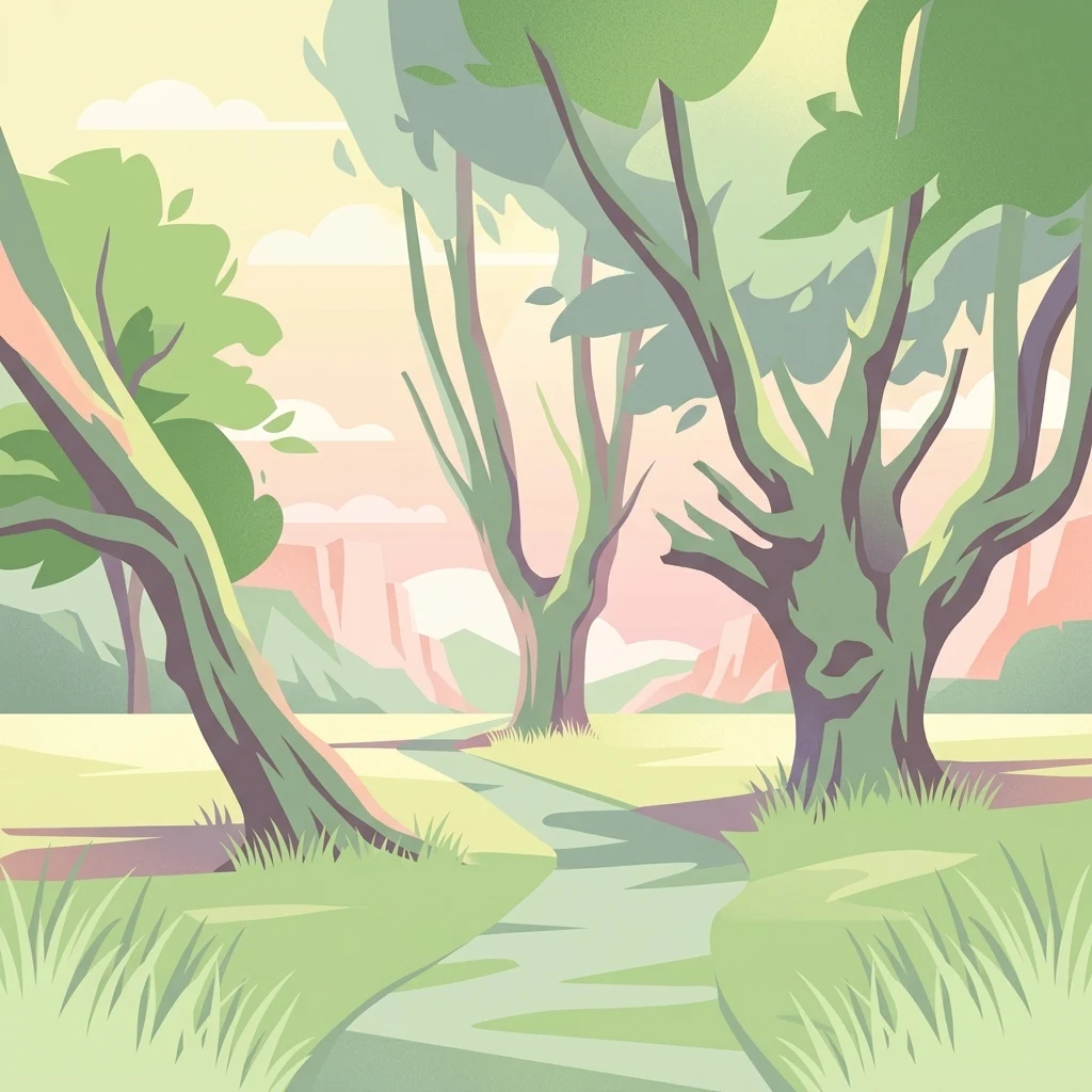
A stylized digital illustration of a green, sunlit valley with thick-trunked willow trees and a winding path leading toward distant hills.

Zaufensgraben

Protected landscape

Park overview

Structured park overview, official facts, and landscape profile for Zaufensgraben

Zaufensgraben park facts, protected area profile, and essential visitor context

Review the core facts for Zaufensgraben, including designation, size, terrain, visitor scale, habitats, and operating context in one park-focused overview.

About Zaufensgraben

The Zaufensgraben is a small but geographically distinctive stream inside the city limits of Gera in the German state of Thuringia. Although it is only about three kilometers long, it concentrates a remarkable amount of character into that short distance: a steep gradient, contrasting geological formations, a narrow wooded valley within a dense urban setting, and a layered human history of mining, small-scale industry, and railway transport.

The stream rises near the Gera-Leumnitz airfield on the northern fringe of the city and flows in a predominantly southwestern direction. In its middle section it cuts a narrow Kerbtal, a v-shaped, steep-sided valley that is preserved today as the Landscape Protection Area Zaufensgraben. With about eleven hectares, this protected strip is the smallest formal landscape protection area within Gera.

In its lower course the Zaufensgraben disappears into a culvert beneath city streets and eventually emerges to discharge into the Gessenbach, itself a small stream that leads to the Weiße Elster and ultimately to the Saale and the Elbe. Across this short journey the stream traverses Zechstein and Rotliegend formations, passes a small Zechstein reef near Zschippern, and skirts the Ronneburger Höhe, a local hill crowned by the Ferberturm lookout tower.

The Zaufensgraben is therefore neither a major river nor a wilderness reserve, but rather a fine example of how a modest urban watercourse can support a protected natural corridor, retain traces of old trees and modest wildlife, and still carry a clearly visible cultural and historical imprint.

Quick facts and research context for Zaufensgraben

The Zaufensgraben is a roughly three-kilometer-long stream on the northeastern edge of Gera in Thuringia, flowing generally southwest through the city. It originates near the Gera-Leumnitz airfield at about 290 meters above sea level and joins the Gessenbach at about 195 meters above sea level, giving it an average gradient of more than three percent, one of the steepest in the Weiße Elster system around Gera.

The same name is given to Gera's smallest landscape protection area, a narrow protected zone of approximately 11 hectares that follows the stream through its middle section. The surrounding geological substrate is largely Zechstein and Rotliegend rock, on which flood-leached meadow soils have accumulated only in the lower course.

Protection and recognition

Terrestrial conservation measures and verified protection records for Zaufensgraben

Zaufensgraben Protection Status and Designated Conservation Framework

Zaufensgraben maintains a documented terrestrial protection scope within its designated conservation framework. Structured records compile available management parameters and international recognition data for the protected area.

Protection details

Protection scope
Terrestrial
Park context

Deeper park guide and search-rich context for Zaufensgraben

Zaufensgraben history, landscape, wildlife, and travel context

Explore Zaufensgraben through its history, landscape character, ecosystems, wildlife, conservation priorities, cultural context, and seasonal travel timing in a structured park guide built for atlas discovery and search intent.

Why Zaufensgraben stands out

The Zaufensgraben is best known for its unusually steep gradient within the Weiße Elster river system and for hosting the smallest landscape protection area in the city of Gera, an eleven-hectare protected corridor of older willow stands along a narrow, deeply incised section of the valley.
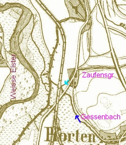
A vintage topographic map detail showing the river systems of the Zaufensgraben, Gessenbach, and Weisse Elster, with handwritten annotations marking their locations.
A historical map excerpt illustrating the course and confluence point of the Zaufensgraben stream.

Zaufensgraben history and protected-area timeline

The name Zaufensgraben derives from the Middle High German word zauche, which can mean either dry or boundary. Both senses fit the stream, since it does not flow year-round and historically also marked the southeastern boundary of Gera's municipal territory. The valley has been entangled with the city's economy for centuries. From the sixteenth to the eighteenth century, small-scale attempts were made to mine copper ore in the upper Zaufensgraben, and a limestone quarry operated in the area in later periods. Around 1900 a brickworks also used the valley.

A particularly vivid chapter came with the Gera-Meuselwitz-Wuitzer Eisenbahn, a metre-gauge railway that ran along the left side of the Zaufensgraben from 1901 to 1969. The railway's planned closure at the end of 1970 was overtaken by events on 3 May 1969, when severe flooding along the Zaufensgraben washed out the track in several places, inundated the Gera-Pforten station yard, and left it under thick mud. The station was afterwards briefly repurposed as a bus terminal for about twenty years, and the former railway buildings were eventually replaced by a housing settlement. The old, undersized culvert in the lower Zaufensgraben, which contributed to the severity of the flooding, survives to the present day.

Zaufensgraben landscape and geographic character

The landscape of the Zaufensgraben is shaped by a short, steep stream cutting through older sedimentary rock within the limits of a mid-sized German city. The stream's middle section forms a narrow, v-shaped valley, a Kerbtal, that contrasts with the flatter surroundings of Gera to the west and the open ground near the airfield to the northeast. The bedrock here is largely Zechstein and Rotliegend, while the lower course has accumulated thin deposits of meadow loam.

Above the valley the Ronneburger Höhe rises to about 297 meters above sea level, topped by the Ferberturm lookout tower. Nearby, just north of an arched bridge at the village of Zschippern, a Zechstein reef breaks the surface, adding an interesting small-scale geological landmark to an otherwise urban setting. The steepest part of the stream maintains an average gradient of more than three percent, which is unusually sharp for streams of this size in the Weiße Elster system around Gera.

Zaufensgraben ecosystems, habitats, and plant life

The protected zone along the Zaufensgraben preserves a thin band of older trees and unmanaged valley habitat inside an otherwise heavily built-over cityscape. The dominant tree cover consists of willows, which line sections of the stream where the valley has not been disturbed by modern development. The landscape protection area was reportedly affected in places by unauthorized construction work linked to the CJD, an issue that points to ongoing pressure on this small green corridor.

The vegetation and structure of the valley provide habitat for woodland birds, small mammals, amphibians and reptiles that thrive at the interface between dense urban land use and a sheltered, partly shaded stream valley.

Zaufensgraben wildlife and species highlights

Wildlife along the Zaufensgraben is modest but ecologically varied for such a short urban watercourse. Stock ducks have been observed on the stream itself, though the fauna is generally not strongly water-dependent. The surrounding trees and scrub support a community of woodland and edge-of-woodland birds that includes goldfinch, long-tailed tit, goldcrest, Eurasian nuthatch, Eurasian jay, treecreeper, Eurasian wren, hawfinch, great spotted woodpecker, European green woodpecker, common buzzard and Eurasian sparrowhawk.

Reptiles such as slow worm and common lizard, together with grass snake, common toad, common frog and smooth newt show that the valley retains a functioning amphibian and reptile presence alongside its bird community. The mix reflects a small but relatively undisturbed linear habitat embedded within a larger urban matrix.

Zaufensgraben conservation status and protection priorities

The principal conservation value of the Zaufensgraben is the formal protection of its narrow middle valley as the landscape protection area of the same name, a designation that preserves about eleven hectares of older tree stands and valley habitat within the city of Gera. With eleven hectares, it is the smallest formal landscape protection area within the city, and therefore a compact but locally significant protected zone.

The conservation context is shaped by the tension between city development and ecological continuity. The stream corridor has been modified by infrastructure crossings, including road bridges and the line of a former railway, and parts of the protected area have reportedly suffered from unauthorized construction activity. At the same time, the steep gradient and occasional flash floods show that the valley remains a dynamic hydrological feature that requires ongoing attention to flood management, particularly given the lingering presence of an undersized culvert in the lower course.

Zaufensgraben cultural meaning and human context

Culturally, the Zaufensgraben is woven into the identity of southeastern Gera not only as a landscape boundary, but also through its industrial and transport heritage. The valley hosted historical copper mining and later quarrying and brickmaking, and for much of the twentieth century the Gera-Meuselwitz-Wuitzer narrow-gauge railway followed the stream, connecting the area with neighbouring towns to the south.

Nearby the valley lies the Lindenthaler Hyänenhöhle, a cave site on the Pfortener Straße that was occupied in the Paleolithic and that links the Zaufensgraben area to the deeper prehistory of the Gera region. Together, the stream's edge-of-city setting, its railway heritage, and its archaeological neighbourhood give the small valley a rich local significance well beyond its modest size.

Top sights and standout views in Zaufensgraben

The Zaufensgraben's chief highlights are concentrated along its short course. These include the small landscape protection area, the unusually steep gradient within the Weiße Elster system, the older willow stands in the unmanaged valley sections, and the geological contrast between Zechstein rock and a small Zechstein reef near Zschippern. Cultural landmarks such as the remains of the Gera-Meuselwitz-Wuitzer Eisenbahn route and the nearby Lindenthaler Hyänenhöhle add a sense of layered history.

A walk along the marked paths within or alongside the valley reveals the most distinctive aspects of the Zaufensgraben: steep valley walls, woodland birdsong in a city setting, occasional amphibians along the banks, and a series of small bridges, including an old arched bridge at Zschippern and a replacement footbridge near the former Colliser Straße.

Best time to visit Zaufensgraben

The Zaufensgraben can be visited at any time of year, but the experience varies significantly with season. Spring and early summer are the most rewarding periods for the valley's nature, when amphibians and reptiles are active around the watercourse, woodland birds are most vocal in the willow stands, and the surrounding vegetation is at its freshest.

Late spring and summer also coincide with the season when the stream is most likely to carry water along more of its length, while late summer and autumn in dry years can expose the intermittent character of the lower reaches, where the flow regularly ceases for months at a time, and shed light on the geometry of the steep valley itself.

Monthly climate preview

Monthly temperature ranges and daily precipitation averages recorded across a representative coordinate in Thuringia

Zaufensgraben Climate Normals, Long Term Temperature and Precipitation Patterns

Historical climate data for Zaufensgraben records measured monthly temperature variations alongside steady long term precipitation averages from NASA observations. Detailed twelve month climate statistics provide a complete monthly breakdown of average temperatures and precipitation totals.
Annual mean9 °C
-1 °C19 °C
Jan-1°
Feb
Mar
Apr
May13°
Jun17°
Jul19°
Aug19°
Sep14°
Oct
Nov
Dec
Warmest month
July

19.1 °C

Coolest month
January

-0.9 °C

Wettest month
July

2.6 mm/day

Driest month
April

1.3 mm/day

Park location guide

Geography guide, regional context, and park location map for Zaufensgraben

Zaufensgraben park geography, regions, and map view in Germany

Understand where Zaufensgraben sits in Germany through a broader geographic reading of the surrounding landscape, nearby location context, and its mapped position within the national park landscape.

How Zaufensgraben fits into Germany

Germany is a federal republic in Western and Central Europe with a population of over 83 million across sixteen constituent states. It is Europe's largest economy by nominal GDP and a major global exporter and importer. The capital is Berlin, and the country borders Denmark, Poland, Czech Republic, Austria, Switzerland, France, Luxembourg, Belgium, and the Netherlands.

Wider geography shaping Zaufensgraben in Germany

Germany is located in Western and Central Europe, spanning 357,022 km². It borders Denmark to the north, Poland and the Czech Republic to the east, Austria and Switzerland to the south, and France, Luxembourg, Belgium, and the Netherlands to the west. The country has coastlines on the Baltic Sea and North Sea to the north, with the Alps located in the southern region.

Map view of Zaufensgraben

Use this park location map to pinpoint Zaufensgraben in Germany, understand its exact geographic position, and read its mapped placement within the surrounding landscape more clearly.

Pigeon | © OpenStreetMap contributors

Location context for Zaufensgraben

Thuringia

Visual exploration of steep stream valleys and protected habitats

Zaufensgraben Photos and Landscape Scenery in Thuringia

Visual documentation of Zaufensgraben reveals the dramatic topography of its steep valley corridor, mature willow stands, and unique geological formations. Examining these protected area views provides deeper insight into the rugged terrain and urban nature surrounding this Thuringian stream.

A vintage topographic map detail showing the river systems of the Zaufensgraben, Gessenbach, and Weisse Elster, with handwritten annotations marking their locations.

A path winds through a wooded area in Zaufensgraben, framed by large, gnarled willow trees with thick trunks and green foliage.

Park atlas

Compare regional stream valleys and protected natural areas across Thuringia

Explore Parks Near Zaufensgraben and Surrounding Protected Landscapes

Browse other protected areas near Zaufensgraben to examine similar stream valleys and urban nature reserves across the region. Continuing the geographic comparison reveals broader patterns in local topography and protected landscapes.
Protected areaThuringia
About 22 km away#1 closest

South

Wälder um Greiz und Werdau: Protected Landscape and Regional Woodland Atlas for Thuringia

Continuous forest terrain on the Thuringia and Saxony border

The protected landscape of Wälder um Greiz und Werdau covers rolling hills and valleys between the Pleiße and Weiße Elster rivers. Use this atlas resource to understand the park's mapped boundaries, forest pond distribution, and its role as a green corridor between regional townscapes.

Area
62 km²
Established
1961
Relief
Upland
Climate
Temperate
A horizontal watercolor painting of a wooden boardwalk path cutting through a forest clearing with scattered pine trees, rendered in soft light tones.
Nature reserveThuringia
About 24 km away#2 closest

South

Pöllwitzer Wald Nature Reserve: Geographic Overview and Protected Area Mapping

Historic forest landscapes in the Thuringia region

Pöllwitzer Wald represents a dense, historically significant nature reserve located near the Thuringia and Saxony border. This detailed overview covers the essential geographic features, including the unique moorland basin, coniferous forest transitions, and the remnants of early modern log floating infrastructure that shaped the regional topography.

Area
9.62 km²
Relief
Upland
Climate
Temperate
Access
Easy access
Nature reserveThuringia
About 26 km away#3 closest

Northeast

Phönix Nord Nature Reserve: Mapped Protected Area in the Altenburger Land of Thuringia

A restored post-mining mosaic of heath, scrub, and woodland

Phönix Nord preserves a unique post-mining landscape shaped by historic lignite extraction. This nature reserve in Thuringia features a mosaic of rewilded slopes and reclaimed mineral soils, managed as a vital habitat for native species. Through its distinct topography and conservation efforts, it stands as a key example of industrial renaturation in central Germany.

Area
1.672 km²
Established
2008
IUCN
IV
Relief
Lowland
Nature reserveSaxony
About 27 km away#4 closest

Southeast

Waschteich Reuth Nature Reserve: Mapped Wetland Landscapes of the Saxony Vogtland

Protected pond habitats and regional woodland ecosystems

Waschteich Reuth serves as a compact yet ecologically rich nature reserve in the Vogtland. Its protected boundaries encompass a traditional pond with floating-leaf vegetation, damp meadows, and native oak-hornbeam forest. This site stands as a prime example of Saxony's wetland heritage, illustrating the importance of small-scale habitat preservation within the broader German river network.

Area
0.212 km²
Established
1995
Water
Major water bodies
A horizontal watercolor painting depicting a soft-focus forest in the foreground and rolling hills in the background.
Nature reserveThuringia
About 29 km away#5 closest

East

Leinawald Nature Reserve: Mapping the Protected Forests and Wetland Habitats of Eastern Thuringia

A comprehensive look at the landscape geography, pond networks, and conservation status of this German woodland.

Leinawald represents a unique confluence of historical forestry, wartime heritage, and ecological recovery within the Altenburger Land region. The area is defined by its loess-mantled ridges and periodic wetland valleys, containing a complex grid of ponds, brooks, and secondary habitats formed in former quartz quarries. Understanding the environmental layers of this site reveals the intersection of natural vegetation potential and 20th century landscape transformation.

Area
18.437 km²
Established
1961
IUCN
IV
Relief
Upland
A horizontal watercolor painting showing a soft, stylized landscape of rolling green hills, gentle slopes, and a calm body of water against a light pastel sky.
Nature reserveThuringia
About 33 km away#6 closest

Southwest

Plothener Teiche Nature Reserve: Geographic Map and Protected Wetland Landscape Overview

Historic pond landscapes in the Saale-Orla-Kreis region of Thuringia

Plothener Teiche serves as a defining example of medieval-origin fishpond management in central Germany. This protected landscape combines open water basins, reed-lined margins, and woodland edges within the Thüringer Schiefergebirge and Obere Saale Nature Park. The area provides essential habitat for migratory bird populations and stands as a restored model of European wetland ecology.

Established
1967
IUCN
IV
Relief
Lowland
Climate
Temperate
A horizontal watercolor illustration depicting a wetland landscape with grassy banks, a winding stream, and reeds.
Nature reserveSachsen
About 33 km away#7 closest

Northeast

Eschefelder Teiche: Protected Wetland Landscapes and Pond Geography in Sachsen

Historic water basins and regional wetland habitats

The Eschefelder Teiche nature reserve occupies a distinctive position in the Saxon landscape, tracing a historic chain of artificial ponds from Frohburg to Eschefeld. This protected area offers insight into managed wetland ecosystems, featuring the expansive Großteich and preserved heritage structures like the Teichhaus complex, which remain central to local conservation and bird populations.

Area
5.62 km²
Relief
Lowland
Climate
Temperate
Access
Easy access
Nature reserveThuringia
About 37 km away#8 closest

Northwest

Lohholz Nature Reserve: Protected Forest and Meadow Mosaic in Thuringia

Mapped deciduous woodlands and river valley meadow geography

Lohholz constitutes an isolated nature reserve in Thuringia, showcasing a distinct mosaic of broadleaf forest and traditional orchard meadows. The terrain slopes toward the Saale river valley, featuring varied grassland communities and a vital spring-fed brook. This protected area offers a look at forest preservation within a landscape predominantly utilized for agricultural purposes.

Area
0.304 km²
Established
1995
IUCN
IV
Relief
Upland

Common questions about visiting, size, designation, and location context for Zaufensgraben

Zaufensgraben FAQs for park facts, access, geography, and protected area context

Find quick answers about Zaufensgraben, including protected-area facts, park geography, trail and visitor context, and how the park fits into its surrounding country and regional landscape.
MoriAtlas Explorer

Continue Your Protected Areas Search Across the Global Atlas

Deepen your exploration by continuing the structured search for national parks and protected areas worldwide. Utilize the comprehensive filtering capabilities to compare different conservation landscapes and refine your understanding of global park geography. Discover more about the distribution and characteristics of protected natural areas.

Global natural geography