
Mori Atlas logo
Protected landscapePřírodní park Ždánický les

Mapping the rolling hills, mature beech and oak forests, and floodplain meadows of South Moravia

Přírodní park Ždánický les: A Comprehensive Protected Landscape and Regional Woodland Atlas

Přírodní park Ždánický les serves as a significant protected area within the Central Moravian Carpathians of Czechia. This expansive woodland complex spans nearly 182 square kilometers, characterized by mature beech and oak forests that create a cohesive natural terrain. Beyond its forested ridges, the park features a rare network of floodplain meadows along stream corridors, preserving regional ecological integrity and traditional landscape patterns in the heart of South Moravia.

nature parkCentral Moravian Carpathiansbroadleaf forestbeech forestoak forestfloodplain meadows
A stylized flat illustration of a rolling green landscape with a winding dirt path, scattered trees, and small red flowers in the foreground against a cloudy sky.

Přírodní park Ždánický les

Protected landscape

Park overview

Structured park overview, official facts, and landscape profile for Ždánický les Nature Park

Ždánický les Nature Park park facts, protected area profile, and essential visitor context

Review the core facts for Ždánický les Nature Park, including designation, size, terrain, visitor scale, habitats, and operating context in one park-focused overview.

About Ždánický les Nature Park

Ždánický les Nature Park is a substantial protected landscape in southeastern Moravia, set within the Central Moravian Carpathians. Covering approximately 182 square kilometers, it extends across parts of the Vyškov and Hodonín districts and forms one of the region's most significant continuous woodland areas. The park was formally designated on 24 April 1996, reflecting recognition of the area's natural value and its importance for regional biodiversity conservation.

The landscape is defined by its forested character. Rolling hills and ridges carry extensive woodland dominated by broadleaf species, with preserved enclaves of mature beech and oak forest representing particularly valuable remnants of the region's original forest cover. Between the wooded ridges, valley floors and streams support a complex of floodplain meadows that has been maintained in good ecological condition, adding structural and habitat diversity to the landscape.

Biodiversity is a central theme of the park. The combination of old-growth broadleaf remnants, mixed forest, open meadow habitats, and streams supports a wide range of protected plant and animal species. This habitat mosaic gives the park an importance that extends beyond its immediate surroundings, linking protected areas within the broader Moravian Carpathian system.

As a nature park rather than a strictly regulated reserve, Ždánický les aims to balance conservation with the continuation of traditional landscape management. The result is a working Moravian countryside where natural forest patterns, meadow ecosystems, and light human land use coexist, providing both ecological value and a distinctive regional character.

Quick facts and research context for Ždánický les Nature Park

Ždánický les Nature Park is a protected landscape area in the Central Moravian Carpathians, covering about 182 square kilometers across the Vyškov and Hodonín districts of the Czech Republic. Established on 24 April 1996, it functions as a quiet nature park rather than a strictly regulated national park.

The park protects enclaves of beech and oak forest, along with a notable preserved complex of floodplain meadows. Its territory supports numerous protected plant and animal species, reflecting its role as a regional biodiversity refuge within the Moravian Carpathian landscape.

Protection and recognition

Documented terrestrial protection scope and conservation designations

Přírodní park Ždánický les Protection Status and Recognition Facts

Terrestrial protection status for Přírodní park Ždánický les outlines the documented conservation framework governing the landscape. Structured records detail the established management scope and verified recognition sources for the protected area.

Protection details

Protection scope
Terrestrial
Park context

Deeper park guide and search-rich context for Ždánický les Nature Park

Ždánický les Nature Park history, landscape, wildlife, and travel context

Explore Ždánický les Nature Park through its history, landscape character, ecosystems, wildlife, conservation priorities, cultural context, and seasonal travel timing in a structured park guide built for atlas discovery and search intent.

Why Ždánický les Nature Park stands out

Ždánický les Nature Park is especially known for its extensive woodlands in the Central Moravian Carpathians, where enclaves of beech and oak stand alongside mixed forest. The park's preserved floodplain meadow complex is one of its most ecologically distinctive features, providing habitat variety within an otherwise forest-dominated setting. The area is also valued for its quiet, unspoiled character. Recognized as a protected landscape in 1996, it remains a regional example of how Moravian forest landscapes, valley meadows, and traditional land uses can be maintained together within a single coherent protected area.
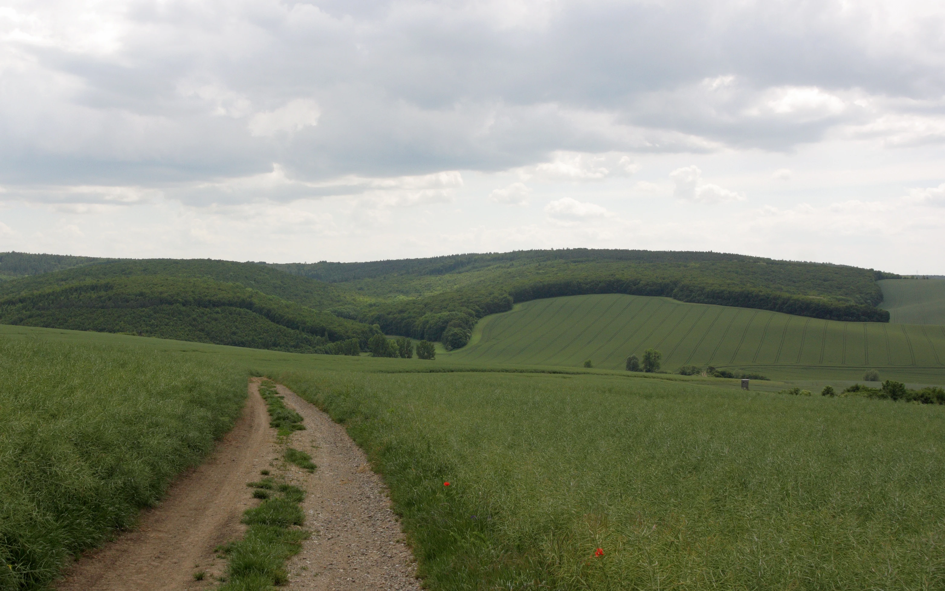
A dirt path leads through a green field toward a rolling, forested hillside under a cloudy sky.
The western edge of the Ždánický les forest near Kobeřice.

Ždánický les Nature Park history and protected-area timeline

Ždánický les Nature Park was officially established on 24 April 1996, when it was designated a quiet protected landscape area in the Central Moravian Carpathians. The decision reflected growing awareness of the natural value of the Ždánický les woodlands and the importance of safeguarding their characteristic forest and meadow habitats for future generations.

The broader forest complex had long been recognized regionally as a defining feature of the Moravian landscape between the Vyškov and Hodonín districts. Its formal protection as a nature park represented a step toward consolidating this recognition into a single managed area covering nearly 182 square kilometers.

The establishment of the park also created a framework for coordinating conservation of the area's beech and oak woodland remnants and its traditional floodplain meadow systems, supporting ongoing landscape management consistent with the park's quiet, low-impact character.

Ždánický les Nature Park landscape and geographic character

The landscape of Ždánický les Nature Park is shaped by the foothills of the Central Moravian Carpathians. Rolling ridges and wooded hills form the dominant terrain, with extensive forest cover giving the area its strong, cohesive character. The forest pattern is varied: broadleaf stands, mixed woodland, and patches of older beech and oak forest create a textured canopy over the slopes.

Between the forested ridges, valley floors open into flatter ground where streams and small watercourses have shaped the terrain. These valleys support the park's most distinctive open landscape feature: a preserved complex of floodplain meadows that contrasts sharply with the surrounding woodland and adds visual as well as ecological diversity.

The combination of wooded hills, valley meadows, and small watercourses gives the park a layered landscape structure. It is a gently contoured countryside rather than an alpine or dramatic setting, with the appeal coming from the continuity and quiet integrity of the natural scenery.

Ždánický les Nature Park ecosystems, habitats, and plant life

Ecologically, Ždánický les Nature Park represents a valuable mosaic of Moravian Carpathian habitats. Its broadleaf forests, including beech and oak woodland remnants, are among the most important features, providing habitat continuity in a region where such older forest patches have become increasingly rare. Mixed woodland fills the broader forest matrix, supporting a wide range of woodland species.

Along the streams and valley floors, the preserved floodplain meadow complex contributes a contrasting habitat type. These open, species-rich meadows add ecological variety and serve as an important complement to the surrounding forest, particularly for species associated with open and semi-open countryside.

Together, the forested hills, valley meadows, and aquatic elements create a habitat network that supports both woodland and open-ground biodiversity. This mosaic is the ecological foundation of the park and a key reason for its protected status.

Ždánický les Nature Park wildlife and species highlights

The varied habitat mosaic of Ždánický les Nature Park supports a diverse animal community typical of Central Moravian Carpathian landscapes. The mature beech and oak woodlands provide habitat for forest-dwelling species, while the open floodplain meadows and valley corridors support birds and other fauna associated with semi-open countryside.

A range of protected animal species is present in the park, reflecting the conservation value of both the woodland remnants and the meadow systems. The combination of forest cover, open ground, and watercourse environments gives the park the ecological breadth needed to maintain species with differing habitat requirements within a single protected area.

Ždánický les Nature Park conservation status and protection priorities

Ždánický les Nature Park plays a meaningful role in the conservation of Moravian Carpathian natural heritage. Its protected status, in place since 1996, safeguards one of the region's most extensive woodland complexes, including old-growth enclaves of beech and oak that are of particular ecological importance.

The park also protects a preserved complex of floodplain meadows, a habitat type that has declined across much of Central Europe. Maintaining this mosaic of forest and open meadow habitats within a single protected area strengthens regional biodiversity corridors and supports the long-term survival of protected plant and animal species native to the area.

As a nature park, the area balances conservation with continued traditional land use, contributing to the maintenance of Moravian cultural landscapes while preserving their natural foundations.

Ždánický les Nature Park cultural meaning and human context

Ždánický les lies in a region where woodland landscapes and traditional rural land use have long shaped local identity. The Central Moravian Carpathians, between the Vyškov and Hodonín districts, are historically associated with forested countryside interspersed with cultivated valleys. The nature park reflects this cultural-geographic setting, where the protected designation preserves not only natural habitats but also the broader character of the Moravian countryside.

The continuation of traditional landscape management within the park, particularly in relation to the preserved floodplain meadows, connects the area's ecological value to its rural heritage. This blend of natural and cultural landscape is part of what gives the Ždánický les its regional significance.

Top sights and standout views in Ždánický les Nature Park

Ždánický les Nature Park stands out for the scale and continuity of its Moravian Carpathian woodland, including particularly valuable beech and oak forest remnants. The preserved floodplain meadow complex along its streams is another defining feature, offering habitat diversity within an otherwise forest-dominated landscape.

Established in 1996 and covering nearly 182 square kilometers, the park represents a coherent regional example of how broadleaf woodland, mixed forest, and traditional meadow landscapes can be maintained together. Its character as a quiet nature park, rather than a heavily regulated reserve, reinforces its identity as a working Moravian landscape shaped by both natural patterns and long-standing human presence.

Best time to visit Ždánický les Nature Park

Ždánický les Nature Park is best experienced in late spring and early summer, when the floodplain meadows are at their most varied and the forest canopy is fully developed. This period offers the richest combination of flowering meadow species and active birdlife across both woodland and open habitats.

Autumn also has strong appeal for visitors interested in forest scenery, as the broadleaf woodlands, including the beech and oak stands, display seasonal color across the rolling Carpathian ridges. Winter visits emphasize the quiet, forested character of the park, especially along the more sheltered valleys and meadow edges.

Monthly climate preview

Long-term representative monthly temperature and precipitation rhythm

Přírodní park Ždánický les Climate Normals and Annual Temperature Patterns

Representative coordinate records show measured monthly temperature ranges and precipitation averages spanning from sub-zero winter lows to warm summer highs. Detailed twelve-month climate normals provide a complete statistical profile of long-term weather patterns across the landscape.
Annual mean9 °C
-3 °C21 °C
Jan-3°
Feb-1°
Mar
Apr
May15°
Jun19°
Jul21°
Aug21°
Sep15°
Oct
Nov
Dec-2°
Warmest month
July

21 °C

Coolest month
January

-2.7 °C

Wettest month
June

2.4 mm/day

Driest month
February

1.1 mm/day

Park location guide

Geography guide, regional context, and park location map for Ždánický les Nature Park

Ždánický les Nature Park park geography, regions, and map view in Czechia

Understand where Ždánický les Nature Park sits in Czechia through a broader geographic reading of the surrounding landscape, nearby location context, and its mapped position within the national park landscape.

How Ždánický les Nature Park fits into Czechia

Czech Republic is a landlocked Central European country with a population of approximately 10.9 million people. The nation was established as an independent state on January 1, 1993, following the dissolution of Czechoslovakia. Its capital and largest city is Prague, with other major urban centers including Brno, Ostrava, Plzeň, and Liberec.

Wider geography shaping Ždánický les Nature Park in Czechia

The Czech Republic is a landlocked country in Central Europe. It is bordered by Germany to the west, Austria to the south, Poland to the northeast, and Slovakia to the southeast. The landscape is predominantly hilly, with the territory covering 78,871 square kilometers.

Map view of Ždánický les Nature Park

Use this park location map to pinpoint Ždánický les Nature Park in Czechia, understand its exact geographic position, and read its mapped placement within the surrounding landscape more clearly.

Pigeon | © OpenStreetMap contributors

Visual reference of woodland terrain, valley meadows, and protected habitats in Moravia

Přírodní park Ždánický les Photos and Landscape Scenery

Visual documentation captures the rolling forested terrain, mature beech stands, and open floodplain meadows defining the regional character of Přírodní park Ždánický les. Examining park imagery reveals the intricate landscape patterns, valley ecosystems, and protected woodland environments across the Central Moravian Carpathians.

A dirt path leads through a green field toward a rolling, forested hillside under a cloudy sky.

Park atlas

Compare regional woodland terrain and neighboring Moravian protected areas

Parks Near Přírodní park Ždánický les and Connected Protected Landscapes

Continue exploring regional park geography by comparing adjacent woodland reserves and protected valleys around Přírodní park Ždánický les. Examining nearby protected landscapes reveals broader patterns of forest continuity and valley meadow ecosystems across the Central Moravian Carpathians.
Nature reserveJihomoravský kraj
About 10 km away#1 closest

North

Volkramy Nature Reserve: Geography and Protected Habitat Mapping in South Moravia

Sub-Pannonian steppe grassland and sandy landscape terrain.

Volkramy serves as a critical nature monument in the Czech Republic, protecting a dense concentration of rare steppe flora and dry-grassland ecosystems on sandy substrates. This protected area within the Jihomoravský kraj region showcases a unique combination of open grassland, orchard heritage, and post-industrial sand quarry habitats that provide nesting sites for specialized bird colonies.

Area
0.072 km²
Established
2023
IUCN
IV
Relief
Upland
Natural monumentJihomoravský kraj
About 16 km away#2 closest

Northwest

Velatická slepencová stráň: A Protected Natural Monument in South Moravia, Czech Republic

Mapping the rare steppe vegetation and conglomerate geology of Jihomoravský kraj.

Velatická slepencová stráň serves as a critical refuge for thermophilous steppe communities within the Jihomoravský kraj region. The site features distinctive conglomerate outcrops and a rich assembly of dry-grassland plants. This mapping resource provides a comprehensive geographic overview of the protected landscape and its specific ecological configuration.

Area
0.017 km²
Established
1951
IUCN
IV
Relief
Upland
Natural monumentJihomoravský kraj
About 19 km away#3 closest

West

Velké Družďavy Natural Monument: Steppe Geography and Protected Landscapes in Jihomoravský kraj

Rare xerothermic habitats on Miocene sandy substrates

Velké Družďavy represents a vital, small-scale protected area in the Czech Republic. Defined by its south-facing slope and sandy Miocene substrate, the site supports significant populations of thermophilic plants. This natural monument illustrates the challenges of managing xerothermic steppe vegetation against encroaching forest succession, providing a distinct geographic focal point within the regional protected area network of South Moravia.

Area
0.014 km²
Established
1953
IUCN
IV
Relief
Upland
A soft watercolor illustration depicting a panoramic view of rolling green hills, distant light purple mountain ridges, and a central valley stream.
Protected landscapeCzechia
About 21 km away#4 closest

North

Přírodní park Říčky: Protected Landscape and Highland Geography in Czechia

Deep exploration of stream-carved valleys and karst-influenced terrain.

Přírodní park Říčky preserves a vital transitional environment within the Drahanská vrchovina highlands. This protected area integrates diverse ecosystems, including upland beech enclaves and orchid-rich wet meadows, tied together by a complex network of springs and streams that carve through the sedimentary and limestone geology of the region.

Area
30.05 km²
Established
1984
Relief
Upland
Climate
Temperate
Nature reserveJihomoravský kraj
About 22 km away#5 closest

Northwest

Velká Klajdovka Nature Reserve: Steppe and Forest-Steppe Landscape in Jihomoravský Kraj

Ecologically rich protected limestone slopes and terrain near Brno

Velká Klajdovka is a protected natural monument distinguished by its high-value thermophilic vegetation and complex soil structures. Located on the flank of the Hády massif, the reserve offers a unique study of forest-steppe mosaics, rare entomological diversity, and dry oak woodlands that thrive on the boundary of varied geological substrates.

Area
0.09 km²
Established
1988
IUCN
IV
Relief
Upland
A watercolor painting showing a panoramic landscape with green rolling hills, light green meadows, and soft purple distant mountain ridges under a pale sky.
Natural monumentJihomoravský kraj
About 24 km away#6 closest

Northeast

Roznitál Natural Monument: Protected Steppe Biodiversity and Regional Landscape Context

A rare habitat island within the South Moravian agricultural mosaic

Located in the Vyškov district, Roznitál is a formally protected natural monument defined by its open, dry grassland and thermophilic flora. This site provides a vital refuge for relict plant communities that have largely vanished from the surrounding farmed countryside, offering a clear example of small-scale landscape conservation in the heart of Moravia.

Area
0.01 km²
Established
1990
IUCN
IV
Relief
Lowland
Watercolor illustration of a karst landscape featuring hills, a lake, and cave-like rock formations with green vegetation
Protected landscapeSouth Moravian Region
About 25 km away#7 closest

Northwest

Moravian Karst Protected Landscape: Detailed Geographic and Cave System Atlas

Mapped protected boundaries and karst phenomena in the South Moravian Region.

Moravian Karst, designated a Protected Landscape Area, offers a profound look into complex karst geology within the South Moravian Region. This entry within MoriAtlas facilitates a structured discovery of its approximately 92 square kilometers, featuring an intricate network of over 1,100 caves and gorges. Users can explore the mapped extent of this geological treasure, understand its relationship with the surrounding regional geography, and appreciate the unique formations sculpted by underground water systems, including the iconic Macocha Abyss.

Area
92 km²
IUCN
V
Scope
Terrestrial
Water
Minor water
A watercolor painting showing a stylized, panoramic landscape of rolling green hills, trees, and distant soft mountains.
Natural monumentZlínský kraj
About 26 km away#8 closest

East

Medlovický lom Natural Monument: Geomorphological and Geological Atlas of Zlínský Kraj

Protected geological profile and amphibian habitat in eastern Moravia

Explore the geological heritage of Medlovický lom, a protected site defined by its extensive exposure of fired clay known as porcelanite. This former quarry offers a window into the geomorphological history of the Vážanská vrchovina, contrasting its artificial rock faces with the surrounding agricultural terrain and hills of the Moravian region. The site acts as both an educational geological record and a small-scale sanctuary for aquatic wildlife, maintaining its status as a landmark of local earth science.

Area
0.011 km²
Established
1997
IUCN
III
Relief
Upland

Common questions about visiting, size, designation, and location context for Ždánický les Nature Park

Ždánický les Nature Park FAQs for park facts, access, geography, and protected area context

Find quick answers about Ždánický les Nature Park, including protected-area facts, park geography, trail and visitor context, and how the park fits into its surrounding country and regional landscape.
MoriAtlas Explorer

Continue Your Protected Areas Search Across the Global Atlas

Deepen your exploration by continuing the structured search for national parks and protected areas worldwide. Utilize the comprehensive filtering capabilities to compare different conservation landscapes and refine your understanding of global park geography. Discover more about the distribution and characteristics of protected natural areas.

Global natural geography