Mori Atlas logo
Wildlife reserveZugvogelschutzgebiet Sable River

A vital protected wetland sanctuary on the Atlantic coast of Nova Scotia, Canada

Zugvogelschutzgebiet Sable River Wildlife Reserve and Coastal Estuarine Landscape Geography

(Sable River Migratory Bird Sanctuary)

The Zugvogelschutzgebiet Sable River serves as a protected wildlife reserve located along the Atlantic coast of southwestern Nova Scotia. This coastal sanctuary consists primarily of open estuarine waters and salt marshes, providing a critical refuge for migratory waterfowl. Within the regional network of protected coastal wetlands, the reserve maintains an ice-free habitat that supports seasonal bird populations across the broader South Shore geography.

migratory bird sanctuaryestuarine habitatAtlantic coastsalt marshwaterfowl refugeNova Scotia

Zugvogelschutzgebiet Sable River

Wildlife reserve

Park overview

Structured park overview, official facts, and landscape profile for Sable River Migratory Bird Sanctuary

Sable River Migratory Bird Sanctuary park facts, protected area profile, and essential visitor context

Review the core facts for Sable River Migratory Bird Sanctuary, including designation, size, terrain, visitor scale, habitats, and operating context in one park-focused overview.

About Sable River Migratory Bird Sanctuary

The Sable River Migratory Bird Sanctuary is one of a long chain of Canadian Migratory Bird Sanctuaries administered by the Canadian Wildlife Service. Created in 1941, it sits on the southwestern edge of the Nova Scotia peninsula along the Atlantic coast, about 35 kilometers southwest of Liverpool. Its setting is defined by the mouth of the Sable River, whose estuary opens onto the Atlantic through a shallow bay roughly ten kilometers deep.

The sanctuary's territory is overwhelmingly estuarine. Open tidal waters of the Sable River estuary make up about 90 percent of the protected area, while the remainder is dominated by salt marsh along the edges of the estuary. This mosaic of calm water and vegetated tidal shoreline creates ideal conditions for waterfowl, particularly species that depend on sheltered, productive wetland habitats along their migratory routes.

The sanctuary gains regional significance through its proximity to two neighboring migratory bird sanctuaries, Port Hebert and Port Joli. Together, the three reserves anchor the Important Bird Area known as South Shore (Port Joli sector). They function as a coordinated system rather than as isolated refuges, providing overlapping habitat that supports large flocks and offers alternative sites when conditions in any single estuary change.

Although the sanctuary is very small by national-park or even provincial-park standards, its coastal accessibility, established legal protection, and integration with a broader Important Bird Area give it a meaningful role in Canada's migratory bird conservation framework.

Quick facts and research context for Sable River Migratory Bird Sanctuary

The Sable River Migratory Bird Sanctuary is a federal migratory bird sanctuary established in 1941 in the Canadian province of Nova Scotia. It covers about 3.13 square kilometers at the mouth of the Sable River on the southwestern Atlantic coast of the Nova Scotia peninsula. Roughly 90 percent of its area is open estuarine water, with salt marshes accounting for about 9 percent of the protected surface. It is administered by the Canadian Wildlife Service and forms part of the Important Bird Area called South Shore (Port Joli sector).

Protection and recognition

Explore verified conservation data, official status records, and management parameters.

Zugvogelschutzgebiet Sable River Protection Status and Documented Records

Examine documented protection status metrics and official designation parameters recorded for Zugvogelschutzgebiet Sable River within global datasets. Review verified registry entries and administrative tracking details associated with this protected natural area profile.

Protection details

WDPA ID
65755
Park context

Deeper park guide and search-rich context for Sable River Migratory Bird Sanctuary

Sable River Migratory Bird Sanctuary history, landscape, wildlife, and travel context

Explore Sable River Migratory Bird Sanctuary through its history, landscape character, ecosystems, wildlife, conservation priorities, cultural context, and seasonal travel timing in a structured park guide built for atlas discovery and search intent.

Why Sable River Migratory Bird Sanctuary stands out

The sanctuary is best known for its role as a wintering and staging area for Canada Geese and other waterfowl in southwestern Nova Scotia. Its ice-free estuarine waters make it an important refuge during cold months, especially when nearby bays elsewhere along the South Shore freeze over. The combination of open estuarine water, salt marsh, and integration with neighboring Port Hebert and Port Joli sanctuaries defines its ecological identity. The site is also recognized for its contribution to the South Shore Important Bird Area, where the three adjoining sanctuaries jointly support very large seasonal concentrations of geese. This regional, multi-sanctuary waterfowl system is what sets Sable River apart from many other small single-site estates in Atlantic Canada.

Sable River Migratory Bird Sanctuary history and protected-area timeline

The Sable River Migratory Bird Sanctuary was officially established in 1941, placing it among the earlier wave of federal migratory bird sanctuaries created in eastern Canada. Its designation reflected the early twentieth-century recognition that key coastal wetland sites along the Atlantic coast required formal protection as waterfowl habitat.

The sanctuary's location was chosen for the ecological value of the Sable River estuary as a wintering and staging site for waterfowl, including large numbers of Canada Geese. Over time, the site's importance was further underscored by its inclusion in the Important Bird Area program under the designation South Shore (Port Joli sector), which also incorporates the adjacent Port Hebert and Port Joli sanctuaries. Administration has remained with the Canadian Wildlife Service, continuing the site's role as part of Canada's network of federal migratory bird reserves.

Sable River Migratory Bird Sanctuary landscape and geographic character

The sanctuary occupies the inner portion of an open estuarine bay at the mouth of the Sable River on Nova Scotia's South Shore. The estuary extends inland from the Atlantic for roughly ten kilometers and forms a shallow, sheltered inlet shaped by tidal exchange between the river and the sea.

Open water dominates the protected area, accounting for approximately 90 percent of its surface and defining its visual character. The remaining land area consists almost entirely of salt marshes lining the margins of the estuary, where tidal influence alternates between inundation and exposure. The Highway 103 corridor runs roughly a kilometer to the north, marking the boundary between the protected estuarine environment and the broader settled South Shore landscape of Nova Scotia.

Sable River Migratory Bird Sanctuary ecosystems, habitats, and plant life

Ecologically, the sanctuary is a coastal estuarine system defined by the interplay of saltwater inflow, freshwater discharge from the Sable River, and tidal marsh habitat. The mix of calm open water and vegetated tidal shoreline supports a rich base of invertebrates, small fish, and aquatic vegetation that underpins the area's importance for waterfowl.

Salt marsh forms the other major habitat type, covering most of the non-water portion of the sanctuary. These marshes likely support typical salt-tolerant plant communities adapted to daily tidal flooding. Together, the open water and salt marsh create a compact but functional estuarine ecosystem that is characteristic of small South Shore Nova Scotia river mouths.

Sable River Migratory Bird Sanctuary wildlife and species highlights

The sanctuary's wildlife value is centered on waterfowl. It serves as both a migratory stopover and a wintering site for several species, with the most prominent being large flocks of Canada Geese. The three adjoining sanctuaries, Sable River, Port Hebert, and Port Joli, together host between roughly 4,000 and 5,000 geese each year, with birds typically arriving in late September and remaining until mid-March.

In addition to geese, the sanctuary supports other waterfowl species in autumn and winter. Common and Green-winged Teal make use of the estuary during the colder months, taking advantage of the sheltered habitat. The site's role becomes especially important during severe weather, when the bays of the neighboring sanctuaries may freeze; birds can then shift to the ice-free portions of the Sable River estuary, which often remains open due to tidal flow and the moderating influence of the Atlantic.

Sable River Migratory Bird Sanctuary conservation status and protection priorities

The sanctuary's conservation significance lies primarily in its long-term protection as part of Canada's federal migratory bird sanctuary network rather than in its size. By shielding a productive estuarine system from disturbance, it provides reliable habitat for waterfowl during both migration and the harsh winter period along Nova Scotia's Atlantic coast.

Its inclusion in the South Shore (Port Joli sector) Important Bird Area strengthens its conservation role by linking it to the nearby Port Hebert and Port Joli sanctuaries. This clustering of protected estuarine sites creates redundancy in the system, ensuring that waterfowl displaced from one bay by freezing or disturbance can still find suitable habitat nearby.

The continued administration of the site by the Canadian Wildlife Service underlines its role as part of a national framework for migratory bird conservation, even though it is classified for management purposes under the strictest protected-area category.

Sable River Migratory Bird Sanctuary cultural meaning and human context

The sanctuary sits within the traditional coastal landscape of southwestern Nova Scotia, where Atlantic estuaries have long supported small-scale fishing, boat-based livelihoods, and shoreline settlements. The South Shore region has a deep cultural identity tied to the sea and to its river-mouth communities, although the sanctuary itself is a wildlife-focused federal reserve rather than a culturally anchored site.

Top sights and standout views in Sable River Migratory Bird Sanctuary

The sanctuary's clearest highlights include its 1941 establishment as part of Canada's historic Migratory Bird Sanctuary program and its integration with the South Shore Important Bird Area. The exceptionally open estuarine character, with about 90 percent open water and the remainder salt marsh, gives the site an unusually marine feel for its small size.

A further distinctive feature is the sanctuary's role as a winter refuge within a three-sanctuary cluster that includes Port Hebert and Port Joli. Together, these reserves support thousands of Canada Geese each season and provide a coordinated fallback system when ice forces birds to move between estuaries.

Best time to visit Sable River Migratory Bird Sanctuary

The most ecologically meaningful period for the sanctuary runs from late autumn through early spring, when Canada Geese and other waterfowl make use of the estuary. Late September onward brings the arrival of migrating geese, with peak numbers typically present through the colder months until around mid-March.

Late autumn and winter are thus the season during which the sanctuary's defining function is most apparent, when the contrast between ice-covered parts of the South Shore and the open Sable River estuary becomes visible. Warmer months are quieter in terms of congregating waterfowl, and the site's appeal is then more about the tranquil landscape than about visible wildlife concentrations.
Monthly climate preview

Long-term monthly temperature averages and precipitation measurements for Nova Scotia

Zugvogelschutzgebiet Sable River Climate Normals and Temperature Patterns

Representative coordinate records outline the measured annual temperature rhythm and daily precipitation rates across twelve distinct baseline months. Examining the complete monthly climate profile reveals specific long-term averages for thermal conditions and precipitation levels.
Annual mean8 °C
-3 °C18 °C
Jan-3°
Feb-3°
Mar
Apr
May10°
Jun14°
Jul18°
Aug18°
Sep15°
Oct10°
Nov
Dec
Warmest month
August

18.3 °C

Coolest month
January

-3 °C

Wettest month
December

4.2 mm/day

Driest month
July

2.6 mm/day

Park location guide

Geography guide, regional context, and park location map for Sable River Migratory Bird Sanctuary

Sable River Migratory Bird Sanctuary park geography, regions, and map view in Canada

Understand where Sable River Migratory Bird Sanctuary sits in Canada through a broader geographic reading of the surrounding landscape, nearby location context, and its mapped position within the national park landscape.

How Sable River Migratory Bird Sanctuary fits into Canada

Canada is a federal parliamentary constitutional monarchy spanning North America from the Atlantic to the Pacific and Arctic Oceans. With a population of over 41 million, it is officially bilingual in English and French at the federal level. The country gained independence from the United Kingdom through a gradual process culminating in 1982.

Wider geography shaping Sable River Migratory Bird Sanctuary in Canada

Canada occupies the northern portion of North America, sharing its longest international border with the United States. The country extends from the Atlantic Ocean to the Pacific Ocean and northward into the Arctic Ocean, giving it the longest coastline of any nation.

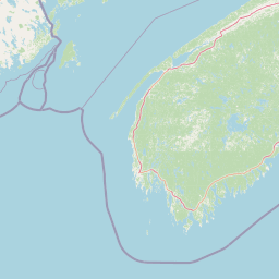
Map view of Sable River Migratory Bird Sanctuary

Use this park location map to pinpoint Sable River Migratory Bird Sanctuary in Canada, understand its exact geographic position, and read its mapped placement within the surrounding landscape more clearly.

Pigeon | © OpenStreetMap contributors

Location context for Sable River Migratory Bird Sanctuary

Nova Scotia
Park atlas

Compare regional protected areas and connected estuarine habitats across the Atlantic coast.

Explore Other Parks Near Zugvogelschutzgebiet Sable River and Surrounding Coastal Reserves

Browse protected areas and coastal wetlands located near Zugvogelschutzgebiet Sable River to understand broader regional geography. Comparing adjacent wildlife reserves helps reveal the wider network of estuarine habitats supporting waterfowl along the South Shore.
Wildlife reserveNova Scotia
2 km away#1 closest

Northeast

Haley Lake Migratory Bird Sanctuary: Protected Wildlife Reserve in Nova Scotia

Freshwater avian sanctuary and coastal nesting habitat

Haley Lake Migratory Bird Sanctuary provides a crucial freshwater refuge on the southwestern coast of Nova Scotia. This wildlife reserve features a unique lakeside environment that supports large gatherings of migratory waterfowl and a historic great blue heron breeding colony, situated between the brackish tidal flats of the surrounding estuarine landscape.

Area
0.95 km²
Established
1980
IUCN
Ia
Relief
Lowland
Wildlife reserveNova Scotia
5.7 km away#2 closest

Northeast

Zugvogelschutzgebiet Port Hebert: Coastal Protected Landscapes of Nova Scotia

Wildlife reserve and intertidal wetland geography

Spanning the shallow reaches of Port L'Hebert, this wildlife reserve serves as a foundational element of the South Shore protected area network. The sanctuary is defined by its wide tidal range, which uncovers extensive sand and mudflats to provide essential feeding grounds for migratory geese and ducks. This site offers deep insight into the coastal geography and wetland preservation status of Nova Scotia's rugged Atlantic fringe.

Area
3.46 km²
Established
1941
IUCN
Ia
Watercolor painting showing a river landscape with green trees, rolling hills, and mountains in the background
National parkNova Scotia
51 km away#3 closest

North

Kejimkujik National Park: Detailed Protected Landscape and Regional Geography

Explore mapped boundaries and geographic context in Nova Scotia.

Kejimkujik National Park offers a dedicated entry for understanding protected natural areas. As a national park in Nova Scotia, its geographic features and protected boundaries are detailed here to support atlas-based exploration. Discover the park's unique landscape context and its positioning within regional geography, providing a factual basis for comprehending its role as a conservation area.

Area
404 km²
Established
1967
IUCN
II
Visitors
75.3K annual
Wildlife reserveNova Scotia
144 km away#4 closest

North

Kentville Migratory Bird Sanctuary: A Protected Wetland Reserve in the Cornwallis River Valley

Mapped riparian ecosystems and migratory bird habitats in Nova Scotia.

Discover the unique geography of the Kentville Migratory Bird Sanctuary, a compact wildlife reserve in Nova Scotia. This protected area features a blend of river channels, open fields, and forest mosaic that serves as a seasonal sanctuary for waterfowl. Learn about the riparian terrain that defines this critical node in the broader Atlantic flyway network.

Area
5.06 km²
Established
1939
Relief
Lowland
Scope
Terrestrial
A minimalist watercolor illustration showing soft green hills in the distance, a calm body of water, and stylized reddish vegetation in the foreground.
Wildlife reserveNova Scotia
About 158 km away#5 closest

North

Île Haute Wildlife Reserve: Mapped Volcanic Geography and Coastal Protected Terrain

Bay of Fundy protected area, Nova Scotia

Rising abruptly from the Bay of Fundy, Île Haute features a steep, isolated plateau encircled by 100-meter basalt cliffs. This wildlife reserve showcases Jurassic volcanic geology and provides essential habitat for migratory seabirds and marine mammals. Gain insights into the island's unique coastal geography and its role as a protected natural sanctuary in Atlantic Canada.

Area
0.8 km²
Established
2025
Relief
Upland
Scope
Mixed
A soft watercolor painting showing a coastal landscape with green low-lying vegetation, a stretch of water, and rolling hills in the distance under a pale sky.
Wildlife reserveNova Scotia
About 159 km away#6 closest

North

Boot Island National Wildlife Area: Mapping Coastal Conservation in Nova Scotia

Protecting intertidal mudflats and migratory bird habitats

Located in the Southern Bight of the Minas Basin, Boot Island National Wildlife Area serves as a key protected refuge within the Bay of Fundy. This reserve safeguards essential coastal and marshland habitats that support migratory bird populations, offering a focused look at how specific island geography functions within a larger, dynamic estuarine wetland system.

Area
1.07 km²
Established
1979
IUCN
Ia
Relief
Lowland
National parkNew Brunswick
189 km away#7 closest

North

Fundy National Park: New Brunswick National Park Atlas and Geographic Exploration

Mapped protected landscape and regional park context.

Fundy National Park represents a vital protected area, offering rich geographic discovery within New Brunswick, Canada. This national park detail provides context for its mapped boundaries and landscape, supporting atlas-based exploration of its regional significance. Understand Fundy National Park's protected status and its contribution to the mapped natural terrain of eastern Canada.

Area
207 km²
Established
1948
IUCN
II
Visitors
303.6K annual
Watercolor painting of a coastal landscape with green marshlands in the foreground, water, and soft, warm-toned rolling hills in the background.
Wildlife reserveNew Brunswick
About 210 km away#8 closest

North

Réserve nationale de faune de Shepody: Geographic Overview of a New Brunswick Wildlife Reserve

Coastal wetlands and protected intertidal geography

Located along the Bay of Fundy, Réserve nationale de faune de Shepody represents an essential network of salt marshes and freshwater habitats. This mapping analysis traces the intersection of tidal dynamics, riverine estuaries, and ancient sandstone formations that define this critical protected area in New Brunswick.

Area
10.69 km²
Established
1980
IUCN
IV
Relief
Lowland

Common questions about visiting, size, designation, and location context for Sable River Migratory Bird Sanctuary

Sable River Migratory Bird Sanctuary FAQs for park facts, access, geography, and protected area context

Find quick answers about Sable River Migratory Bird Sanctuary, including protected-area facts, park geography, trail and visitor context, and how the park fits into its surrounding country and regional landscape.
MoriAtlas Explorer

Continue Your Protected Areas Search Across the Global Atlas

Deepen your exploration by continuing the structured search for national parks and protected areas worldwide. Utilize the comprehensive filtering capabilities to compare different conservation landscapes and refine your understanding of global park geography. Discover more about the distribution and characteristics of protected natural areas.

Global natural geography