
Mori Atlas logo
Nature reserveAdelegg

A critical Natura 2000 protected area featuring deep ravine terrain, montane grasslands, and diverse forest mosaics.

Adelegg Nature Reserve: Mapped Geographic Boundaries and Alpine-Influenced Forested Ridge Landscapes in Baden-Württemberg

(FFH-Gebiet Adelegg)

The Adelegg nature reserve forms a significant ecological backbone in the southeastern corner of Baden-Württemberg, Germany. This mapped landscape is defined by an alpine-influenced forested ridge, deeply incised by narrow Tobel ravines and valleys that descend sharply from high pastures. Through this geographic exploration, observe the distinct mosaic of calcareous beech woods, slope and gorge mixed forests, and Nardus grasslands that sustain unique species of community interest.

Natura 2000FFH-Gebietbeech forestravine forestNardus grasslandorchid habitat
A digital illustration in a flat design style depicting a mountain valley at sunrise. In the foreground are stylized evergreen trees; in the midground, a river winds through a forest; and in the background, steep mountain peaks rise toward a soft pink and orange sky, with a small waterfall visible on the right slope.

Adelegg

Nature reserve

Park overview

Structured park overview, official facts, and landscape profile for Adelegg

Adelegg park facts, protected area profile, and essential visitor context

Review the core facts for Adelegg, including designation, size, terrain, visitor scale, habitats, and operating context in one park-focused overview.

About Adelegg

The Adelegg FFH-Gebiet is a compact yet ecologically rich European protected area situated in the far southeastern corner of Baden-Württemberg, where it occupies part of the Westallgäu landscape of southwestern Germany. Covering roughly 633 hectares across twelve individual sub-areas, the site straddles the municipalities of Isny im Allgäu and Leutkirch im Allgäu in the Landkreis Ravensburg. Although modest in size, the protected area contains a remarkable diversity of habitats that reflect both the pre-alpine character of the region and the unusual geological and climatic conditions of the Adelegg ridge.

At the heart of the protected site lies the Adelegg, an elevated, largely forested ridge whose terrain has a distinctly alpine flavor despite its location north of the Alps proper. Its steep flanks are deeply incised by narrow valleys and ravines, locally known as Tobel, which create shaded microclimates ideal for moisture-loving plant communities and structurally complex woodlands. On the upper elevations, the landscape opens into traditional high pastures with nutrient-poor, species-rich grasslands, reflecting the long-standing interaction between human grazing practices and the natural environment.

Because of this ecological complexity, the Adelegg was identified as worthy of protection under the European Union's Habitats Directive and was proposed in 2005 by the Regierungspräsidium Tübingen. It was formally designated through a regional decree that came into effect on 11 January 2019, becoming an integral component of the Natura 2000 network. Practically all of the FFH site lies within the borders of the companion Vogelschutzgebiet Adelegg, ensuring that animal and habitat protection measures are coordinated across both directives.

The site forms an important ecological link in the Westallgäu, and on its southern flank it connects across the state boundary into Bavaria with the Kürnacher Wald FFH area. This transboundary connection adds to the conservation value of the Adelegg, allowing forest and grassland communities, as well as mobile species such as the beaver, to move between protected landscapes.

Quick facts and research context for Adelegg

The Adelegg FFH-Gebiet is a Natura 2000 protected area under the EU Habitats Directive, established through a decree of the Regierungspräsidium Tübingen that came into force on 11 January 2019, following an original proposal in 2005. It covers approximately 633 hectares across twelve sub-areas in the municipalities of Isny im Allgäu and Leutkirch im Allgäu, within the natural regions of the Adelegg and the Westallgäuer Hügelland.

The site is administered by the Regierungspräsidium Tübingen and lies almost entirely within the overlapping Vogelschutzgebiet Adelegg, an adjoining bird protection zone. Its WDPA ID is 555522223 and its Natura 2000 identifier is DE-8326-341. Habitats protected here range from beech forests and ravine woodlands to Nardus grasslands, calcareous fens, and tufa springs.

Protection and recognition

Documented terrestrial protection history and designation details for Adelegg

Adelegg Protection Status and Natura 2000 Recognition Records

Adelegg maintains a documented terrestrial protection status established in 2019 alongside recognized Natura 2000 designations. Official records outline the formal administrative scope and international recognition framework associated with the protected landscape.

International recognition

Protection details

Protection scope
Terrestrial
Designated year
2019
Transboundary protection
No
WDPA ID
555522223
Park context

Deeper park guide and search-rich context for Adelegg

Adelegg history, landscape, wildlife, and travel context

Explore Adelegg through its history, landscape character, ecosystems, wildlife, conservation priorities, cultural context, and seasonal travel timing in a structured park guide built for atlas discovery and search intent.

Why Adelegg stands out

The Adelegg is best known for its alpine-influenced forested ridge landscape, cut by deep ravines (Tobel), which harbors an unusually rich mosaic of European protected habitat types. Among these, calcareous and orchid-rich beech forests, slope and gorge mixed woodlands, and species-rich montane Nardus grasslands stand out as defining features of the site. The area is also recognized for hosting a notable set of species of community interest, including the Eurasian beaver, the yellow-bellied toad, the bullhead fish, and the lady's slipper orchid. Its integration with the surrounding Vogelschutzgebiet gives it particular significance for bird conservation as well, making the Adelegg a meaningful node within the broader Westallgäu ecological network.
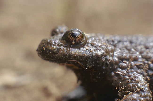
A close-up profile view of a yellow-bellied toad with textured, warty, dark-colored skin and large, dark, heart-shaped pupils.
A close-up view of a yellow-bellied toad, a protected species found in the Adelegg region.

Adelegg history and protected-area timeline

The recognition of the Adelegg as a site of European conservation importance dates back to 2005, when the Regierungspräsidium Tübingen formally proposed the area as part of Germany's contribution to the Natura 2000 network under the EU Habitats Directive. Following a multi-year evaluation process, the protected status was solidified through a decree of the Regierungspräsidium Tübingen dated 5 November 2018, designating the Adelegg as a Gebiet von gemeinschaftlicher Bedeutung (Site of Community Importance). The decree entered into force on 11 January 2019, formally establishing the protected area under its current configuration.

The management of the site is shared with the surrounding Vogelschutzgebiet Adelegg, for which a joint management plan was prepared under the direction of the Regierungspräsidium Tübingen by the Büro ARVE Arbeitsgemeinschaft Vegetation. This plan, finalized in September 2014, predates the formal designation of the FFH site itself and provided the framework for the conservation objectives that would later be legally codified. The alignment of the FFH area with the bird protection zone reflects the broader European emphasis on integrated protection of both habitats and species.

Adelegg landscape and geographic character

The landscape of the Adelegg is shaped by an alpine-influenced, predominantly forested ridge that rises prominently within the otherwise gentler Westallgäuer Hügelland. Topographically, the ridge forms a long, elevated backbone, broken by deep, narrow ravines and valleys that descend sharply from the higher slopes. These incised landforms, referred to locally as Tobel, give the protected area a striking vertical relief and create a varied mosaic of microclimates within a relatively small geographic footprint.

On the steep slopes, the terrain transitions into classic beech and mixed forest habitats, while on the higher elevations more open landscapes dominated by high pastures and nutrient-poor grassland take over. This juxtaposition of closed forest in the valleys and open grassland on the ridge tops mirrors traditional patterns of land use in the Allgäu, where centuries of grazing have shaped both the vegetation and the cultural landscape. The result is a protected area that combines dramatic natural landforms with the visible imprint of long-standing human presence on the land.
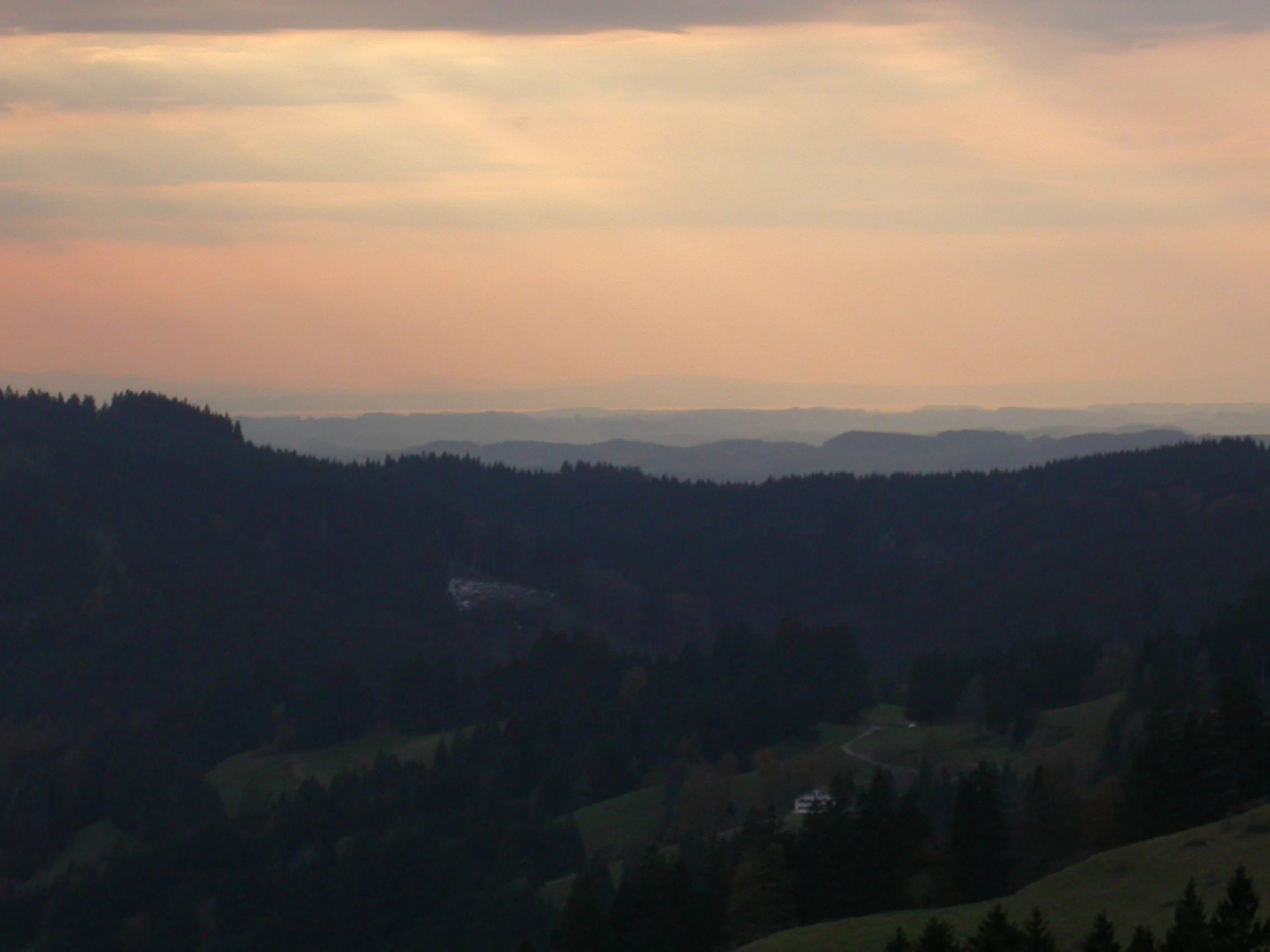
A wide, elevated landscape view featuring layers of forested ridgelines receding into a soft, hazy distance under a warm-toned sunset sky.
A sunset view from the Kreuzleshoehe in the Adelegg, looking out toward the distant hazy horizon.

Adelegg ecosystems, habitats, and plant life

Ecologically, the Adelegg is defined by the remarkable variety of habitat types it conserves within its twelve sub-areas. Forest habitats dominate, particularly the Waldmeister-Buchenwald (Galium odoratum beech forest) and the orchid-rich Cephalanthero-Fagion beech forests, which reflect the calcareous influence in parts of the ridge. The ravines support slope and gorge mixed forests of the Tilio-Acerion type, as well as alder-ash-willow floodplain forests along the watercourses.

Beyond the woodlands, the site protects an unusually broad spectrum of open and semi-open habitats, including species-rich montane Nardus grasslands on silicate soils, hay meadows of both lowland and montane types, moist tall herb communities, and calcareous spring fens with tufa formation. Rocky habitats are represented by calcareous scree slopes and limestone cliffs with crevice vegetation. Aquatic features round out the ecological profile, including nutrient-rich natural lakes, alpine rivers bordered by lavender willow shrubs, and lowland to montane flowing waters with characteristic Ranunculus vegetation.

Adelegg wildlife and species highlights

The species inventory of the Adelegg reflects the diversity of its habitats, with notable records of several species of community interest under the EU Habitats Directive. Aquatic and semi-aquatic fauna include the bullhead (Cottus gobio), a small freshwater fish typical of well-oxygenated streams, and the Eurasian beaver (Castor fiber), whose presence indicates healthy riparian forest along the watercourses. The yellow-bellied toad (Bombina variegata) represents the site's amphibian interest, likely benefitting from the combination of small pools, seeps, and structurally complex valley terrain.

The non-vascular flora includes several rare bryophyte species of conservation concern, namely the green broom moss (Dicranum viride), the green shield moss (Buxbaumia viridis), and Orthotrichum rogeri. Among the vascular plants, the lady's slipper orchid (Cypripedium calceolus) is one of the most notable species, a striking wild orchid of calcareous beech forests and open woodlands that adds particular botanical significance to the site. The overlap with the Vogelschutzgebiet further extends the wildlife profile, although specific bird species are documented in the management plan rather than the FFH listing itself.

Adelegg conservation status and protection priorities

From a conservation standpoint, the Adelegg serves as a critical node in the Natura 2000 network for the protection of forest, grassland, and aquatic habitat types typical of the pre-Alpine Westallgäu. Its value lies in the convergence of multiple Annex I habitat types within a comparatively small area, including beech forests, gorge woodlands, montane Nardus grasslands, calcareous fens, tufa springs, and dynamic river systems. Many of these habitats, such as orchid-rich beech forests and species-rich Nardus grasslands, are considered priorities under the Habitats Directive, reflecting their declining status across much of Europe.

The site's coordinated management with the adjacent Vogelschutzgebiet Adelegg creates an integrated protection framework for both habitats and species, including birds associated with the open and forested habitats of the ridge. The transboundary connection to the Bavarian Kürnacher Wald FFH site enhances genetic exchange and landscape connectivity, supporting long-term viability of species such as the beaver and forest-dwelling bryophytes. Management efforts, directed through the joint management plan prepared by the Regierungspräsidium Tübingen, focus on preserving habitat structure, maintaining traditional grassland use where appropriate, and protecting sensitive species populations from disturbance.

Adelegg cultural meaning and human context

The cultural dimension of the Adelegg is closely tied to the traditional land use patterns of the Allgäu, where the upper elevations of the ridge have historically been maintained as high pastures through seasonal grazing. These open, species-rich grasslands reflect centuries of interaction between local farming communities and the natural landscape, creating a semi-natural environment that supports both biodiversity and regional identity.

The communities of Isny im Allgäu and Leutkirch im Allgäu, whose municipal territories include the protected area, have long-standing relationships with the Adelegg as both a livelihood resource and a defining local landmark. The deep ravines and forest-covered flanks of the ridge have historically influenced settlement patterns, with villages and farmsteads concentrated on the gentler lower slopes and valley floors. This blend of natural and cultural landscape values reinforces the importance of the Adelegg not only as a European conservation site but also as a meaningful element of regional heritage.

Top sights and standout views in Adelegg

The Adelegg combines dramatic alpine-influenced topography with an exceptionally dense concentration of protected habitat types, making it a small but ecologically significant Natura 2000 site. Among its most distinctive features are the deep Tobel ravines, which shelter slope and gorge mixed forests, and the high-elevation Nardus grasslands that cap the ridge.

Additional highlights include the presence of priority species such as the lady's slipper orchid, the Eurasian beaver, the yellow-bellied toad, and rare bryophytes, alongside its seamless integration with the Vogelschutzgebiet Adelegg and connection to the Bavarian Kürnacher Wald. Together, these qualities position the Adelegg as a representative example of the rich, pre-Alpine forest and grassland mosaic of the Westallgäu.

Best time to visit Adelegg

The Adelegg can be appreciated across much of the year, though late spring and early summer tend to bring out the most characteristic features of the landscape. During this period, the high-pasture grasslands reach their peak flowering, the orchid-rich beech forests are at their most lush, and forest trails are typically accessible under drier ground conditions. The Tobel ravines remain cool and shaded through the warmer months, offering pleasant walking conditions even in summer.

Autumn brings its own appeal, with the beech forests displaying notable color change and a quieter atmosphere in the higher elevations. Winter conditions in the Allgäu can be cold and snowy, which may limit access to some of the steeper terrain but also lend the ridge a more austere, alpine character. For those interested in specific seasonal phenomena such as wildflower displays or autumn foliage, late spring through mid-autumn generally offers the most rewarding experience of the protected area's character.

Monthly climate preview

Long term temperature and precipitation cycles recorded at representative coordinates

Adelegg Climate Normals and Measured Monthly Weather Patterns

Recorded measurements for Adelegg reveal a sustained annual rhythm of average temperatures and monthly precipitation values based on historical data. Examining the complete twelve month profile provides deeper insight into long term climatological variations across the protected terrain.
Annual mean7 °C
-3 °C16 °C
Jan-3°
Feb-2°
Mar
Apr
May11°
Jun14°
Jul16°
Aug16°
Sep12°
Oct
Nov
Dec-2°
Warmest month
July

16.2 °C

Coolest month
January

-2.8 °C

Wettest month
June

5.4 mm/day

Driest month
February

2.7 mm/day

Park location guide

Geography guide, regional context, and park location map for Adelegg

Adelegg park geography, regions, and map view in Germany

Understand where Adelegg sits in Germany through a broader geographic reading of the surrounding landscape, nearby location context, and its mapped position within the national park landscape.

How Adelegg fits into Germany

Germany is a federal republic in Western and Central Europe with a population of over 83 million across sixteen constituent states. It is Europe's largest economy by nominal GDP and a major global exporter and importer. The capital is Berlin, and the country borders Denmark, Poland, Czech Republic, Austria, Switzerland, France, Luxembourg, Belgium, and the Netherlands.

Wider geography shaping Adelegg in Germany

Germany is located in Western and Central Europe, spanning 357,022 km². It borders Denmark to the north, Poland and the Czech Republic to the east, Austria and Switzerland to the south, and France, Luxembourg, Belgium, and the Netherlands to the west. The country has coastlines on the Baltic Sea and North Sea to the north, with the Alps located in the southern region.

Map view of Adelegg

Use this park location map to pinpoint Adelegg in Germany, understand its exact geographic position, and read its mapped placement within the surrounding landscape more clearly.

Pigeon | © OpenStreetMap contributors

Location context for Adelegg

Baden-Württemberg
Recorded earthquake history

Browse the Historical Catalogue of Recorded Earthquakes Near the Adelegg

Review documented seismic records and epicentre data associated with the Adelegg. This structured collection from MoriAtlas allows for a clear examination of historical event magnitudes and distances, providing a factual baseline for understanding seismic activity patterns around this protected region.

Adelegg Earthquake History

Catalogued events

24 events

Strongest magnitude

Magnitude 4.7

Most recent event

Oct 15, 2007

This history includes earthquakes recorded inside the park or within 50 km of its borders

Explore detailed imagery of forested ridges, deep ravines, and montane grasslands.

Adelegg Photos and Landscape Scenery: Visualizing Protected Habitats

Visual records capture the distinctive topography, steep slope forests, and rugged terrain that define the protected landscape. Examining these field photographs reveals the ecological mosaic and natural features characteristic of the regional ecosystem.

A close-up profile view of a yellow-bellied toad with textured, warty, dark-colored skin and large, dark, heart-shaped pupils.

Close-up view of two distinct yellow and maroon Lady's Slipper orchid flowers with prominent pouch-like labellums and dark, slender petals set against a soft, green, out-of-focus forest background.

A wide, elevated landscape view featuring layers of forested ridgelines receding into a soft, hazy distance under a warm-toned sunset sky.

Park atlas

Compare adjacent forest reserves, ridge habitats, and regional conservation areas.

Exploring Parks Near Adelegg and Surrounding Protected Landscapes

Browsing other protected areas near Adelegg reveals broader ecological patterns across the pre-Alpine forested ridge and surrounding Westallgäu terrain. Comparing adjacent nature reserves helps place local forest and grassland habitats into a wider regional conservation context.
A watercolor painting showing a panoramic view of a wetland with coniferous trees, soft green forest lines, and reddish bog vegetation against a pale background.
Nature reserveBaden-Württemberg
0.6 km away#1 closest

West

Bodenmöser und Hengelesweiher Nature Reserve: Mapped Geography and Protected Wetland Atlas

A diverse mosaic of peatlands and lakes in Westallgäu

Bodenmöser und Hengelesweiher represents a significant conservation network in southwestern Germany. This detailed view covers the distribution of calcareous fens, raised bogs, and dark-water pools that characterize the pre-Alpine hill landscape. Learn about the geographic configuration of this protected site as it bridges nutrient-poor lake ecosystems with surrounding alder woodlands and wet meadow corridors near Isny im Allgäu.

Area
7.59 km²
Established
2019
A horizontal watercolor illustration depicting a soft, atmospheric landscape with marshy ground, scattered evergreen trees, and distant hills.
Nature reserveLandkreis Oberallgäu
About 6.9 km away#2 closest

Southeast

Schönleitenmoos im Wierlinger Forst Protected Nature Reserve and Allgäu Bog Landscape

Raised bog geography on the Rhine-Danube watershed in Germany.

Schönleitenmoos im Wierlinger Forst is a compact nature reserve characterized by its well-preserved raised bog sequence and post-glacial origins. This site in the Oberallgäu district is essential for studying peatland vegetation zones and the rare occurrence of the rust-leaved alpine rose outside the high Alps, offering a detailed perspective on Bavarian landscape formation.

Area
0.23 km²
Established
1960
Protected landscapeBaden-Württemberg
About 8.7 km away#3 closest

Northwest

Uferbewuchs der Eschach Protected Landscape and Riparian Corridor Map

Riparian conservation within the Riß-Aitrach-Platten of Baden-Württemberg

Tracing the protected linear riparian corridors of the Eschach stream, this area is a significant example of urban-edge conservation in Germany. It maintains continuous stream-bank vegetation through the Leutkirch municipal landscape, linking directly to broader floodplain habitats of the Aitrach river system through its glacial-plateau geographic setting.

Established
1953
IUCN
V
Watercolor illustration of a lush natural ravine with a small cascading waterfall, surrounded by green forest slopes and distant rolling hills.
Nature reserveBavaria
About 8.9 km away#4 closest

Southeast

Rohrbachtobel im Wirlinger Forst Nature Reserve and Bavarian Pre-Alpine Forest Geography

Mapped protected gorge landscapes and molasse geology in the Oberallgäu district

Rohrbachtobel im Wirlinger Forst offers a unique look at small-scale protected landscapes in Germany. This nature reserve features a dramatic stream-cut gorge and serves as a natural habitat for diverse plant species, including European yew and multiple orchid varieties, within the wider context of the Bavarian pre-Alpine forest zone.

Area
0.14 km²
Established
1959
Relief
Upland
Scope
Terrestrial
A soft, panoramic watercolor painting featuring green, rolling hills and a winding river or stream through a forested landscape against a bright, hazy sky.
Nature reserveBaden-Württemberg
19 km away#5 closest

Northwest

Altdorfer Wald Nature Reserve: Geographic Atlas and Protected Landscape Overview

Mire, spring, and forest ecosystems in Baden-Württemberg

The Altdorfer Wald nature reserve consolidates a significant network of watercourses, peatlands, and old-growth forest stands across the Upper Swabian Pre-Alpine hills. This protected area stands as a primary focal point for understanding the interplay between hydrological richness, calcareous deposits, and diverse temperate forest habitats within the regional geography of Baden-Württemberg.

Area
13.71 km²
Established
2019
Relief
Upland
Climate
Temperate
Nature reserveBavaria
About 21 km away#6 closest

South

Nagelfluhkette Nature Park: Mapping the Alpine Ridges and Conglomerate Landscapes

A cross-border nature reserve in the Bavarian Alps.

Nagelfluhkette Nature Park is defined by its dramatic vertical transitions and unique Nagelfluh conglomerate geology. This protected area connects valley wetlands like the Großer Alpsee with steep mountain summits along the Hochgrat ridge. The region serves as an essential example of integrated conservation, linking forests, high-altitude moorlands, and traditional alpine agricultural landscapes across the Bavarian and Vorarlberg border.

Area
480 km²
Established
2008
Relief
Mountain
Climate
Alpine
Watercolor painting of a tranquil wetland landscape with pine trees, grassy shorelines, and distant rolling hills against a soft background.
Nature reserveBaden-Württemberg
31 km away#7 closest

Northwest

Feuchtgebiete um Bad Schussenried: Protected Wetland Mosaic and Regional Geography

Nature reserve complex in the Upper Swabian hill country

Feuchtgebiete um Bad Schussenried is an essential European FFH site spanning seven protected sub-areas. The landscape encompasses a dense patchwork of lowland fens, alder forests, and kettle-hole lakes, representing the unique glacial terrain of Upper Swabia through its intricate peatland and spring mire systems.

Area
6.1 km²
Established
2019
A soft watercolor painting of a rolling landscape featuring a winding river, grassy plains, and distant hills in muted green, pink, and yellow tones.
Protected landscapeBodenseekreis
About 31 km away#8 closest

West

Spätwürmeiszeitliche Terrassen zwischen Burnau, Prestenberg, Vorderreute, Buch und Krumbach Geography

A protected landscape site in the Bodenseekreis district

Spätwürmeiszeitliche Terrassen zwischen Burnau, Prestenberg, Vorderreute, Buch und Krumbach is defined by its series of level river terraces resulting from Würm ice age glacial retreat. Spanning roughly 22 hectares near the Schwarzach river, the site remains a vital example of fluvioglacial geomorphology and regional landscape preservation within the pre-Alpine foreland.

Area
0.22 km²
Established
1963
Relief
Upland
Climate
Temperate

Common questions about visiting, size, designation, and location context for Adelegg

Adelegg FAQs for park facts, access, geography, and protected area context

Find quick answers about Adelegg, including protected-area facts, park geography, trail and visitor context, and how the park fits into its surrounding country and regional landscape.
MoriAtlas Explorer

Continue Your Protected Areas Search Across the Global Atlas

Deepen your exploration by continuing the structured search for national parks and protected areas worldwide. Utilize the comprehensive filtering capabilities to compare different conservation landscapes and refine your understanding of global park geography. Discover more about the distribution and characteristics of protected natural areas.

Global natural geography