Mori Atlas logo
Protected areaAguaragüe National Park and Integrated Management Natural Area

Discover the Serranía del Aguaragüe's unique mountain terrain and ecological boundaries.

Aguaragüe National Park and Integrated Management Natural Area: Protected Landscape Geography in Gran Chaco Province

(Parque Nacional y Área Natural de Manejo Integrado Serranía del Aguaragüe)

Aguaragüe National Park and Integrated Management Natural Area stands as a significant protected landscape in Bolivia's Gran Chaco Province, safeguarding the dramatic Serranía del Aguaragüe mountain range. This area represents a critical geographic and ecological transition zone where the distinctive Sub-Andean uplifts rise sharply from the surrounding Chaco lowlands. Users can explore the mapped boundaries and unique terrain of this protected zone, understanding its role in preserving the intersection of Andean Yungas forests and Dry Chaco ecosystems.

national parksBoliviamountain protected areasSub-Andean rangeYungas forestsDry Chaco

Aguaragüe National Park and Integrated Management Natural Area

Protected area

Park overview

Structured park overview, official facts, and landscape profile for Aguaragüe National Park and Integrated Management Natural Area

Aguaragüe National Park and Integrated Management Natural Area park facts, protected area profile, and essential visitor context

Review the core facts for Aguaragüe National Park and Integrated Management Natural Area, including designation, size, terrain, visitor scale, habitats, and operating context in one park-focused overview.

About Aguaragüe National Park and Integrated Management Natural Area

Aguaragüe National Park and Integrated Management Natural Area represents one of Bolivia's significant mountainous protected areas, established to conserve the unique ecosystems of the Serranía del Aguaragüe range in the country's southern region. The protected area occupies a distinctive geographic position as the easternmost major Sub-Andean range in Bolivia, forming a dramatic north-south ridgeline that rises prominently from the surrounding Chaco plain. This mountainous terrain creates a complex environmental gradient, with moist montane forests on the higher slopes transitioning into drier woodland and thorn forest at lower elevations. The park's creation in 2000 reflected growing recognition of the ecological importance of Bolivia's Yungas forests and the need to protect the transitional ecosystems where these forests meet the extensive Dry Chaco. The integrated management approach applied to a significant portion of the protected area acknowledges the presence of local communities and allows for sustainable resource use while maintaining core conservation objectives in the national park zone. This dual-zoning strategy represents a pragmatic response to the realities of conservation in inhabited landscapes, attempting to balance ecological protection with livelihood needs.

Quick facts and research context for Aguaragüe National Park and Integrated Management Natural Area

Aguaragüe National Park and Integrated Management Natural Area covers approximately 108,307 hectares, with 45,822 hectares designated as national park and 62,485 hectares as integrated management natural area. The protected area was established on April 20, 2000, and is administered by Bolivia's Servicio Nacional de Áreas Protegidas (SERNAP). Located in the Gran Chaco Province of Tarija Department in southern Bolivia, the park encompasses the entire Serranía del Aguaragüe, the easternmost significant Sub-Andean mountain range in the country. The area lies at the ecological transition between Southern Andean Yungas montane forests and the Dry Chaco ecoregion.

Protection and recognition

Documenting terrestrial protection frameworks and conservation management designations.

Protection Status of Aguaragüe National Park and Integrated Management Natural Area

Geographic records outline the terrestrial protection status and established management scope of Aguaragüe National Park and Integrated Management Natural Area. Verifying designated frameworks helps researchers and conservationists trace official boundaries, regional governance designations, and global conservation recognition markers.

Protection details

Protection scope
Terrestrial
Transboundary protection
No
Park context

Deeper park guide and search-rich context for Aguaragüe National Park and Integrated Management Natural Area

Aguaragüe National Park and Integrated Management Natural Area history, landscape, wildlife, and travel context

Explore Aguaragüe National Park and Integrated Management Natural Area through its history, landscape character, ecosystems, wildlife, conservation priorities, cultural context, and seasonal travel timing in a structured park guide built for atlas discovery and search intent.

Why Aguaragüe National Park and Integrated Management Natural Area stands out

Aguaragüe is best known for protecting the easternmost Sub-Andean mountain range in Bolivia, a dramatic landscape of forested ridges that rises sharply from the surrounding Chaco lowlands. The park is notable for spanning a critical ecological transition zone, where Southern Andean Yungas montane forests meet the Dry Chaco, creating a diversity of habitats within a relatively compact protected area. The Serranía del Aguaragüe itself forms a biogeographic island of cloud forest and montane woodland surrounded by arid lowland ecosystems, making it especially significant for conservation. The protected area's dual designation combining national park strict protection with integrated management natural area zoning also represents a thoughtful approach to balancing conservation with sustainable use in this mountainous frontier region.
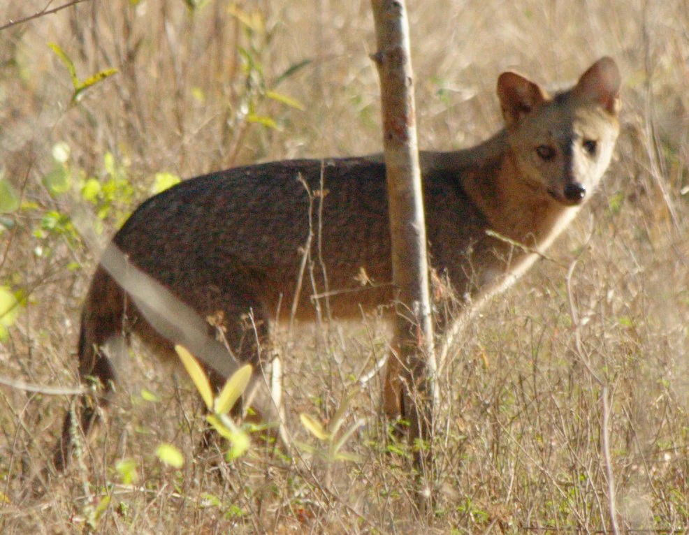
Crab-eating fox (Cerdocyon thous) in a grassy field with dry vegetation and a tree trunk
Crab-eating fox standing in dry grassland vegetation

Aguaragüe National Park and Integrated Management Natural Area history and protected-area timeline

Aguaragüe National Park and Integrated Management Natural Area was established on April 20, 2000, through Bolivia's national protected areas framework. The creation of this protected area reflected the growing commitment in the late 1990s and early 2000s to expand Bolivia's network of national parks and protected territories. The selection of the Serranía del Aguaragüe for protection recognized the ecological distinctiveness of this Sub-Andean range and its importance as a biodiversity corridor. Administration of the protected area was assigned to the Servicio Nacional de Áreas Protegidas (SERNAP), Bolivia's national protected areas service. The designation of portions of the area as an Integrated Management Natural Area rather than strict national park allowed for the recognition of existing land uses and community presence while establishing conservation zoning that permits sustainable activities in designated zones.

Aguaragüe National Park and Integrated Management Natural Area landscape and geographic character

The landscape of Aguaragüe National Park is dominated by the Serranía del Aguaragüe, a prominent north-south mountain range that forms the easternmost major Sub-Andean uplift in Bolivia. The range rises abruptly from the surrounding Chaco lowlands, creating dramatic topography with steep slopes, narrow valleys, and ridgeline crests. The elevation gradient from the lower foothills to the higher peaks creates significant variation in terrain, vegetation, and microclimate. Rock outcrops and cliff faces characterize portions of the steeper terrain, while the valleys below support more developed soils and denser forest cover. The range acts as a barrier to moisture-laden winds from the east, creating moist conditions on its upper slopes that support cloud forest development, while the western rain shadow effects contribute to the transitional nature of the lower elevation vegetation.

Aguaragüe National Park and Integrated Management Natural Area ecosystems, habitats, and plant life

The ecological character of Aguaragüe is defined by its position at the intersection of two major Neotropical biomes. The Southern Andean Yungas ecoregion dominates the higher elevations and eastern-facing slopes, characterized by montane evergreen forests, cloud forest formations, and high biodiversity. These forests receive significant moisture from easterly winds and support a rich assemblage of plant and animal species adapted to humid mountain conditions. In the lower portions and western slopes, the Dry Chaco ecoregion extends into the park, bringing drier conditions, thorn forest, and xerophytic vegetation. This blending of Yungas and Dry Chaco ecosystems within a single protected area creates unusual ecological diversity and provides habitat for species from both biomes. The montane forests of the Yungas are recognized as a biodiversity hotspot, and the protection of these forests within Aguaragüe contributes to the conservation of this threatened ecosystem.

Aguaragüe National Park and Integrated Management Natural Area wildlife and species highlights

The wildlife of Aguaragüe reflects the park's position at the ecological crossroads between Andean and Chaco faunas. The montane forest environments support species characteristic of the Yungas, while the lower elevation woodlands contain species more typical of the Dry Chaco. The presence of the crab-eating fox (Cerdocyon thousand) in the park is documented through photographic records, indicating that this canid species occupies the transitional environments within the protected area. The diverse habitats created by the elevation gradient and the blend of forest types support a range of vertebrate species, though detailed species inventories for the park are limited in the available source material. The protected status of the Serranía del Aguaragüe provides important habitat continuity for species requiring intact forest environments along the Sub-Andean corridor.

Aguaragüe National Park and Integrated Management Natural Area conservation status and protection priorities

Aguaragüe National Park and Integrated Management Natural Area contributes significantly to Bolivia's protected areas network by conserving a unique mountain ecosystem that would otherwise face pressure from logging, agriculture, and grazing. The protection of the Serranía del Aguaragüe preserves critical habitat within the Southern Andean Yungas, an ecoregion recognized for its high endemism and conservation importance. The integrated management approach applied to much of the protected area represents a practical conservation model that attempts to balance strict protection with sustainable use, recognizing that many mountainous landscapes have historical human presence. The park's position at the eastern edge of the Sub-Andean system means it serves as an important conservation node in the broader network of protected areas that follow the Andean mountain chain, supporting connectivity for species that require elevational migration or expanded ranges.

Aguaragüe National Park and Integrated Management Natural Area cultural meaning and human context

The Aguaragüe protected area exists within a region of Tarija Department that has historical human presence and ongoing land use. The integrated management natural area designation within the park reflects the practical reality of community presence and traditional land use practices in portions of the territory. The Gran Chaco Province where the park is located has been inhabited by various communities whose livelihoods have historically depended on the surrounding lands. While the national park zone receives stricter protection, the broader protected area framework attempts to accommodate both conservation objectives and sustainable community activities.

Top sights and standout views in Aguaragüe National Park and Integrated Management Natural Area

The defining highlight of Aguaragüe is its dramatic mountain landscape rising from the Chaco lowlands, protecting the easternmost major Sub-Andean range in Bolivia. The park's unique ecological position at the transition between Southern Andean Yungas montane forests and Dry Chaco creates unusual biodiversity within a single protected area. The dual-zoned approach combining strict national park protection with integrated management natural area provides a model for balancing conservation with sustainable use. The Serranía del Aguaragüe forms a biogeographic island of humid forest surrounded by arid lowlands, making it especially significant for endemic species and ecological study.

Best time to visit Aguaragüe National Park and Integrated Management Natural Area

The best time to visit Aguaragüe National Park would typically be during the dry season months from May to October, when visitor access is easier and trail conditions are more favorable. The park's subtropical mountain environment experiences wet and dry seasons, with the wet season from November to April bringing heavier rainfall that can affect road access and trail usability. Visiting during the dry season offers clearer views from the ridgelines and more comfortable conditions for hiking and exploration. The higher elevations may experience cooler temperatures year-round due to the mountain environment.
Monthly climate preview

Analyze thirty-year monthly temperature ranges and precipitation trends across the annual cycle.

Aguaragüe National Park and Integrated Management Natural Area Climate Normals

Long-term records at a representative elevation of 924 meters show a distinct cycle where warm, wet months transition to drier periods with cooler minimum temperatures. Accessing the complete weather by month dataset provides detailed monthly averages for temperature extremes and daily precipitation to help map the region's climate trends.
Annual mean22 °C
17 °C25 °C
Jan25°
Feb24°
Mar23°
Apr21°
May18°
Jun17°
Jul17°
Aug19°
Sep22°
Oct24°
Nov25°
Dec25°
Warmest month
December

25.2 °C

Coolest month
July

16.7 °C

Wettest month
February

6 mm/day

Driest month
July

0.7 mm/day

Park location guide

Geography guide, regional context, and park location map for Aguaragüe National Park and Integrated Management Natural Area

Aguaragüe National Park and Integrated Management Natural Area park geography, regions, and map view in Bolivia

Understand where Aguaragüe National Park and Integrated Management Natural Area sits in Bolivia through a broader geographic reading of the surrounding landscape, nearby location context, and its mapped position within the national park landscape.

How Aguaragüe National Park and Integrated Management Natural Area fits into Bolivia

Bolivia, officially the Plurinational State of Bolivia, is a landlocked country in central South America. It features diverse geography including the Andean mountain range, Amazonian plains, Gran Chaco, and the Pantanal wetland. The country has a population of approximately 11.4 million and is administratively divided into nine departments, with La Paz as the seat of government and Sucre as the constitutional capital.

Wider geography shaping Aguaragüe National Park and Integrated Management Natural Area in Bolivia

Bolivia is located in central South America, bordered by Brazil to the north and east, Paraguay to the southeast, Argentina to the south, Chile to the southwest, and Peru to the west. The country is divided between a western Andean region and tropical lowlands to the east and north. It includes the Amazonian plain, Gran Chaco, temperate valleys, the high-altitude Altiplano plateau, and part of the Pantanal wetland along its eastern border.

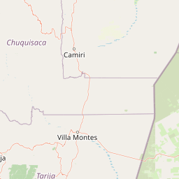
Map view of Aguaragüe National Park and Integrated Management Natural Area

Use this park location map to pinpoint Aguaragüe National Park and Integrated Management Natural Area in Bolivia, understand its exact geographic position, and read its mapped placement within the surrounding landscape more clearly.

Pigeon | © OpenStreetMap contributors

Location context for Aguaragüe National Park and Integrated Management Natural Area

Gran Chaco ProvinceTarija Department

Discover the visual identity of Bolivia's easternmost Sub-Andean range, from Yungas forests to Dry Chaco habitats.

Aguaragüe National Park and Integrated Management Natural Area: Landscape Photos and Chaco Scenery

Explore the diverse landscapes and distinct terrain of Aguaragüe National Park and Integrated Management Natural Area through a curated collection of images. These protected area photos showcase the dramatic mountain ranges, forested slopes, and ecological transition zones where Andean Yungas meet Dry Chaco, offering visual context for its unique conservation importance.

Crab-eating fox (Cerdocyon thous) in a grassy field with dry vegetation and a tree trunk

Park atlas

Explore the geographic context of Aguaragüe National Park and Integrated Management Natural Area within Bolivia's diverse protected estate.

Find Nearby National Parks and Protected Areas Similar to Aguaragüe National Park and Integrated Management Natural Area

Continue your park exploration by browsing national parks and protected areas near Aguaragüe National Park and Integrated Management Natural Area in Bolivia's Sub-Andean range. Compare their mapped geography and conservation landscapes to understand the regional spread of protected areas across the Gran Chaco and Yungas transition zones.
Wildlife reserveTarija
About 94 km away#1 closest

Southwest

Reserva nacional de flora y fauna de Tariquía: Atlas and Geographic Protected Area Overview

Montane cloud forest and subandean river valleys in Tarija

This wildlife reserve preserves the most intact stands of Yungas Tucumano-Boliviano forest in Bolivia. Featuring a dramatic vertical zonation from foothill selva to high-elevation pine woodlands, the area serves as a primary hub for ecological research and conservation in the rugged landscapes of Tarija near the Argentine border.

Area
2,468.7 km²
Established
1989
Relief
Mountain
Climate
Subtropical
Nature reserveDepartamento de Tarija
About 118 km away#2 closest

East

Reserva natural El Corbalán: Gran Chaco Protected Landscape and Regional Geography

A private nature reserve in Tarija Department, Bolivia.

Spanning the dry plains of the Chaco Boreal, Reserva natural El Corbalán provides essential protection for a representative sample of South American dry forest. The terrain, characterized by sparse thorny woodlands and flat lowland scrub, serves as a crucial habitat refuge. This resource offers insights into the unique ecological structure and mapped boundaries of one of Bolivia's most significant private conservation initiatives.

Area
47.78 km²
Established
1996
Relief
Lowland
Water
Minor water
Natural monumentSanta Cruz
About 125 km away#3 closest

North

Monumento natural municipal Muela del Diablo: Protected Area Geography and Landscape Context

Regional mapping of the Chaco plain and serranías.

The Muela del Diablo natural monument serves as an essential ecological landmark, protecting key aquifer recharge zones within the Santa Cruz department. This summary focuses on the topography of the peak and its function within the Gran Chaco ecoregion, offering a detailed perspective on the site's environmental geography and historical landscape significance.

Area
50.99 km²
Established
2009
Relief
Mountain
Climate
Subtropical
Biosphere reserveBolivia
About 136 km away#4 closest

West

Reserva Biológica de la Cordillera de Sama: Protected Mountain Landscapes of Southern Bolivia

High-Andean biosphere reserve featuring lagoons, dunes, and ancient pathways.

Reserva Biológica de la Cordillera de Sama encompasses a vast elevation range from dry inter-Andean valleys to the 4,700-meter peaks of the Cordillera Oriental. This reserve protects the endorheic Tajzara basin, where seasonal lagoons and sand dunes contrast with relict forests and steep mountain ravines. Its geography offers a complex mosaic of ecosystems, providing essential water sources and specialized habitat for endemic fauna within the southern Bolivian highlands.

Area
1,085 km²
Established
1991
Relief
Mountain
Climate
Alpine
National parkArgentina
About 139 km away#5 closest

Southwest

Baritú National Park National Park: Mapped Protected Landscapes in Argentina's Geography

Understand the natural terrain and geographic setting of this Argentinian park.

Baritú National Park represents a distinct national park entity within Argentina, crucial for understanding the country's protected landscapes and regional geography. This page provides specific atlas-level detail on its mapped boundaries and the surrounding natural terrain. Explore Baritú National Park as a key geographic feature contributing to the broader understanding of conservation areas across South America, grounded in factual, map-oriented discovery.

Area
720 km²
Established
1974
IUCN
II
Relief
Mountain
Protected landscapeTarija
About 146 km away#6 closest

West

Parque natural y área de manejo integrado El Cardón: Geography and Protected Area Atlas

High-altitude puna landscapes and cactus diversity in Tarija, Bolivia.

Spanning the high-altitude plateaus of southern Bolivia, this protected area features a unique mosaic of arid terrain, specialized cactus ecosystems, and vital wildlife corridors. The landscape provides a deep look into the puna and pre-puna geography of the Tarija department, including significant archaeological sites and thriving populations of wild vicuñas within a dramatic, high-elevation Andean environment.

Area
300.56 km²
Established
2003
Relief
Mountain
Climate
Arid
Wildlife reserveTarija Department
About 154 km away#7 closest

West

Tajzara Wildlife Reserve: Geographic and Landscape Overview of the Tarija Basin

High-altitude wetlands and saline lagoons in the Bolivian Andes

Tajzara Wildlife Reserve stands as a critical high-altitude wetland complex within the Tarija Department. This protected landscape sustains life across saline lake beds, seasonal pools, and marshy margins, functioning as a vital refuge for migratory waders and flamingo populations in the harsh, arid climate of the Bolivian Altiplano.

Area
13 km²
Established
1999
Relief
Highland
Climate
Alpine
Protected areaPotosí
About 210 km away#8 closest

West

Pampa Tholar de las Vicuñas: Protected Andean Puna Landscapes and Geographic Overview

Integrated management area and high-altitude habitat in Potosí, Bolivia.

Pampa Tholar de las Vicuñas covers nearly 60,000 hectares of arid puna in the municipality of Villazón, representing a key intersection of biodiversity and local pastoral traditions. The area features a complex mosaic of piedmont slopes, rolling foothills, and seasonal water networks that provide essential habitat for the Andean condor and large vicuña populations. This protected landscape offers a unique look at high-altitude land management in the transitional zone between the Altiplano and the Eastern Cordillera.

Area
584.8 km²
Established
2018
Relief
Highland
Climate
Arid

Common questions about visiting, size, designation, and location context for Aguaragüe National Park and Integrated Management Natural Area

Aguaragüe National Park and Integrated Management Natural Area FAQs for park facts, access, geography, and protected area context

Find quick answers about Aguaragüe National Park and Integrated Management Natural Area, including protected-area facts, park geography, trail and visitor context, and how the park fits into its surrounding country and regional landscape.
MoriAtlas Explorer

Continue Your Protected Areas Search Across the Global Atlas

Deepen your exploration by continuing the structured search for national parks and protected areas worldwide. Utilize the comprehensive filtering capabilities to compare different conservation landscapes and refine your understanding of global park geography. Discover more about the distribution and characteristics of protected natural areas.

Global natural geography