

Mori Atlas logo
Nature reserveNaturschutzgebiet Ahauser Klippen und Stausee

A dense refugial network of limestone cliffs, reservoir waters, and protected forest habitats within the Sauerland region.

Naturschutzgebiet Ahauser Klippen und Stausee: Mapping the Calcareous Landscapes of North Rhine-Westphalia

The Naturschutzgebiet Ahauser Klippen und Stausee represents a highly concentrated protected-area complex within the Attendorn-Elsper limestone basin. This reserve features some of the most significant natural cliff biotopes in the Olpe district, interlocked with dry-warm forests and vital waterbird habitats. The landscape demonstrates a tightly textured transition from steep carbonate rock formations to shaded ravine woodlands and reservoir edges.

nature reservecalcareous cliffslimestone forestorchid beech forestravine forestreservoir

Naturschutzgebiet Ahauser Klippen und Stausee

Nature reserve

Park overview

Structured park overview, official facts, and landscape profile for Ahauser Klippen und Stausee Nature Reserve

Ahauser Klippen und Stausee Nature Reserve park facts, protected area profile, and essential visitor context

Review the core facts for Ahauser Klippen und Stausee Nature Reserve, including designation, size, terrain, visitor scale, habitats, and operating context in one park-focused overview.

About Ahauser Klippen und Stausee Nature Reserve

Ahauser Klippen und Stausee sits in the southern Sauerland, in a part of the Attendorn-Elsper limestone basin defined by Massenkalk geology. This carbonate substrate underlies the reserve and shapes both its dramatic cliffs and its unusual forest vegetation. The nature reserve occupies land in both the town of Attendorn and the municipality of Finnentrop, with the majority of the area belonging to Finnentrop, and is divided into two sections by the L 539 regional road.

Despite its small size, the reserve compresses a striking variety of habitat types. The Ahauser Klippen cliffs rise as some of the highest natural rock biotopes in the Olpe district, their fissures supporting specialized moss and plant communities. Below and around the cliffs, the forest cover includes winter-lime and hornbeam scree woodland, orchid-rich calcareous beech forest, woodruff beech forest, and ravine and slope mixed forests that are extremely rare in this natural region. These woodland communities interlock tightly with drier, warmer forest types in patterns that depend directly on the underlying limestone.

The Ahauser Stausee reservoir is the second ecological anchor of the reserve. Sections of the reservoir fall within the protected area, and the shallow-water zone serves as a significant resting area for waterbirds in the Sauerland, complementing the nearby Gilberginsel reserve on the Bigge reservoir about six kilometers away. The land management approach deliberately avoids any forestry use in the cliff habitats and preserves quiet buffers around the reservoir so that both rock-forest refuges and waterbird resting zones remain functional. The site has been formally protected since 2003 and is integrated into the larger FFH area 'Kalkbuchenwälder, Kalkhalbtrockenrasen und -felsen südlich Finnentrop'.

Quick facts and research context for Ahauser Klippen und Stausee Nature Reserve

Ahauser Klippen und Stausee is a nature reserve located in the Attendorn and Finnentrop municipalities within the Olpe district of North Rhine-Westphalia. It covers a compact, ecologically dense area of under 24 hectares, designated in 2003 and classified as an IUCN Category IV Habitat/Species Management Area with the official code OE-019. The reserve is split visually by a regional road into two sections and combines high carbonate cliffs, a range of calcareous beech and ravine forest types, and a portion of the Ahauser Stausee reservoir.

Protection and recognition

Documented terrestrial boundary scope and verified global database indexing

Naturschutzgebiet Ahauser Klippen und Stausee Protection Status and Records

Terrestrial protection status for Naturschutzgebiet Ahauser Klippen und Stausee compiles verified administrative records without imported international designations. Systematic database indexing tracks boundary management scope and official conservation baseline entries.

Protection details

Protection scope
Terrestrial
Transboundary protection
No
WDPA ID
318083
Park context

Deeper park guide and search-rich context for Ahauser Klippen und Stausee Nature Reserve

Ahauser Klippen und Stausee Nature Reserve history, landscape, wildlife, and travel context

Explore Ahauser Klippen und Stausee Nature Reserve through its history, landscape character, ecosystems, wildlife, conservation priorities, cultural context, and seasonal travel timing in a structured park guide built for atlas discovery and search intent.

Why Ahauser Klippen und Stausee Nature Reserve stands out

The reserve is best known for its concentration of calcareous cliff and forest biotopes within the Attendorn-Elsper limestone basin. The Ahauser Klippen cliffs are among the highest natural rock biotopes in the Olpe district and serve as a central element of the surrounding FFH calcareous landscape. It is also recognized for the ecological value of the Ahauser Stausee, whose shallow-water zone functions as an important resting and wintering area for waterbirds in the Sauerland. The pairing of dry-warm limestone forests with ravine and slope woodland, and the linkage of those terrestrial habitats with a quiet reservoir, gives the site a particularly compact and ecologically rich character for such a small area.
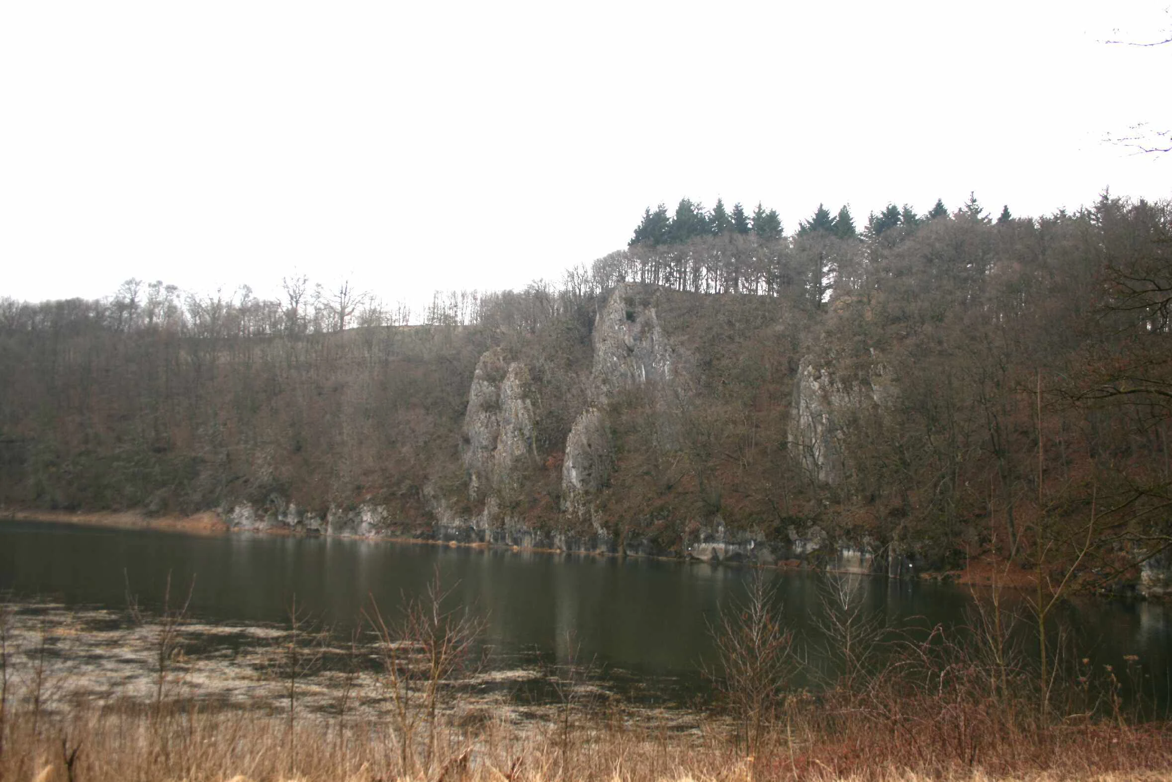
Ahauser Stausee
The Ahauser reservoir featuring a steep rock face

Ahauser Klippen und Stausee Nature Reserve history and protected-area timeline

The Ahauser Klippen und Stausee nature reserve was formally designated in 2003, bringing together cliff, forest, and reservoir habitats under a single protection framework within the Olpe district. The area had already been recognized for its ecological value through its inclusion as one of ten sub-areas of the larger Habitat (FFH) site dedicated to calcareous beech forests, calcareous semi-dry grasslands, and cliffs south of Finnentrop.

From the outset, the protection order emphasized not only the preservation of existing habitats but also their long-term development. The stated long-term goal for the forested portions of the reserve has been the development of a broadleaf forest landscape composed of typical native broadleaf community species, achieved in part by transforming even-aged stands into near-natural broadleaf forests with a mosaic of structural stages, including old-growth and deadwood phases.

Ahauser Klippen und Stausee Nature Reserve landscape and geographic character

The landscape of Ahauser Klippen und Stausee is defined by carbonate geology. The Massenkalk limestone forms the foundation for the Ahauser Klippen cliffs, which are among the most prominent natural rock formations in the Olpe district. These cliffs, with their fissure systems, anchor the southern edge of the reserve and transition sharply into forested slopes below.

The terrain is tightly textured. Steep rock faces give way to scree woodland, dry-warm forest stands, and shaded ravine and slope woodland within very short horizontal distances. Sections of the Ahauser Stausee reservoir border the reserve, creating an unusual interface between rocky terrestrial habitat and still water. The protected area itself is split into two sections by the L 539 regional road, yet the ecological character of the surrounding landscape remains continuous, with the reserve functioning as a core refugial biotop within the broader Attendorn-Elsper limestone basin.

Ahauser Klippen und Stausee Nature Reserve ecosystems, habitats, and plant life

Ecologically, Ahauser Klippen und Stausee is notable for the unusually tight ecological succession it contains. Within a compact area, the reserve moves from dry-warm and geogenic special biotopes at the cliffs into amphibious and limnic habitats at the reservoir, producing one of the most habitat-dense small reserves in the region.

The carbonate cliffs support fissure vegetation with rare moss and plant communities, while the surrounding forests contain a layered mix of woodland types. Winter-lime and hornbeam scree woodland occupies exposed positions; orchid-rich calcareous beech forest and woodruff beech forest occupy more typical slopes; and rare ravine and slope mixed forests occupy shaded, sheltered terrain. Several of these forest types are listed as priority or notable habitats under the EU Habitats Directive within the reserve.

The Ahauser Stausee itself adds a limnic dimension. Its shallow-water zones provide habitat for waterbirds, and the quiet buffer maintained around the reservoir allows both roosting and resting functions to persist. The overall ecological identity of the reserve is therefore one of close interlinking: rock-forest habitats above, amphibious margins, and open water all functioning as part of a single, compact ecological system.

Ahauser Klippen und Stausee Nature Reserve wildlife and species highlights

Wildlife at Ahauser Klippen und Stausee is shaped by the reserve's combination of cliffs, varied forest types, and reservoir habitat. The cliffs and their associated fissure vegetation support specialized moss and plant communities and provide shelter and nesting conditions for rock-associated fauna. The eagle owl (Bubo bubo) is documented as a breeding species in the reserve and is explicitly cited under the protection order as a key bird species linked to the EU Birds Directive.

The Ahauser Stausee portion of the reserve contributes a different wildlife character. Its shallow-water zone and quiet surroundings function as a significant resting and overwintering area for waterbirds in the Sauerland, complementing the role of the nearby Gilberginsel reserve on the Bigge reservoir. Together, the terrestrial and aquatic wildlife values of the reserve reflect its role as both a forest-cliff refuge and a waterbird resting area within the regional protected-area network.

Ahauser Klippen und Stausee Nature Reserve conservation status and protection priorities

Ahauser Klippen und Stausee was designated in 2003 as a Category IV Habitat/Species Management Area under the German nature reserve framework, with the official code OE-019. Its designation is justified on multiple grounds, including the protection of over regionally significant habitats and species, the safeguarding of Habitats Directive Annex I and Annex II biotopes and species, scientific and earth-historical reasons, and the rarity, special character, and outstanding beauty of the area.

Several habitats within the reserve are recognized under the EU Habitats Directive, including ravine and slope mixed forests as a priority habitat, orchid-rich calcareous beech forest, woodruff beech forest, and limestone cliffs with fissure vegetation. The eagle owl is the most prominent bird species explicitly protected under the Birds Directive within the site. Management explicitly avoids any forestry use in cliff habitats and maintains undisturbed buffer zones around the reservoir so that both forest-cliff refuges and waterbird roosting conditions remain intact. The reserve is also one of ten sub-areas of the larger FFH site 'Kalkbuchenwälder, Kalkhalbtrockenrasen und -felsen südlich Finnentrop'.

Top sights and standout views in Ahauser Klippen und Stausee Nature Reserve

Ahauser Klippen und Stausee is distinguished by the density and quality of its calcareous cliff and forest habitats packed into a small area, and by the unusual pairing of those rock-forest refuges with a reservoir that hosts waterbirds. The cliffs are among the highest natural rock biotopes in the Olpe district and stand as a central biotope element within the surrounding calcareous landscape of the Attendorn-Elsper basin.

The reserve's combination of priority habitats, breeding eagle owls, and an important waterbird resting zone gives it a conservation profile that is unusually broad for such a compact area. Its formal integration into the larger Habitats Directive landscape south of Finnentrop further reinforces its role as a key node within the regional network of calcareous protected sites.

Best time to visit Ahauser Klippen und Stausee Nature Reserve

The reserve's character is shaped more by ecological than seasonal contrasts, so timing depends largely on the kind of experience sought. Spring and early summer bring active birdlife around the reservoir, the breeding presence of the eagle owl in cliff terrain, and the most visibly fresh forest vegetation in the calcareous woodlands. Late spring and early summer can also be the most rewarding periods for observing the orchid-rich calcareous beech forest at its seasonal peak.

For quiet observation of waterbirds and a calm reservoir atmosphere, cooler months can also be appealing, when reservoir margins are used as resting areas by migratory and wintering waterfowl. As with any small protected area, disturbance should be minimized, and visits are generally best kept brief and low-impact so the reserve's refugial character is preserved.

Monthly climate preview

Long-term representative monthly temperature and precipitation patterns

Naturschutzgebiet Ahauser Klippen und Stausee Climate and Temperature Normals

Representative coordinate records outline the annual temperature range and precipitation averages measured across twelve distinct monthly intervals for Naturschutzgebiet Ahauser Klippen und Stausee. Complete multi-year climatology data provides a deeper monthly breakdown for examining long-term thermal and moisture trends.
Annual mean8 °C
-1 °C17 °C
Jan-1°
Feb
Mar
Apr
May12°
Jun15°
Jul17°
Aug17°
Sep13°
Oct
Nov
Dec
Warmest month
July

17.4 °C

Coolest month
January

-0.7 °C

Wettest month
December

3 mm/day

Driest month
April

1.8 mm/day

Park location guide

Geography guide, regional context, and park location map for Ahauser Klippen und Stausee Nature Reserve

Ahauser Klippen und Stausee Nature Reserve park geography, regions, and map view in Germany

Understand where Ahauser Klippen und Stausee Nature Reserve sits in Germany through a broader geographic reading of the surrounding landscape, nearby location context, and its mapped position within the national park landscape.

How Ahauser Klippen und Stausee Nature Reserve fits into Germany

Germany is a federal republic in Western and Central Europe with a population of over 83 million across sixteen constituent states. It is Europe's largest economy by nominal GDP and a major global exporter and importer. The capital is Berlin, and the country borders Denmark, Poland, Czech Republic, Austria, Switzerland, France, Luxembourg, Belgium, and the Netherlands.

Wider geography shaping Ahauser Klippen und Stausee Nature Reserve in Germany

Germany is located in Western and Central Europe, spanning 357,022 km². It borders Denmark to the north, Poland and the Czech Republic to the east, Austria and Switzerland to the south, and France, Luxembourg, Belgium, and the Netherlands to the west. The country has coastlines on the Baltic Sea and North Sea to the north, with the Alps located in the southern region.

Map view of Ahauser Klippen und Stausee Nature Reserve

Use this park location map to pinpoint Ahauser Klippen und Stausee Nature Reserve in Germany, understand its exact geographic position, and read its mapped placement within the surrounding landscape more clearly.

Pigeon | © OpenStreetMap contributors

Location context for Ahauser Klippen und Stausee Nature Reserve

North Rhine-Westphalia

Visualizing limestone cliffs, forest biotopes, and reservoir habitats

Naturschutzgebiet Ahauser Klippen und Stausee Photos and Landscapes

Visual records capture the steep limestone cliffs and calm reservoir waters defining the protected landscape of Naturschutzgebiet Ahauser Klippen und Stausee. Examining field photography reveals the compact ecological mosaic of dry-warm forests and rocky terrain spanning the regional basin.

Ahauser Stausee

Ahauser Klippen

Park atlas

Explore nearby protected areas and connected limestone landscapes across the Sauerland region.

Other Parks Near Naturschutzgebiet Ahauser Klippen und Stausee for Regional Comparison

Compare Naturschutzgebiet Ahauser Klippen und Stausee with other protected areas sharing similar calcareous geology and forest habitats. Expanding the search across nearby regional nature reserves reveals broader patterns in local conservation geography.
Nature reserveNorth Rhine-Westphalia
About 1.7 km away#1 closest

Northeast

Hohe Ley Nature Reserve: Limestone Cliffs and Forest Geography in North Rhine-Westphalia

Protected calcareous woodland and raptor breeding habitat

This nature reserve in the Sauerland region features a prominent limestone cliff and a complex mosaic of woodruff and wavy hair grass beech forests. As part of a larger European habitat network, the reserve supports rare dry grassland and ravine woodland communities. Its topography provides critical nesting sites for eagle owls and common kestrels, anchoring a valuable ecological corridor within the local landscape.

Area
0.498 km²
Established
1981
Nature reserveKreis Olpe
About 3.6 km away#2 closest

East

Wunderwäldchen Nature Reserve: Mapping Botanical Biodiversity in the District of Kreis Olpe

A cross-boundary woodland refuge in the Sauerland region

Wunderwäldchen is a protected nature reserve spanning the border of two municipalities in Kreis Olpe. This small beech and oak woodland serves as a critical botanical refuge, sustaining rare plant species on its carbonate-enriched soils. It remains a key example of how even minute, fragmented habitats provide essential ecological value within the densely managed landscapes of the Lenne valley.

Area
0.007 km²
Established
1981
IUCN
IV
Relief
Upland
Nature reserveNorth Rhine-Westphalia
About 6 km away#3 closest

Northwest

Heinrich-Bernhard-Höhle Nature Reserve and Karst Landscape in North Rhine-Westphalia

Examining the geology and protection status of the Sauerland karst system

The Heinrich-Bernhard-Höhle represents a unique convergence of conservation designations, functioning as a nature reserve, paleontological monument, and FFH habitat area. Centered on a 192-meter limestone cave network, the site preserves essential subterranean geological structures and surface beech forests within the North Rhine-Westphalia region.

Area
0 km²
Established
1934
Relief
Upland
Access
Highly restricted
Protected areaNordrhein-Westfalen
About 9.3 km away#4 closest

Southwest

Listertalsperre Reservoir and Protected Forest Landscape in North Rhine-Westphalia

Historic gravity dam and regional hydrologic landmark.

Explore the detailed geography of Listertalsperre, a unique reservoir site characterized by its historic stone masonry dam and role in the regional water supply. This protected area offers insight into the engineered landscapes of the Sauerland, featuring forest-covered ridges and specialized waterfowl habitats that define this segment of the regional watershed.

Area
1.68 km²
Established
1912
Relief
Upland
Climate
Temperate
Nature reserveKreis Olpe
About 9.6 km away#5 closest

South

Naturschutzgebiet Ahetal und Langes Siepen: Geography and Protected Area Overview

Nature reserve in the Rothaar foothills, Kreis Olpe

Covering the Ahe valley and its headwater catchment, this nature reserve is defined by its exceptionally dense concentration of seepage springs and near-natural brooks. The landscape transitions from shaded alder-lined seepage valleys into open, species-rich grassland, providing a critical refuge for local woodland species. As part of the Rothaarvorhöhen biotope network, it represents a significant, compact example of central upland stream valley geography.

Area
0.407 km²
Established
2020
Water
Major water bodies
Nature reserveNorth Rhine-Westphalia
About 13 km away#6 closest

Northwest

Naturschutzgebiet Oberes Elsetal: Protected Brook Valley Geography in North Rhine-Westphalia

Mapping riparian ecosystems and low mountain range stream habitats.

Naturschutzgebiet Oberes Elsetal offers a detailed look at the structural interplay between spring-fed brooks and adjacent marshy grasslands. This nature reserve in the Südsauerländer Bergland provides an instructive map of how riparian alder gallery woodland, oak-hornbeam forest, and wet meadow communities converge in a compact, highly specialized valley setting.

Area
0.053 km²
Established
1998
Relief
Upland
Scope
Terrestrial
Nature reserveKreis Olpe
About 14 km away#7 closest

South

Naturschutzgebiet Olpetal und Altenkleusheimer Bachtal: Protected Valley and Brook Geography

Riparian ecosystems in the Kreis Olpe district

Located in the Rothaar foothills, this nature reserve spans nearly 37 hectares of stream valleys and floodplain meadows. The protected landscape includes alder-lined watercourses, spring-fed wetlands, and diverse slope vegetation, serving as a core component of the regional biotope network in North Rhine-Westphalia.

Area
0.372 km²
Established
2020
Relief
Upland
Climate
Temperate
Nature reserveNordrhein-Westfalen
About 15 km away#8 closest

Northwest

Naturschutzgebiet Schlänke: Woodland Conservation in the Märkischer Kreis Region

Protected beech-forest terrain and spring-blooming flora

Spanning roughly 0.6 hectares, Naturschutzgebiet Schlänke is a focused nature reserve dedicated to the preservation of native deciduous woodland. The site occupies a north-facing slope, creating specific moisture conditions that sustain a notable population of spring snowflakes, marking it as a significant botanical patch within the broader forested landscape of Plettenberg.

Area
0.006 km²
Established
1985
Relief
Upland
Climate
Temperate

Common questions about visiting, size, designation, and location context for Ahauser Klippen und Stausee Nature Reserve

Ahauser Klippen und Stausee Nature Reserve FAQs for park facts, access, geography, and protected area context

Find quick answers about Ahauser Klippen und Stausee Nature Reserve, including protected-area facts, park geography, trail and visitor context, and how the park fits into its surrounding country and regional landscape.
MoriAtlas Explorer

Continue Your Protected Areas Search Across the Global Atlas

Deepen your exploration by continuing the structured search for national parks and protected areas worldwide. Utilize the comprehensive filtering capabilities to compare different conservation landscapes and refine your understanding of global park geography. Discover more about the distribution and characteristics of protected natural areas.

Global natural geography