Mori Atlas logo
Nature reserveVogelschutzgebiet Ahrgebirge

Mapped forest terrain and ridge geography within the Eifel mountain system

Vogelschutzgebiet Ahrgebirge Nature Reserve and Protected Woodland Landscape in North Rhine-Westphalia

(EU-Vogelschutzgebiet Ahrgebirge)

Vogelschutzgebiet Ahrgebirge represents a critical protected forest corridor within North Rhine-Westphalia, covering roughly 580 hectares of mid-elevation terrain. This nature reserve serves as an essential sanctuary for woodland birds, defined by its mix of mature beech and oak forests, near-natural stream valleys, and structurally complex forest edges that characterize this section of the Rhenish Slate Mountains.

bird sanctuaryEU Birds DirectiveNatura 2000mixed forestdeciduous forestbeech forest

Vogelschutzgebiet Ahrgebirge

Nature reserve

Park overview

Structured park overview, official facts, and landscape profile for Ahrgebirge Bird Sanctuary

Ahrgebirge Bird Sanctuary park facts, protected area profile, and essential visitor context

Review the core facts for Ahrgebirge Bird Sanctuary, including designation, size, terrain, visitor scale, habitats, and operating context in one park-focused overview.

About Ahrgebirge Bird Sanctuary

Ahrgebirge Bird Sanctuary is a European bird protection area in the Eifel region of western Germany, focused on the conservation of forest habitats and the bird species that depend on them. It lies on the North Rhine-Westphalian slope of the Ahrgebirge, a mid-elevation mountain ridge that runs between Bad Münstereifel in the north and Altenahr in the south and belongs to the broader Rhenish Slate Mountains. Although the sanctuary itself is only about 580 hectares in size, it forms an ecologically important component of a much larger forested landscape shared with the Rhineland-Palatinate side of the ridge.

The sanctuary was designated in 2004 under the EU Birds Directive, which obliges member states to protect the habitats of wild native bird species. In Germany, areas designated under this directive are implemented as European Bird Protection Areas, or Vogelschutzgebiete, and integrated into the Natura 2000 network. The Ahrgebirge site carries the code DE-5506-471 and is administered through the Cologne Government Region.

In terms of habitat, the area is overwhelmingly forested. Mixed forest accounts for roughly half of its surface, with planted conifer stands covering about a third, deciduous woodland a smaller share, and inland waters, settlements, and infrastructure making up the remainder. The terrain is shaped by a hilly to gently undulating relief, with streams and brooks flowing through near-natural channels. The vegetation includes acidic beech forests of the Luzulo-Fagetum type, mixed oak-hornbeam woodland of the Galio-Carpinetum type, and brook-side vegetation characteristic of lowland to montane river systems.

The sanctuary's ecological value lies in its relatively undisturbed forest interior, its high share of mature trees and deadwood, and the structural richness of its forest edges and stream corridors. These qualities support breeding populations of several specialist bird species, including the grey-headed woodpecker, middle spotted woodpecker, black woodpecker, and the regionally notable hazel grouse, as well as woodland raptors such as the red kite and wetland-associated species such as the black stork along the streams.

Quick facts and research context for Ahrgebirge Bird Sanctuary

The Ahrgebirge Bird Sanctuary lies in the Kreis Euskirchen district of North Rhine-Westphalia, in the southernmost part of the state along the boundary with Rhineland-Palatinate. It is designated as a European Bird Protection Area under the EU Birds Directive, with the official site code DE-5506-471, and was formally established through a 2004 ordinance by the Cologne Government Region.

The area is best understood as a forest-dominated bird sanctuary within the Ahrgebirge, a ridge of the Eifel that forms part of the Rhenish Slate Mountains. Mixed woodland, beech forest patches, and conifer plantations dominate the landscape, while small streams and brook valleys add habitat diversity. The sanctuary is recognized particularly for its importance to woodland-breeding birds of the central Eifel region.

Protection and recognition

Examine the documented conservation records and official protected area designations

Vogelschutzgebiet Ahrgebirge Protection Status and Natura 2000 Recognition

Vogelschutzgebiet Ahrgebirge maintains official documentation through recorded Natura 2000 designations and database listings. Review the verified protection status and international recognition sources associated with this protected landscape.
Park context

Deeper park guide and search-rich context for Ahrgebirge Bird Sanctuary

Ahrgebirge Bird Sanctuary history, landscape, wildlife, and travel context

Explore Ahrgebirge Bird Sanctuary through its history, landscape character, ecosystems, wildlife, conservation priorities, cultural context, and seasonal travel timing in a structured park guide built for atlas discovery and search intent.

Why Ahrgebirge Bird Sanctuary stands out

The sanctuary is best known for its large, near-natural deciduous and mixed forest complexes, which support breeding populations of several woodland birds that depend on old trees, deadwood, and quiet interior forest conditions. It has particular regional significance for the hazel grouse, whose occurrence in the Eifel area of Kreis Euskirchen is regarded as especially important. Beyond its forest character, the sanctuary is also valued for the way it protects a coherent block of the Ahrgebirge ridge on the North Rhine-Westphalian side of the state border, complementing protected forest areas across the regional boundary. The combination of mature beech and oak woodland, near-natural stream valleys, and richly structured forest edges gives the area its distinct bird-protection identity.
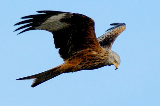
A Red Kite bird of prey soaring against a clear blue sky, showing its distinct forked tail and brown plumage.
A Red Kite in flight, a characteristic bird species of the Ahrgebirge region.

Ahrgebirge Bird Sanctuary history and protected-area timeline

The Ahrgebirge Bird Sanctuary was formally designated in 2004, when the Cologne Government Region issued the ordinance establishing it as a European Bird Protection Area under the EU Birds Directive. The designation was part of the broader process by which Germany identified and protected Special Protection Areas for birds across its federal states, contributing to the European Natura 2000 network.

The underlying motivation for the designation was ecological rather than political: the Ahrgebirge was identified as a forest landscape of significant value for woodland-breeding bird species, including the hazel grouse, which is of particular conservation concern in the Eifel region. By protecting the North Rhine-Westphalian portion of the ridge as part of this transboundary forest complex, the sanctuary effectively rounds out, or arrondiert, the protected area network on the German side of the state border with Rhineland-Palatinate.

Since its establishment, the sanctuary has functioned primarily as a regulatory and planning framework rather than a strictly fenced reserve. Its purpose is to safeguard habitat quality, guide sustainable forest management, maintain old trees and deadwood, and prevent fragmentation of the forest landscape, while also connecting with related nature reserves in the same valley systems.

Ahrgebirge Bird Sanctuary landscape and geographic character

The Ahrgebirge is a mid-elevation ridge of the Eifel, reaching just over 620 meters above sea level at its highest point and stretching roughly 25 kilometers along the border between North Rhine-Westphalia and Rhineland-Palatinate. It belongs to the Rhenish Slate Mountains, a varied upland region characterized by rounded ridges, deep valleys, and long-established woodland cover.

On the North Rhine-Westphalian side, the landscape within the sanctuary is shaped by gently rolling to hilly forest terrain. Stream valleys cut into the slopes, with near-natural brook channels flanked by alder and willow stands, wet flushes, and moist forest fringes. The slopes themselves are cloaked in beech-dominated deciduous forest, mixed woodland, and conifer plantations, with forest clearings, woodland edges, and small meadows breaking up the closed canopy in places.

The result is a quiet, structurally rich forest landscape where rocky outcrops, leaf litter, deadwood, and mossy stream banks create a varied microtopography. The visual character is one of dense, mature forest interlaced with narrow valleys, typical of the central Eifel woodland scenery.

Ahrgebirge Bird Sanctuary ecosystems, habitats, and plant life

Ecologically, the sanctuary belongs to the Ahreifel natural area of the central Eifel and exemplifies the transition zone between the more agricultural landscapes of the lower Ahr valley and the higher, more forested uplands. Forest is the dominant habitat, and the protection framework emphasizes the maintenance of near-natural woodland communities with their typical species composition and structure.

The habitat mosaic includes several distinct woodland types: acidic beech forest on the poorer soils, mixed oak-hornbeam forest on richer sites, planted spruce stands that contrast with the more natural deciduous character, and streamside woodland along the brooks draining the ridge. These habitats support a layered vegetation structure with a well-developed shrub layer, diverse herb layer, and a high proportion of old trees and deadwood, elements that are critical for many forest-specialist species.

Along the stream systems, small flushes, moist meadows, and wet woodland add a wetland dimension to an otherwise predominantly terrestrial protected area. While not large, these features are ecologically significant because they link the sanctuary's forests to the broader valley ecosystems of the Ahr and its tributaries.

Ahrgebirge Bird Sanctuary wildlife and species highlights

The sanctuary's wildlife significance centers on its breeding bird fauna, particularly the woodland species that depend on mature, structurally rich forests with old trees and deadwood. Several woodpecker species are among the key targets, including the grey-headed woodpecker, the middle spotted woodpecker, and the black woodpecker, all of which require old deciduous trees for nesting and feeding.

The hazel grouse is highlighted as a species of particular regional importance. Its occurrence in the Eifel area of Kreis Euskirchen is considered highly significant, and the sanctuary's quiet, well-structured mixed forests with dense undergrowth, small clearings, and broadleaf regeneration areas provide some of the most suitable local habitat for the species.

In addition, the sanctuary supports the red kite, which uses the forest edges and open countryside around the Ahrgebirge for hunting, and the black stork, which depends on quiet mature forests near clean, undisturbed streams. The kingfisher is associated with the dynamic brook and stream systems running through the protected area. Other species addressed in the conservation objectives include the red-backed shrike, which is associated with semi-open, bushy cultural landscapes on the edges of the forest.

Ahrgebirge Bird Sanctuary conservation status and protection priorities

From a conservation perspective, the Ahrgebirge Bird Sanctuary is significant as one of the forest-dominated Special Protection Areas that contribute to Germany's share of the European Natura 2000 network. Its designation reflects the recognition that many of Europe's woodland-breeding birds cannot be preserved by protecting individual trees or small woodland fragments; they require large, contiguous, structurally rich forest landscapes managed in ways that maintain habitat quality over the long term.

The core conservation objectives focus on preserving the diversity of habitats and the characteristic birdlife of the central Eifel, while encouraging the development of near-natural forest communities. Specific measures aim to maintain and increase the share of old trees and deadwood, prevent the fragmentation and isolation of suitable woodland, preserve sunny clearings, edges, and small structural features, and enhance the food supply available to forest birds.

For the hazel grouse, the conservation strategy emphasizes large, unfragmented, disturbance-poor forest areas with a rich understory, the reduction of conifer cover along streams in favor of broadleaf woodland, and the maintenance of suitable roosting and dusting sites. The sanctuary also contributes to broader landscape-level conservation by connecting with adjacent nature reserves, such as the Michelsbach, Ahbach, and Aulbach streams protection area and the Western Ahr Area nature reserve, which together form a more coherent protected landscape along the Ahr valley systems.

Top sights and standout views in Ahrgebirge Bird Sanctuary

The sanctuary's strongest qualities lie in its near-natural mixed and deciduous forests, its role as a refuge for the regionally significant hazel grouse, and its breeding habitat for several specialist woodpeckers such as the grey-headed, middle spotted, and black woodpecker. The extensive old trees and deadwood, the rich understory structure, and the near-natural stream corridors give the protected area much of its ecological character.

Equally important is its role in the broader Eifel conservation landscape. By protecting the North Rhine-Westphalian flank of the Ahrgebirge and connecting with neighboring nature reserves along the Ahr tributaries, the sanctuary helps maintain a continuous forest corridor across one of the most ecologically valuable ridges of the western Eifel.

Monthly climate preview

Long-term representative temperature and precipitation averages across twelve months

Vogelschutzgebiet Ahrgebirge Climate Normals and Monthly Weather Patterns

Vogelschutzgebiet Ahrgebirge records measured monthly temperature fluctuations alongside consistent precipitation averages derived from historical satellite data. Reviewing the complete twelve-month climatology provides deeper insight into the baseline environmental rhythm at this representative elevation.
Annual mean9 °C
0 °C18 °C
Jan
Feb
Mar
Apr
May12°
Jun15°
Jul18°
Aug18°
Sep14°
Oct
Nov
Dec
Warmest month
July

17.9 °C

Coolest month
January

0 °C

Wettest month
June

2.5 mm/day

Driest month
April

1.6 mm/day

Park location guide

Geography guide, regional context, and park location map for Ahrgebirge Bird Sanctuary

Ahrgebirge Bird Sanctuary park geography, regions, and map view in Germany

Understand where Ahrgebirge Bird Sanctuary sits in Germany through a broader geographic reading of the surrounding landscape, nearby location context, and its mapped position within the national park landscape.

How Ahrgebirge Bird Sanctuary fits into Germany

Germany is a federal republic in Western and Central Europe with a population of over 83 million across sixteen constituent states. It is Europe's largest economy by nominal GDP and a major global exporter and importer. The capital is Berlin, and the country borders Denmark, Poland, Czech Republic, Austria, Switzerland, France, Luxembourg, Belgium, and the Netherlands.

Wider geography shaping Ahrgebirge Bird Sanctuary in Germany

Germany is located in Western and Central Europe, spanning 357,022 km². It borders Denmark to the north, Poland and the Czech Republic to the east, Austria and Switzerland to the south, and France, Luxembourg, Belgium, and the Netherlands to the west. The country has coastlines on the Baltic Sea and North Sea to the north, with the Alps located in the southern region.

Map view of Ahrgebirge Bird Sanctuary

Use this park location map to pinpoint Ahrgebirge Bird Sanctuary in Germany, understand its exact geographic position, and read its mapped placement within the surrounding landscape more clearly.

Pigeon | © OpenStreetMap contributors

Location context for Ahrgebirge Bird Sanctuary

North Rhine-Westphalia
Recorded earthquake history

Review the Historical Earthquake Catalogue for Vogelschutzgebiet Ahrgebirge

Consult a structured record of seismic events detected in the vicinity of the Vogelschutzgebiet Ahrgebirge. This MoriAtlas dataset allows for the analysis of regional historical activity through mapped epicentre distances and associated magnitude values.

Vogelschutzgebiet Ahrgebirge Earthquake History

Catalogued events

31 events

Strongest magnitude

Magnitude 4.4

Most recent event

Apr 11, 2010

This history includes earthquakes recorded inside the park or within 50 km of its borders

Visual reference collection showcasing protected forest habitats and terrain

Vogelschutzgebiet Ahrgebirge Landscape and Scenery Photography

Photographic documentation reveals the dense mixed woodlands, mature beech stands, and quiet stream valleys that define the protected landscape. Visual research into these upland forest habitats provides a clearer understanding of the terrain supporting specialized regional bird populations.

A Red Kite bird of prey soaring against a clear blue sky, showing its distinct forked tail and brown plumage.

A black stork with a dark head and white belly standing in shallow water, with another out of focus bird in the background.

Park atlas

Compare adjacent Eifel forest reserves and connected regional landscapes

Other Parks Near Vogelschutzgebiet Ahrgebirge and Surrounding Protected Areas

Browsing other parks near Vogelschutzgebiet Ahrgebirge reveals connected forest terrain and protected upland ridges across the western Eifel region. Examining adjacent nature reserves provides deeper geographic context for woodland bird habitats and regional conservation corridors.
A horizontal watercolor illustration showing soft, rolling green hills, a background of distant purple mountains, and small clusters of pinkish trees.
Nature reserveNorth Rhine-Westphalia
About 4.9 km away#1 closest

Southwest

Lampertstal und Alendorfer Kalktriften mit Fuhrbach und Mackental: Eifel Protected Landscapes

A diverse nature reserve in North Rhine-Westphalia featuring karst geography

This extensive nature reserve in the Eifel region serves as a crucial habitat for limestone flora, featuring the largest juniper conservation site in North Rhine-Westphalia. Spanning a complex of valleys and hills, the area demonstrates a distinctive interaction between karst geology, medieval historical sites, and rare calcareous ecosystems that support a wide range of protected species.

Area
11.01 km²
Established
2007
Relief
Upland
Climate
Temperate
Nature reserveRheinland-Pfalz
About 11 km away#2 closest

Southeast

Quiddelbacher Höhe / Nürburgring Nature Reserve: A Protected Highland Plateau in the Eifel

Explore the regional geography and conservation landscape of Rheinland-Pfalz

Quiddelbacher Höhe / Nürburgring protects a distinct highland plateau surface known for its rare vegetation and critical role in local ecological conservation. Situated near major transit corridors and the famous racing circuit, the site provides a quiet, open landscape contrast within the larger Ahrweiler region of Germany.

Area
0.27 km²
Established
2002
Relief
Upland
Climate
Temperate
Nature reserveNorth Rhine-Westphalia
About 14 km away#3 closest

Northwest

Kakushöhle Nature Reserve: Atlas and Geographic Mapping of an Eifel Travertine Landscape

Geographic study of travertine cave formations and archaeological terrain in Germany

Kakushöhle constitutes an essential protected area for understanding travertine rock formation and human history within the Eifel. The site features an open cave complex nestled in the Kakusfelsen, providing a clear window into prehistoric geological and human occupation patterns across the North Rhine-Westphalia landscape.

Area
0.058 km²
Established
1932
Relief
Upland
Climate
Temperate
Watercolor painting of a soft green landscape with a stream flowing through wetlands and light hills in the distance.
Nature reserveNordrhein-Westfalen
About 16 km away#4 closest

Northeast

Houverather Bach und Nebenbäche: Geography and Protected Brook Systems of the Ahr Eifel

A multi-parcel nature reserve spanning wet meadows and stream-side forest corridors

Houverather Bach und Nebenbäche constitutes a unique protected landscape structured around the Houverather Bach. This reserve comprises eight individual parcels that preserve essential riparian habitats, including reed-fringed fish ponds, meadowsweet-rich grasslands, and beech woodland stands. Spanning the boundary regions of the northern Ahr Eifel, this protected area highlights the importance of maintaining small-scale stream valley ecosystems within the district of Euskirchen.

Area
0.692 km²
Established
2007
Relief
Upland
Climate
Temperate
A pale watercolor painting showing soft green hills, distant mountain silhouettes, and light forest vegetation against a white background.
Nature reserveRheinland-Pfalz
About 17 km away#5 closest

East

Hohe Acht Nature Reserve: Geographic Profile and Protected Landscape of the Eifel Range

Highest volcanic summit in the Rhenish Massif

Hohe Acht reaches 746 meters in the Hocheifel, marking the highest point in the entire Eifel mountain region. As a protected nature reserve, the mountain features an eroded volcanic basalt neck surrounded by dense mixed woodland. Its elevation and prominent position above the surrounding ridges create a distinct focal point in the regional geography of Rhineland-Palatinate, providing a unique look at ancient volcanic history.

Area
1.67 km²
Established
1970
Relief
Mountain
Climate
Temperate
A horizontal watercolor illustration showing soft, rolling hills, patches of forest, and a grassy foreground in muted green and pink tones against a pale yellow sky.
Nature reserveRhineland-Palatinate
About 17 km away#6 closest

South

Ernstberg Nature Reserve: Volcanic Geology and Forested Terrain in Rhineland-Palatinate

A key protected geological monument in the West Eifel

Ernstberg is a major basalt stratovolcano within the Vulkaneifel region, characterized by its distinct crater wall and historic millstone quarries. The area functions as a protected nature reserve and FFH site, showcasing important geological features such as the rocky Martinswand. Explore the physical geography, mapped volcanic profile, and protected habitat context of this significant German natural monument.

Area
0.96 km²
Established
1978
Relief
Mountain
Climate
Temperate
A horizontal watercolor painting depicting a gentle, hazy green landscape with rolling hills, a line of trees, and a foreground meadow.
Protected landscapeNorth Rhine-Westphalia
17 km away#7 closest

North

Naturpark Rheinland: Geography and Protected Area Overview in North Rhine-Westphalia

A complex metropolitan nature park and lake district

Naturpark Rheinland represents a distinct convergence of reclaimed lignite mining landscapes, quiet lowland forests, and floodplain wetlands. Its mapped boundaries reveal a diverse terrain of ridges and river valleys that define the environmental character of the Cologne-Bonn metropolitan region.

Area
1,045 km²
Established
1959
Relief
Upland
Climate
Temperate
Nature reserveNorth Rhine-Westphalia
About 18 km away#8 closest

West

Simmeler Bach Nature Reserve: Geographic Atlas and Protected Landscape Overview

Riparian stream valleys and forest habitats in North Rhine-Westphalia

Simmeler Bach serves as a vital nature reserve and restored stream corridor in the Eifel district of Euskirchen. The protected area features a diverse landscape including open wet meadows, alder-lined brook banks, and rare mat-grass sward, all integrated into a wider regional network of conserved riparian habitats across western Germany.

Area
1.086 km²
Established
2001
Relief
Upland
Climate
Temperate

Common questions about visiting, size, designation, and location context for Ahrgebirge Bird Sanctuary

Ahrgebirge Bird Sanctuary FAQs for park facts, access, geography, and protected area context

Find quick answers about Ahrgebirge Bird Sanctuary, including protected-area facts, park geography, trail and visitor context, and how the park fits into its surrounding country and regional landscape.
MoriAtlas Explorer

Continue Your Protected Areas Search Across the Global Atlas

Deepen your exploration by continuing the structured search for national parks and protected areas worldwide. Utilize the comprehensive filtering capabilities to compare different conservation landscapes and refine your understanding of global park geography. Discover more about the distribution and characteristics of protected natural areas.

Global natural geography