Mori Atlas logo
Wildlife reserveAlabat Watershed Forest Reserve

Mapping the tropical forest terrain and drainage systems of this vital Alabat Island conservation area.

Alabat Watershed Forest Reserve: A Protected Wildlife Reserve and Watershed Landscape in Quezon, Philippines

The Alabat Watershed Forest Reserve stands as a critical protected landscape on Alabat Island, shielding the headwaters of the Langas River within the province of Quezon. This wildlife reserve preserves dense lowland rainforest stands across rolling hills and ridge systems, forming an essential component of the regional watershed network in the Philippines. The geography consists of varied upland terrain that captures vital freshwater resources, offering a clear view into the island's representative tropical forest ecosystems and its enduring natural mountain cover.

watershed forest reservelowland rainforestisland foresttropical hardwoodsheadwaters protectionPhilippine protected area

Alabat Watershed Forest Reserve

Wildlife reserve

Park overview

Structured park overview, official facts, and landscape profile for Alabat Watershed Forest Reserve

Alabat Watershed Forest Reserve park facts, protected area profile, and essential visitor context

Review the core facts for Alabat Watershed Forest Reserve, including designation, size, terrain, visitor scale, habitats, and operating context in one park-focused overview.

About Alabat Watershed Forest Reserve

Alabat Watershed Forest Reserve occupies the forested interior of Alabat Island, a long and slender island lying just off the eastern coast of Luzon in the Philippines. The reserve is small in scale but concentrated in ecological value, anchored on the slopes and summit area of Mount Kamagong and extending across the surrounding hills that drain into the Langas River system. Its position in the middle of the island places it at the heart of the local watershed, making it directly relevant to freshwater availability for the surrounding communities.

The reserve was established on 18 September 1987 as a forest reserve focused on watershed protection. It later became an initial component area under the NIPAS Act of 1992, the Philippines' landmark framework for protected-area classification and management. This legal status ties the reserve into the national system of protected landscapes and reinforces its role as a long-term conservation asset for Quezon Province and the broader CALABARZON region.

In ecological terms, the area is dominated by lowland tropical rainforest, which on Alabat Island has been heavily reduced by agriculture, settlement, and timber use. The reserve therefore represents one of the most intact forest blocks remaining on the island and an important refuge for the plant and animal communities that once extended more widely across eastern Luzon's coastal lowlands. Its combination of watershed function, forest cover, and biodiversity protection gives it an outsized significance relative to its size.

Quick facts and research context for Alabat Watershed Forest Reserve

The Alabat Watershed Forest Reserve is a protected forest area on Alabat Island in Quezon Province, Philippines, situated roughly 180 km southeast of Manila in the center of the island along Lamon Bay. Covering approximately 688 hectares across the barangays of Bacong, Caglate, Villa Norte, and Villa Victoria in the municipality of Alabat, it was established on 18 September 1987.

The reserve encompasses Mount Kamagong, which rises to about 412 meters, and the headwaters of the Langas River. It contains the largest remaining lowland rainforest stands on Alabat Island and is registered under the Philippines' NIPAS Act of 1992 as an initial component of the national protected-area system.

Protection and recognition

Documented terrestrial protection scope and conservation designation records

Alabat Watershed Forest Reserve Protection Status and Recognition Data

Alabat Watershed Forest Reserve maintains a registered terrestrial protection scope within its designated conservation boundary. Comprehensive protected area records outline the established management framework and official international recognition data.

Protection details

Protection scope
Terrestrial
Park context

Deeper park guide and search-rich context for Alabat Watershed Forest Reserve

Alabat Watershed Forest Reserve history, landscape, wildlife, and travel context

Explore Alabat Watershed Forest Reserve through its history, landscape character, ecosystems, wildlife, conservation priorities, cultural context, and seasonal travel timing in a structured park guide built for atlas discovery and search intent.

Why Alabat Watershed Forest Reserve stands out

The reserve is best known for protecting the largest remaining rainforest stands on Alabat Island and for safeguarding the headwaters of the Langas River. It preserves a concentration of native Philippine hardwoods, including kamagong, narra, yakal, lauan, apitong, and malugai, alongside a broad cross-section of Philippine island flora and fauna.

Alabat Watershed Forest Reserve history and protected-area timeline

The Alabat Watershed Forest Reserve was formally established on 18 September 1987 as a dedicated forest reserve protecting the central forests and water sources of Alabat Island. The area was designated to maintain the integrity of the Langas River watershed and to preserve the remaining rainforest cover on the island, where agricultural expansion and settlement had been steadily reducing native forest cover.

Under the NIPAS Act of 1992, which reorganized and consolidated the Philippines' protected-area framework, the reserve was incorporated as an initial component of the national protected-area system. This step formalized its long-term protection status and linked it administratively to the broader network of protected areas across the Philippines, particularly within the CALABARZON region of southern Luzon.

Alabat Watershed Forest Reserve landscape and geographic character

The reserve sits in the central uplands of Alabat Island, a narrow island stretching along Lamon Bay east of Luzon. The terrain consists of rolling forested hills rising to the summit area of Mount Kamagong, which reaches about 412 meters above sea level. These hills form the divide that channels rainfall into the Langas River and its tributaries, giving the landscape a clear watershed character defined by ridge-and-valley topography.

Although Alabat Island is long and relatively narrow, the interior hills retain a substantial cover of lowland rainforest. The reserve's landscapes therefore read as a continuous green block framed by coastal lowlands, with internal drainage lines feeding streams that descend toward inhabited areas of the island. The visual signature of the reserve is one of dense tropical forest on modest but persistent elevations, rather than dramatic relief.

Alabat Watershed Forest Reserve ecosystems, habitats, and plant life

Lowland tropical rainforest is the defining ecosystem of the Alabat Watershed Forest Reserve. The forest is lowland in elevation, structurally complex, and rich in native Philippine tree species, supporting the typical layered canopy structure of tropical rainforest from understory through emergent trees.

Because Alabat Island's forests have been significantly reduced elsewhere, the reserve serves as a refuge for rainforest-dependent species that would otherwise be locally lost. The combination of watershed, elevation gradient on Mount Kamagong, and intact canopy supports a wider forest community than the small area might suggest, with habitat conditions for both terrestrial species and stream-dependent wildlife.

Alabat Watershed Forest Reserve wildlife and species highlights

The reserve hosts a broad spectrum of Philippine island fauna, with documented populations of mammals, reptiles, amphibians, and insects representing the wider biodiversity of the Philippines. While the reserve is too small to support wide-ranging populations of large mammals, its intact forest cover and stream network provide habitat conditions for forest-floor species, herpetofauna, and a wide range of insect life that underpin broader ecosystem functioning.

Its wider significance lies less in charismatic flagship species and more in maintaining viable forest habitat for the full faunal community typical of lowland Philippine rainforest, ensuring that native animal populations have a refuge on an island where habitat loss has been ongoing.

Alabat Watershed Forest Reserve conservation status and protection priorities

The reserve's conservation value rests on three pillars: protection of the largest remaining lowland rainforest on Alabat Island, safeguarding of the Langas River headwaters, and formal recognition within the NIPAS-protected-area framework of 1992. Together, these give the reserve a stable legal and ecological foundation for long-term protection.

In a regional context, the reserve is one of several watershed forest reserves, protected landscapes, and national parks that together form the conservation backbone of the CALABARZON region. By protecting both forest cover and the freshwater source for surrounding communities, it links biodiversity conservation directly to human water security on the island.

Top sights and standout views in Alabat Watershed Forest Reserve

Protects the largest remaining lowland rainforest stands on Alabat Island, including the slopes and summit area of Mount Kamagong. Shields the headwaters and drainage basin of the Langas River, anchoring freshwater supply for the surrounding municipality of Alabat. Holds a representative cross-section of native Philippine hardwoods, including kamagong, narra, yakal, lauan, apitong, and malugai. Holds formal initial-component status under the NIPAS Act of 1992, embedding it in the Philippines' national protected-area system.

Monthly climate preview

Long term representative measurements tracking average temperature and monthly precipitation

Alabat Watershed Forest Reserve Climate Normals and Annual Temperature Rhythm

Alabat Watershed Forest Reserve records long term monthly mean temperatures ranging from 25.11 to 28.85 degrees Celsius alongside shifting precipitation rates from 3.13 to 13.32 millimeters per day. Reviewing the complete twelve month climate profile clarifies the underlying meteorological rhythm across this protected landscape.
Annual mean27 °C
25 °C29 °C
Jan25°
Feb25°
Mar26°
Apr28°
May29°
Jun28°
Jul28°
Aug28°
Sep27°
Oct27°
Nov27°
Dec26°
Warmest month
May

28.9 °C

Coolest month
January

25.1 °C

Wettest month
December

13.3 mm/day

Driest month
April

3.1 mm/day

Park location guide

Geography guide, regional context, and park location map for Alabat Watershed Forest Reserve

Alabat Watershed Forest Reserve park geography, regions, and map view in Philippines

Understand where Alabat Watershed Forest Reserve sits in Philippines through a broader geographic reading of the surrounding landscape, nearby location context, and its mapped position within the national park landscape.

How Alabat Watershed Forest Reserve fits into Philippines

The Philippines, officially the Republic of the Philippines, is an archipelagic nation in Southeast Asia comprising approximately 7,641 islands categorized into three main geographical divisions: Luzon, Visayas, and Mindanao. Located in the western Pacific Ocean, it shares maritime borders with Taiwan, Japan, Palau, Indonesia, Malaysia, Vietnam, and China. Manila serves as the capital city, while Quezon City is the most populated city, both within Metro Manila.

Wider geography shaping Alabat Watershed Forest Reserve in Philippines

The Philippines is an archipelagic nation in Southeast Asia, positioned in the western Pacific Ocean. Its islands are bounded by the South China Sea to the west, Philippine Sea to the east, and Celebes Sea to the south. The country shares maritime borders with Taiwan to the north, Japan to the northeast, Palau to the east and southeast, Indonesia to the south, Malaysia to the southwest, Vietnam to the west, and China to the northwest.

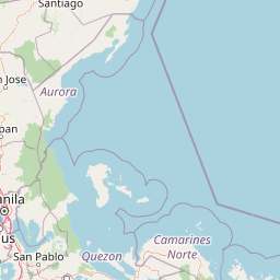
Map view of Alabat Watershed Forest Reserve

Use this park location map to pinpoint Alabat Watershed Forest Reserve in Philippines, understand its exact geographic position, and read its mapped placement within the surrounding landscape more clearly.

Pigeon | © OpenStreetMap contributors

Location context for Alabat Watershed Forest Reserve

Quezon
Park atlas

Compare regional protected areas and connected island conservation networks

Explore Other Parks Near Alabat Watershed Forest Reserve and Surrounding Protected Landscapes

Continue browsing parks near Alabat Watershed Forest Reserve to examine broader regional conservation networks across the surrounding Philippine landscape. Comparing adjacent protected areas reveals interconnected island ecosystems and regional watershed patterns.
Protected landscapeQuezon
About 28 km away#1 closest

Southwest

Quezon Protected Landscape: Mapping the Rainforests and Karst Terrain of Quezon Province

An essential protected landscape in the southern Sierra Madre mountain range.

Quezon Protected Landscape serves as a vital ecological corridor, featuring a rugged mix of karst topography, lowland rainforests, and underground water systems. Explore the geographic layout of this Philippine reserve, which encompasses symbolic summits, cascading waterfalls, and diverse endemic habitats within the southern Sierra Madre foothills.

Area
9.38 km²
Established
2003
IUCN
V
Relief
Mountain
Wildlife reserveQuezon
About 43 km away#2 closest

Southeast

Calauag Watershed Reservation: Geographic Analysis of Protected Rainforest in Quezon Province

Mapping lowland tropical forest terrain and regional watershed boundaries

Located in the rolling hills of Quezon, the Calauag Watershed Reservation serves as a critical protected landscape featuring dense stands of Philippine hardwoods and varied forest microhabitats. This record details the reserve's topography, ranging from moderate slopes to drainage corridors, illustrating its function as both a biodiversity sanctuary and a essential water catchment for the surrounding CALABARZON region.

Area
3.28 km²
Established
1939
Relief
Upland
Climate
Tropical
Nature reserveQuezon
About 47 km away#3 closest

Southeast

Lopez Watershed Forest Reserve: Protected Nature Reserve and Watershed Atlas of Quezon

A foundational rainforest landscape within the Quezon province protected network.

Lopez Watershed Forest Reserve is a significant nature reserve located in the rolling hills of southern Quezon, Philippines. This site preserves a continuous block of tropical lowland and lower montane forest, functioning as an essential watershed catchment area within the broader Luzon landscape. Learn about its institutional importance and its role as an early component of the Philippine protected area management framework.

Area
4.18 km²
Established
1940
Relief
Upland
Water
Minor water
National parkLaguna
About 63 km away#4 closest

West

Pagsanjan Gorge National Park: Philippines National Park & Protected Area Mapping

Explore the geographic context and mapped terrain.

Pagsanjan Gorge National Park represents a key protected natural area within the Laguna region, offering insights into Philippine national park geography. This entry focuses on understanding its mapped boundaries and the surrounding landscape context, providing a foundational element for anyone exploring protected lands through maps and regional atlases. It serves as a gateway to comprehending the park's specific geographic identity and its place within the natural environment of the Philippines.

Area
1.526 km²
Established
1939
IUCN
II
Relief
Upland
Wildlife reserveMarinduque
About 80 km away#5 closest

South

Marinduque Wildlife Sanctuary: Map of the Protected Interior Forest

Exploring the essential wildlife habitats of Marinduque Island

Spanning 8,800 hectares of hilly terrain across five municipalities, the Marinduque Wildlife Sanctuary protects a critical block of forest. This reserve is recognized as a vital sanctuary for endemic Philippine species and forms a significant ecological backbone within the heart of the island landscape.

Area
88.28 km²
Established
2004
Relief
Mountain
Climate
Tropical
Protected areaCamarines Norte
About 83 km away#6 closest

East

Abasig-Matogdon Mananap Natural Biotic Area: Regional Geography and Protected Forest Terrain

A vital ecological reserve in the Bicol Region of Luzon

Located in Camarines Norte, the Abasig-Matogdon Mananap Natural Biotic Area protects critical lowland and montane rainforests surrounding Mount Labo. This area serves as a key component of the regional conservation landscape, defined by its steep volcanic terrain, numerous geothermal springs, and habitat for endemic species within the Philippine archipelago.

Area
54.2 km²
Established
2000
Relief
Mountain
Climate
Tropical
Watercolor painting of a rolling tropical mountain range with palm trees in the foreground, rendered in soft green, pink, and neutral tones.
Nature reserveCalabarzon
About 90 km away#7 closest

West

Mount Makiling Nature Reserve: Volcanic Geography and Forest Landscapes in Calabarzon

A historic forest reserve and prominent volcanic landmark on Luzon

Mount Makiling represents a layered conservation landscape, functioning as both an active site for forest research and a significant volcanic massif within the Calabarzon region. The area features a complex of subsidiary cones, mud springs, and essential watersheds that define its ecological and cultural identity. Gain a deeper understanding of its geographic boundaries and its importance as a pioneering protected area in Philippine conservation history.

Established
1910
Relief
Mountain
Climate
Tropical
Access
Easy access
Wildlife reserveQuezon
About 103 km away#8 closest

Southeast

Mulanay Watershed Forest Reserve: Mapping Protected Lowland Rainforests in Quezon

A watershed conservation site on the Bondoc Peninsula

Spanning 474 hectares in the province of Quezon, the Mulanay Watershed Forest Reserve acts as a protected anchor for local biodiversity and hydrological health. The reserve preserves rolling, forest-covered hills that feed the Cawayan Creek, illustrating the importance of small, strategically managed protected lands within the larger Philippine conservation framework.

Area
4.74 km²
Established
1938
Relief
Upland
Water
Minor water

Common questions about visiting, size, designation, and location context for Alabat Watershed Forest Reserve

Alabat Watershed Forest Reserve FAQs for park facts, access, geography, and protected area context

Find quick answers about Alabat Watershed Forest Reserve, including protected-area facts, park geography, trail and visitor context, and how the park fits into its surrounding country and regional landscape.
MoriAtlas Explorer

Continue Your Protected Areas Search Across the Global Atlas

Deepen your exploration by continuing the structured search for national parks and protected areas worldwide. Utilize the comprehensive filtering capabilities to compare different conservation landscapes and refine your understanding of global park geography. Discover more about the distribution and characteristics of protected natural areas.

Global natural geography