
Mori Atlas logo
Nature reserveAlbersbacher Riedwiesen

A geographic analysis of stream-side valley habitats, floodplain mosaics, and preserved regional biodiversity corridors.

Albersbacher Riedwiesen Nature Reserve: Mapped Protected Landscapes in the Hesse Odenwald

The Albersbacher Riedwiesen nature reserve forms a critical, protected ecological corridor along the Albersbach stream within the Vorderer Odenwald of Hesse. This mapped site encompasses a highly varied mosaic of wet meadows, reedbeds, alder carr, and traditional orchard orchards that trace the natural floodplain. By safeguarding these rare habitats against intensive land use, the reserve serves as an essential geographic anchor for local flora and fauna, illustrating the conservation value of minor mountain stream valleys.

nature reserveNaturschutzgebietwet meadowsreedbedsalder carrorchard meadows
An artistic flat-style illustration showing a winding stream flowing through a grassy valley toward a tall, multi-tiered waterfall cascading down sheer cliffs, framed by forest greenery.

Albersbacher Riedwiesen

Nature reserve

Park overview

Structured park overview, official facts, and landscape profile for Albersbacher Riedwiesen

Albersbacher Riedwiesen park facts, protected area profile, and essential visitor context

Review the core facts for Albersbacher Riedwiesen, including designation, size, terrain, visitor scale, habitats, and operating context in one park-focused overview.

About Albersbacher Riedwiesen

The Albersbacher Riedwiesen is a compact nature reserve that protects one of the smaller tributary valleys of the Weschnitz river system in the Vorderer Odenwald. Although small in area, it is valued for the way it concentrates several ecologically distinct habitat types in immediate proximity: moist meadows flanking the stream, dense reedbeds along its banks, wet alder woodland, traditional orchard meadows on the rising ground, and drier grassland remnants. This juxtaposition creates a habitat mosaic that supports far more biodiversity than the reserve's size would suggest.

The reserve sits within the Geo-Naturpark Bergstraße-Odenwald, a UNESCO Global Geopark that links geological and cultural heritage across the Bergstraße and the Odenwald highlands. The Albersbacher Riedwiesen lies in the southern part of this park landscape, close to the boundary where the wooded Odenwald transitions into the broader Rhine plain. Its character is typical of small valley nature reserves in this region: narrow, linear, and following the natural contours of the stream corridor.

The protected area is administered under the German nature conservation code as a Naturschutzgebiet, the country's strictest category of area protection. This status means that interventions in the reserve are tightly controlled and that the primary management goal is the preservation and development of the habitats and species for which it was designated. Together with neighboring protected sites along the Weschnitz and its tributaries, it forms part of a regional network of small stream-valley reserves that are central to biodiversity conservation in the western Odenwald.

Quick facts and research context for Albersbacher Riedwiesen

The Albersbacher Riedwiesen is a designated nature reserve (Naturschutzgebiet) in the Bergstraße district of Hesse, Germany, on the territory of the municipalities of Rimbach and Mörlenbach. It was placed under protection on 18 March 1996 and covers approximately 12.42 hectares.

The reserve lies in the Vorderer Odenwald, in the natural landscape units known as the Weschnitztal and Juhöhe-Odenwald, and forms part of the larger Geo-Naturpark Bergstraße-Odenwald. Its core feature is the floodplain of the Albersbach stream between the village of Albersbach and the town of Rimbach.

Protection and recognition

Examine official documentation, management scope, and conservation records for this protected landscape.

Albersbacher Riedwiesen Protection Status and Protected Area Designation Facts

Albersbacher Riedwiesen protection status details bring together documented designation history and verified administrative records for the protected area. Review the compiled management scope and international database references associated with the natural reserve.

Protection details

WDPA ID
162057
Park context

Deeper park guide and search-rich context for Albersbacher Riedwiesen

Albersbacher Riedwiesen history, landscape, wildlife, and travel context

Explore Albersbacher Riedwiesen through its history, landscape character, ecosystems, wildlife, conservation priorities, cultural context, and seasonal travel timing in a structured park guide built for atlas discovery and search intent.

Why Albersbacher Riedwiesen stands out

The reserve is known for the compact but ecologically rich floodplain mosaic of the Albersbach, which brings together wet meadows, reedbeds, alder-dominated brook woodland, traditional orchard meadows (Streuobst) and patches of dry grassland within a small catchment. This combination of habitat types along a single short stream is increasingly uncommon in the modern Odenwald landscape, where intensive forestry and agriculture dominate. It also serves as a refuge for bird and insect species typical of structured, semi-open valley habitats, including characteristic breeding and foraging species of Odenwald wet meadows and Brook valleys.

A close-up of a vibrant lime-green puss moth caterpillar resting on a branch, displaying its head-like tail and extended red, whip-like filaments used for defense.
A puss moth caterpillar in a defensive posture, showing its unique red filaments.

Albersbacher Riedwiesen history and protected-area timeline

The Albersbacher Riedwiesen was formally placed under nature protection on 18 March 1996, under the official code 1431024, when the Hessian authorities designated the floodplain of the Albersbach east of the village of Albersbach as a Naturschutzgebiet. The designation recognized that decades of agricultural use along the stream had produced, and still sustained, a habitat mosaic of considerable ecological value.

Before 1996, the meadows and orchard areas were managed in long-standing traditional ways: hay cutting on the wetter grounds, grazing on the drier slopes, and extensive use of the orchard meadows. The protection order was intended to secure these land uses and the habitats they maintain, while also explicitly protecting the Albersbach itself as a habitat for threatened aquatic and bankside species. Today the reserve is managed as part of the broader network of nature reserves in the Bergstraße district and within the framework of the Geo-Naturpark Bergstraße-Odenwald.

Albersbacher Riedwiesen landscape and geographic character

The reserve occupies a narrow, shallow valley along the Albersbach, a stream that rises on the slopes beneath the Zigeunerkopf (about 359.5 m above sea level) and flows from the small village of Albersbach eastward toward Rimbach. Its overall shape is linear, following the natural course of the brook between the wooded hillsides that close in on either side.

The terrain is gently sloping and shaped by the stream's slow meanderings. Flat or only slightly inclined ground dominates near the watercourse, giving way to slightly steeper slopes on the edges of the valley where orchard meadows and dry grassland take over. North of the stream the land belongs to the municipality of Rimbach, while the southern parts are part of Mörlenbach, reflecting how the watercourse itself has long defined administrative as well as ecological boundaries.

The surrounding region is part of the Vorderer Odenwald, with the Weschnitztal and Juhöhe-Odenwald as the two overlapping natural landscape units. Streamside pools, fishponds and wet depressions add further topographic variety beyond the reserve itself, and the wider Weschnitz valley forms the broader geographical setting.
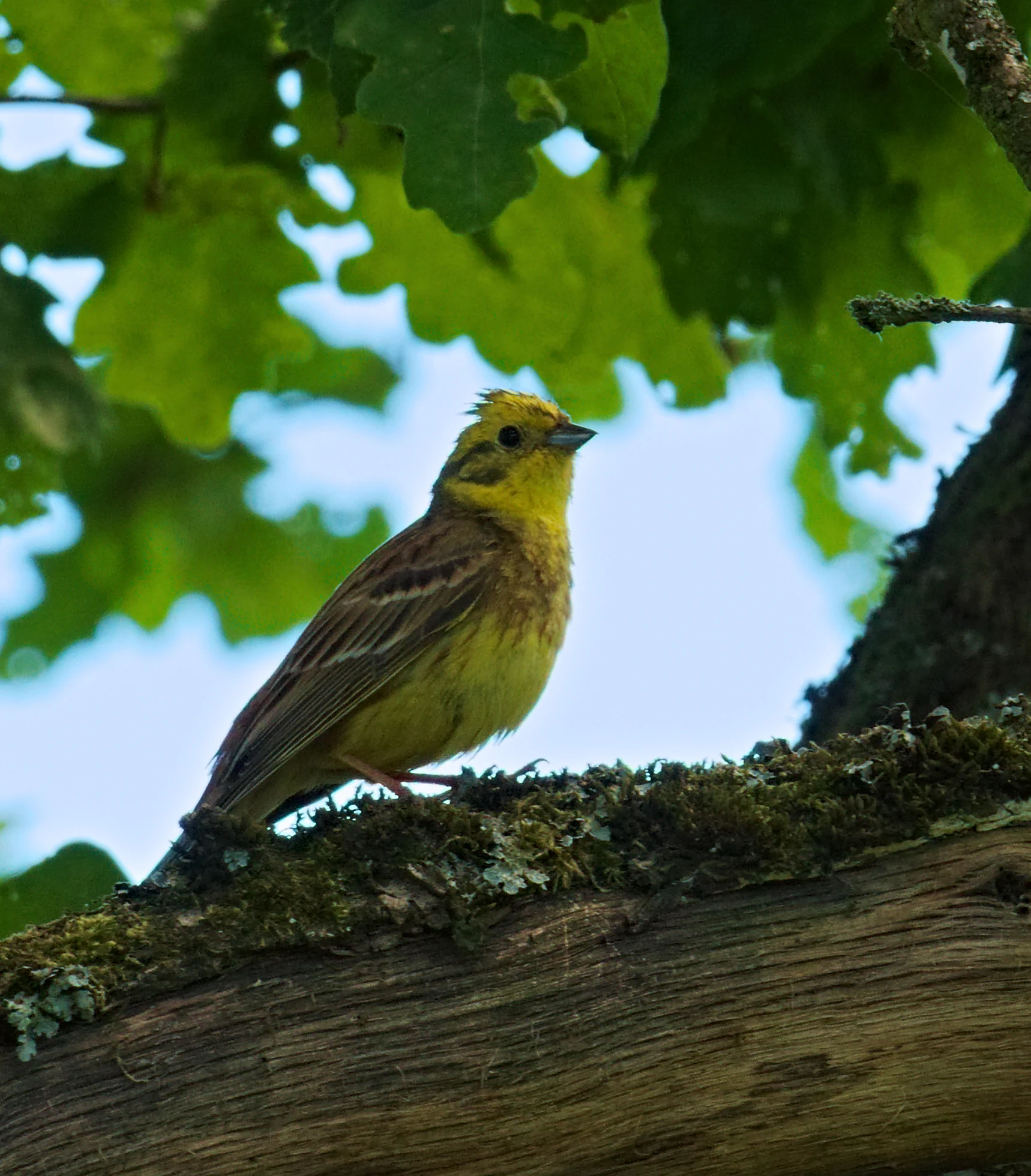
A yellowhammer bird with bright yellow head and breast feathers perched on a textured, moss-covered tree branch against a background of green leaves.
A male yellowhammer perched on a mossy branch in the Albersbacher Riedwiesen nature reserve.

Albersbacher Riedwiesen ecosystems, habitats, and plant life

Ecologically, the Albersbacher Riedwiesen is defined by its wetness gradient and the close interweaving of habitats that result from a single small stream system. Along the banks and in the lowest parts of the valley, reedbeds and sedge-dominated vegetation form a continuous buffer between open water and the surrounding meadows. Further up the gentle slope, the ground passes into species-rich wet meadows whose composition reflects both the underlying groundwater of the floodplain and the long history of low-intensity hay cutting.

Alder carr woodland fringes parts of the stream, adding a shaded brook-forest element to the mosaic. On the better-drained edges of the valley, traditional orchard meadows (Streuobst) carry mature fruit trees scattered across grassland, while small patches of dry grassland (Trockenrasen) occupy the warmest, most exposed positions. This habitat complexity, compressed into a small area, is precisely what gives the reserve its conservation value in a region otherwise dominated by conifer plantations and intensively used farmland.
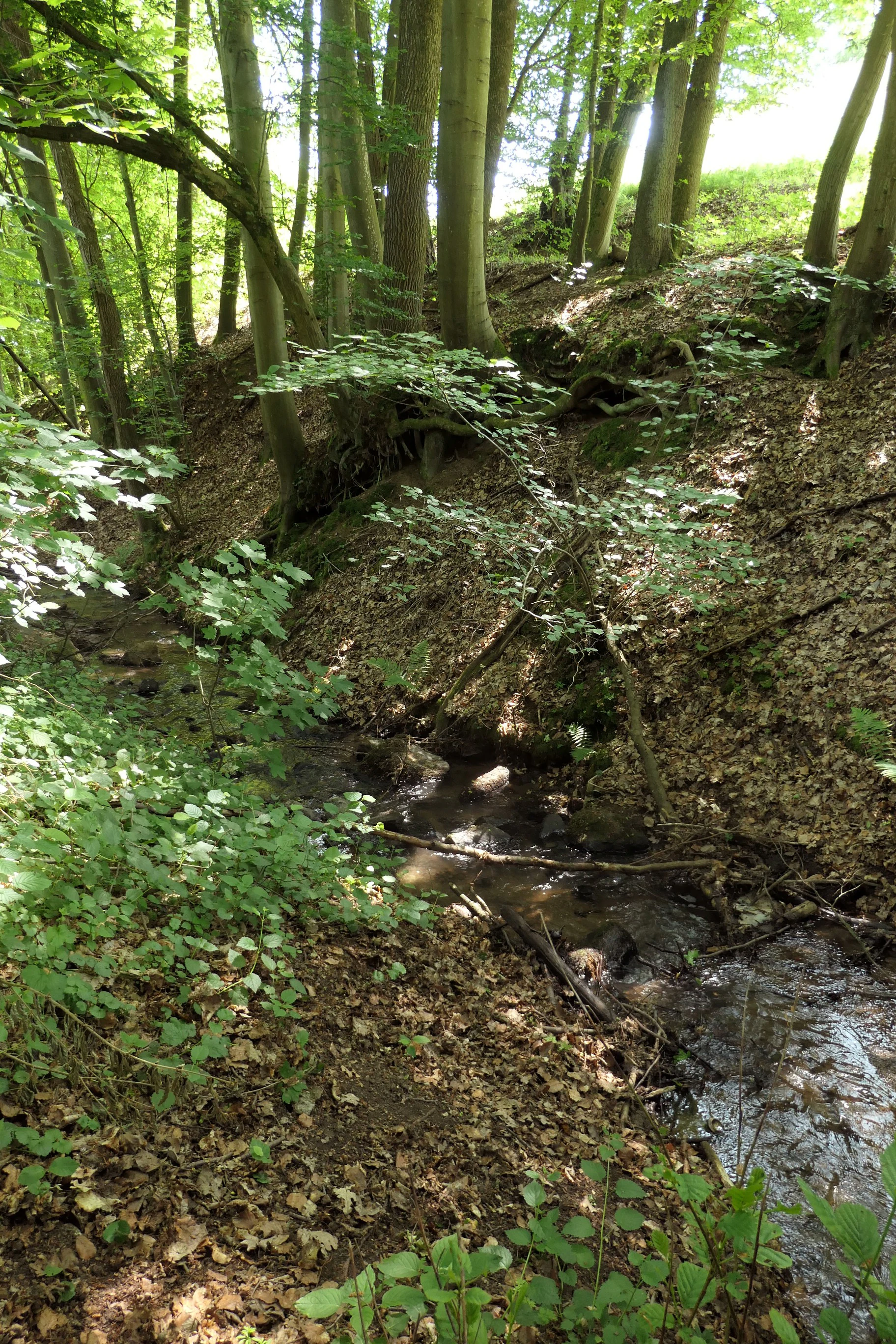
A small, shallow stream flows through a wooded valley, with steep, leaf-covered slopes rising on the right side and dense deciduous forest foliage overhead.
The Albersbach stream flowing through a shaded woodland area in the Albersbacher Riedwiesen nature reserve.

Albersbacher Riedwiesen wildlife and species highlights

The mix of wet meadows, reedbeds, alder woodland and orchard trees makes the Albersbacher Riedwiesen an attractive site for birdlife, amphibians and insects. The yellowhammer, observed and documented at the reserve, is a typical species of the Odenwald's farmland fringe and orchard-meadow habitats, where scattered trees and bushy edges provide song posts and nesting sites. The meadowland butterfly fauna includes species such as the Meadow Brown, reflecting the importance of unimproved grassland for Lepidoptera in this region.

The reedbeds, alder carr and brook channel offer cover and feeding areas for a range of smaller wetland and stream-associated species, while the dry grassland and orchard meadows support characteristic invertebrate communities. The reserve's overall significance lies less in any single charismatic species than in the persistence of an intact habitat mosaic that allows many typical Odenwald valley species to coexist at one small site.
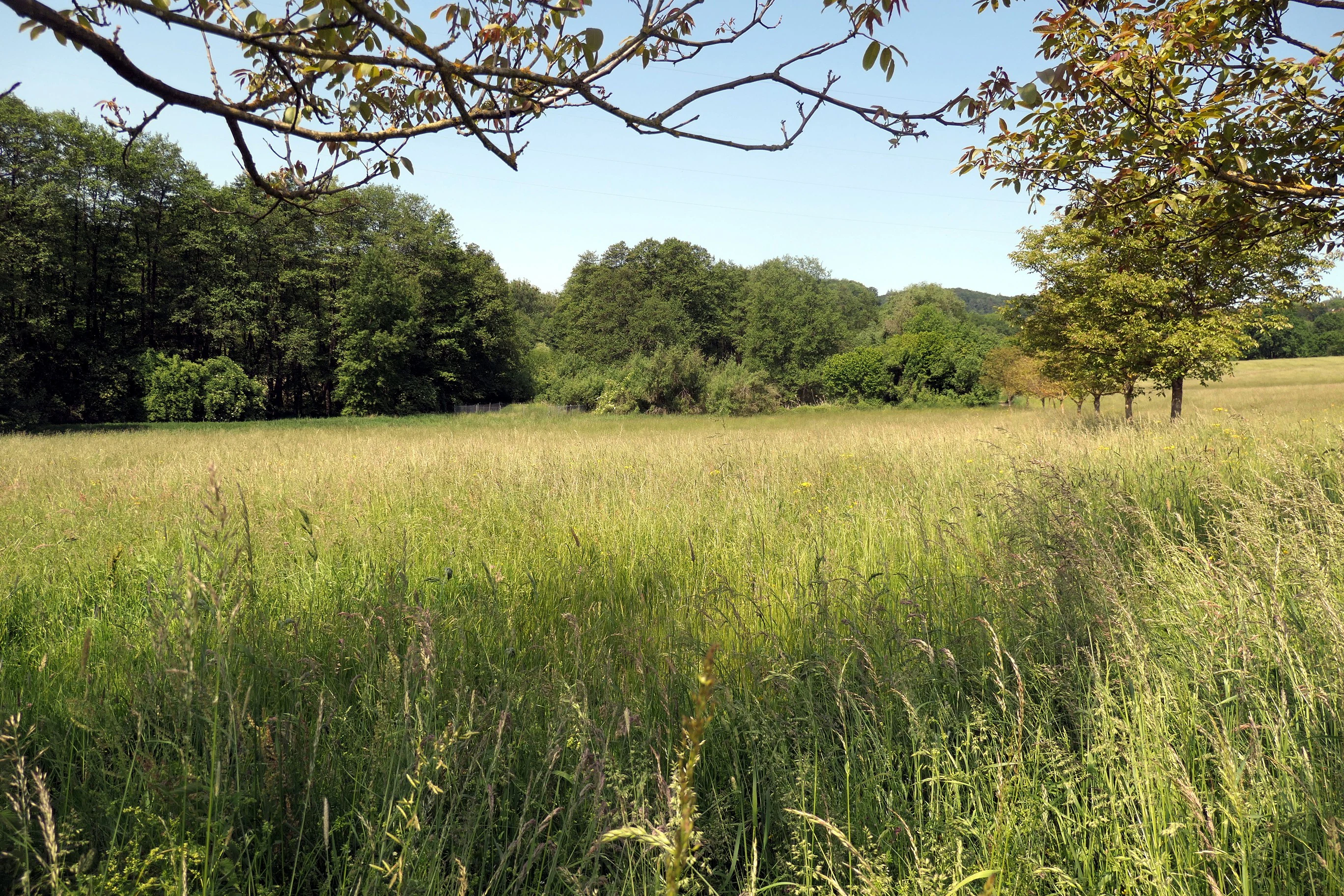
A wide, sunlit meadow filled with tall grasses, framed by tree branches in the foreground and a dense forest line in the background.
A summer view of the meadows and wooded stream valley at Albersbacher Riedwiesen.

Albersbacher Riedwiesen conservation status and protection priorities

The principal conservation purpose of the Albersbacher Riedwiesen is the long-term protection and development of the Albersbach floodplain, including wet meadows, reedbeds, alder carr, orchard meadows and dry grassland, together with the Albersbach itself as a flowing-water habitat. The reserve is intended to maintain the ecological functions of this small valley system and to provide refuge for threatened plant and animal species in an otherwise intensively used part of the Vorderer Odenwald.

Its designation as a Naturschutzgebiet in 1996 placed it within Germany's strongest category of area-based nature protection, restricting potentially damaging interventions and focusing management on habitat preservation. Integrated into the Geo-Naturpark Bergstraße-Odenwald, the reserve is also part of a broader regional strategy that links nature conservation with the cultural and geological heritage of the Bergstraße-Odenwald landscape.

Albersbacher Riedwiesen cultural meaning and human context

The Albersbacher Riedwiesen reflects an older Odenwald cultural landscape in which small valley meadows and scattered orchard trees were central to rural livelihoods. Hay from wet meadows, fruit from the Streuobst orchards, and the careful management of the stream corridor itself shaped both the land and the communities of Albersbach, Rimbach and Mörlenbach that adjoin the reserve.

The continued importance of extensive grassland management and traditional orchard husbandry for the reserve's habitats means that today's conservation work is closely intertwined with preserving elements of regional rural heritage, rather than separating nature from cultural practice.

Top sights and standout views in Albersbacher Riedwiesen

Despite its small size, the Albersbacher Riedwiesen carries an unusually complete cross-section of Odenwald valley habitats in a single short stretch of stream corridor. The meeting of wet meadows, reedbeds, alder carr, orchard meadows and dry grassland within walking distance of one another gives the reserve a layered, highly varied character that is hard to find elsewhere in the modern Vorderer Odenwald.

Equally distinctive is the way the Albersbach itself is treated as a protected feature: a small mountain stream whose course, banks and associated vegetation are safeguarded together, illustrating how even minor tributaries can carry meaningful conservation value when their floodplains remain intact.

Monthly climate preview

Measured annual temperature variation and precipitation patterns for Hesse

Albersbacher Riedwiesen Climate Normals and Long-Term Weather by Month

Long-term representative coordinate records outline the measured annual temperature progression and monthly precipitation rhythm across Albersbacher Riedwiesen. Reviewing the complete twelve-month climatology data provides deeper context for temperature ranges and precipitation normals.
Annual mean10 °C
0 °C20 °C
Jan
Feb
Mar
Apr
May14°
Jun18°
Jul20°
Aug20°
Sep15°
Oct10°
Nov
Dec
Warmest month
July

20.3 °C

Coolest month
January

0.1 °C

Wettest month
July

2.4 mm/day

Driest month
April

1.5 mm/day

Park location guide

Geography guide, regional context, and park location map for Albersbacher Riedwiesen

Albersbacher Riedwiesen park geography, regions, and map view in Germany

Understand where Albersbacher Riedwiesen sits in Germany through a broader geographic reading of the surrounding landscape, nearby location context, and its mapped position within the national park landscape.

How Albersbacher Riedwiesen fits into Germany

Germany is a federal republic in Western and Central Europe with a population of over 83 million across sixteen constituent states. It is Europe's largest economy by nominal GDP and a major global exporter and importer. The capital is Berlin, and the country borders Denmark, Poland, Czech Republic, Austria, Switzerland, France, Luxembourg, Belgium, and the Netherlands.

Wider geography shaping Albersbacher Riedwiesen in Germany

Germany is located in Western and Central Europe, spanning 357,022 km². It borders Denmark to the north, Poland and the Czech Republic to the east, Austria and Switzerland to the south, and France, Luxembourg, Belgium, and the Netherlands to the west. The country has coastlines on the Baltic Sea and North Sea to the north, with the Alps located in the southern region.

Map view of Albersbacher Riedwiesen

Use this park location map to pinpoint Albersbacher Riedwiesen in Germany, understand its exact geographic position, and read its mapped placement within the surrounding landscape more clearly.

Pigeon | © OpenStreetMap contributors

Location context for Albersbacher Riedwiesen

Hesse

Visualizing the floodplain habitats, stream valleys, and protected terrain of the Odenwald

Albersbacher Riedwiesen Photos and Landscape Scenery

Visual documentation captures the rare mosaic of wet meadows, reedbeds, and alder carr defining the Albersbacher Riedwiesen stream corridor. Photographic records reveal the gentle brookside terrain and protected landscape character unique to the southern Odenwald region.

A close-up of a vibrant lime-green puss moth caterpillar resting on a branch, displaying its head-like tail and extended red, whip-like filaments used for defense.

Side profile of a Meadow Brown butterfly with tan and orange wings featuring a black eyespot, perched on a small yellow buttercup flower against a blurred green meadow background.

A yellowhammer bird with bright yellow head and breast feathers perched on a textured, moss-covered tree branch against a background of green leaves.

A small, shallow stream flows through a wooded valley, with steep, leaf-covered slopes rising on the right side and dense deciduous forest foliage overhead.

A wide, sunlit meadow filled with tall grasses, framed by tree branches in the foreground and a dense forest line in the background.

A view of a grassy wetland area with tall reeds and surrounding trees under a clear sky in Albersbacher Riedwiesen.

Park atlas

Compare adjacent stream valleys, forest reserves, and protected landscapes across the Odenwald.

Exploring Parks Near Albersbacher Riedwiesen and Surrounding Regional Protected Areas

Continue browsing parks near Albersbacher Riedwiesen to evaluate similar floodplain habitats and stream corridors. Expanding the comparison across the surrounding regional terrain reveals broader conservation patterns in the Odenwald.
A wide watercolor illustration showing a river curving through a grassy valley with trees and hills in the background.
Nature reserveHessen
About 2.8 km away#1 closest

South

In der Erbach bei Mörlenbach Nature Reserve: Protected Odenwald Stream Valley

Regional geography and habitat mapping in southern Hessen

The In der Erbach bei Mörlenbach nature reserve preserves a well-defined side-valley ecosystem within the broader Odenwald landscape. Its protected boundaries encompass a moisture-rich corridor featuring wet meadows, reedbeds, and forest edges that exemplify the traditional cultural geography of the Weschnitz river basin in southern Germany.

Area
0.197 km²
Established
1997
IUCN
IV
Relief
Upland
A horizontal watercolor illustration of a soft green landscape with meadows, scattered trees, and distant rolling hills under a pale pink sky.
Nature reserveHessen
About 7.1 km away#2 closest

North

Schannenbacher Moor Nature Reserve: Geographic Overview and Protected Area Boundaries

Wetland and forest mosaic in the southern Hessian Odenwald

Schannenbacher Moor represents a significant protected area within Hessen, characterized by its combination of raised bog remnants, reedbeds, and near-natural floodplain woodlands. Framed by the Krehberg slopes and the Meerbach stream system, the reserve offers a rare example of low mountain bog ecology and biodiversity conservation. This mapped landscape provides essential data on the distribution of mire plant communities and bryophyte habitats in the region.

Area
0.162 km²
Established
1975
IUCN
IV
Nature reserveHesse
About 8.1 km away#3 closest

South

In der Striet bei Vöckelsbach Nature Reserve: Regional Geography and Mapped Protected Landscapes

A compact forest and wetland mosaic in the Odenwald of southern Hesse

The nature reserve In der Striet bei Vöckelsbach is an essential protected area covering four and a half hectares of valley floor. It provides a dense habitat gradient from reeded spring zones through alder forests to mixed deciduous slopes. This record details the park landscape, stream systems, and its integration into the larger Geo Naturpark Bergstraße Odenwald and Natura 2000 protected areas.

Area
0.048 km²
Established
1988
A watercolor painting of a pastoral landscape with soft green meadows, scattered trees, and distant purplish hills under a white sky.
Nature reserveHessen
About 8.5 km away#4 closest

Northwest

Magerrasen von Gronau mit angrenzenden Flächen Protected Landscape and Regional Geography

A network of calcareous meadows in the Odenwald foothills

Located in the Bergstraße district of Hessen, this protected area spans three distinct sub-areas characterized by nutrient-poor calcareous soils. These warm, sun-exposed meadows serve as an essential refugium for orchid diversity and specialized butterfly populations, standing as a representative example of successfully managed dry grassland ecosystems within the broader Geo-Naturpark Bergstraße-Odenwald.

Area
1.6 km²
Established
2004
A horizontal watercolor illustration of a soft, rolling landscape with a central winding path or stream, green meadows, distant hills, and foreground trees and flowers.
Nature reserveHesse
About 9.4 km away#5 closest

East

Gras-Ellenbacher Wiesen Nature Reserve: Protected Valley Basin Geography and Map Overview

Wet meadows and seepage habitats within the Odenwald hills

Situated in a gentle hollow near the Dachsberg and Kirchberg ridges, Gras-Ellenbacher Wiesen represents an essential Hessian nature reserve. This overview highlights the interplay between the Ulfenbach stream, drainage infrastructure, and traditional meadow management that defines this distinct sandstone upland protected landscape.

Area
0.241 km²
Established
1981
IUCN
IV
Relief
Upland
A wide watercolor painting showing rolling green hills and trees with pale pink and yellow hues across a valley landscape.
Nature reserveHessen
About 11 km away#6 closest

East

Rotes Wasser von Olfen Nature Reserve: Protected Wetland and Odenwald Geography

A unique bog and iron-rich stream landscape in Hessen, Germany.

Rotes Wasser von Olfen preserves a rare, small-scale mosaic of transitional bog and wet meadow vegetation within the Odenwald range. This protected site features reddish, iron-rich seepage waters and provides essential habitat for specialized flora and dragonfly populations amidst a surrounding forested mountain landscape.

Area
0.121 km²
Established
1980
IUCN
IV
Relief
Upland
Watercolor painting showing a stylized, panoramic landscape of rolling hills and forest, depicted in soft green and earth tones against a white background.
Nature reserveHessen
About 11 km away#7 closest

North

Felsberg bei Reichenbach Nature Reserve: Geography and Granite Boulder Field Analysis

Protected forest and geological monument in the Odenwald range

Felsberg bei Reichenbach protects 168 hectares of Odenwald mountain slope in Southern Hessen. The site is centered on the Felsenmeer, a dramatic sea of granite boulders created by frost weathering, framed by mixed deciduous woodland. This area functions as an important Natura 2000 habitat, preserving both specialized rock ecosystems and montane forest, providing a clear geographic link between the Lautertal valley and the high slopes of the Felsberg summit.

Area
1.677 km²
Established
1972
IUCN
IV
Relief
Mountain
Watercolor painting of soft, rolling green hills and meadows in a minimalist style, set against a light background.
Nature reserveHessen
About 12 km away#8 closest

Southeast

Dürr-Ellenbachtal von Wald-Michelbach: Odenwald Nature Reserve and Protected Valley Geography

A historic meadow valley in Hessen, Germany

The Dürr-Ellenbachtal von Wald-Michelbach nature reserve protects an elongated, narrow valley framed by forested ridges in the central Odenwald. This area is defined by its meandering brook, diverse alder stands, and species-rich meadows that sustain significant local biodiversity. As a key Natura 2000 site, it serves as an essential example of protected meadow landscapes and rural mountain terrain within the Bergstraße district.

Area
0.542 km²
Established
1990
IUCN
IV
Relief
Mountain

Common questions about visiting, size, designation, and location context for Albersbacher Riedwiesen

Albersbacher Riedwiesen FAQs for park facts, access, geography, and protected area context

Find quick answers about Albersbacher Riedwiesen, including protected-area facts, park geography, trail and visitor context, and how the park fits into its surrounding country and regional landscape.
MoriAtlas Explorer

Continue Your Protected Areas Search Across the Global Atlas

Deepen your exploration by continuing the structured search for national parks and protected areas worldwide. Utilize the comprehensive filtering capabilities to compare different conservation landscapes and refine your understanding of global park geography. Discover more about the distribution and characteristics of protected natural areas.

Global natural geography