
Mori Atlas logo
Nature reserveAlte See – Ruhmberg

Exploring the ecological transition of former military grounds into a diverse mosaic of wetlands, meadows, and open hill country.

Alte See – Ruhmberg Nature Reserve: A Detailed Geographic Atlas of a Saxon Protected Landscape

(Naturschutzgebiet Alte See – Ruhmberg)

The Alte See – Ruhmberg nature reserve in Saxony, Germany, represents a significant conservation area spanning 266 hectares across the Parthenstein and Grimma landscape. This site serves as a vital case study in ecological recovery, where a centuries old millpond, alder carr wetlands, and the open grassy slopes of the Ruhmberg provide habitats for hundreds of red listed vascular plant species, breeding birds, and invertebrates. By tracing the topography from the pond edge to the hill summit, visitors can analyze how past military land use has shaped the current varied terrain, creating a unique intersection of history and natural biodiversity within the Leipzig region.

wetlandsnature reserveSaxonyopen grasslandalder carrformer military site
A flat style digital illustration of a green valley with birch trees, distant mountains, a small waterfall, and a few houses under a pink sky.

Alte See – Ruhmberg

Nature reserve

Park overview

Structured park overview, official facts, and landscape profile for Alte See, Ruhmberg

Alte See, Ruhmberg park facts, protected area profile, and essential visitor context

Review the core facts for Alte See, Ruhmberg, including designation, size, terrain, visitor scale, habitats, and operating context in one park-focused overview.

About Alte See, Ruhmberg

Alte See – Ruhmberg is a nature reserve in the German state of Saxony that protects a layered mosaic of wetland, meadow, and open hill habitats on the edge of the Landkreis Leipzig, between the villages of Grethen and the town of Grimma. The name combines two defining landscape elements of the site: the Alte See, a centuries-old pond created by damming the Parthe river, and the Ruhmberg, a low but ecologically significant hill directly to its east.

The protected area reflects a long history of changing land use. The pond itself dates back to at least the fifteenth century, when the Parthe was dammed at Grethen to operate a mill, and the resulting inundation zone gradually developed into an alder swamp, now recognized as a classic moisture-rich woodland. Around 1961, a first small reserve of roughly 22.6 hectares was established around the pond and its swamp, making it one of the older local conservation sites in the region.

The eastern portion of today's reserve is a reminder of more recent history. Until the end of the nineteenth century, the land around the Ruhmberg was ordinary farmland, but in the early 1900s it was taken over by the German military, and later by the Soviet army stationed in Grimma, as a training and exercise ground. This military use kept the area open for nearly a century, and regular grazing by sheep maintained a heath-like character across large parts of it. After the Soviet troops withdrew in 1993, the combination of long-term disturbance and the absence of intensive cultivation allowed a wide range of species to colonize the site.

In 2015, the Saxon authorities formally designated the combined area as a single nature reserve, joining the old pond protection with the eastern hill landscape. Today, the reserve is recognized for an exceptional concentration of biodiversity for its size, with multiple biotope complexes carefully managed through traditional practices such as annual haymaking, sheep grazing, and the protection of relict military earthworks that now serve as habitat features.

Quick facts and research context for Alte See, Ruhmberg

Alte See – Ruhmberg is a Saxon nature reserve (Naturschutzgebiet) classified under IUCN Category IV, meaning it is managed primarily for the conservation of specific habitats and species rather than for full ecosystem protection. It lies in Landkreis Leipzig and spans parts of the municipality of Parthenstein and the town of Grimma.

The reserve covers about 2.66 square kilometers, with elevations ranging from 147 meters at the pond to 169 meters on the Ruhmberg hill. It sits within the natural regions of the Naunhofer Moränenplatten to the west and the Nordsächsisches Platten- und Hügelland to the east, and is crossed by the Parthe river. Designation was finalized in 2015, building on an older 1961 protection around the pond itself and incorporating the former military training area east of the pond after Soviet forces withdrew in 1993.

Protection and recognition

Examine documented protected area records and official designation data.

Alte See – Ruhmberg Protection Status and International Recognition Records

Alte See – Ruhmberg brings together verified protection status metrics and official international recognition records for conservation analysis. Global database records track the protected area designation details alongside baseline geographical parameters.

Protection details

WDPA ID
162096
Park context

Deeper park guide and search-rich context for Alte See, Ruhmberg

Alte See, Ruhmberg history, landscape, wildlife, and travel context

Explore Alte See, Ruhmberg through its history, landscape character, ecosystems, wildlife, conservation priorities, cultural context, and seasonal travel timing in a structured park guide built for atlas discovery and search intent.

Why Alte See, Ruhmberg stands out

The reserve is best known for showing how a former military training ground can transform into high-quality habitat for rare plants, breeding birds, and invertebrates when left to natural processes. The Alte See pond and its surrounding alder carr represent one of the older wetland conservation sites in the Leipzig region, while the Ruhmberg hill offers an unusually well-developed mosaic of dry grassland, scrub, and small woodland patches that echoes the earlier open heath-like character of the landscape. Its biodiversity density is also a defining trait: in a relatively small area, more than 450 vascular plant species, over 90 breeding bird species, 9 bat species, and a long list of invertebrates, including mollusks and hymenopterans, have been documented, with many of the species being red-listed in Saxony.
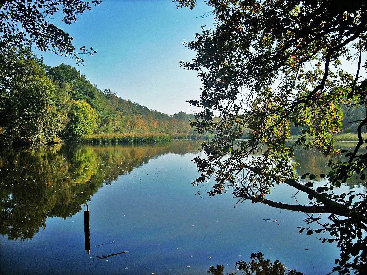
A calm, reflective pond surrounded by lush forest and a gentle hill in the background, framed by overhanging tree branches in the foreground.
The tranquil waters of the Alte See pond in the nature reserve near Grethen.

Alte See, Ruhmberg history and protected-area timeline

The history of Alte See – Ruhmberg stretches across roughly six centuries and layers very different kinds of human use on one another. The earliest chapter is associated with the Alte See itself: in the fifteenth century, the Parthe river at Grethen was dammed to create a millpond, and in the shallow, periodically flooded margins of that pond, a wet woodland of alder developed. As early as 1938, the Saxon local historian Max Kästner pointed out the ecological significance of this wetland.

The first formal protection came in 1961, when a small area of about 22.6 hectares around the pond was declared a nature reserve under the name Alte See. The eastern half of today's site, by contrast, was not protected at all in that period. Until the late nineteenth century it was used as meadow and arable land, then around the turn of the century it was requisitioned for military purposes following the construction of the Königin-Carola-Kaserne in Grimma for a Hussar regiment. The hill area became a training and exercise ground, and that role continued for nearly a hundred years, including the Soviet military era after the Second World War.

The modern history of the reserve begins in 1993, when Soviet troops left Grimma and a long stretch of the country's eastern landscape became accessible to civilian use and conservation. Because the area had been kept open by grazing and had not been intensively farmed, it offered unusually good conditions for ecological recovery. This combination of historic pond protection, military legacy, and a long period of relative ecological calm set the stage for the unified designation of 2015, when the old pond reserve and the former training area were merged under a single protective framework.

Alte See, Ruhmberg landscape and geographic character

The landscape of Alte See – Ruhmberg is shaped by gentle relief and a strong contrast between water and dry ground. Elevations range from about 147 meters along the Alte See to roughly 169 meters on the summit of the Ruhmberg, a modest but meaningful difference that gives the reserve clear topographic variety. The western part of the area belongs to the Naunhofer Moränenplatten of the Leipzig lowland, while the eastern portion lies in the Nordsächsisches Platten- und Hügelland, so the site straddles two related but distinct natural regions.

The northern edge of the reserve is defined by the Saxon state road S 38, the eastern edge by the federal road B 107a. Within these boundaries, three broad landscape units recur. First is the pond and its alder carr, a low-lying wetland where the Parthe river has long shaped the ground. Second is the open and semi-open country around the Ruhmberg, where small patches of woodland, scattered shrubs, and individual bushes alternate with grassland on sandy, well-drained substrates. Third is the so-called Königswiese between the hill and the pond, a wider floodplain meadow through which the Parthe continues toward Grethen.

Relict features of the area's military past remain visible across the Ruhmberg landscape, including old embankments, ditches, and small structures that interrupt the otherwise smooth sweep of the grassland. These subtle earthworks, together with the natural topography, give the reserve a varied texture rather than a uniform meadow plain, and they help create microhabitats for warmth-loving plants and insects.

Alte See, Ruhmberg ecosystems, habitats, and plant life

Alte See – Ruhmberg represents an unusually rich ecological mosaic for its size in Saxony. Three interconnected biotope complexes form the ecological backbone of the reserve: the still waters of the Alte See and the surrounding alder carr, the open and semi-open habitats on and around the Ruhmberg, and the wet meadows of the Königswiese between them. The combination of pond, marsh, grassland, scrub, and small woodland edges supports very different kinds of species in close proximity.

More than 450 species of ferns and flowering plants have been recorded in the reserve, a remarkable diversity for an area of only a few hundred hectares. Many of these species appear on the Saxon Red List, reflecting the conservation value of the site. Open-ground species benefit from the dry, often sandy conditions of the Ruhmberg area, while moisture-loving plants concentrate along the pond margins and in the meadow zone.

Habitat management is an active part of the reserve's ecological character. The Königswiese is mown twice a year for hay and then grazed by sheep, a traditional practice that maintains the open meadow structure and the rich herb layer. On the Ruhmberg slopes, sheep grazing continues to play a role in keeping woody plants from closing in over the grassland. The result is a dynamic balance between open, semi-open, and shaded conditions rather than a single uniform habitat type.

Alte See, Ruhmberg wildlife and species highlights

Wildlife is one of the most striking aspects of the reserve. Surveys have documented more than 90 breeding bird species across the site, taking advantage of the juxtaposition of wetland, meadow, scrub, and dry grassland within a small area. The pond and alder carr provide habitat for water-associated species, while the open slopes of the Ruhmberg support ground-nesting and scrub-edge species that have become scarce in more intensively used landscapes.

Nine bat species have been recorded in the reserve, including species that exploit the woodland margins, old structures, and water features for roosting and feeding. The invertebrate fauna is also notably diverse. Among insects, 154 hymenopteran species have been catalogued, and in the Alte See area alone, 52 species of mollusks have been identified, nine of which are on the Saxon Red List. These numbers underline the value of the reserve as a refuge for taxa that are otherwise declining in central Germany.

The diversity of fauna mirrors the diversity of the habitats: the wetland side of the reserve supports moisture-dependent invertebrates and amphibians, while the drier, historically grazed slopes favor warmth-loving insects and ground-active species. The old military earthworks on the Ruhmberg add small-scale variations in slope and exposure that increase habitat variety even further.

Alte See, Ruhmberg conservation status and protection priorities

Conservation is the central purpose of Alte See – Ruhmberg. The reserve is classified as a German Naturschutzgebiet with IUCN Category IV status, which reflects a management emphasis on specific habitats and species rather than on a wholly untouched landscape. This classification fits the site's character: it combines natural processes with traditional human management practices such as haymaking and sheep grazing, both of which are considered essential to maintaining biodiversity.

The site's conservation value rests on three pillars. The first is the historic protection of the Alte See wetland, in place since 1961, which has preserved one of the older examples of alder carr in the Landkreis Leipzig area. The second is the long-term open-land character of the Ruhmberg, maintained for nearly a century by military use and sheep grazing, which prevented the afforestation that would otherwise have overtaken much of the area. The third is the unusually high concentration of red-listed plants and animals, from vascular plants and breeding birds to bats, mollusks, and hymenopteran insects.

The 2015 designation united these values under one framework, integrating the older pond protection with the broader landscape around the Ruhmberg. By recognizing the area's land-use legacy rather than treating it as a disruption, the management approach aims to preserve the mosaic of habitats that evolved under that specific history.

Alte See, Ruhmberg cultural meaning and human context

The cultural context of Alte See – Ruhmberg is closely tied to the layered human use of its landscape. The Alte See itself is a man-made feature, created when the Parthe was dammed at Grethen in the fifteenth century to power mills, and its name, Alte See, literally "old pond," reflects that age. Early attention to the site's ecological significance came from the Saxon local historian Max Kästner, who highlighted the value of the alder carr as early as 1938.

The eastern part of the reserve carries a strong military cultural legacy. The construction of the Königin-Carola-Kaserne in Grimma for a Hussar regiment and the subsequent conversion of the Ruhmberg area into a training ground tied local identity to the military presence for generations. The departure of Soviet forces in 1993 marked the end of that era and opened the way both for civilian access and for a new cultural reading of the landscape as a site of ecological rather than military significance.

Traditional land management continues to shape the area in a softer way: haymaking on the Königswiese and sheep grazing on the slopes are living practices, not museum pieces, and they remain part of the working identity of the villages of Grethen, Parthenstein, and Grimma that border the reserve.

Top sights and standout views in Alte See, Ruhmberg

Alte See – Ruhmberg stands out for the way it bundles ecological, historical, and cultural significance into a relatively small Saxon landscape. The combination of a centuries-old millpond, a well-developed alder wetland, a dry open hill with relict military features, and a maintained floodplain meadow gives the reserve a layered sense of place that few comparable sites can offer within Landkreis Leipzig.

Its biodiversity statistics are unusually high for the size of the protected area, with hundreds of plant species and rich communities of breeding birds, bats, mollusks, and insects, many of them red-listed. The blend of protected wetland, managed grassland, and recovering open hill also makes it a clear demonstration of how former disturbed land can become a biodiversity hotspot when given the chance.

Best time to visit Alte See, Ruhmberg

Alte See – Ruhmberg can be visited at any time of year, but the character of the landscape shifts noticeably with the seasons. Late spring and early summer are often the richest period for flowering plants on the dry slopes of the Ruhmberg and for observing breeding birds and insects across the reserve. Summer highlights the contrast between the green meadow zones of the Königswiese and the warmer, drier tones of the hill country.

Autumn brings the russet colors of the alder carr around the Alte See and is a good season for observing migratory activity and fruiting woodland species. In winter, the open structure of the Ruhmberg area becomes particularly easy to appreciate, and the gentle topography makes the reserve accessible for short, low-key walks as long as paths are not icy. Visitors interested in wetland birds and amphibians may find early spring a particularly rewarding period, when the pond margins come back to life.

Monthly climate preview

Measured temperature ranges and precipitation patterns across representative coordinates

Alte See – Ruhmberg Climate Normals and Long-Term Weather by Month

Historical climatology records for Alte See – Ruhmberg track monthly average temperatures from sub-freezing winter minimums to warm summer maximums alongside consistent daily precipitation. Examining the complete twelve-month profile provides deeper insight into long-term meteorological normals across the protected landscape.
Annual mean9 °C
-1 °C19 °C
Jan-1°
Feb
Mar
Apr
May13°
Jun17°
Jul19°
Aug19°
Sep14°
Oct
Nov
Dec
Warmest month
July

19.1 °C

Coolest month
January

-0.9 °C

Wettest month
July

2.7 mm/day

Driest month
April

1.3 mm/day

Park location guide

Geography guide, regional context, and park location map for Alte See, Ruhmberg

Alte See, Ruhmberg park geography, regions, and map view in Germany

Understand where Alte See, Ruhmberg sits in Germany through a broader geographic reading of the surrounding landscape, nearby location context, and its mapped position within the national park landscape.

How Alte See, Ruhmberg fits into Germany

Germany is a federal republic in Western and Central Europe with a population of over 83 million across sixteen constituent states. It is Europe's largest economy by nominal GDP and a major global exporter and importer. The capital is Berlin, and the country borders Denmark, Poland, Czech Republic, Austria, Switzerland, France, Luxembourg, Belgium, and the Netherlands.

Wider geography shaping Alte See, Ruhmberg in Germany

Germany is located in Western and Central Europe, spanning 357,022 km². It borders Denmark to the north, Poland and the Czech Republic to the east, Austria and Switzerland to the south, and France, Luxembourg, Belgium, and the Netherlands to the west. The country has coastlines on the Baltic Sea and North Sea to the north, with the Alps located in the southern region.

Map view of Alte See, Ruhmberg

Use this park location map to pinpoint Alte See, Ruhmberg in Germany, understand its exact geographic position, and read its mapped placement within the surrounding landscape more clearly.

Pigeon | © OpenStreetMap contributors

Location context for Alte See, Ruhmberg

Saxony

Visualizing the habitats, terrain, and wetland ecosystems of Saxony

Alte See – Ruhmberg Landscape Photos and Protected Area Scenery

Visual documentation of Alte See – Ruhmberg reveals the complex topography of the Leipzig lowland, capturing wetland alder carr and dry grassland mosaics across the protected reserve. Photographic evidence of the terrain provides deeper insight into the ecological recovery and habitat structure shaped by centuries of land use.

A calm, reflective pond surrounded by lush forest and a gentle hill in the background, framed by overhanging tree branches in the foreground.

An expanse of dry, yellowish-green grassland dotted with small bushes and scattered trees under a cloudy sky.

Park atlas

Compare adjacent protected landscapes and regional nature reserves

Explore Other Parks Near Alte See – Ruhmberg in Saxony

Discover protected areas and nature reserves surrounding Alte See – Ruhmberg to compare regional wetland habitats and lowland hill terrain. Examining these adjacent conservation lands provides deeper context on the ecological diversity found across the Leipzig region.
A horizontal watercolor painting showing a tranquil lake with soft green hills and sparse vegetation along the shoreline under a pale, warm sky.
Nature reserveSachsen
About 15 km away#1 closest

Southwest

Bockwitz Nature Reserve: Mapping the Industrial Reclamation Landscapes of Sachsen, Germany

A Protected Mosaic of Rewetted Lakes and Mining Follow-on Terrain

Spanning 545 hectares, the Bockwitz nature reserve offers a unique look at the transformation of former lignite opencast pits into a thriving wetland habitat. The protected area is characterized by its significant residual water bodies, including Bockwitzer See and the Südkippe pit, which showcase the evolution of Sachsen landscape geography following industrial decline. This site serves as a vital example of habitat management within an anthropogenic environment.

Area
5.454 km²
Established
2003
IUCN
IV
Water
Major water bodies
A horizontal watercolor illustration depicting a wetland landscape with grassy banks, a winding stream, and reeds.
Nature reserveSachsen
About 22 km away#2 closest

Southwest

Eschefelder Teiche: Protected Wetland Landscapes and Pond Geography in Sachsen

Historic water basins and regional wetland habitats

The Eschefelder Teiche nature reserve occupies a distinctive position in the Saxon landscape, tracing a historic chain of artificial ponds from Frohburg to Eschefeld. This protected area offers insight into managed wetland ecosystems, featuring the expansive Großteich and preserved heritage structures like the Teichhaus complex, which remain central to local conservation and bird populations.

Area
5.62 km²
Relief
Lowland
Climate
Temperate
Access
Easy access
Nature reserveSachsen
About 24 km away#3 closest

East

Scheergrund Nature Reserve: Geographic Atlas and Protected Landscape Overview

Mapping the geology and woodland history of the Leisnig region

Scheergrund functions as a vital nature reserve and geological reference site within the Saxon landscape. This area provides insight into Holocene tufa systems, ancient dam structures, and the complex interplay between spring-fed stream morphology and human development in the Freiberger Mulde tributary valley.

Area
0.578 km²
Established
1961
IUCN
IV
A horizontal watercolor painting depicting a soft-focus forest in the foreground and rolling hills in the background.
Nature reserveThuringia
About 27 km away#4 closest

South

Leinawald Nature Reserve: Mapping the Protected Forests and Wetland Habitats of Eastern Thuringia

A comprehensive look at the landscape geography, pond networks, and conservation status of this German woodland.

Leinawald represents a unique confluence of historical forestry, wartime heritage, and ecological recovery within the Altenburger Land region. The area is defined by its loess-mantled ridges and periodic wetland valleys, containing a complex grid of ponds, brooks, and secondary habitats formed in former quartz quarries. Understanding the environmental layers of this site reveals the intersection of natural vegetation potential and 20th century landscape transformation.

Area
18.437 km²
Established
1961
IUCN
IV
Relief
Upland
A soft watercolor painting depicting a serene floodplain forest with trees, grasses, and a winding stream, rendered in light green and muted tones.
Nature reserveLeipzig
About 31 km away#5 closest

Northwest

Burgaue Nature Reserve: Alluvial Forest and Hydrological Geography in Leipzig, Germany

Protected floodplain woodland and restored wetland corridors.

Burgaue is a distinctive nature reserve forming the northwestern anchor of the Elster Luppe floodplain. This urban-adjacent protected area preserves a complex topography of historic river channels, wet depressions, and hardwood forest. Through recent hydrological restoration, the landscape maintains its status as a vital riparian habitat and a significant element of the regional Saxon environment.

Area
2.7 km²
Established
1367
Relief
Lowland
Climate
Temperate
Nature reserveThuringia
About 32 km away#6 closest

Southwest

Phönix Nord Nature Reserve: Mapped Protected Area in the Altenburger Land of Thuringia

A restored post-mining mosaic of heath, scrub, and woodland

Phönix Nord preserves a unique post-mining landscape shaped by historic lignite extraction. This nature reserve in Thuringia features a mosaic of rewilded slopes and reclaimed mineral soils, managed as a vital habitat for native species. Through its distinct topography and conservation efforts, it stands as a key example of industrial renaturation in central Germany.

Area
1.672 km²
Established
2008
IUCN
IV
Relief
Lowland
Nature reserveSaxony
About 32 km away#7 closest

South

Um die Rochsburg Nature Reserve: Geography and Protected River Valley Landscapes in Saxony

A vital riverine conservation zone along the Zwickauer Mulde.

Spanning over 250 hectares, Um die Rochsburg protects the steep, wooded slopes of the Zwickauer Mulde and Brausebach valleys. This nature reserve highlights the regional importance of river-influenced terrain and managed habitat corridors within the Mittelsachsen landscape of Saxony.

Area
2.596 km²
Established
1961
IUCN
IV
Nature reserveSaxony
About 33 km away#8 closest

North

Vereinigte Mulde Eilenburg, Bad Düben: Protected Floodplain Landscapes of Saxony

Riparian river geography and protected meadow corridors

Spanning over 1,400 hectares along the Mulde river, this nature reserve in Nordsachsen preserves an essential lowland river system. The protected area encompasses diverse riparian forests, oxbow features, and flood meadows that define the natural character of the unified Mulde valley between the towns of Eilenburg and Bad Düben.

Area
14.53 km²
Established
2001
IUCN
IV
Relief
Lowland

Common questions about visiting, size, designation, and location context for Alte See, Ruhmberg

Alte See, Ruhmberg FAQs for park facts, access, geography, and protected area context

Find quick answers about Alte See, Ruhmberg, including protected-area facts, park geography, trail and visitor context, and how the park fits into its surrounding country and regional landscape.
MoriAtlas Explorer

Continue Your Protected Areas Search Across the Global Atlas

Deepen your exploration by continuing the structured search for national parks and protected areas worldwide. Utilize the comprehensive filtering capabilities to compare different conservation landscapes and refine your understanding of global park geography. Discover more about the distribution and characteristics of protected natural areas.

Global natural geography