
Mori Atlas logo
Nature reserveNaturschutzgebiet Alter Hagen bei Willingen

Mapping the headwater valleys and relict forest ecosystems of this protected German nature reserve

Naturschutzgebiet Alter Hagen bei Willingen: Protected Landscapes and Wetland Geography

Discover the complex ecological landscape of Naturschutzgebiet Alter Hagen bei Willingen, a protected area in the upland region of Hessen. This nature reserve preserves a distinct mosaic of spring-fed headwater streams, transition mires, and montane meadows that harbor rare ice-age relict flora. Gain insight into the regional geography and conservation importance of this unique floodplain valley system through our structured park data.

nature reserveHesseWillingenwetland habitatheadwater valleyupland forest
A flat, vector-style illustration of a canyon valley featuring steep pinkish mountain walls, a central winding river, a waterfall, and dense coniferous forests in the foreground and midground.

Naturschutzgebiet Alter Hagen bei Willingen

Nature reserve

Park overview

Structured park overview, official facts, and landscape profile for Alter Hagen bei Willingen

Alter Hagen bei Willingen park facts, protected area profile, and essential visitor context

Review the core facts for Alter Hagen bei Willingen, including designation, size, terrain, visitor scale, habitats, and operating context in one park-focused overview.

About Alter Hagen bei Willingen

The Alter Hagen bei Willingen is a compact yet ecologically dense nature reserve in the Rothaargebirge foothills, protecting an otherwise fragmented landscape of springs, headwater streams, mires, and damp forests on the edge of the Hesse-North Rhine-Westphalia state line. Although small compared with major national parks, it concentrates a remarkable range of habitat types within a short valley system, making it a strong example of German habitat-based protected-area management (IUCN Category IV).

The reserve was legally designated in 1989 because of its botanical and zoological significance, with particular emphasis on rare plant communities and species tied to traditional, lightly managed grassland and forest. Today it sits within the broader Naturpark Diemelsee and contributes key habitat to the EU Habitats Directive site NSG-Komplex bei Willingen, connecting it functionally to neighboring reserves such as Grebensteine bei Willingen to the north and Jägers Weinberg to the east.

Geographically, the area combines the source springs and upper course of the Itter river with narrower side valleys, surrounded by forested slopes. The southern and western edges follow the state border between Hesse and North Rhine-Westphalia, where the watershed separates this catchment from rivers flowing west. This borderland position reinforces the reserve's ecological value by linking it directly to the cross-border Neuer Hagen protected area.

Alongside natural values, the reserve preserves a notable cultural landscape element. Since 1987, the grassland areas have been grazed by Heidschnucken sheep (a traditional breed of the Lüneburg Heath) and goats maintained by the Bigger Josefsheim of the Josefs-Gesellschaft, helping to keep the meadows open and sustain the open-ground flora that defines much of the area's character.

Quick facts and research context for Alter Hagen bei Willingen

The Alter Hagen bei Willingen is a 143.55-hectare nature reserve in the Waldeck-Frankenberg district of northern Hesse, directly south of the Upland resort town of Willingen. Established as a protected area in 1989 under German nature conservation law, it carries the official national identifier 1635032 and is recorded in the World Database on Protected Areas under WDPA ID 162112.

The reserve lies within the Naturpark Diemelsee and constitutes a sub-area of the EU Habitats Directive site NSG-Komplex bei Willingen. Its southern and western boundaries run along the state border between Hesse and North Rhine-Westphalia, which here also marks a watershed divide. To the west, the contiguous North Rhine-Westphalia nature reserve Neuer Hagen extends across the border.

Protection and recognition

Explore documented terrestrial protection metrics and official designation records.

Naturschutzgebiet Alter Hagen bei Willingen Protection Status and Recognition

Terrestrial protection status for Naturschutzgebiet Alter Hagen bei Willingen compiles verified administrative metrics and conservation records into a single reference view. Systematic database tracking provides clear insight into official boundaries, management scope, and international recognition sources without speculation.

Protection details

Protection scope
Terrestrial
Transboundary protection
No
WDPA ID
162112
Park context

Deeper park guide and search-rich context for Alter Hagen bei Willingen

Alter Hagen bei Willingen history, landscape, wildlife, and travel context

Explore Alter Hagen bei Willingen through its history, landscape character, ecosystems, wildlife, conservation priorities, cultural context, and seasonal travel timing in a structured park guide built for atlas discovery and search intent.

Why Alter Hagen bei Willingen stands out

Alter Hagen bei Willingen is best known for its concentration of rare wetland and mire habitats in an otherwise forested upland setting. The reserve's headwater streams, sedge-dominated seepage areas, and transition mires are home to relict plant species from the last ice age, especially the northern purple reedgrass (Calamagrostis phragmitoides), which is considered a glacial relict. Beyond its botanical interest, the nature reserve is valued for its fern- and clubmoss-rich relict beech forest fragments, its wet birch woodlands, and its open montane meadows along the hillsides. The mixture of clear, near-natural streams, bog margins, and old-growth woodland creates a habitat mosaic that supports breeding boreal owl and Eurasian woodcock, as well as one of Hesse's richest known butterfly communities.
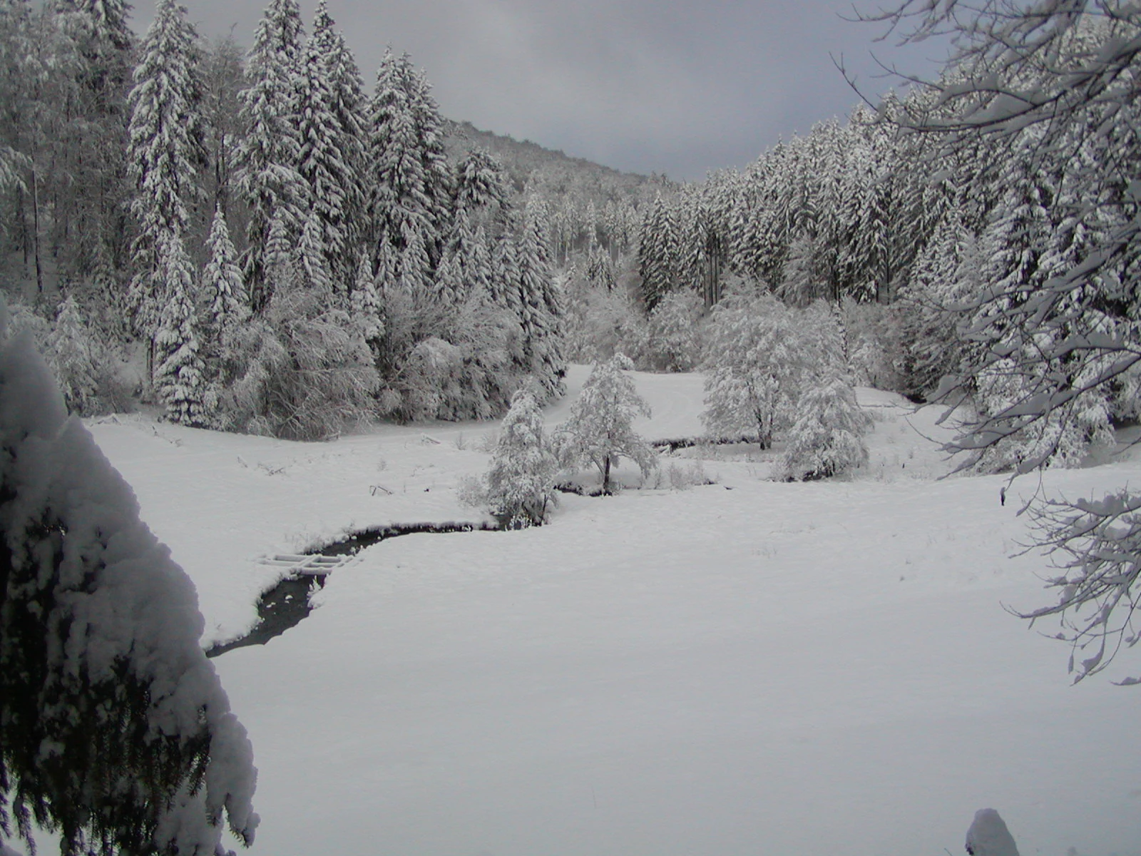
A snowy, winter landscape featuring a small, winding stream cutting through a snow covered meadow, surrounded by a dense forest of snow-laden coniferous trees.
A snow covered valley within the Alter Hagen bei Willingen nature reserve.

Alter Hagen bei Willingen history and protected-area timeline

The reserve represents a relatively modern legal designation built on older land-use patterns. The open meadows of the valley have a long tradition of pastoral use, and these traditional grasslands are the foundation for many of the plant species the area was later protected to conserve.

A formal conservation step came in 1987, when the Bigger Josefsheim of the Josefs-Gesellschaft began grazing the reserve's grassland areas with Heidschnucken sheep and goats. This grazing management continues to shape the present-day habitat pattern, keeping herb-rich meadows and orchid-rich wet grasslands from being lost to scrub or forest encroachment.

In 1989, the area was officially designated as a Naturschutzgebiet under Hesse's nature conservation law, citing its significance for botany and wildlife and the rarity, special character, and beauty of the landscape. It was later incorporated as a component of the larger EU Habitats Directive site NSG-Komplex bei Willingen, giving it recognition under European conservation frameworks as well.

Alter Hagen bei Willingen landscape and geographic character

The landscape of Alter Hagen bei Willingen is defined by the shallow, spring-fed headwater valley of the Itter and its small tributary side valleys, which together cut through a gently rolling upland plateau near the Rothaargebirge. The valley floor is broad enough in places to accommodate wet meadows and mires, while the surrounding slopes rise into forested ridges that form the visual horizon of the reserve.

Much of the valley is water-shaped. Clear, near-natural brooks, some of them spring channels, run through the reserve, fed by groundwater emerging along the watershed with neighboring drainage systems. The streams maintain strong flow and relatively natural character, supporting gravel beds and mossy banks that shade into swampy fringes.

Along the valley sides, the terrain transitions from open meadows and rough pasture into increasingly closed woodland. Beech forest dominates much of the slope, with wet birch woodland appearing in transitional zones and patches of spruce plantation in some areas. The mix of open mire, tall herb meadows, forest edge, and closed woodland gives the reserve a layered, transitional feel typical of upland Central German stream valleys.

Alter Hagen bei Willingen ecosystems, habitats, and plant life

Ecologically, Alter Hagen bei Willingen is defined by its wetland and forest-edge habitats. The valley floor supports Braunseggen (brown sedge) seepage communities along the Itter, grading into fens with cottongrass, marsh cinquefoil, and grey sedge. These bog and fen patches include Sphagnum moss communities and are among the most botanically distinctive elements of the reserve.

The woodland habitats are equally varied. Relict beech stands rich in ferns and clubmosses represent fragments of an older, more diverse montane beech forest, while wet birch woodland occupies transition zones. Some parts of the reserve carry spruce plantings that contrast with the natural broadleaf vegetation around them.

Open habitats layer into the wetland and forest mosaic. Sumpfdotterblumen (marsh marigold) communities and Molinia (purple moor grass) swards occupy damp meadows, with Glatthafer and Goldhafer hay meadows on drier ground and abandoned patches colonized by bramble and bistort. Together these habitats produce a finely graduated ecological gradient from saturated bog through wet grassland to dry meadow and forest.

Alter Hagen bei Willingen wildlife and species highlights

The wildlife profile of Alter Hagen bei Willingen centers on species tied to old woodland and clean, flowing water. The reserve has documented breeding Raufußkauz (Tengmalm's owl) and Waldschnepfe (Eurasian woodcock), both of which favor mature, structurally complex forest, and the amphibian assemblage includes common frog, common toad, and fire salamander, with the forest lizard as the only recorded reptile.

Streams here are particularly important. The native fish fauna includes Groppe (bullhead) and brown trout, while the mollusk community includes Flussmützenschnecke (river nerite) and the spring-dwelling Dunkers Quellschnecke. The clean, swift-flowing nature of the brooks also supports the Blauflügel-Prachtlibelle (a calopteryx damselfly).

The reserve's butterfly fauna is unusually rich for its size, with 71 recorded species including 27 butterflies. Notable taxa include Dukatenfalter, Mädesüß-Perlmuttfalter, and the Großer Schillerfalter, together with a strong population of the Wegerichbär moth. The reserve also holds the only Hessian record of the goldrod-feeding tortricid moth Pelochrista decolorana.

Alter Hagen bei Willingen conservation status and protection priorities

Alter Hagen bei Willingen holds conservation value at three nested levels: as a nationally designated nature reserve under Hesse law, as part of a broader Naturpark, and as a sub-area of the EU Habitats Directive site NSG-Komplex bei Willingen. Its overlap with the Neuer Hagen reserve across the state border adds a transnational conservation dimension to the protected area network.

The reserve's principal conservation importance lies in its combination of mire, montane meadow, and mature forest habitats within a single catchment. These support glacial-relict plant species, rare orchid taxa, and a diverse invertebrate fauna that includes species of very limited regional distribution. Protection of the area's hydrology is central: the springs, seepage zones, and saturated valley soils sustain both the plant communities and the clean-water fauna that depend on them.

Active management is integral to this conservation strategy. Sustained grazing with Heidschnucken sheep and goats preserves the open grassland character of the valley, maintaining habitat for orchids, butterflies, and meadow flora that would otherwise decline under succession. Alongside the legal protection of 1989, this ongoing management preserves a working cultural landscape whose ecological value depends on continued traditional use.

Alter Hagen bei Willingen cultural meaning and human context

The reserve reflects a long-standing cultural relationship with the upland landscape around Willingen. Its open meadows and pastures have been shaped over generations by grazing and hay-cutting, practices that produced the herb-rich grassland flora and orchid-rich wet swards that the area was later protected to conserve.

The current grazing regime, run since 1987 by the Bigger Josefsheim of the Josefs-Gesellschaft using Heidschnucken sheep and goats, is itself part of this heritage. Heidschnucken are strongly associated with traditional conservation grazing in Germany, and their use here links the reserve to broader German efforts to maintain open heath, bog margin, and meadow habitats through low-intensity livestock management.

The reserve also lies in a borderland cultural setting. Its southern and western edges run along the Hesse-North Rhine-Westphalia state line, where villages, dialects, and land-use traditions cross the watershed. The neighboring Skywalk Willingen observation platform brings visitors into close visual proximity with the reserve, positioning it within an upland tourism region that combines skiing, hiking, and ecological tourism.

Top sights and standout views in Alter Hagen bei Willingen

Standout qualities of the reserve include its glacial-relict flora, especially the northern Calamagrostis phragmitoides, and the unusual combination of seepage mires, sedge fens, and relict fern-rich beech forest within a compact valley system.

Equally distinctive is the reserve's invertebrate record, including 71 documented moth and butterfly species and one of Hesse's only known populations of Pelochrista decolorana. The clean, spring-fed Itter headwaters support bullhead, brown trout, and rare spring-dwelling mollusks, reinforcing the reserve's importance for both aquatic and terrestrial biodiversity.

Best time to visit Alter Hagen bei Willingen

Late spring through early summer is generally the most rewarding time to experience the reserve, when montane meadows carry rich herb and orchid displays and forest birds are most active. Late spring is also favorable for viewing fritillary and other spring-hatching butterflies in the meadows and forest clearings.

Summer offers the best chance to encounter flowering meadows in full development, while still supporting active butterfly populations along the forest margins and bog edges. Because much of the value of the reserve lies in its plant communities and breeding birds rather than dramatic vistas, visits tend to be quiet, low-key outings at any time the weather is mild and the meadows are accessible.

Monthly climate preview

Long-term representative temperature ranges and monthly precipitation patterns

Naturschutzgebiet Alter Hagen bei Willingen Climate Normals and Weather by Month

Historical records for Naturschutzgebiet Alter Hagen bei Willingen show measured average temperatures ranging from subzero minimums to warm summer maximums alongside steady daily precipitation. Detailed monthly climate normals provide complete statistical context for analyzing long-term meteorological trends across the coordinate point.
Annual mean9 °C
0 °C18 °C
Jan
Feb
Mar
Apr
May12°
Jun15°
Jul18°
Aug18°
Sep14°
Oct
Nov
Dec
Warmest month
July

18 °C

Coolest month
January

-0.2 °C

Wettest month
July

2.6 mm/day

Driest month
April

1.7 mm/day

Park location guide

Geography guide, regional context, and park location map for Alter Hagen bei Willingen

Alter Hagen bei Willingen park geography, regions, and map view in Germany

Understand where Alter Hagen bei Willingen sits in Germany through a broader geographic reading of the surrounding landscape, nearby location context, and its mapped position within the national park landscape.

How Alter Hagen bei Willingen fits into Germany

Germany is a federal republic in Western and Central Europe with a population of over 83 million across sixteen constituent states. It is Europe's largest economy by nominal GDP and a major global exporter and importer. The capital is Berlin, and the country borders Denmark, Poland, Czech Republic, Austria, Switzerland, France, Luxembourg, Belgium, and the Netherlands.

Wider geography shaping Alter Hagen bei Willingen in Germany

Germany is located in Western and Central Europe, spanning 357,022 km². It borders Denmark to the north, Poland and the Czech Republic to the east, Austria and Switzerland to the south, and France, Luxembourg, Belgium, and the Netherlands to the west. The country has coastlines on the Baltic Sea and North Sea to the north, with the Alps located in the southern region.

Map view of Alter Hagen bei Willingen

Use this park location map to pinpoint Alter Hagen bei Willingen in Germany, understand its exact geographic position, and read its mapped placement within the surrounding landscape more clearly.

Pigeon | © OpenStreetMap contributors

Location context for Alter Hagen bei Willingen

Hessen

Visual reference for upland mire habitats, stream valleys, and relict beech forests

Naturschutzgebiet Alter Hagen bei Willingen Photos and Landscape Scenery

Visual documentation captures the varied terrain, headwater streams, and wetland habitats of Naturschutzgebiet Alter Hagen bei Willingen. Photographic records reveal the ecological character of raised bogs, montane meadows, and ancient woodland stands across the protected landscape.

A snowy, winter landscape featuring a small, winding stream cutting through a snow covered meadow, surrounded by a dense forest of snow-laden coniferous trees.

Park atlas

Compare regional protected landscapes, upland forests, and neighboring wetland reserves

Explore Other Parks Near Naturschutzgebiet Alter Hagen bei Willingen

Browsing other parks near Naturschutzgebiet Alter Hagen bei Willingen reveals a connected network of upland valleys and protected landscapes across northern Hesse. Comparing these neighboring natural reserves provides broader geographic context for Central German wetland and forest habitats.
Nature reserveWaldeck-Frankenberg
About 0.5 km away#1 closest

East

Naturschutzgebiet Jägers Weinberg: Geographic Profile of a Protected Upland Wetland

A mapped nature reserve in the Waldeck-Frankenberg district of northern Hesse

Naturschutzgebiet Jägers Weinberg is a protected wetland landscape in northern Hesse, Germany. This area preserves a rare combination of raised bog and birch swamp forest, functioning as a vital botanical refuge in the Waldeck-Frankenberg district. Its mapped boundaries highlight a specialized ecological site that offers clear insights into the micro-topography and natural history of the local Upland terrain.

Area
0.254 km²
Established
1979
IUCN
IV
Relief
Upland
A watercolor-style digital illustration of a gentle, rolling green landscape with a winding path and distant hills on a white background.
Nature reserveWaldeck-Frankenberg
About 1.4 km away#2 closest

North

Naturschutzgebiet Grebensteine bei Willingen: Protected Forest and Rock Outcrop Atlas

Ecological mapping of the Itter valley gorge forest in Waldeck-Frankenberg

This nature reserve protects a rare, near-primary gorge forest (Schluchtwald) in northern Hesse. Its steep slopes are characterized by isolated rock outcrops, boulder-rich substrates, and springs that foster high botanical diversity. The site serves as a critical example of upland forest conservation within the larger protected landscape of the Rothaargebirge foothills and the Diemelsee Nature Park.

Area
0.157 km²
Established
1985
IUCN
IV
Relief
Mountain
Nature reserveNordrhein-Westfalen
About 2.4 km away#3 closest

West

Hoppecke-Quellbäche Nature Reserve: Protected Headwater Landscapes in Nordrhein-Westfalen

Highland spring and mountain brook habitats within the Rothaargebirge

Hoppecke-Quellbäche safeguards essential headwater habitats across the mid-slopes of the Clemensberg and the high ground leading to the Langenberg. This nature reserve, organized into three distinct parcels, maps the hydrological connections that feed the upper Hoppecke stream within the broader protected-area network of the northern Sauerland region.

Area
0.169 km²
Established
2008
IUCN
IV
Relief
Mountain
Nature reserveNorth Rhine-Westphalia
About 3.6 km away#4 closest

South

Naturschutzgebiet Oberes Dittelsbachtal - Klokenbruch: Regional Protected Area Map

Sauerland brook valley and meadow landscape

This nature reserve protects 14 hectares of the upper Dittelsbach stream and surrounding damp grasslands. The landscape is defined by its compact valley form, spring-fed mires, and traditional grazing patches, serving as an important link for bird protection in the Medebacher Bucht region of North Rhine-Westphalia.

Area
0.139 km²
Established
2003
Scope
Terrestrial
Water
Major water bodies
A soft watercolor painting depicting a landscape of rolling green hills, gentle slopes, and distant mountains against a plain background.
Nature reserveHessen
About 3.9 km away#5 closest

East

Naturschutzgebiet Kahle Pön bei Usseln: Protected Highland Heath and Upland Landscapes

A rare botanical nature reserve within the Hessian Upland landscape

Naturschutzgebiet Kahle Pön bei Usseln protects an open heath plateau above the Usseln valley, providing essential habitat for heath-breeding birds and rare butterflies. This nature reserve serves as an vital component of the transboundary highland heath network, demonstrating unique conservation efforts through sheep grazing and sod removal on former beech woodland soils in Waldeck-Frankenberg.

Area
0.35 km²
Established
1987
IUCN
IV
Nature reserveHochsauerlandkreis
About 4 km away#6 closest

Southeast

Naturschutzgebiet Almecke: Geographic Atlas and Protected Landscape Overview

A preserved hedgerow mosaic in the Hochsauerlandkreis region.

Naturschutzgebiet Almecke is a significant nature reserve characterized by its formal inclusion in the European bird protection area network. The site offers a concentrated look at traditional cultural landscapes, specifically the interaction between steep valley topography, contour-following hedgerows, and dry upland pastures. This protected area serves as an essential case study in localized conservation geography and habitat structure within the wider Sauerland region.

Area
0.058 km²
Established
2003
Relief
Upland
Scope
Terrestrial
Nature reserveHesse
About 5.4 km away#7 closest

Northeast

Naturschutzgebiet Osterkopf bei Usseln: Protected Highland Heath and Upland Landscape

Hesse nature reserve with Atlantic-Boreal botanical features

Located in the Upland highlands of northern Hesse, this protected area features rare summit heath and species-rich mountain meadows. The reserve represents a functional link in the regional network of highland ecosystems, preserving specialized habitats characterized by mat-grass swards and an unusual northern vegetation profile.

Area
0.357 km²
Established
1982
IUCN
IV
Relief
Mountain
Nature reserveHochsauerlandkreis
About 5.9 km away#8 closest

East

Naturschutzgebiet Osterntal: Protected Valley Mosaic and Regional Geography

Explore nature reserve boundaries and ecological terrain in Hochsauerlandkreis.

Naturschutzgebiet Osterntal protects a distinct valley mosaic in the eastern Sauerland, featuring rare wet grasslands and nutrient-poor meadows. This nature reserve provides essential habitat connectivity within the broader European Bird Protection Area, showcasing the region's managed pastoral landscape and varied topography.

Area
0.064 km²
Established
2003
Relief
Upland
Climate
Temperate

Common questions about visiting, size, designation, and location context for Alter Hagen bei Willingen

Alter Hagen bei Willingen FAQs for park facts, access, geography, and protected area context

Find quick answers about Alter Hagen bei Willingen, including protected-area facts, park geography, trail and visitor context, and how the park fits into its surrounding country and regional landscape.
MoriAtlas Explorer

Continue Your Protected Areas Search Across the Global Atlas

Deepen your exploration by continuing the structured search for national parks and protected areas worldwide. Utilize the comprehensive filtering capabilities to compare different conservation landscapes and refine your understanding of global park geography. Discover more about the distribution and characteristics of protected natural areas.

Global natural geography