
Mori Atlas logo
Nature reserveAm Stadtwaldsee (Uni-Wildnis)

Examining the mapped boundaries, secondary habitat ponds, and woodland terrain of a unique urban refuge.

Am Stadtwaldsee (Uni-Wildnis) Nature Reserve: A Detailed Atlas of Bremen's Protected Landscapes

(Naturschutzgebiet Am Stadtwaldsee (Uni-Wildnis))

Am Stadtwaldsee (Uni-Wildnis) stands as a distinct nature reserve in the Horn-Lehe district of Bremen. This protected area represents an unusual secondary habitat that emerged from sand extraction sites used for university and motorway construction. Our atlas data maps the intricate mosaic of ponds, wetland margins, and forest patches that now define this compact environmental refuge within the city. Researchers and geography enthusiasts can examine the reserve's unique land formation and its continued ecological significance as a managed natural site.

nature reservesecondary habitatponds and wetlandsurban biodiversity refugewoodlandsmall protected area
A minimalist, flat-style vector illustration showing a winding path in the foreground leading toward a valley with tall cliffs, waterfalls, and pine trees under a pale sky with a sun.

Am Stadtwaldsee (Uni-Wildnis)

Nature reserve

Park overview

Structured park overview, official facts, and landscape profile for Am Stadtwaldsee (Uni-Wildnis)

Am Stadtwaldsee (Uni-Wildnis) park facts, protected area profile, and essential visitor context

Review the core facts for Am Stadtwaldsee (Uni-Wildnis), including designation, size, terrain, visitor scale, habitats, and operating context in one park-focused overview.

About Am Stadtwaldsee (Uni-Wildnis)

Nestled in Bremen's Horn-Lehe neighborhood, Am Stadtwaldsee (Uni-Wildnis) is one of the many small but ecologically valuable Naturschutzgebiete within the city-state of Bremen. Although it spans only around 11.4 hectares, the reserve plays an outsized role as a local biodiversity refuge, surrounded by motorways, recreational lakes, forests, and camping grounds.

The reserve's defining story is one of unintentional ecological recovery. The ponds that now characterize the area were originally excavated when sand was being extracted for major infrastructure projects, including the construction of the University of Bremen campus and the expansion of the A27 motorway. The ground that was disturbed and then left to its own devices became part of the larger Stadtwaldsee site, a former spoil and storage area that, over years of abandonment, gradually transformed into a functioning habitat of open water and woodland.

In the early 1980s, a portion of this developing landscape was deliberately enclosed with a ring ditch, shaping the boundaries of what would later become today's protected area. The formal step of designating it as a nature reserve came on 16 March 1991. Since then, the area has functioned under Bremen's nature reserve framework, registered as number 11, and managed to maintain its mosaic of ponds and forest.

Ownership of the site remains with the University of Bremen, linking the reserve's identity directly to the institution whose construction inadvertently created it. Day-to-day care and stewardship are handled by the volunteer association Freunde der Uniwildnis, which funds its activities through membership fees and donations. Their work is particularly visible in regular cleanup operations, since the reserve sits close to the intensively used Stadtwaldsee and is prone to litter drift.

Within Bremen's broader network of nature reserves, including wetlands, river plains, marshlands, and bird protection areas, Am Stadtwaldsee stands out as one of the few sites whose character is defined by industrial-era secondary succession. It demonstrates how even a small reserve can have high educational and ecological value when it preserves a complete cycle of disturbance, abandonment, and ecological recovery.

Quick facts and research context for Am Stadtwaldsee (Uni-Wildnis)

Am Stadtwaldsee (Uni-Wildnis) is a nature reserve of about 11.4 hectares in the Free Hanseatic City of Bremen, Germany, classified under IUCN Category IV as a Habitat/Species Management Area. It is registered in Bremen's nature reserve register as number 11 and has been under formal protection since 16 March 1991.

The reserve sits in the Horn-Lehe district, south of the Bundesautobahn 27, bordered by the Bremen Stadtwald forest, two camping areas, and the larger Stadtwaldsee lake. Ownership lies with the University of Bremen, while the responsible authority is Bremen's Senator for Environment, Climate and Science. The site is typical secondary habitat, its ponds and woodland having arisen from former sand-extraction pits used during construction projects.

Protection and recognition

Examine documented protection records and official conservation designations

Am Stadtwaldsee (Uni-Wildnis) Protection Status and International Recognition

Am Stadtwaldsee (Uni-Wildnis) protection status details provide verified data regarding protected area designation and registry records. Documented international recognition facts outline official conservation frameworks associated with the protected landscape.

Protection details

WDPA ID
162185
Park context

Deeper park guide and search-rich context for Am Stadtwaldsee (Uni-Wildnis)

Am Stadtwaldsee (Uni-Wildnis) history, landscape, wildlife, and travel context

Explore Am Stadtwaldsee (Uni-Wildnis) through its history, landscape character, ecosystems, wildlife, conservation priorities, cultural context, and seasonal travel timing in a structured park guide built for atlas discovery and search intent.

Why Am Stadtwaldsee (Uni-Wildnis) stands out

Am Stadtwaldsee is best known for being a textbook example of a secondary habitat within a major German city. The reserve's ponds and surrounding woodland developed from former sand-extraction pits that were dug to supply fill material for the University of Bremen and the construction of the Bundesautobahn 27. Its compact mosaic of ponds, wetland edges, and forest patches within an urban context makes it a small but ecologically meaningful refuge. It is also recognized for its active citizen stewardship. The volunteer group Freunde der Uniwildnis carries out ongoing care and maintenance, including regular litter removal given the reserve's proximity to the heavily used Stadtwaldsee recreation area.
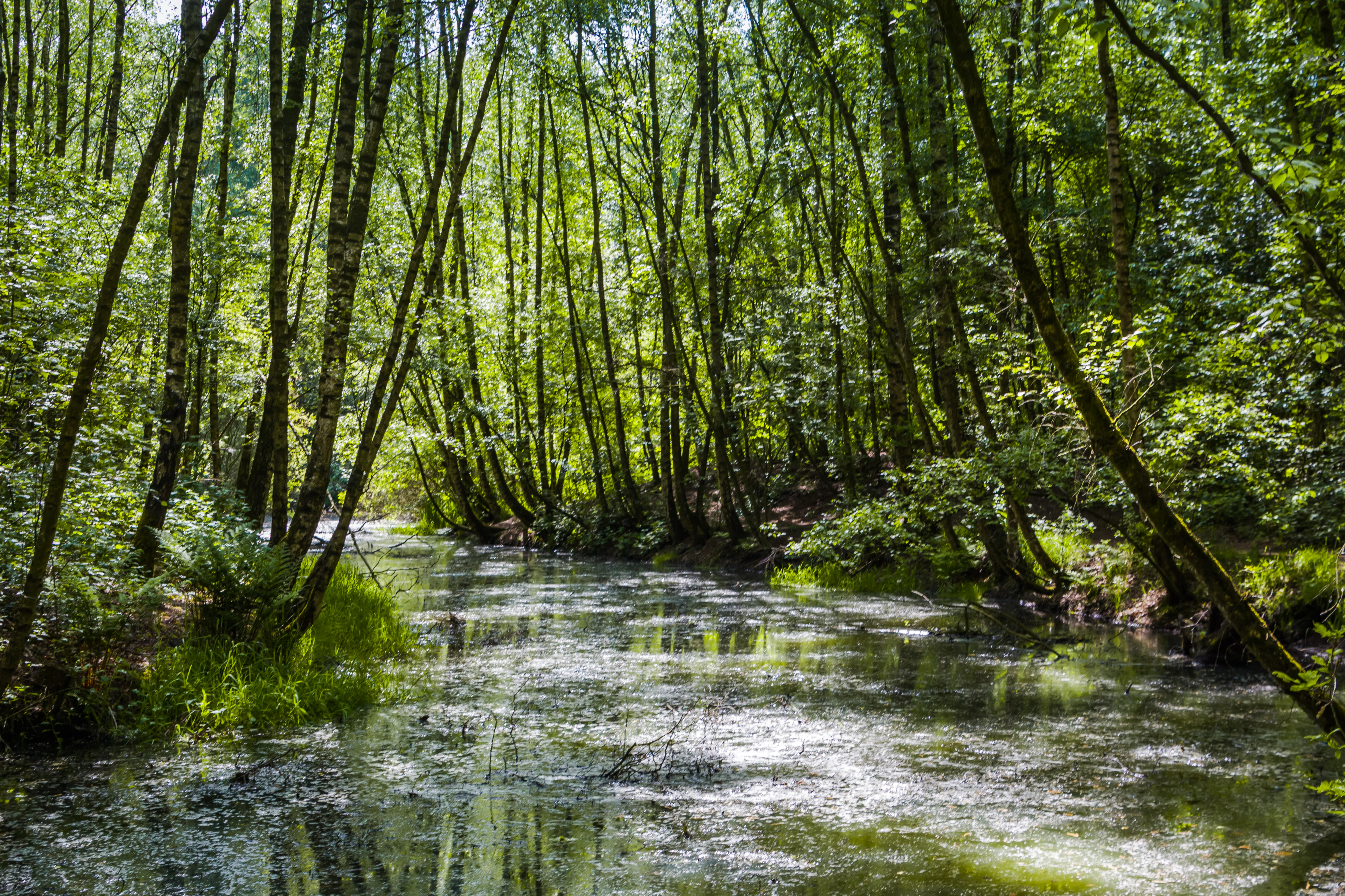
A calm, shallow body of water in a forest, with slender trees growing along the banks and green vegetation reflecting on the surface.
A shaded pond surrounded by lush forest in the Uni-Wildnis nature reserve.

Am Stadtwaldsee (Uni-Wildnis) history and protected-area timeline

The reserve's history is closely tied to mid-20th-century infrastructure development in Bremen. During the construction of the University of Bremen and the expansion of the Bundesautobahn 27, large volumes of sand were needed. Extraction activities produced the basin that would become the larger Stadtwaldsee, and the surrounding land that was disturbed and used for spoil deposition was simply left in place after the construction work concluded.

Over the following years, this abandoned terrain slowly developed its own ecological character, transitioning from an industrial disturbance site into a complex of ponds and woodland through natural vegetation succession. By the early 1980s, local conservation efforts had identified the area as ecologically promising, and parts of it were enclosed with a ring ditch to formalize the boundaries of what would become the protected zone.

Official nature reserve status was granted on 16 March 1991, and the area was registered as Bremen nature reserve number 11. The legal category applied to the site reflects its role as a Habitat/Species Management Area under the IUCN system, emphasizing its function in supporting specific habitats rather than as a strictly wilderness-type protected landscape. Maintenance of the reserve has been supported by the volunteer association Freunde der Uniwildnis, which has handled practical care including the regular removal of litter that drifts in from the nearby intensively used Stadtwaldsee recreation area.

Am Stadtwaldsee (Uni-Wildnis) landscape and geographic character

The landscape of Am Stadtwaldsee (Uni-Wildnis) is shaped by a tight mosaic of ponds, wetland margins, and woodland, all compressed into just over eleven hectares. Its most defining feature is a series of small ponds, the result of historical sand extraction that once supplied construction projects in the wider Bremen area. These water bodies are surrounded by wooded ground that helps frame the reserve visually and ecologically.

In geographic terms, the reserve sits south of the Bundesautobahn 27, with the extensive Bremen Stadtwald forest to its north and east, a camping area to the east, and another camping ground along with the larger Stadtwaldsee lake to the west. This positioning means the reserve is an island-like patch of habitat bordered by forest on one side and recreational landscapes on the other.

The terrain itself is low-lying and soft, characteristic of the sandy soils typical of the region. The presence of the ring ditch enclosing the core area reinforces the wetland character and helps maintain the water levels and moisture gradients that define much of the reserve's identity. Although compact, the landscape contains visible microhabitat variation, with open water, damp marginal zones, and shaded forest patches transitioning into one another within very short distances.

Am Stadtwaldsee (Uni-Wildnis) ecosystems, habitats, and plant life

Ecologically, Am Stadtwaldsee (Uni-Wildnis) functions as a small but rich secondary habitat, an ecosystem that has arisen from earlier human disturbance rather than from an undisturbed natural baseline. Because the area was once an active extraction and spoil site, the soils and topography reflect the imprint of human activity, yet ecological succession over multiple decades has allowed complex vegetation patterns and water-based microhabitats to develop.

The reserve's combination of several ponds and adjoining woodland gives it a layered ecological structure. The ponds provide open-water habitat and wetland margins where moisture-loving plant communities can establish, while the surrounding forest contributes shaded interior habitat with leaf litter, deadwood, and mature tree cover. Together these elements create a compact habitat mosaic that supports a wide range of species relative to the area's size.

The fact that the reserve sits within a dense urban setting makes this ecological heterogeneity particularly important. Surrounded by motorways, recreational areas, and residential neighborhoods, the site serves as a refuge where species can feed, breed, and shelter without the constant pressure of intensive land use. This makes it valuable both as a standalone habitat and as a stepping stone within Bremen's broader network of small nature reserves.

Am Stadtwaldsee (Uni-Wildnis) wildlife and species highlights

While the source documentation does not enumerate specific species, the reserve's ecological structure points clearly to the kinds of wildlife it supports. The ponds attract amphibians such as frogs and newts, whose life cycles depend on the open water, while the wetland margins and adjacent woodland provide habitat for invertebrates, reptiles, and small mammals. The forest patches, with their mature trees and deadwood, create niches for woodland birds and other species that depend on sheltered, semi-natural conditions.

The reserve's role as a refuge is reinforced by the maintenance work of the Freunde der Uniwildnis association. Their regular cleanup efforts, particularly important because the reserve borders the heavily used Stadtwaldsee, help reduce litter pressure that could otherwise harm both aquatic and terrestrial wildlife. The exclusion of activities such as open fires and plant removal, as set out in the reserve's protection ordinance, further supports the integrity of wildlife habitat within the small area.

Am Stadtwaldsee (Uni-Wildnis) conservation status and protection priorities

Am Stadtwaldsee (Uni-Wildnis) holds recognized conservation significance as Bremen nature reserve number 11, formally designated on 16 March 1991 under the city's Naturschutzgebietsverordnung. It is classified in the IUCN system as Category IV, a Habitat/Species Management Area, indicating that its primary purpose is the conservation of particular habitats and species rather than the protection of a broad wilderness.

The reserve's conservation value lies especially in its character as a secondary habitat. Because the area arose from abandoned sand-extraction pits and spoil grounds used during major construction projects, it demonstrates how former industrial sites can, with time and minimal intervention, develop into ecologically valuable landscapes. This makes Am Stadtwaldsee both a functional refuge for urban biodiversity and a reference example for secondary habitat preservation.

Coordination of conservation management involves the University of Bremen as landowner, the Senator for Environment, Climate and Science as the responsible authority, and the volunteer group Freunde der Uniwildnis as on-the-ground stewards. The protection ordinance restricts potentially damaging activities such as open fires and the removal of plants from the area. Beyond its local conservation function, the reserve participates in the broader network of Bremen's nature reserves, including wetlands and bird protection areas that collectively maintain ecological connectivity across the city-state.

Am Stadtwaldsee (Uni-Wildnis) cultural meaning and human context

The cultural identity of Am Stadtwaldsee (Uni-Wildnis) is closely tied to the history of the University of Bremen and the growth of Horn-Lehe as a city district. The reserve exists, in a literal sense, because of the university's construction; the sand pits that later became the area's ponds were originally excavated to support that development. This creates a distinctive local narrative in which a piece of academic infrastructure is also the indirect creator of an urban nature reserve.

The volunteer association Freunde der Uniwildnis embodies a strong culture of community-led stewardship. Through memberships and donations, local residents take direct responsibility for the upkeep of the reserve, an arrangement that reflects Bremen's broader tradition of civic engagement in environmental protection. The reserve is also part of the city's wider cultural-geographic story, situated at the edge of the much larger Stadtwald forest and recreational landscape that defines Horn-Lehe's outdoor identity.

Top sights and standout views in Am Stadtwaldsee (Uni-Wildnis)

The reserve's standout qualities are its compact mosaic of ponds and forest, its origin as a textbook secondary habitat formed by former sand extraction, and its active community stewardship model. Within Bremen's urban fabric, Am Stadtwaldsee stands out as one of the few protected areas whose identity is directly tied to the legacy of university and motorway construction.

The presence of multiple small ponds within just over eleven hectares gives the reserve a high habitat-to-area ratio, while its ring ditch and protection ordinance maintain the hydrological and ecological conditions that define its character. The combination of ecological value, citizen-led management, and an unusual origin story makes it a distinctive piece of Bremen's network of nature reserves.

Best time to visit Am Stadtwaldsee (Uni-Wildnis)

Given its small size and urban setting, Am Stadtwaldsee is largely accessible year-round as part of broader walks through the Bremen Stadtwald and around the Stadtwaldsee lake. Spring and early summer are particularly rewarding for observing the reserve at its most active biologically, when pond margins are full and woodland vegetation is in full leaf. Autumn brings rich forest colour and damper conditions that emphasize the wetland character of the area. Visitors should expect that this is a quiet local nature reserve rather than a major visitor attraction; its appeal lies in observing a small, well-kept secondary habitat within the city.


Monthly climate preview

Long-term representative point measurements for annual temperature and precipitation

Am Stadtwaldsee (Uni-Wildnis) Climate Normals and Temperature Rhythms

Am Stadtwaldsee (Uni-Wildnis) records a measured annual temperature and precipitation rhythm across twelve baseline months at a representative coordinate. Reviewing the complete monthly profile provides deeper context on long-term climate normals and seasonal variations.
Annual mean9 °C
1 °C18 °C
Jan
Feb
Mar
Apr
May13°
Jun16°
Jul18°
Aug18°
Sep14°
Oct10°
Nov
Dec
Warmest month
July

18 °C

Coolest month
January

1 °C

Wettest month
July

2.5 mm/day

Driest month
April

1.4 mm/day

Park location guide

Geography guide, regional context, and park location map for Am Stadtwaldsee (Uni-Wildnis)

Am Stadtwaldsee (Uni-Wildnis) park geography, regions, and map view in Germany

Understand where Am Stadtwaldsee (Uni-Wildnis) sits in Germany through a broader geographic reading of the surrounding landscape, nearby location context, and its mapped position within the national park landscape.

How Am Stadtwaldsee (Uni-Wildnis) fits into Germany

Germany is a federal republic in Western and Central Europe with a population of over 83 million across sixteen constituent states. It is Europe's largest economy by nominal GDP and a major global exporter and importer. The capital is Berlin, and the country borders Denmark, Poland, Czech Republic, Austria, Switzerland, France, Luxembourg, Belgium, and the Netherlands.

Wider geography shaping Am Stadtwaldsee (Uni-Wildnis) in Germany

Germany is located in Western and Central Europe, spanning 357,022 km². It borders Denmark to the north, Poland and the Czech Republic to the east, Austria and Switzerland to the south, and France, Luxembourg, Belgium, and the Netherlands to the west. The country has coastlines on the Baltic Sea and North Sea to the north, with the Alps located in the southern region.

Map view of Am Stadtwaldsee (Uni-Wildnis)

Use this park location map to pinpoint Am Stadtwaldsee (Uni-Wildnis) in Germany, understand its exact geographic position, and read its mapped placement within the surrounding landscape more clearly.

Pigeon | © OpenStreetMap contributors

Location context for Am Stadtwaldsee (Uni-Wildnis)

Bremen

Examine the secondary habitat landscapes, woodland patches, and wetland terrain.

Visual Exploration of Am Stadtwaldsee (Uni-Wildnis) Photos and Scenery

Visual records capture the compact mosaic of ponds, wetland margins, and forest patches defining the urban protected area. Photographic documentation reveals the distinct terrain and secondary habitat characteristics shaped by historical sand extraction in Bremen.

A calm, shallow body of water in a forest, with slender trees growing along the banks and green vegetation reflecting on the surface.

Park atlas

Compare surrounding nature reserves and urban wildlife refuges across northwestern Germany

Parks Near Am Stadtwaldsee (Uni-Wildnis) And Protected Areas In The Region

Browse nearby protected landscapes and secondary habitats situated around Am Stadtwaldsee (Uni-Wildnis). Expanding geographic comparison reveals interconnected regional park networks and urban conservation areas.
Nature reserveBremen
About 0.4 km away#1 closest

Northeast

Kuhgrabensee Nature Reserve: Mapped Geography and Protected Areas in Bremen

An ecologically vital lake and bird sanctuary in Northwest Germany

Kuhgrabensee serves as a prime example of landscape restoration within Bremen, featuring a groundwater-fed lake with notable saline influences. This protected area supports a diverse array of pioneer plants and wildlife across its reed-lined shores and shallow-water habitats, providing a quiet corridor for ecological observation and study in the heart of the local landscape.

Area
0.296 km²
Established
1987
Relief
Lowland
Climate
Temperate
A soft, painterly watercolor illustration depicting a winding river through a flat green meadow with rolling hills in the background.
Nature reserveBremen
About 0.9 km away#2 closest

East

Hollerland Nature Reserve: A Protected Cultural Landscape and Wetland in Bremen

Historic marshland terrain with unique saline spring ecosystems

Hollerland is a 293-hectare nature reserve in Bremen, Germany, notable for its well-preserved cultural landscape of wet grasslands and an intricate medieval ditch network. This protected area serves as a critical breeding ground for meadow birds and hosts an ecologically significant inland saline spring, providing a rare habitat for brackish-adapted plant communities deep within the regional landscape.

Area
2.93 km²
Established
1985
IUCN
IV
Relief
Lowland
Nature reserveBremen
About 2.6 km away#3 closest

North

Untere Wümme Nature Reserve: Riverine Biodiversity and Protected Tidal Landscapes in Bremen

Protected floodplain geography and tidal river habitats.

This nature reserve protects the meandering lower course of the Wümme river, showcasing one of northern Germany's few freshwater tidal systems. Spanning reedbeds, willow forests, and open mudflats, the reserve forms a vital corridor for migratory fish and waterfowl, reflecting a complex mosaic of protected riverine ecosystems and historic meadow landscapes.

Area
1.485 km²
Established
1991
Relief
Lowland
Climate
Temperate
A pale, soft-toned watercolor illustration of a calm river meandering through open, green marshy meadows with distant rolling hills under a soft pink sky.
Nature reserveBremen
About 4.5 km away#4 closest

East

Borgfelder Wümmewiesen: Protected Wetland and Floodplain Geography in Bremen

An expansive 688-hectare nature reserve with river-fed grasslands.

Borgfelder Wümmewiesen offers a look at one of the largest protected nature reserves in the Bremen region. The landscape is characterized by its flat, open terrain and regular water dynamics that frame a rich mosaic of wet meadows, reedbeds, and ponds, providing essential habitat for breeding and migratory bird species along the Wümme river corridor.

Area
6.88 km²
Established
1987
Relief
Lowland
Climate
Temperate
A watercolor painting showing a soft, panoramic view of a flat wetland area with green trees, a solitary tree in the middle, and industrial silos faintly visible in the background.
Nature reserveBremen
About 7.5 km away#5 closest

West

Hochwasserschutzpolder zwischen Senator-Apelt-Straße und Neustädter Hafen: Bremen Protected Lands

A vital wetland reserve integrating flood management and avian biodiversity in the port district.

Located within the port district of Bremen, the Hochwasserschutzpolder zwischen Senator-Apelt-Straße und Neustädter Hafen is a notable protected area that balances essential flood-control infrastructure with rich ecological functions. The reserve sustains a variety of wetland bird populations across its reed-lined waters and alluvial woodlands, providing a critical haven for wildlife amidst the surrounding industrial and urban development of the Lower Weser region.

Area
0.847 km²
Established
2014
IUCN
IV
Nature reserveBremen
About 7.9 km away#6 closest

South

Vogelschutzgebiet Arsten-Habenhausen: Mapping the Protected Weser Floodplain Habitat

A historic urban nature reserve located in Bremen

Located in the Habenhausen district of Bremen, Vogelschutzgebiet Arsten-Habenhausen is a significant protected area focused on river floodplain maintenance. The site provides a concentrated view of floodplain woodland and reedbed vegetation, illustrating how small, long-established nature reserves contribute to the regional geography of the Weser river corridor in Germany.

Area
0.01 km²
Established
1950
IUCN
IV
Relief
Lowland
A horizontal watercolor painting showing a tranquil lake scene with green trees, low-lying hills in the distance, and grassy banks against a white background.
Nature reserveBremen
About 8.5 km away#7 closest

Northwest

Grambker Feldmarksee Nature Reserve: Mapping the Protected Landscapes of Bremen

A vital wetland sanctuary shaped by regional infrastructure and natural restoration

Grambker Feldmarksee offers a focused look at how post-industrial quarry sites evolve into ecologically dense nature reserves. This groundwater-fed lake in Bremen acts as a green island, showcasing mature woodland fringes and specialized wetland habitats that are integral to the local bird protection network.

Area
0.226 km²
Established
2009
Relief
Lowland
Climate
Temperate
Nature reserveBremen
About 9.1 km away#8 closest

Southwest

Ochtumniederung bei Brokhuchting: Wetland Nature Reserve and Floodplain Geography

A core conservation area within the Bremen Niedervieland

This protected area stands as a primary example of large-scale river floodplain restoration in the Bremen region. The landscape includes a dense network of canals, reedbeds, and seasonal flood zones that provide critical shelter for waterfowl and waders. Through careful environmental management, this site integrates natural riverine terrain with the surrounding industrial and urban framework of northwestern Germany, offering a distinct study of managed wetland ecosystems.

Area
3.75 km²
Established
1998
Relief
Lowland
Climate
Temperate

Common questions about visiting, size, designation, and location context for Am Stadtwaldsee (Uni-Wildnis)

Am Stadtwaldsee (Uni-Wildnis) FAQs for park facts, access, geography, and protected area context

Find quick answers about Am Stadtwaldsee (Uni-Wildnis), including protected-area facts, park geography, trail and visitor context, and how the park fits into its surrounding country and regional landscape.
MoriAtlas Explorer

Continue Your Protected Areas Search Across the Global Atlas

Deepen your exploration by continuing the structured search for national parks and protected areas worldwide. Utilize the comprehensive filtering capabilities to compare different conservation landscapes and refine your understanding of global park geography. Discover more about the distribution and characteristics of protected natural areas.

Global natural geography