
Mori Atlas logo
Nature reserveAmerikafeld und Schindkaute bei Steinheim

Tracing the mapped boundaries and ice-age terrain of this rare metropolitan nature reserve.

Amerikafeld und Schindkaute bei Steinheim: A Protected Sand Dry Grassland in Hessen

Amerikafeld und Schindkaute bei Steinheim stands as a vital nature reserve and Natura 2000 site within the Rhine-Main metropolitan area. This protected landscape preserves rare sand dry grassland habitats formed by wind-deposited ice-age sands, maintained through traditional sheep grazing to support specialized flora and fauna. The area offers a significant example of open, nutrient-poor terrain amidst the surrounding urban and infrastructure development.

sand dry grasslandSandtrockenrasenNatura 2000FFH siteHeublein conservationHesse
An illustration in a flat, stylized graphic art style showing a wide valley with pine trees in the foreground, steep mountain cliffs in the background, and a central tiered waterfall.

Amerikafeld und Schindkaute bei Steinheim

Nature reserve

Park overview

Structured park overview, official facts, and landscape profile for Amerikafeld und Schindkaute bei Steinheim

Amerikafeld und Schindkaute bei Steinheim park facts, protected area profile, and essential visitor context

Review the core facts for Amerikafeld und Schindkaute bei Steinheim, including designation, size, terrain, visitor scale, habitats, and operating context in one park-focused overview.

About Amerikafeld und Schindkaute bei Steinheim

Amerikafeld und Schindkaute bei Steinheim is a small but ecologically valuable protected area situated in the northwestern part of the city of Hanau, in the state of Hesse. Although it lies close to residential neighborhoods and busy transport routes, the reserve preserves a landscape type that has almost entirely disappeared from the surrounding Rhine-Main region: open sand dry grassland on wind-deposited sands from the last ice age.

The area is documented under the German nature reserve identifier 1435077 and is recorded internationally in the World Database on Protected Areas. As part of the European Union's Natura 2000 network, it also forms the core of the larger FFH site "Amerikafeld, Schindkaute und Gailenberg" (DE5819303), which extends protection to an adjacent protected landscape component known as the Gailenberg near Hanau-Steinheim.

Ecologically, the reserve is characterized by its impoverished, sandy soils and by the open, grass-dominated vegetation that thrives on them. These conditions support a specialized community of plants and animals, including silver grass and the dune tiger beetle, that would not survive in shaded or nutrient-enriched habitats. The continued open character of the grassland is maintained through traditional sheep grazing carried out by a local shepherd, a practice that mirrors the historical land use that originally shaped the site.

The reserve is also notable for the circumstances of its establishment. Before it was formally protected, developers attempted to purchase the entire site in order to build commercial facilities, hoping to create a fait accompli before the area received official protection. This pressure led the Darmstadt regional council to issue an interim protection order in April 1992, and the area was finally designated as a Naturschutzgebiet in 1995. Today the site stands as a small but meaningful example of how a rare habitat can be retained even in close proximity to a major urban region.

Quick facts and research context for Amerikafeld und Schindkaute bei Steinheim

Amerikafeld und Schindkaute bei Steinheim is a nature reserve in the urban area of Hanau, Hesse, classified under code 1435077 and recorded in the World Database on Protected Areas as WDPA 162197. The protected area covers around 16 hectares and was officially designated as a Naturschutzgebiet in 1995, following an interim protection order issued by the Darmstadt regional council in 1992.

The site is also part of the European Natura 2000 network as the FFH site "Amerikafeld, Schindkaute und Gailenberg" (DE5819303), which extends protection to roughly 20 hectares including the adjacent Gailenberg protected landscape component. The reserve protects one of the last sand dry grasslands in the Rhine-Main region, a habitat shaped by ice-age sand deposits and maintained by traditional grazing.

Protection and recognition

Documented protection frameworks, Natura 2000 listings, and official administrative records

Amerikafeld und Schindkaute bei Steinheim Protection Status and International Recognition Records

Amerikafeld und Schindkaute bei Steinheim maintains documented protection status through verified Natura 2000 network listings and administrative boundary records. Structured international recognition data outlines official conservation frameworks associated with the protected area.
Park context

Deeper park guide and search-rich context for Amerikafeld und Schindkaute bei Steinheim

Amerikafeld und Schindkaute bei Steinheim history, landscape, wildlife, and travel context

Explore Amerikafeld und Schindkaute bei Steinheim through its history, landscape character, ecosystems, wildlife, conservation priorities, cultural context, and seasonal travel timing in a structured park guide built for atlas discovery and search intent.

Why Amerikafeld und Schindkaute bei Steinheim stands out

Amerikafeld und Schindkaute bei Steinheim is best known for protecting a rare fragment of sand dry grassland (Sandtrockenrasen) in the otherwise heavily developed Rhine-Main area. The reserve's defining character is the open, sandy terrain that originated during the last ice age and has persisted through long-term grazing by sheep. The site is recognized for its specialized dry grassland flora and fauna, including silver grass (Silbergras) and the dune tiger beetle (Dünen-Sandlaufkäfer), both of which depend on the warm, nutrient-poor sandy soil that defines the habitat. The combination of geological origin, traditional land use, and adjacency to a major urban region gives the reserve its distinctive identity as a preserved open landscape island within a metropolitan setting.
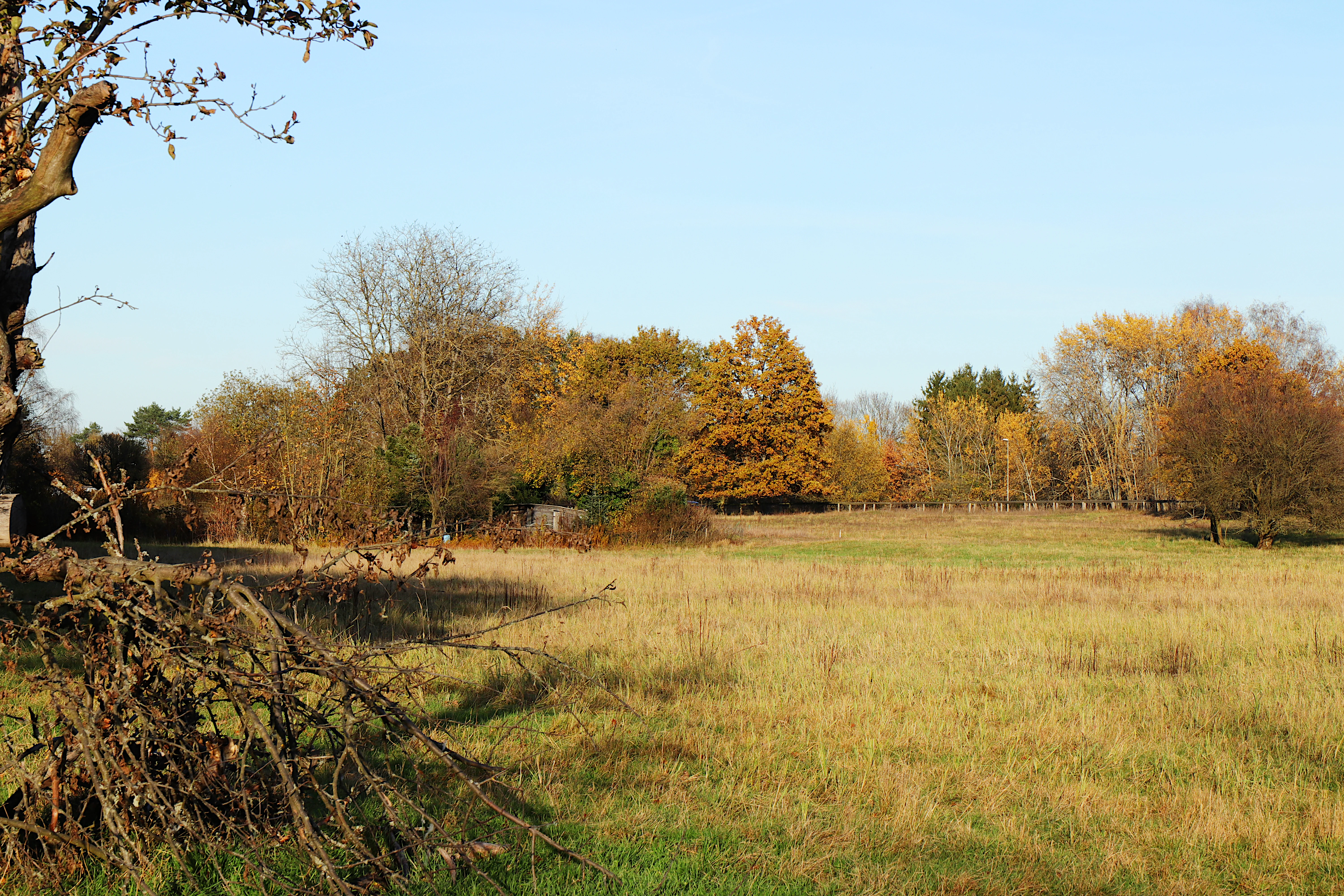
A wide view of a dry meadow with tall, yellowish grasses leading to a dense line of trees with autumn foliage under a clear blue sky.
A view of the sandy dry grassland habitat within the Amerikafeld und Schindkaute nature reserve during autumn.

Amerikafeld und Schindkaute bei Steinheim history and protected-area timeline

The landscape that Amerikafeld und Schindkaute bei Steinheim protects is ancient in geological terms: the underlying sands were laid down during the last ice age, when wind action shaped the surface of what is now the Rhine-Main region. For centuries the open grassland character of the site was maintained by grazing, a practice that prevented woodland from establishing itself on the dry, nutrient-poor sandy soils.

In the late twentieth century, however, the reserve's history became shaped by urban development pressure from the expanding city of Hanau. Investors attempted to acquire the entire area in order to construct commercial buildings, with the goal of creating "completed facts" before any protective designation could be finalized and then profiting from the resulting building land. In response, the Darmstadt regional council (Regierungspräsidium Darmstadt), acting as the higher nature conservation authority, issued an order on 6 April 1992 for the provisional safeguarding of the area.

This interim protection paved the way for formal designation. In 1995, the area was officially declared a Naturschutzgebiet under the identifier 1435077. Shortly afterwards, in 1991 and later years, the adjacent Gailenberg near Hanau-Steinheim was designated as a protected landscape component, and the combined area was incorporated into the European Natura 2000 network as the FFH site "Amerikafeld, Schindkaute und Gailenberg". The reserve continues to be managed through traditional sheep grazing, which remains essential to preventing forest encroachment on the dry grassland.

Amerikafeld und Schindkaute bei Steinheim landscape and geographic character

The landscape of Amerikafeld und Schindkaute bei Steinheim is defined by its dry, sandy character. The terrain consists of wind-deposited sands from the last ice age, producing a gently undulating surface with nutrient-poor, well-drained soils. Unlike the surrounding Rhine-Main region, which is dominated by forests, settlements, agricultural fields, and infrastructure, the reserve presents an open, sunny, and steppe-like impression within an otherwise heavily used landscape.

The reserve sits west of the Steinheim district of Hanau, bounded to the south by district road K 213 and to the west by the federal road B 45. Despite this proximity to transport corridors and residential areas, the open sandy grassland remains visually distinct, with low-growing vegetation, sparse ground cover, and patches of bare sand visible across the terrain.

Adjacent to the main reserve, the Gailenberg adds a slightly different landscape element to the protected complex. This area features older fruit tree stands growing on sandy grassland slopes, creating a transition between the open sand dry grassland of Amerikafeld and Schindkaute and the more structured rural landscape of the region.

Amerikafeld und Schindkaute bei Steinheim ecosystems, habitats, and plant life

Ecologically, Amerikafeld und Schindkaute bei Steinheim is dominated by Sandtrockenrasen, or sand dry grassland. This habitat type is characterized by low-growing, drought-adapted vegetation on nutrient-poor, acidic sandy soils. Because the substrate retains little moisture and few nutrients, only specialized plant species can thrive, and this selective pressure produces a distinctive botanical community.

Silver grass (Silbergras) is one of the characteristic plant species of the reserve, reflecting the close relationship between the site's flora and its sandy substrate. The open nature of the habitat also creates warm, exposed microclimates near the ground, which favor thermophilic insects and other invertebrates adapted to dry conditions.

Beyond the central sand dry grassland, the broader FFH site includes the Gailenberg, where fruit tree stands grow on sand grassland slopes. This creates a mosaic of dry grassland and traditional orchard habitat, supporting a slightly broader range of species than the open sand areas alone, while still preserving the overall character of a sandy, sun-exposed landscape.

Amerikafeld und Schindkaute bei Steinheim wildlife and species highlights

The wildlife of Amerikafeld und Schindkaute bei Steinheim is shaped by its dry, open, sandy conditions. Invertebrates make up a particularly important share of the site's biodiversity, because the warm microclimate created by bare sand and low vegetation is ideal for species that depend on heat and dry substrate. The dune tiger beetle (Dünen-Sandlaufkäfer) is one of the reserve's signature species, an insect that requires exactly the kind of open, sandy terrain that the reserve protects.

The presence of such specialized insects is itself a signal that the habitat quality of the reserve remains high. In surrounding areas, where sandy soils have been built over, afforested, or otherwise altered, populations of these heat-loving species have declined sharply, leaving the reserve as a refuge for the regional fauna.

Larger vertebrates are not the focus of the reserve, and the open nature of the grassland, maintained through grazing, means that woody cover is intentionally limited. Sheep grazing, carried out by a local shepherd, plays a direct role in shaping habitat conditions for ground-dwelling insects and other species that depend on open sand surfaces.

Amerikafeld und Schindkaute bei Steinheim conservation status and protection priorities

From a conservation perspective, Amerikafeld und Schindkaute bei Steinheim is significant because it preserves one of the last surviving examples of sand dry grassland in the Rhine-Main region. Sandtrockenrasen is a habitat that depends on a combination of geological inheritance, in the form of ice-age sand deposits, and continued open land use. Once trees establish themselves or the soil is altered by development, the specialized communities of plants and animals associated with this habitat disappear quickly.

The reserve is designated at multiple levels. It is registered as a German Naturschutzgebiet under code 1435077, it appears in the World Database on Protected Areas as WDPA 162197, and it forms the core of the Natura 2000 / FFH site "Amerikafeld, Schindkaute und Gailenberg" (DE5819303). Together these designations reflect both national and European recognition of its conservation value.

Its establishment in 1995 was the result of active intervention against development pressure, after the Darmstadt regional council issued an interim protection order in 1992. The reserve's continued grazing management, in which a local shepherd uses sheep to prevent woodland regeneration, is essential to maintaining the conservation value of the site over the long term.

Amerikafeld und Schindkaute bei Steinheim cultural meaning and human context

The cultural context of Amerikafeld und Schindkaute bei Steinheim is closely tied to traditional land use in the Rhine-Main region. The open character of the sand grassland has been shaped and maintained by grazing for generations, and the practice of moving sheep across these dry, sandy soils is part of the agricultural heritage of the area around Hanau.

The name "Amerikafeld" reflects local toponymy rooted in regional history and land use rather than any direct reference to the American continent. Names of this kind are common in the Hesse region, where field and parcel names preserve layers of historical, linguistic, and cultural meaning.

The reserve also reflects modern urban conservation culture. Its protection was driven by the recognition that even small, residual patches of unusual habitat near cities have lasting ecological value, and that proactive intervention, including interim protection orders, can preserve these sites against development pressures. The continued involvement of a local shepherd in managing the grassland links the reserve's ecological identity to the surrounding rural community.

Top sights and standout views in Amerikafeld und Schindkaute bei Steinheim

Amerikafeld und Schindkaute bei Steinheim stands out as one of the last sand dry grasslands in the Rhine-Main metropolitan region, an open, sandy habitat shaped by ice-age deposits and centuries of grazing. Its protected status spans German Naturschutzgebiet designation, European Natura 2000 recognition, and inclusion in the global protected areas database, reflecting the unusual ecological value of a small but rare ecosystem.

The reserve is home to specialized species such as silver grass and the dune tiger beetle, which depend on the warm, dry, open conditions that the site preserves. Its management, based on sheep grazing, links ecological conservation with traditional land use, making the reserve a small but instructive example of how rare open habitats can be maintained near major urban areas.

Best time to visit Amerikafeld und Schindkaute bei Steinheim

Because Amerikafeld und Schindkaute bei Steinheim is a low-lying, open sand grassland with little tree cover, the warmer and drier months of late spring and summer are generally the most rewarding time to experience the reserve. During this period the sandy soils are dry, the vegetation is in active growth, and the heat-loving invertebrates for which the site is known are most likely to be active.

In cooler or wetter seasons the grassland remains ecologically present, but its open, sunny character is less pronounced. Visitors interested in observing the full ecological profile of the reserve, including its specialized plant and insect communities, will generally find the warmer half of the year most informative.

Monthly climate preview

Long-term monthly temperature averages and precipitation measurements for Hessen protected terrain

Amerikafeld und Schindkaute bei Steinheim Climate Normals and Annual Temperature Patterns

Representative coordinate sampling records long-term temperature ranges and daily precipitation patterns across the protected landscape throughout the year. Examining the full monthly data profile provides complete statistical context for twelve-month climate variations.
Annual mean10 °C
0 °C21 °C
Jan
Feb
Mar
Apr10°
May14°
Jun18°
Jul21°
Aug20°
Sep15°
Oct10°
Nov
Dec
Warmest month
July

20.6 °C

Coolest month
January

0.2 °C

Wettest month
July

2.2 mm/day

Driest month
April

1.4 mm/day

Park location guide

Geography guide, regional context, and park location map for Amerikafeld und Schindkaute bei Steinheim

Amerikafeld und Schindkaute bei Steinheim park geography, regions, and map view in Germany

Understand where Amerikafeld und Schindkaute bei Steinheim sits in Germany through a broader geographic reading of the surrounding landscape, nearby location context, and its mapped position within the national park landscape.

How Amerikafeld und Schindkaute bei Steinheim fits into Germany

Germany is a federal republic in Western and Central Europe with a population of over 83 million across sixteen constituent states. It is Europe's largest economy by nominal GDP and a major global exporter and importer. The capital is Berlin, and the country borders Denmark, Poland, Czech Republic, Austria, Switzerland, France, Luxembourg, Belgium, and the Netherlands.

Wider geography shaping Amerikafeld und Schindkaute bei Steinheim in Germany

Germany is located in Western and Central Europe, spanning 357,022 km². It borders Denmark to the north, Poland and the Czech Republic to the east, Austria and Switzerland to the south, and France, Luxembourg, Belgium, and the Netherlands to the west. The country has coastlines on the Baltic Sea and North Sea to the north, with the Alps located in the southern region.

Map view of Amerikafeld und Schindkaute bei Steinheim

Use this park location map to pinpoint Amerikafeld und Schindkaute bei Steinheim in Germany, understand its exact geographic position, and read its mapped placement within the surrounding landscape more clearly.

Pigeon | © OpenStreetMap contributors

Location context for Amerikafeld und Schindkaute bei Steinheim

Hessen
Recorded earthquake history

Explore Historical Earthquake Records for Amerikafeld und Schindkaute bei Steinheim

Gain insight into regional seismic history by reviewing the documented earthquake records associated with Amerikafeld und Schindkaute bei Steinheim. This MoriAtlas catalogue provides event-specific data including magnitude and epicenter distance to help contextualize the environment surrounding this protected nature reserve.

Amerikafeld und Schindkaute bei Steinheim Earthquake Records

Catalogued events

16 events

Strongest magnitude

Magnitude 3.8

Most recent event

May 17, 2014

This history includes earthquakes recorded inside the park or within 50 km of its borders

Visual reference collection showcasing rare sand dry grassland habitats, open sandy terrain, and unique reserve scenery

Amerikafeld und Schindkaute bei Steinheim Photos and Protected Landscape Views

Visual records capture the open sandy terrain, sparse ground cover, and specialized vegetation defining Amerikafeld und Schindkaute bei Steinheim. Photographic documentation provides direct insight into the protected ecosystem and rare regional landscape characteristics.

A wide view of a dry meadow with tall, yellowish grasses leading to a dense line of trees with autumn foliage under a clear blue sky.

Park atlas

Compare nearby regional reserves and connected sandy grassland habitats.

Explore Protected Areas Near Amerikafeld und Schindkaute bei Steinheim

Browse protected areas and natural reserves located near Amerikafeld und Schindkaute bei Steinheim in the Rhine-Main region. Comparing these surrounding landscapes provides a broader geographic perspective on regional conservation habitats and protected terrain.
A soft watercolor painting of a serene landscape featuring a central body of water surrounded by green banks, shrubs, and gentle rolling hills in the background.
Nature reserveHessen
About 0.8 km away#1 closest

Northwest

Oberwaldsee von Dietesheim Nature Reserve: Atlas and Geographic Landscape Overview

Protected basalt terrain in the Hessen region

Discover the geographic character of Oberwaldsee von Dietesheim, a protected nature reserve in Hessen defined by flooded basalt quarries and open sandy dry-grassland. This site serves as a vital ecological stepping stone within the Untermain lowlands, offering a study in microtopography and habitat diversity. Access detailed mapping and protected-area context for this essential German nature reserve within the Rhine-Main metropolitan corridor.

Area
0.335 km²
Established
1989
IUCN
IV
Nature reserveLandkreis Offenbach
1.1 km away#2 closest

West

Mayengewann von Lämmerspiel: Nature Reserve and Protected Landscape in Landkreis Offenbach

Oak woodlands and rare orchid meadows within the Rhine-Main landscape

Examine the geography of Mayengewann von Lämmerspiel, a significant nature reserve characterized by its mosaic of old oak forest and moist grassland. This site acts as an ecological refuge in Landkreis Offenbach, safeguarding rare species such as the fen violet, adder's-tongue fern, and multiple orchid varieties within a carefully managed protected boundary.

Area
0.067 km²
Established
1985
IUCN
IV
Relief
Lowland
A horizontal watercolor painting showing a stylized, layered forest scene in muted green, pink, and yellow tones on a white background.
Nature reserveHesse
About 1.4 km away#3 closest

South

Lauternsee bei Klein-Auheim Nature Reserve: Geography and Protected Bog Landscape

A historic high terrace habitat within the Hesse woodland region.

Lauternsee bei Klein-Auheim represents a specialized Flachmoor habitat that emerged from a former river channel of the Main. This nature reserve serves as an important ecological anchor in the lower Main valley, protecting essential wetlands, amphibian populations, and unique marsh plant communities within an expansive forest setting.

Established
1987
A wide watercolor illustration depicting a green wetland landscape with reed beds, grasses, and distant hills under a pale sky.
Nature reserveHessen
About 3.8 km away#4 closest

South

Gräbenwäldchesfeld von Hausen: Nature Reserve and Protected Wetland Landscape Geography

Mapping rare meadow ecosystems in the Hessen region

Gräbenwäldchesfeld von Hausen functions as a critical protected nature reserve, safeguarding species-rich wet meadows and moisture-dependent flora in the town of Obertshausen. This atlas entry details the site's role within the Landkreis Offenbach, focusing on the preservation of reed beds and marsh landscapes amidst a predominantly urbanized terrain.

Area
0.054 km²
Established
1990
IUCN
IV
Relief
Lowland
Nature reserveHesse
About 5.6 km away#5 closest

Southwest

Im Woog von Hainstadt Nature Reserve: Regional Geography and Protected Landscape Atlas

Mapping floodplain habitats in the Lower Main plain of Hesse

Im Woog von Hainstadt is a structurally diverse nature reserve located in Hainstadt, Germany. The site protects a compact floodplain mosaic consisting of deciduous woodland, wet meadows, and dry grasslands on a former river meander. Adjacent to the Wildpark Alte Fasanerie, the reserve functions as a biodiversity hotspot, offering essential habitat within the developed eastern Lower Main plain landscape.

Area
0.142 km²
Established
1992
Relief
Lowland
Climate
Temperate
Watercolor painting of a green wetland landscape with trees, grasses, and distant rolling hills on a white background.
Nature reserveHessen
About 6.5 km away#6 closest

Southwest

Erlensteg von Bieber Nature Reserve: Geographic Map and Protected Habitat Overview

Compact wetland and forest mosaic in the Hessen region

Erlensteg von Bieber preserves a rare concentration of habitat types within a small footprint. From its moist floodplain meadows and sedge wetlands to its drier forest glades and fallow fields, this reserve showcases vital conservation management in the Rhine-Main area of Germany.

Area
0.752 km²
Established
1996
IUCN
IV
A pale, horizontal watercolor painting showing a grassy floodplain, scattered deciduous trees, a gentle path or stream winding through the center, and a soft, pastel-toned sky.
Nature reserveHessen
About 6.9 km away#7 closest

Southeast

Pechgraben bei Klein-Krotzenburg Nature Reserve in the Hessen Protected Landscape Network

A preserved mosaic of ancient floodplain terrain and wetland habitats.

Located in the Offenbach district, this nature reserve protects a rare post-glacial flood channel of the Main river. The site exhibits a diverse landform mosaic, ranging from near-natural broadleaf forests to expansive sedge marshes. It functions as a critical protected geography for regional species, maintaining its ecological character against the surrounding agricultural and residential development of the Lower Main valley.

Area
0.341 km²
Established
1998
IUCN
IV
Relief
Lowland
Nature reserveLandkreis Offenbach
About 7.3 km away#8 closest

Southeast

Kortenbach bei Froschhausen Nature Reserve: Geographic Mapping and Protected Forest Overview

Hardwood floodplain woodland in Landkreis Offenbach

Kortenbach bei Froschhausen protects a compact, groundwater-influenced forest ecosystem within the Offenbach district. This nature reserve acts as a critical refuge for mature broadleaf trees, including the rare European white elm. Our atlas entry focuses on the site's stream-fed terrain and its role as a preserved forest fragment amidst surrounding agricultural and transport infrastructure.

Area
0.405 km²
Established
1998
IUCN
IV

Common questions about visiting, size, designation, and location context for Amerikafeld und Schindkaute bei Steinheim

Amerikafeld und Schindkaute bei Steinheim FAQs for park facts, access, geography, and protected area context

Find quick answers about Amerikafeld und Schindkaute bei Steinheim, including protected-area facts, park geography, trail and visitor context, and how the park fits into its surrounding country and regional landscape.
MoriAtlas Explorer

Continue Your Protected Areas Search Across the Global Atlas

Deepen your exploration by continuing the structured search for national parks and protected areas worldwide. Utilize the comprehensive filtering capabilities to compare different conservation landscapes and refine your understanding of global park geography. Discover more about the distribution and characteristics of protected natural areas.

Global natural geography